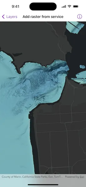
Create a raster layer from a raster image service.
Use case
Accessing a raster image from an online service can be useful for analysing the most up-to-date data available for an area. For example, retrieving recent results of bathymetry surveys within a shipping channel monitored for its sediment build-up would allow planners to assess dredging needs.
How to use the sample
Simply launch the sample to see a raster from an image service being used on a map.
How it works
- Create an
ImageServiceRasterusing the service’s URL. - Create a
RasterLayerfrom the image service raster. - Add the raster layer to the map.
Relevant API
- ImageServiceRaster
- RasterLayer
About the data
This sample uses a NOAA raster image service. The service computes a bathymetry image from the depth (in meters) of U.S. coastal waters.
Tags
image service, raster
Sample code
AddRasterFromServiceView.swift
// Copyright 2024 Esri//// Licensed under the Apache License, Version 2.0 (the "License");// you may not use this file except in compliance with the License.// You may obtain a copy of the License at////   https://www.apache.org/licenses/LICENSE-2.0//// Unless required by applicable law or agreed to in writing, software// distributed under the License is distributed on an "AS IS" BASIS,// WITHOUT WARRANTIES OR CONDITIONS OF ANY KIND, either express or implied.// See the License for the specific language governing permissions and// limitations under the License.
import ArcGISimport SwiftUI
struct AddRasterFromServiceView: View {    /// The error shown in the error alert.    @State private var error: (any Error)?
    /// The current draw status of the map.    @State private var currentDrawStatus: DrawStatus = .inProgress
    /// A map with a dark gray basemap and a raster layer.    @State private var map: Map = {        let map = Map(basemapStyle: .arcGISDarkGrayBase)        // Creates an initial viewpoint with a coordinate point centered on        // San Francisco's Golden Gate Bridge.        map.initialViewpoint = Viewpoint(            center: Point(x: -13_637_000, y: 4_550_000, spatialReference: .webMercator),            scale: 100_000        )        // Creates a raster from an image service.        let imageServiceRaster = ImageServiceRaster(url: .imageServiceURL)        // Creates a raster layer from the raster.        let rasterLayer = RasterLayer(raster: imageServiceRaster)        map.addOperationalLayer(rasterLayer)        return map    }()
    /// The raster layer in the map.    private var rasterLayer: RasterLayer {        map.operationalLayers.first as! RasterLayer    }
    var body: some View {        MapView(map: map)            .onDrawStatusChanged { drawStatus in                // Updates the state when the map's draw status changes.                withAnimation {                    currentDrawStatus = drawStatus                }            }            .overlay(alignment: .center) {                if currentDrawStatus == .inProgress {                    ProgressView("Drawing")                        .padding()                        .background(.ultraThinMaterial)                        .clipShape(.rect(cornerRadius: 10))                        .shadow(radius: 50)                }            }            .task {                do {                    // Loads a raster layer from online service.                    try await rasterLayer.load()                } catch {                    // Presents an error message if the raster fails to load.                    self.error = error                }            }            .errorAlert(presentingError: $error)    }}
private extension URL {    static let imageServiceURL = URL(string: "https://gis.ngdc.noaa.gov/arcgis/rest/services/bag_bathymetry/ImageServer")!}
#Preview {    AddRasterFromServiceView()}