Group a collection of layers together and toggle their visibility as a group.
Use case
Group layers communicate to the user that layers are related and can be managed together. In a land development project, you might group layers according to the phase of development.
How to use the sample
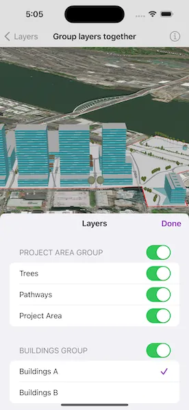
The layers in the map will be displayed in a table of contents. For project area group layers, toggle the switch next to a layer’s name. For the buildings group layers, tap the cell to change its visibility. Turning a group layer’s visibility off will override the visibility of its child layers.
How it works
- Create an empty
GroupLayer. - Add a child layer to the group layer’s layers collection.
- Set the group layer’s
visibilityModeto change its behavior:
independentallows each sublayer to change its visibility independently.exclusiveallows only one sublayer to be visible at a time.inheritedtreats the group layer as if it is one merged layer.
- To toggle the visibility of the group, simply change the group layer’s
isVisibleproperty.
Relevant API
- GroupLayer
- GroupLayer.VisibilityMode
- LayerContent
Additional information
The full extent of a group layer may change when child layers are added/removed. Group layers do not have a spatial reference, but the full extent will have the spatial reference of the first child layer.
Group layers can be saved to web scenes. In web maps, group layers will be ignored.
Tags
3D, group layer, layers
Sample code
// Copyright 2023 Esri//// Licensed under the Apache License, Version 2.0 (the "License");// you may not use this file except in compliance with the License.// You may obtain a copy of the License at////   https://www.apache.org/licenses/LICENSE-2.0//// Unless required by applicable law or agreed to in writing, software// distributed under the License is distributed on an "AS IS" BASIS,// WITHOUT WARRANTIES OR CONDITIONS OF ANY KIND, either express or implied.// See the License for the specific language governing permissions and// limitations under the License.
import ArcGISimport SwiftUI
struct GroupLayersTogetherView: View {    /// A scene with an imagery basemap and a world elevations source.    @State private var scene: ArcGIS.Scene = {        let scene = Scene(basemapStyle: .arcGISImagery)
        // Add base surface to the scene for elevation data.        let elevationSource = ArcGISTiledElevationSource(url: .worldElevationService)        let surface = Surface()        surface.addElevationSource(elevationSource)        scene.baseSurface = surface        return scene    }()
    /// The current viewpoint of the scene view.    @State private var viewpoint: Viewpoint?
    /// A Boolean value that indicates whether the layers sheet is showing.    @State private var isShowingLayersSheet = false
    var body: some View {        SceneView(scene: scene, viewpoint: viewpoint)            .onViewpointChanged(kind: .centerAndScale) { viewpoint = $0 }            .task {                // Add group layers to the scene as operational layers.                scene.addOperationalLayers([makeProjectAreaGroupLayer(), makeBuildingsGroupLayer()])
                // Ensure all group layers' child layers are loaded.                for groupLayer in scene.operationalLayers as! [GroupLayer] {                    await groupLayer.layers.load()                }
                // Set the scene's viewpoint with the extent of the project area group layer.                if let extent = scene.operationalLayers.first?.fullExtent {                    let camera = Camera(lookingAt: extent.center, distance: 700, heading: 0, pitch: 60, roll: 0)                    viewpoint = Viewpoint(latitude: .nan, longitude: .nan, scale: .nan, camera: camera)                }            }            .toolbar {                ToolbarItem(placement: .bottomBar) {                    Button("Layers") {                        isShowingLayersSheet = true                    }                    .popover(isPresented: $isShowingLayersSheet) {                        layersList                            .presentationDetents([.fraction(0.5)])                            .frame(idealWidth: 320, idealHeight: 380)                    }                }            }    }
    /// The list of group layers and their child layers that are currently added to the map.    private var layersList: some View {        NavigationStack {            List {                ForEach(scene.operationalLayers as! [GroupLayer], id: \.name) { groupLayer in                    GroupLayerListView(groupLayer: groupLayer)                }            }            .navigationTitle("Layers")            .navigationBarTitleDisplayMode(.inline)            .toolbar {                ToolbarItem(placement: .confirmationAction) {                    Button("Done") {                        isShowingLayersSheet = false                    }                }            }        }    }}
extension GroupLayersTogetherView {    /// Creates the project area group layer from individual child layers.    /// - Returns: A `GroupLayer` object.    private func makeProjectAreaGroupLayer() -> GroupLayer {        // Create a group layer and set its name.        let groupLayer = GroupLayer()        groupLayer.name = "Project area group"
        // Create a scene layer for the trees.        let treesLayer = ArcGISSceneLayer(url: .trees)
        // Create a feature layer for the pathways.        let pathwaysTable = ServiceFeatureTable(url: .pathways)        let pathwaysLayer = FeatureLayer(featureTable: pathwaysTable)        pathwaysLayer.sceneProperties.altitudeOffset = 1        pathwaysLayer.sceneProperties.surfacePlacement = .relative
        // Create a feature layer for the project area.        let projectAreaTable = ServiceFeatureTable(url: .projectArea)        let projectAreaLayer = FeatureLayer(featureTable: projectAreaTable)
        // Add the scene and feature layers as children of the group layer.        groupLayer.addLayers([treesLayer, pathwaysLayer, projectAreaLayer])        return groupLayer    }
    /// Creates the buildings group layer from individual child layers.    /// - Returns: A `GroupLayer` object.    private func makeBuildingsGroupLayer() -> GroupLayer {        // Create a group layer and set its name.        let groupLayer = GroupLayer()        groupLayer.name = "Buildings group"
        // Create layers for the buildings.        let buildingsALayer = ArcGISSceneLayer(url: .buildingsA)        let buildingsBLayer = ArcGISSceneLayer(url: .buildingsB)
        // Add the scene layers as children of the group layer.        groupLayer.addLayers([buildingsALayer, buildingsBLayer])
        // Set the visibility mode to exclusive so only one sublayer can be visible        // at a time.        groupLayer.visibilityMode = .exclusive        return groupLayer    }}
private extension URL {    /// A URL for a world elevation service from Terrain3D ArcGIS REST service.    static var worldElevationService: URL {        URL(string: "https://elevation3d.arcgis.com/arcgis/rest/services/WorldElevation3D/Terrain3D/ImageServer")!    }
    /// A URL for the tress scene service.    static var trees: URL {        URL(string: "https://tiles.arcgis.com/tiles/P3ePLMYs2RVChkJx/arcgis/rest/services/DevA_Trees/SceneServer")!    }
    /// A URL for the pathways feature service.    static var pathways: URL {        URL(string: "https://services.arcgis.com/P3ePLMYs2RVChkJx/arcgis/rest/services/DevA_Pathways/FeatureServer/1")!    }
    /// A URL for the project area feature service.    static var projectArea: URL {        URL(string: "https://services.arcgis.com/P3ePLMYs2RVChkJx/arcgis/rest/services/DevelopmentProjectArea/FeatureServer/0")!    }
    /// A URL for the buildings A scene service.    static var buildingsA: URL {        URL(string: "https://tiles.arcgis.com/tiles/P3ePLMYs2RVChkJx/arcgis/rest/services/DevA_BuildingShells/SceneServer")!    }
    /// A URL for the buildings B scene service.    static var buildingsB: URL {        URL(string: "https://tiles.arcgis.com/tiles/P3ePLMYs2RVChkJx/arcgis/rest/services/DevB_BuildingShells/SceneServer")!    }}
#Preview {    NavigationStack {        GroupLayersTogetherView()    }}
// Copyright 2023 Esri//// Licensed under the Apache License, Version 2.0 (the "License");// you may not use this file except in compliance with the License.// You may obtain a copy of the License at//// https://www.apache.org/licenses/LICENSE-2.0//// Unless required by applicable law or agreed to in writing, software// distributed under the License is distributed on an "AS IS" BASIS,// WITHOUT WARRANTIES OR CONDITIONS OF ANY KIND, either express or implied.// See the License for the specific language governing permissions and// limitations under the License.
import ArcGISimport SwiftUI
extension GroupLayersTogetherView { struct GroupLayerListView: View { /// The group layer to display in the list section. let groupLayer: GroupLayer
/// A Boolean that indicates whether the section body is disabled. @State private var isDisabled = false
/// The name of the current visible child layer of a group layer with an exclusive visibility mode. @State private var exclusiveLayerSelection = ""
var body: some View { Section { Group { // Create a sublayer list based on the group layer's visibility mode. switch groupLayer.visibilityMode { case .independent: // Toggles for sublayers that can change their visibility independently. ForEach(groupLayer.layers, id: \.name) { layer in LayerVisibilityToggle(formatLayerName(of: layer.name), layer: layer) }
case .exclusive: // Picker for when only one sublayer can be visible at a time. Picker("Exclusive Layer", selection: $exclusiveLayerSelection) { ForEach(groupLayer.layers, id: \.name) { layer in Text(formatLayerName(of: layer.name)) .onChange(of: exclusiveLayerSelection) { layer.isVisible = layer.name == exclusiveLayerSelection } } } .pickerStyle(.inline) .labelsHidden()
case .inherited: // Layer names for sublayers that are treated as one merged layer. ForEach(groupLayer.layers, id: \.name) { layer in Text(formatLayerName(of: layer.name)) }
@unknown default: fatalError("Unknown visibility mode: \(groupLayer.visibilityMode) for GroupLayer: \(groupLayer.name)") } } .disabled(isDisabled) } header: { LayerVisibilityToggle(groupLayer.name, layer: groupLayer) } .task { // Listen for changes to is visible to disable the section // body when the group layer is not visible. for await isVisible in groupLayer.$isVisible { isDisabled = !isVisible } } .onAppear { // Set the picker selection to the current visible child on appear. if groupLayer.visibilityMode == .exclusive { exclusiveLayerSelection = groupLayer.layers.first( where: { $0.isVisible == true } )?.name ?? "" } } }
/// Formats a layer's name to be more human readable. /// - Parameter name: The original `String` name of the layer. /// - Returns: A `String` with the modified name or the original if the name is not found. private func formatLayerName(of name: String) -> String { switch name { case "DevA_Trees": return "Trees" case "DevA_Pathways": return "Pathways" case "DevA_BuildingShells": return "Buildings A" case "DevB_BuildingShells": return "Buildings B" case "DevelopmentProjectArea": return "Project Area" default: return name } } }
/// A toggle for changing a given layer's visibility. private struct LayerVisibilityToggle: View { /// The title of the toggle. private let title: String
/// The layer with the visibility to change. private let layer: Layer
/// A Boolean value indicating whether the layer's content is visible. @State private var isVisible: Bool
/// Creates the toggle for changing a given layer's visibility. /// - Parameters: /// - title: A string for the title of the toggle. /// - layer: The layer with the visibility to change. init(_ title: String, layer: Layer) { self.title = title self.layer = layer self.isVisible = layer.isVisible }
var body: some View { Toggle(title, isOn: $isVisible) .onChange(of: isVisible) { layer.isVisible = isVisible } } }}