An OrbitGeoElementCameraController follows a graphic while the graphic’s position and rotation are animated.
Use case
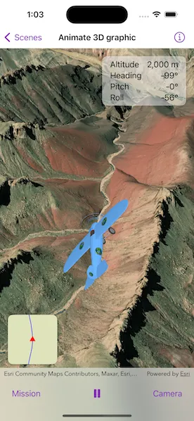
Visualize movement through a 3D landscape.
How to use the sample
Tap the buttons on the bottom toolbar to adjust the settings for the animation:
- Mission: change the flight path, speed, and view progress
- Play/Pause: toggle the animation
- Camera: change the camera distance, heading, pitch, and other camera properties.
How it works
- Create a
GraphicsOverlayand add it to theSceneView. - Create a
ModelSceneSymbolobject. - Create a
Graphicobject with the model scene symbol. - Add heading, pitch, and roll attributes to the graphic.
- Create a
SimpleRendererobject and set its expression properties. - Add the graphic and the renderer to the graphics overlay.
- Create a
OrbitGeoElementCameraControllerwhich is set to target the graphic. - Assign the camera controller to the
SceneView. - Update the graphic’s location, heading, pitch, and roll.
Relevant API
- Camera
- GlobeCameraController
- Graphic
- GraphicsOverlay
- LayerSceneProperties
- ModelSceneSymbol
- OrbitGeoElementCameraController
- Renderer
- RendererSceneProperties
- Scene
- SceneView
- SurfacePlacement
Offline data
This sample uses the following data which are all included and downloaded on-demand:
- Model Marker Symbol Data
- GrandCanyon.csv mission data
- Hawaii.csv mission data
- Pyrenees.csv mission data
- Snowdon.csv mission data
Tags
animation, camera, heading, pitch, roll, rotation, visualize
Sample code
// Copyright 2023 Esri//// Licensed under the Apache License, Version 2.0 (the "License");// you may not use this file except in compliance with the License.// You may obtain a copy of the License at////   https://www.apache.org/licenses/LICENSE-2.0//// Unless required by applicable law or agreed to in writing, software// distributed under the License is distributed on an "AS IS" BASIS,// WITHOUT WARRANTIES OR CONDITIONS OF ANY KIND, either express or implied.// See the License for the specific language governing permissions and// limitations under the License.
import ArcGISimport SwiftUI
struct Animate3DGraphicView: View {    /// The view model for the sample.    @StateObject private var model = Model()
    /// A Boolean value that indicates whether the full map view is showing.    @State private var isShowingFullMap = false
    var body: some View {        ZStack {            /// The scene view with the plane model graphic.            SceneView(                scene: model.scene,                cameraController: model.cameraController,                graphicsOverlays: [model.sceneGraphicsOverlay]            )
            /// The stats of the current position of the plane.            VStack {                HStack {                    Spacer()                    VStack(spacing: 3) {                        LabeledContent("Altitude", value: model.animation.currentFrame.altitude, format: .length)                        LabeledContent("Heading", value: model.animation.currentFrame.heading, format: .angle)                        LabeledContent("Pitch", value: model.animation.currentFrame.pitch, format: .angle)                        LabeledContent("Roll", value: model.animation.currentFrame.roll, format: .angle)                    }                    .frame(width: 170, height: 100)                    .padding([.leading, .trailing])                    .background(.ultraThinMaterial)                    .clipShape(.rect(cornerRadius: 10))                    .shadow(radius: 3)                }                .padding()                Spacer()            }
            /// The map view that tracks the plane on a 2D map.            VStack {                Spacer()                HStack {                    MapView(map: model.map, viewpoint: model.viewpoint, graphicsOverlays: [model.mapGraphicsOverlay])                        .interactionModes([])                        .attributionBarHidden(true)                        .onSingleTapGesture { _, _ in                            // Show/hide full map on tap.                            withAnimation(.default.speed(2)) {                                isShowingFullMap.toggle()                            }                        }                        .frame(width: isShowingFullMap ? nil : 100, height: isShowingFullMap ? nil : 100)                        .clipShape(.rect(cornerRadius: 10))                        .shadow(radius: 3)                    Spacer()                }                .padding()                .padding(.bottom)            }        }        .toolbar {            ToolbarItemGroup(placement: .bottomBar) {                SettingsView(label: "Mission") {                    missionSettings                }                Spacer()
                /// The play/pause button for the animation.                Button {                    model.animation.isPlaying.toggle()                } label: {                    Image(systemName: model.animation.isPlaying ? "pause.fill" : "play.fill")                }                .onDisappear {                    model.animation.displayLink?.invalidate()                }
                Spacer()
                SettingsView(label: "Camera") {                    cameraSettings                }            }        }        .task {            await model.monitorCameraController()        }    }
    /// The list containing the mission settings.    private var missionSettings: some View {        List {            Section("Mission") {                VStack {                    LabeledContent("Progress", value: model.animation.progress, format: .rounded)                    ProgressView(value: model.animation.progress)                }                .padding(.vertical)
                Picker("Mission Selection", selection: $model.currentMission) {                    ForEach(Mission.allCases, id: \.self) { mission in                        Text(mission.label)                    }                }                .pickerStyle(.inline)                .labelsHidden()            }
            Section("Speed") {                Picker("Animation Speed", selection: $model.animation.speed) {                    ForEach(AnimationSpeed.allCases, id: \.self) { speed in                        Text(String(describing: speed).capitalized)                    }                }                .pickerStyle(.inline)                .labelsHidden()            }        }    }
    /// The list containing the camera controller settings.    private var cameraSettings: some View {        List {            Section {                ForEach(CameraProperty.allCases, id: \.self) { property in                    VStack {                        LabeledContent(property.label, value: model.cameraPropertyTexts[property] ?? "")                        Slider(value: cameraPropertyBinding(for: property), in: property.range, step: 1)                            .padding(.horizontal)                    }                }            }
            Section {                Toggle("Auto-Heading", isOn: $model.cameraController.autoHeadingIsEnabled)                Toggle("Auto-Pitch", isOn: $model.cameraController.autoPitchIsEnabled)                Toggle("Auto-Roll", isOn: $model.cameraController.autoRollIsEnabled)            }        }    }}
private extension Animate3DGraphicView {    /// Creates a binding to a camera controller property based on a given property.    /// - Parameter property: The property associated with a corresponding camera controller property.    /// - Returns: A binding to a camera controller property on the model.    func cameraPropertyBinding(for property: CameraProperty) -> Binding<Double> {        switch property {        case .distance: return $model.cameraController.cameraDistance        case .heading: return $model.cameraController.cameraHeadingOffset        case .pitch: return $model.cameraController.cameraPitchOffset        }    }}
private extension FormatStyle where Self == Measurement<UnitLength>.FormatStyle {    /// The format style for length measurements.    static var length: Self {        .measurement(width: .abbreviated, usage: .asProvided, numberFormatStyle: .number.precision(.fractionLength(0)))    }}
private extension FormatStyle where Self == Measurement<UnitAngle>.FormatStyle {    /// The format style for angle measurements.    static var angle: Self {        .measurement(width: .narrow, usage: .asProvided, numberFormatStyle: .number.precision(.fractionLength(0)))    }}
private extension FormatStyle where Self == FloatingPointFormatStyle<Double>.Percent {    /// The format style for rounding percents.    static var rounded: Self {        .percent.rounded(rule: .up, increment: 0.1)    }}
// Copyright 2023 Esri//// Licensed under the Apache License, Version 2.0 (the "License");// you may not use this file except in compliance with the License.// You may obtain a copy of the License at//// https://www.apache.org/licenses/LICENSE-2.0//// Unless required by applicable law or agreed to in writing, software// distributed under the License is distributed on an "AS IS" BASIS,// WITHOUT WARRANTIES OR CONDITIONS OF ANY KIND, either express or implied.// See the License for the specific language governing permissions and// limitations under the License.
import ArcGISimport Combineimport QuartzCore
extension Animate3DGraphicView { /// The view model for the sample. @MainActor class Model: ObservableObject { // MARK: Scene
/// A scene with an imagery basemap and a world elevation source. let scene: ArcGIS.Scene = { let scene = Scene(basemapStyle: .arcGISImagery)
// Set the scene's base surface with an elevation source. let surface = Surface() let elevationSource = ArcGISTiledElevationSource(url: .worldElevationService) surface.addElevationSource(elevationSource) scene.baseSurface = surface
return scene }()
/// The camera controller set to follow the plane model graphic. lazy var cameraController: OrbitGeoElementCameraController = { // Create a camera controller with the plane graphic and the default distance to keep from it. let cameraController = OrbitGeoElementCameraController(target: planeGraphic, distance: 1000)
// Set camera to align its heading with the model graphic by default. cameraController.autoHeadingIsEnabled = true
// Keep the camera still while the model graphic pitches or rolls by default. cameraController.autoPitchIsEnabled = false cameraController.autoRollIsEnabled = false
// Set the min and max distance values between the model graphic and the camera. cameraController.minCameraDistance = CameraProperty.distance.range.lowerBound cameraController.maxCameraDistance = CameraProperty.distance.range.upperBound
return cameraController }()
/// The scene view graphics overlay containing the plane model graphic. private(set) lazy var sceneGraphicsOverlay: GraphicsOverlay = { // Create a graphics overlay and add the plane graphic. let graphicsOverlay = GraphicsOverlay(graphics: [planeGraphic]) graphicsOverlay.sceneProperties.surfacePlacement = .absolute
// Create a renderer and set its expressions. let renderer = SimpleRenderer() renderer.sceneProperties.headingExpression = "[HEADING]" renderer.sceneProperties.pitchExpression = "[PITCH]" renderer.sceneProperties.rollExpression = "[ROLL]" graphicsOverlay.renderer = renderer
return graphicsOverlay }()
/// The plane model scene symbol graphic for the scene. private let planeGraphic: Graphic = { // Create the model symbol for the plane using a URL. let planeModelSymbol = ModelSceneSymbol(url: .bristol, scale: 20) planeModelSymbol.anchorPosition = .center
// Create graphic of the symbol. return Graphic(symbol: planeModelSymbol) }()
// MARK: Map
/// A map with a streets basemap used to display the location of the plane in 2D. let map = Map(basemapStyle: .arcGISStreets)
/// The map view graphics overlay containing the map graphics. private(set) lazy var mapGraphicsOverlay: GraphicsOverlay = { // Create a graphics overlay with the route and triangle graphics. let graphicsOverlay = GraphicsOverlay(graphics: [routeGraphic, triangleGraphic])
// Create a render and set the rotation expression. let renderer = SimpleRenderer() renderer.rotationExpression = "[ANGLE]" graphicsOverlay.renderer = renderer
return graphicsOverlay }()
/// The route line graphic used to represent the plane's route on the map. private let routeGraphic: Graphic = { let lineSymbol = SimpleLineSymbol(style: .solid, color: .blue, width: 1) return Graphic(symbol: lineSymbol) }()
/// The triangle graphic used to represent the plane on the map. private let triangleGraphic: Graphic = { let triangleSymbol = SimpleMarkerSymbol(style: .triangle, color: .red, size: 10) return Graphic(symbol: triangleSymbol) }()
/// The current viewpoint of the map view used to update it as the plane moves. private(set) var viewpoint: Viewpoint?
/// The animation for the sample. @Published var animation = Animation()
/// The current mission selection. @Published var currentMission: Mission = .grandCanyon { didSet { if oldValue != currentMission { updateMission() } } }
/// The text of the camera controller property values used for the camera settings. @Published private(set) var cameraPropertyTexts: [CameraProperty: String] = [:]
init() { // Set up the mission, graphics, and animation. updateMission()
let displayLink = CADisplayLink(target: self, selector: #selector(updatePositions)) animation.setup(displayLink: displayLink) }
// MARK: Methods
/// Monitors the camera controller's properties to update the associated text when they change. func monitorCameraController() async { // The camera controller properties to monitor. let properties: [CameraProperty: AsyncStream<Double>] = [ .distance: cameraController.$cameraDistance, .heading: cameraController.$cameraHeadingOffset, .pitch: cameraController.$cameraPitchOffset ]
// Create a task for each property. await withTaskGroup(of: Void.self) { group in for (name, property) in properties { group.addTask { for await newValue in property { await self.updateCameraPropertyText(for: name, using: newValue) } } } } }
/// Updates the text associated with a given camera controller property. /// - Parameters: /// - property: The camera controller property associated with the text to update. /// - value: The property value used to create the text. private func updateCameraPropertyText(for property: CameraProperty, using value: Double) { let postfix = property == .distance ? " m" : "°" cameraPropertyTexts[property] = "\(value.formatted(.rounded))\(postfix)" }
/// Switches to a new mission by updating the animation and graphics. private func updateMission() { // Reset the animation to the beginning. animation.reset()
// Load the frames of the new mission. animation.loadFrames(for: currentMission.label.replacingOccurrences(of: " ", with: ""))
// Create a polyline for the route using the position of each frame. let points = animation.frames.map(\.position) routeGraphic.geometry = Polyline(points: points)
// Set positions to the starting frame of the mission. updatePositions() }
/// Updates the positions of the graphics and the viewpoint using the current frame. @objc private func updatePositions() { // Get the current frame of the animation. let frame = animation.currentFrame
// Update the position and attributes of the plane model graphic. planeGraphic.geometry = frame.position planeGraphic.setAttributeValue(frame.heading.value, forKey: "HEADING") planeGraphic.setAttributeValue(frame.pitch.value, forKey: "PITCH") planeGraphic.setAttributeValue(frame.roll.value, forKey: "ROLL")
// Update the viewpoint of the map view and the position of the triangle graphic. triangleGraphic.geometry = frame.position viewpoint = Viewpoint(center: frame.position, scale: 100_000, rotation: 360 + frame.heading.value)
// Move to the next frame in the animation. if animation.isPlaying { animation.nextFrame() } } }
/// A struct containing data for an animation. struct Animation { /// The timer used to loop through the animation frames. private(set) var displayLink: CADisplayLink?
/// The speed of the animation. var speed = AnimationSpeed.medium
/// A Boolean value indicating whether the animation is currently playing. var isPlaying = false { didSet { displayLink?.isPaused = !isPlaying } }
/// The current frame of the animation. var currentFrame: Frame { frames[currentFrameIndex] }
/// The current progress of the mission. var progress: Double { Double(currentFrameIndex) / Double(framesCount) }
/// All the frames of the animation. private(set) var frames: [Frame] = [] { didSet { framesCount = frames.count } }
/// The count of the frames. private var framesCount = 0
/// The index of the current frame in the frames list. private var currentFrameIndex = 0
/// Sets up the animation using a given display link. /// - Parameter displayLink: The display link used to run the animation. mutating func setup(displayLink: CADisplayLink) { // Add the display link to main thread common mode run loop, // so it is not effected by UI events. displayLink.add(to: .main, forMode: .common) displayLink.preferredFramesPerSecond = 60 self.displayLink = displayLink }
/// Resets the animation to the beginning. mutating func reset() { isPlaying = false currentFrameIndex = 0 }
/// Increments the animation to the next frame based on the speed. mutating func nextFrame() { // Increment the frame index using the current speed. let nextFrameIndex = currentFrameIndex + speed.rawValue if frames.indices.contains(nextFrameIndex) { currentFrameIndex = nextFrameIndex } else { // Reset the animation when it has reached the end. reset() } }
/// Loads the frames of a mission from a CSV file. /// - Parameter filename: The name of the file containing the CSV data. mutating func loadFrames(for filename: String) { // Get the content of the file from the bundle using the filename name. guard let url = Bundle.main.url(forResource: filename, withExtension: "csv"), let content = try? String(contentsOf: url, encoding: .utf8) else { return }
// Split the content by line into an array. let lines = content.split(whereSeparator: \.isNewline)
// Create a frame for each line. frames = lines.map { line in // Spilt the line data into an array. let details = line.components(separatedBy: ",") let position = Point( x: Double(details[0])!, y: Double(details[1])!, z: Double(details[2])!, spatialReference: .wgs84 ) return Frame( position: position, heading: Measurement(value: Double(details[3])!, unit: .degrees), pitch: Measurement(value: Double(details[4])!, unit: .degrees), roll: Measurement(value: Double(details[5])!, unit: .degrees) ) } } }
/// A struct containing the location data for a single frame in a 3D animation. struct Frame { let position: Point let heading: Measurement<UnitAngle> let pitch: Measurement<UnitAngle> let roll: Measurement<UnitAngle>
var altitude: Measurement<UnitLength> { Measurement(value: position.z ?? 0, unit: .meters) } }
/// An enumeration of the different mission selections available in this sample. enum Mission: CaseIterable { case grandCanyon, hawaii, pyrenees, snowdon
/// A human-readable label of the mission name. var label: String { switch self { case .grandCanyon: "Grand Canyon" case .hawaii: "Hawaii" case .pyrenees: "Pyrenees" case .snowdon: "Snowdon" } } }
/// An enumeration representing the different async properties of the camera controller. enum CameraProperty: CaseIterable { case distance, heading, pitch
/// A human-readable label of the property. var label: String { switch self { case .distance: return "Camera Distance" case .heading: return "Heading Offset" case .pitch: return "Pitch Offset" } }
/// The range of values associated with the property. var range: ClosedRange<Double> { switch self { case .distance: return 500...8000 case .heading: return -180...180 case .pitch: return 0...180 } } }
/// An enumeration representing the speed of the animation. enum AnimationSpeed: Int, CaseIterable { case slow = 1 case medium = 2 case fast = 4 }}
private extension FormatStyle where Self == FloatingPointFormatStyle<Double> { /// The format style for rounding up decimals. static var rounded: Self { .number.rounded(rule: .up, increment: 1) }}
private extension URL { /// A URL to world elevation service from Terrain3D ArcGIS REST service. static var worldElevationService: Self { .init(string: "https://elevation3d.arcgis.com/arcgis/rest/services/WorldElevation3D/Terrain3D/ImageServer")! }
/// A URL to the local Bristol 3D model files. static var bristol: Self { Bundle.main.url(forResource: "Bristol", withExtension: "dae", subdirectory: "Bristol")! }}// Copyright 2023 Esri//// Licensed under the Apache License, Version 2.0 (the "License");// you may not use this file except in compliance with the License.// You may obtain a copy of the License at//// https://www.apache.org/licenses/LICENSE-2.0//// Unless required by applicable law or agreed to in writing, software// distributed under the License is distributed on an "AS IS" BASIS,// WITHOUT WARRANTIES OR CONDITIONS OF ANY KIND, either express or implied.// See the License for the specific language governing permissions and// limitations under the License.
import SwiftUI
extension Animate3DGraphicView { /// A view consisting of a sheet of settings controlled by a button. struct SettingsView<Content: View>: View { /// The name of the settings for the button and sheet title. let label: String
/// The settings content to show in the sheet. @ViewBuilder let content: Content
/// A Boolean value that indicates whether the sheet is currently showing. @State private var isPresented = false
var body: some View { Button(label) { isPresented = true } .popover(isPresented: $isPresented) { settingsContent .presentationDetents([.fraction(0.5)]) .frame(idealWidth: 320, idealHeight: 380) } }
/// The view content of the settings sheet. private var settingsContent: some View { NavigationStack { content .navigationTitle("\(label) Settings") .navigationBarTitleDisplayMode(.inline) .toolbar { ToolbarItem(placement: .confirmationAction) { Button("Done") { isPresented = false } } } } } }}