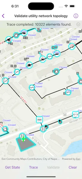
Demonstrates the workflow of getting the network state and validating the topology of a utility network.
Use case
Dirty areas are generated where edits to utility network features have not been evaluated against the network rules. Tracing across this area could result in an error or return inaccurate results. Validating the utility network updates the network topology with the edited feature data, maintaining consistency between the features and topology. Querying the network state allows you to determine if there are dirty areas or errors in a utility network, and if it supports network topology.
How to use the sample
Select a feature to make edits and then tap “Apply” to send edits to the server.
- Tap “Get state” to check if validate is required or if tracing is available.
- Tap “Validate” to validate network topology and clear dirty areas.
- Tap “Trace” to run a trace.
How it works
- Create and load a
Mapwith a web map item URL. - Load the
UtilityNetworkfrom the web map and switch itsServiceGeodatabaseto a new branch version. - Add
LabelDefinitions for the fields that will be updated on a feature edit. - Add the
UtilityNetwork.dirtyAreaTableto the map to visualize dirty areas or errors. - Set a default starting location and trace parameters to stop traversability on an open device.
- Get the
UtilityNetworkCapabilitiesfrom theUtilityNetworkDefinitionand use these values to enable or disable the ‘Get State’, ‘Validate’, and ‘Trace’ buttons. - When an
ArcGISFeatureis selected for editing, populate the choice list for the field value using the field’sCodedValueDomain.codedValues. - When “Apply” is tapped, update the value of the selected feature’s attribute value with the selected
CodedValue.codeand callServiceGeodatabase.applyEdits(). - When “Get State” is tapped, call
UtilityNetwork.stateand print the results. - When “Validate” is tapped, get the current map extent and call
UtilityNetwork.validateNetworkTopology(forExtent:executionType:). - When “Trace” is tapped, call
UtilityNetwork.trace(using:)with the predefined parameters and select all features returned. - When “Clear” or “Cancel” are tapped, clear all selected features on each layer in the map and close the attribute picker.
Relevant API
- UtilityElement
- UtilityElementTraceResult
- UtilityNetwork
- UtilityNetworkCapabilities
- UtilityNetworkState
- UtilityNetworkValidationJob
- UtilityTraceConfiguration
- UtilityTraceParameters
- UtilityTraceResult
About the data
The Naperville electric feature service contains a utility network that can be used to query the network state and validate network topology before tracing. The Naperville electric webmap uses the same feature service endpoint and is shown in this sample. Authentication is required and handled within the sample code.
Additional information
Starting from 200.4, an Advanced Editing extension is required for editing a utility network in the following cases:
- Stand-alone mobile geodatabase that is exported from ArcGIS Pro 2.7 or higher
- Sync-enabled mobile geodatabase that is generated from an ArcGIS Enterprise Feature Service 11.2 or higher
- Web map or service geodatabase that points to an ArcGIS Enterprise Feature Service 11.2 or higher
Please refer to the “Advanced Editing” section in the extension license table in License and deployment for details.
Tags
dirty areas, edit, network topology, online, state, trace, utility network, validate
Sample code
// Copyright 2024 Esri//// Licensed under the Apache License, Version 2.0 (the "License");// you may not use this file except in compliance with the License.// You may obtain a copy of the License at////   https://www.apache.org/licenses/LICENSE-2.0//// Unless required by applicable law or agreed to in writing, software// distributed under the License is distributed on an "AS IS" BASIS,// WITHOUT WARRANTIES OR CONDITIONS OF ANY KIND, either express or implied.// See the License for the specific language governing permissions and// limitations under the License.
import ArcGISimport SwiftUI
struct ValidateUtilityNetworkTopologyView: View {    /// The view model for the sample.    @StateObject private var model = Model()
    /// The visible area on the map.    @State private var visibleArea: ArcGIS.Polygon?
    /// The operation on the model currently being executed.    @State private var selectedOperation: ModelOperation = .setup
    /// A Boolean value indicating whether a model operation is in progress.    @State private var operationIsRunning = false
    /// A Boolean value indicating whether the edit feature sheet is presented.    @State private var editSheetIsPresented = false
    /// The error shown in the error alert.    @State private var error: (any Error)?
    var body: some View {        MapViewReader { mapViewProxy in            MapView(map: model.map, graphicsOverlays: [model.graphicsOverlay])                .onVisibleAreaChanged { visibleArea = $0 }                .onSingleTapGesture { screenPoint, _ in                    selectedOperation = .selectFeature(screenPoint: screenPoint)                }                .contentInsets(.init(top: 0, leading: 0, bottom: 350, trailing: 0))                .task(id: selectedOperation) {                    operationIsRunning = true                    defer { operationIsRunning = false }
                    do {                        switch selectedOperation {                        case .setup:                            try await model.setup()
                        case .getState:                            try await model.getState()
                        case .trace:                            try await model.trace()
                        case .validateNetworkTopology:                            guard let extent = visibleArea?.extent else { return }                            try await model.validate(forExtent: extent)
                        case .selectFeature(let screenPoint):                            // Identify the tapped layers using the map view proxy.                            let identifyResults = try await mapViewProxy.identifyLayers(                                screenPoint: screenPoint!,                                tolerance: 5                            )                            model.selectFeature(from: identifyResults)
                            // Present the sheet to edit the feature if one was selected.                            if let feature = model.feature {                                editSheetIsPresented = true
                                guard let featureCenter = feature.geometry?.extent.center else { return }                                await mapViewProxy.setViewpointCenter(featureCenter)                            } else {                                model.statusMessage = "No feature identified. Tap on a feature."                            }
                        case .applyEdits:                            try await model.applyEdits()
                        case .clearSelection:                            model.clearSelection()                            model.statusMessage = "Selection cleared."                        }                    } catch {                        model.statusMessage = selectedOperation.errorMessage                        self.error = error                    }                }        }        .overlay(alignment: .top) {            CollapsibleText(text: $model.statusMessage)                .frame(maxWidth: .infinity, alignment: .center)                .padding(8)                .background(.ultraThinMaterial, ignoresSafeAreaEdges: .horizontal)        }        .overlay(alignment: .center) {            if operationIsRunning {                ProgressView()                    .padding()                    .background(.ultraThickMaterial)                    .clipShape(.rect(cornerRadius: 10))                    .shadow(radius: 50)            }        }        .toolbar {            ToolbarItemGroup(placement: .bottomBar) {                Button("Get State") { selectedOperation = .getState }                    .disabled(!model.canGetState)                Spacer()                Button("Trace") { selectedOperation = .trace }                    .disabled(!model.canTrace)                Spacer()                Button("Validate") { selectedOperation = .validateNetworkTopology }                    .disabled(!model.canValidateNetworkTopology)                Spacer()                Button("Clear") { selectedOperation = .clearSelection }                    .disabled(!model.canClearSelection)                    .popover(isPresented: $editSheetIsPresented) {                        EditFeatureView(model: model, operationSelection: $selectedOperation)                            .onDisappear {                                if selectedOperation != .applyEdits {                                    // Clear the selection if the sheet was dismissed without applying.                                    selectedOperation = .clearSelection                                }                            }                            .presentationDetents([.fraction(0.5)])                            .frame(idealWidth: 320, idealHeight: 240)                    }            }        }        .errorAlert(presentingError: $error)        .onTeardown {            model.tearDown()        }    }}
extension ValidateUtilityNetworkTopologyView {    /// An enumeration representing an operation run on the view model.    enum ModelOperation: Equatable {        /// Setup the model.        case setup        /// Get the state of the utility network.        case getState        /// Run a utility network trace.        case trace        /// Validate the utility network topology.        case validateNetworkTopology        /// Select a feature on the map at a given screen point.        case selectFeature(screenPoint: CGPoint? = nil)        /// Apply the edits to the feature to the service.        case applyEdits        /// Clear the selected feature(s).        case clearSelection
        /// The message to display if the operations fails.        var errorMessage: String {            switch self {            case .setup:                "Initialization failed."            case .getState:                "Get state failed."            case .trace:                "Trace failed. \nTap 'Get State' to check the updated network state."            case .selectFeature:                "Select feature failed."            case .validateNetworkTopology:                "Validate network topology failed."            case .applyEdits:                "Apply edits failed."            case .clearSelection:                ""            }        }    }}
#Preview {    NavigationStack {        ValidateUtilityNetworkTopologyView()    }}
// Copyright 2024 Esri//// Licensed under the Apache License, Version 2.0 (the "License");// you may not use this file except in compliance with the License.// You may obtain a copy of the License at//// https://www.apache.org/licenses/LICENSE-2.0//// Unless required by applicable law or agreed to in writing, software// distributed under the License is distributed on an "AS IS" BASIS,// WITHOUT WARRANTIES OR CONDITIONS OF ANY KIND, either express or implied.// See the License for the specific language governing permissions and// limitations under the License.
import ArcGISimport Combineimport UIKit
extension ValidateUtilityNetworkTopologyView { /// The view model for the sample. @MainActor class Model: ObservableObject { // MARK: Properties
/// A map with no specified style. private(set) var map = Map()
/// The graphics overlay for the starting location graphic. let graphicsOverlay: GraphicsOverlay = { let greenCrossSymbol = SimpleMarkerSymbol(style: .cross, color: .green, size: 25) let graphic = Graphic(symbol: greenCrossSymbol) return GraphicsOverlay(graphics: [graphic]) }()
/// The utility network for the sample. private var utilityNetwork: UtilityNetwork!
/// The trace parameters for tracing with the utility network. private var traceParameters: UtilityTraceParameters!
/// The feature currently being edited. private(set) var feature: ArcGISFeature?
/// The feature's field currently being edited. private(set) var field: Field?
/// The coded values from the field's domain. private(set) var fieldValueOptions: [CodedValue] = []
/// The selected field coded value. @Published var selectedFieldValue: CodedValue?
/// The text representing the current status. @Published var statusMessage = ""
/// A Boolean value indicating whether the current state of the utility network can be obtained. @Published private(set) var canGetState = false
/// A Boolean value indicating whether a trace can be run. @Published private(set) var canTrace = false
/// A Boolean value indicating whether the utility network topology can be validated. @Published private(set) var canValidateNetworkTopology = false
/// A Boolean value indicating whether there is a selection that can be cleared. @Published private(set) var canClearSelection = false
// MARK: Methods
/// Gets the current state of the utility network and updates the status with the results. func getState() async throws { statusMessage = "Getting utility network state…"
// Get the current state of the utility network. let state = try await utilityNetwork.state
// Allow validating if the network contains any dirty areas or errors. canValidateNetworkTopology = state.hasDirtyAreas || state.hasErrors
// Allow tracing if the network has topology is enabled. canTrace = state.networkTopologyIsEnabled
// Update the status with the state. let instructionMessage = canValidateNetworkTopology ? "Tap 'Validate' before trace or expect a trace error." : "Tap on a feature to edit or tap 'Trace' to run a trace."
statusMessage = """ Utility Network State: Has dirty areas: \(state.hasDirtyAreas) Has errors: \(state.hasErrors) Network topology is enabled: \(state.networkTopologyIsEnabled) \(instructionMessage) """ }
/// Runs a trace and selects features in the map that correspond to the resulting elements. func trace() async throws { statusMessage = "Running a downstream trace…" clearLayerSelections()
// Get the element trace result from the utility network using the trace parameters. let traceResults = try await utilityNetwork.trace(using: traceParameters) guard let elementTraceResult = traceResults.first(where: { $0 is UtilityElementTraceResult }) as? UtilityElementTraceResult else { return }
// Select all of elements found. statusMessage = "Selecting found elements…"
for layer in map.operationalLayers.compactMap({ $0 as? FeatureLayer }) { let layerElements = elementTraceResult.elements.filter { element in element.networkSource.featureTable.tableName == layer.featureTable?.tableName }
if !layerElements.isEmpty { let features = try await utilityNetwork.features(for: layerElements) layer.selectFeatures(features) } } canClearSelection = true
statusMessage = "Trace completed: \(elementTraceResult.elements.count) elements found." }
/// Validates the utility network topology within a given extent and updates the status with the results. func validate(forExtent extent: Envelope) async throws { statusMessage = "Validating utility network topology…"
// Validate the utility network topology with the extent. let job = utilityNetwork.validateNetworkTopology(forExtent: extent) job.start() let result = try await job.result.get()
// Update the status with the result. canValidateNetworkTopology = result.hasDirtyAreas statusMessage = """ Network Validation Result Has dirty areas: \(result.hasDirtyAreas) Has errors: \(result.hasErrors) Tap 'Get State' to check the updated network state. """ }
/// Selects a feature from a given list of identify layer results. /// - Parameter identifyResults: The identify layer results. func selectFeature(from identifyResults: [IdentifyLayerResult]) { clearSelection()
// Get the first feature from the results. let layerResult = identifyResults.first { let layerName = $0.layerContent.name return layerName == .deviceTableName || layerName == .lineTableName } guard let feature = layerResult?.geoElements.first as? ArcGISFeature else { return }
// Get the coded values from the feature's field. let fieldName: String = feature.table?.tableName == .deviceTableName ? .deviceStatusField : .nominalVoltageField
guard let field = feature.table?.field(named: fieldName), let codedValues = (field.domain as? CodedValueDomain)?.codedValues else { return } self.field = field fieldValueOptions = codedValues
// Get the current attribute value from the feature. let fieldValue = feature.attributes[field.name] selectedFieldValue = codedValues.first { valuesAreEqual($0.code, fieldValue) }
// Select the identified feature. let featureLayer = feature.table?.layer as? FeatureLayer featureLayer?.selectFeature(feature) canClearSelection = true self.feature = feature
statusMessage = "Select a new '\(field.alias)'." }
/// Applies the edits to the feature to the service. func applyEdits() async throws { guard let feature, let serviceFeatureTable = feature.table as? ServiceFeatureTable, let serviceGeodatabase = serviceFeatureTable.serviceGeodatabase, let fieldName = field?.name else { return }
// Update the feature with the new value in the it's feature table. statusMessage = "Updating feature…" feature.setAttributeValue(selectedFieldValue?.code, forKey: fieldName) try await serviceFeatureTable.update(feature)
// Apply the edits in the feature table to the service. statusMessage = "Applying edits…" let featureTableEditResults = try await serviceGeodatabase.applyEdits()
// Determine if the attempt to edit resulted in any errors. let didCompleteSuccessfully = featureTableEditResults.allSatisfy { tableEditResult in tableEditResult.editResults.allSatisfy { featureEditResult in !featureEditResult.didCompleteWithErrors } }
// Update the status with the results. canValidateNetworkTopology = true statusMessage = didCompleteSuccessfully ? """ Edits applied successfully. Tap 'Get State' to check the updated network state. """ : "Apply edits completed with error." }
/// Clears the selected feature(s). func clearSelection() { clearLayerSelections() feature = nil canClearSelection = false }
// MARK: Setup
/// Performs setup tasks such as adding credentials, loading the utility network, and setting up the trace parameters. func setup() async throws { // Add the credential to access the web map. try await ArcGISEnvironment.authenticationManager.arcGISCredentialStore.add(.publicSample)
try await setupMap() try await setupUtilityNetwork() try await setupTraceParameters()
// Set the initial states using utility network's capabilities. guard let utilityNetworkCapabilities = utilityNetwork.definition?.capabilities else { return } canGetState = utilityNetworkCapabilities.supportsNetworkState canTrace = utilityNetworkCapabilities.supportsTrace canValidateNetworkTopology = utilityNetworkCapabilities.supportsValidateNetworkTopology canClearSelection = false
statusMessage = """ Utility Network Loaded Tap on a feature to edit. Tap 'Get State' to check if validating is necessary or if tracing is available. Tap 'Trace' to run a trace. """ }
/// Cleans up the model's setup. func tearDown() { ArcGISEnvironment.authenticationManager.arcGISCredentialStore.removeAll() }
/// Sets up and loads the web map. private func setupMap() async throws { statusMessage = "Loading web map…"
// Create a portal item using the portal and id for the Naperville Electric web map. let portal = Portal(url: .sampleServerPortal, connection: .authenticated) let portalItem = PortalItem(portal: portal, id: .napervilleElectric)
// Create and load a map using the portal item. map = Map(item: portalItem) map.initialViewpoint = Viewpoint(center: Point(x: -9815160, y: 5128880), scale: 3640) try await map.load()
// Set the map to load in persistent session mode (workaround for server caching issue). // https://support.esri.com/en-us/bug/asynchronous-validate-request-for-utility-network-servi-bug-000160443 map.loadSettings.featureServiceSessionType = .persistent
// Add labels to the map to visualize attribute editing. addLabels(to: .deviceTableName, for: .deviceStatusField, color: .blue) addLabels(to: .lineTableName, for: .nominalVoltageField, color: .red) }
/// Loads the utility network and switches to a new version on the service. private func setupUtilityNetwork() async throws { statusMessage = "Loading utility network…"
// Get the utility network from the map. utilityNetwork = map.utilityNetworks.first try await utilityNetwork.load()
// Create service version parameters to restrict editing and tracing on a random branch. let uniqueString = UUID().uuidString let parameters = ServiceVersionParameters() parameters.name = "ValidateNetworkTopology_\(uniqueString)" parameters.description = "Validate network topology with ArcGIS Maps SDK." parameters.access = .private
// Create and switch to a new version on the service geodatabase using the parameters. let serviceGeodatabase = utilityNetwork.serviceGeodatabase! let serviceVersionInfo = try await serviceGeodatabase.makeVersion(parameters: parameters) try await serviceGeodatabase.switchToVersion(named: serviceVersionInfo.name)
// Add the dirty area table to the map to visualize it. guard let dirtyAreaTable = utilityNetwork.dirtyAreaTable else { return } try await dirtyAreaTable.load() let featureLayer = FeatureLayer(featureTable: dirtyAreaTable) map.addOperationalLayer(featureLayer) }
/// Sets up the starting location and trace parameters for tracing. private func setupTraceParameters() async throws { statusMessage = "Loading starting location…"
// Constants for creating the starting location and trace parameters. let assetGroupName = "Circuit Breaker" let assetTypeName = "Three Phase" let domainNetworkName = "ElectricDistribution" let tierName = "Medium Voltage Radial"
// Create the default starting location using the utility network. guard let networkSource = utilityNetwork.definition?.networkSource(named: .deviceTableName), let assetGroup = networkSource.assetGroup(named: assetGroupName), let assetType = assetGroup.assetType(named: assetTypeName), let startingLocation = utilityNetwork.makeElement( assetType: assetType, globalID: .globalID ) else { return }
// Set the terminal for the location, in our case, the "Load" terminal. let terminal = startingLocation.assetType.terminalConfiguration?.terminals.first { $0.name == "Load" } startingLocation.terminal = terminal
// Add a graphic to indicate the location on the map. let startFeature = try await utilityNetwork.features(for: [startingLocation]).first graphicsOverlay.graphics.first?.geometry = startFeature?.geometry
// Create downstream trace parameters for the location. traceParameters = UtilityTraceParameters( traceType: .downstream, startingLocations: [startingLocation] )
// Set the configuration to stop traversing on an open device. let domainNetwork = utilityNetwork?.definition?.domainNetwork(named: domainNetworkName) let sourceTier = domainNetwork?.tier(named: tierName) traceParameters?.traceConfiguration = sourceTier?.defaultTraceConfiguration }
// MARK: Helpers
/// Clears the selections for all of the map's operational layers.. private func clearLayerSelections() { for layer in map.operationalLayers.compactMap({ $0 as? FeatureLayer }) { layer.clearSelection() } }
/// Adds labels for a given field name to a layer with a given name. /// - Parameters: /// - layerName: The name of the layer on the map to display the labels on. /// - fieldName: The name of the field to display in the labels. /// - color: The color of the label's text. private func addLabels(to layerName: String, for fieldName: String, color: UIColor) { // Create a expression for the label using the given field name. let expression = SimpleLabelExpression(simpleExpression: "[\(fieldName)]")
// Create a symbol for label's text using the given color. let symbol = TextSymbol(color: color, size: 12) symbol.haloColor = .white symbol.haloWidth = 2
// Create the definition from the expression and text symbol let definition = LabelDefinition(labelExpression: expression, textSymbol: symbol)
// Add the definition to the map layer with the given layer name. let layer = self.map.operationalLayers.first { $0.name == layerName } as? FeatureLayer layer?.addLabelDefinition(definition) layer?.labelsAreEnabled = true }
/// Determines whether the values of two `Any` types are equal. /// - Parameters: /// - lhs: The left hand side value. /// - rhs: The right hand side value. /// - Returns: A Boolean value indicating whether the values are equal. private func valuesAreEqual(_ lhs: Any?, _ rhs: Any?) -> Bool { guard let lhs = lhs as? any Equatable, let rhs = rhs as? any Equatable else { return false }
return lhs.isEqual(to: rhs) || rhs.isEqual(to: lhs) } }}
// MARK: Extensions
private extension Equatable { /// Determines whether a given equatable is equal. /// - Parameter other: The value to compare. /// - Returns: A Boolean value indicating whether the value is equal. func isEqual(to other: any Equatable) -> Bool { guard let other = other as? Self else { return false } return self == other }}
private extension String { /// The name of the "Electric Distribution Device" feature table. static let deviceTableName = "Electric Distribution Device"
/// The name of the device status field in the "Electric Distribution Device" feature table. static let deviceStatusField = "devicestatus"
/// The name of the "Electric Distribution Line" feature table. static let lineTableName = "Electric Distribution Line"
/// The name of the nominal voltage field in the "Electric Distribution Line" feature table. static let nominalVoltageField = "nominalvoltage"}
private extension UUID { /// The global ID of the feature from which the starting location is created. static var globalID: UUID { UUID(uuidString: "1CAF7740-0BF4-4113-8DB2-654E18800028")! }}
private extension URL { /// The URL for the sample server 7 portal. static var sampleServerPortal: URL { URL(string: "https://sampleserver7.arcgisonline.com/portal/sharing/rest")! }}
private extension PortalItem.ID { /// The ID for the "Naperville Electric" portal item on sample server 7. static var napervilleElectric: Self { Self("6e3fc6db3d0b4e6589eb4097eb3e5b9b")! }}
private extension ArcGISCredential { /// The public credentials for the data in this sample. /// - Note: Never hardcode login information in a production application. This is done solely for the sake of the sample. static var publicSample: ArcGISCredential { get async throws { try await TokenCredential.credential( for: .sampleServerPortal, username: "editor01", password: "S7#i2LWmYH75" ) } }}// Copyright 2024 Esri//// Licensed under the Apache License, Version 2.0 (the "License");// you may not use this file except in compliance with the License.// You may obtain a copy of the License at//// https://www.apache.org/licenses/LICENSE-2.0//// Unless required by applicable law or agreed to in writing, software// distributed under the License is distributed on an "AS IS" BASIS,// WITHOUT WARRANTIES OR CONDITIONS OF ANY KIND, either express or implied.// See the License for the specific language governing permissions and// limitations under the License.
import ArcGISimport SwiftUI
extension ValidateUtilityNetworkTopologyView { /// A view allowing a user to edit the attribute field value of the feature. struct EditFeatureView: View { /// The view model for the sample. @ObservedObject var model: Model
/// The current view model operation being executed. @Binding var operationSelection: ModelOperation
/// The action to dismiss the view. @Environment(\.dismiss) private var dismiss: DismissAction
var body: some View { NavigationStack { fieldValuePicker .navigationTitle("Edit Feature") .navigationBarTitleDisplayMode(.inline) .toolbar { ToolbarItem(placement: .cancellationAction) { Button("Cancel") { dismiss() } }
ToolbarItem(placement: .confirmationAction) { Button("Apply") { operationSelection = .applyEdits dismiss() } } } } }
/// The picker for the field value options. private var fieldValuePicker: some View { Form { Section(model.field?.alias ?? "Field") { ForEach(model.fieldValueOptions, id: \.name) { option in Button { model.selectedFieldValue = option } label: { HStack { Text(option.name) Spacer() if option.name == model.selectedFieldValue?.name { Image(systemName: "checkmark") .foregroundStyle(Color.accentColor) } } .contentShape(Rectangle()) } .buttonStyle(.plain) } } } } }
/// Text with a button for collapsing multiple lines into a single one. struct CollapsibleText: View { /// The text to show. @Binding var text: String
/// A Boolean value indicating whether the message is presented. @State private var messageIsPresented = false
/// The first line of the text. private var title: String { text.components(separatedBy: .newlines).first ?? text }
/// The text without the title. private var message: String { var lines = text.components(separatedBy: .newlines) lines.removeFirst() return lines.joined(separator: "\n") }
var body: some View { VStack { HStack { Spacer() Text(title) .fontWeight(messageIsPresented ? .bold : .regular) Spacer() Button { withAnimation { messageIsPresented.toggle() } } label: { Image(systemName: messageIsPresented ? "x" : "chevron.down") .symbolVariant(.circle) } .disabled(message.isEmpty) }
if messageIsPresented { Text(message) } } .multilineTextAlignment(.center) .onChange(of: text) { // Start with the full text showing to notify the user of the change. messageIsPresented = !message.isEmpty } } }}