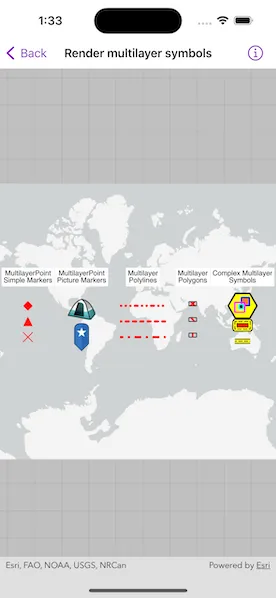
Show different kinds of multilayer symbols on a map similar to some pre-defined 2D simple symbol styles.
Use case
Allows you to customize a graphic with a multilayer symbol. For example, you may want more customizable symbols than the one that is provided with the API to display a unique representation of a landmark.
How to use the sample
The sample loads multilayer symbols for points, polylines, and polygons.
How it works
- Create multilayer symbols for each predefined 2D simple symbol style.
- For multilayer point symbols, use
MultilayerPointSymbol(symbolLayers:referenceProperties:). - For multilayer polyline symbols, use
MultilayerPolylineSymbol(symbolLayers:referenceProperties:). - For multilayer polygon symbols, use
MultiLayerPolygonSymbol(symbolLayers:referenceProperties:).
- For multilayer point symbols, use
- Create graphics by passing in a geometry and the associated symbol.
- Add graphics to the graphics overlay with
graphicsOverlay.addGraphics(_:)
Relevant API
- Graphic
- GraphicsOverlay
- MultiLayerPointSymbol
- MultiLayerPolygonSymbol
- MultiLayerPolylineSymbol
- PictureMarkerSymbolLayer
- SolidFillSymbolLayer
- SolidStrokeSymbolLayer
- VectorMarkerSymbolLayer
About the data
The campsite picture marker symbol is constructed from a URL.
Tags
graphic, marker, multilayer, picture, symbol
Sample code
RenderMultilayerSymbolsView.swift
// Copyright 2023 Esri//// Licensed under the Apache License, Version 2.0 (the "License");// you may not use this file except in compliance with the License.// You may obtain a copy of the License at////   https://www.apache.org/licenses/LICENSE-2.0//// Unless required by applicable law or agreed to in writing, software// distributed under the License is distributed on an "AS IS" BASIS,// WITHOUT WARRANTIES OR CONDITIONS OF ANY KIND, either express or implied.// See the License for the specific language governing permissions and// limitations under the License.
import ArcGISimport SwiftUI
struct RenderMultilayerSymbolsView: View {    /// A map with a light gray basemap.    @State private var map: Map = {        let map = Map(basemapStyle: .arcGISLightGray)        map.initialViewpoint = Viewpoint(boundingGeometry: Point(x: -713_800, y: 0, spatialReference: .webMercator))        return map    }()
    /// The graphics overlay containing the multilayer graphics and associated text graphics.    @State private var graphicsOverlay: GraphicsOverlay = {        let graphicsOverlay = GraphicsOverlay()
        // Create graphics and add them to the graphics overlay.        graphicsOverlay.addGraphics(makeMultilayerPointSimpleMarkerGraphics())        graphicsOverlay.addGraphics(makeMultilayerPointPictureMarkerGraphics())        graphicsOverlay.addGraphics(makeMultilayerPolylineGraphics())        graphicsOverlay.addGraphics(makeMultilayerPolygonGraphics())        graphicsOverlay.addGraphics(makeComplexMultilayerSymbolGraphics())
        return graphicsOverlay    }()
    /// The offset used to keep a consistent distance between symbols in the same column.    private static let offsetBetweenSymbols = 20.0
    var body: some View {        MapView(map: map, graphicsOverlays: [graphicsOverlay])    }}
private extension RenderMultilayerSymbolsView {    // MARK: Methods
    /// Creates a text symbol with the text to be displayed on the map.    /// - Parameter text: The text used to create the text symbol.    /// - Returns: A new `TextSymbol` object.    private static func makeTextSymbol(text: String) -> TextSymbol {        // Create text symbol with a white background.        let textSymbol = TextSymbol(text: text, color: .black, size: 10)        textSymbol.backgroundColor = .white        return textSymbol    }
    // MARK: MultilayerPoint Simple Markers
    /// Creates the multilayer point simple marker graphics.    /// - Returns: The new `Graphic` objects to display on the map.    private static func makeMultilayerPointSimpleMarkerGraphics() -> [Graphic] {        // Create a text graphic.        var graphics = [            Graphic(                geometry: Point(x: -150, y: 50, spatialReference: .wgs84),                symbol: makeTextSymbol(text: "MultilayerPoint\nSimple Markers")            )        ]
        // Create a red diamond graphic from JSON and a multilayer polygon symbol.        let redFillLayer = SolidFillSymbolLayer(color: .red)        let polygonSymbol = MultilayerPolygonSymbol(symbolLayers: [redFillLayer])        if let diamondGeometry = try? Geometry.fromJSON(.diamondGeometryJSON) {            graphics.append(makeGraphicWithVectorMarkerSymbolElement(                symbol: polygonSymbol,                geometry: diamondGeometry,                offset: 0            ))        }
        // Create a triangle graphic from JSON and a multilayer polygon symbol.        if let triangleGeometry = try? Geometry.fromJSON(.triangleGeometryJSON) {            graphics.append(makeGraphicWithVectorMarkerSymbolElement(                symbol: polygonSymbol,                geometry: triangleGeometry,                offset: offsetBetweenSymbols            ))        }
        // Create a cross graphic from JSON and a multilayer polyline symbol.        let redStrokeLayer = SolidStrokeSymbolLayer(width: 1, color: .red)        let polylineSymbol = MultilayerPolylineSymbol(symbolLayers: [redStrokeLayer])        if let crossGeometry = try? Geometry.fromJSON(.crossGeometryJSON) {            graphics.append(makeGraphicWithVectorMarkerSymbolElement(                symbol: polylineSymbol,                geometry: crossGeometry,                offset: offsetBetweenSymbols * 2            ))        }
        return graphics    }
    /// Creates a graphic of multilayer point symbol using a vector marker symbol element.    /// - Parameters:    ///   - symbol: The symbol to create the graphic of.    ///   - geometry: The geometry used to make the vector marker symbol element.    ///   - offset: The offset used to keep a consistent distance between symbols in the same column.    /// - Returns: A new `Graphic` object of the multilayer point symbol.    private static func makeGraphicWithVectorMarkerSymbolElement(        symbol: MultilayerSymbol,        geometry: Geometry,        offset: Double    ) -> Graphic {        // Create a vector element using the passed symbol and geometry.        let vectorElement = VectorMarkerSymbolElement(geometry: geometry, multilayerSymbol: symbol)
        // Create a vector layer using the vector element.        let vectorLayer = VectorMarkerSymbolLayer(vectorMarkerSymbolElements: [vectorElement])
        // Create a point symbol using the vector layer.        let pointSymbol = MultilayerPointSymbol(symbolLayers: [vectorLayer])
        // Create a graphic of the multilayer point symbol.        return Graphic(geometry: Point(x: -150, y: 20 - offset, spatialReference: .wgs84), symbol: pointSymbol)    }
    // MARK: MultilayerPoint Picture Markers
    /// Creates the multilayer point picture marker graphics .    /// - Returns: The new `Graphic` objects to display on the map.    private static func makeMultilayerPointPictureMarkerGraphics() -> [Graphic] {        // Create a text graphic.        var graphics = [            Graphic(                geometry: Point(x: -80, y: 50, spatialReference: .wgs84),                symbol: makeTextSymbol(text: "MultilayerPoint\nPicture Markers")            )        ]
        // Create a campsite graphic using a URL.        let campsiteLayer = PictureMarkerSymbolLayer(url: .campsiteImage)        graphics.append(            makeGraphicFromPictureMarkerSymbol(layer: campsiteLayer, offset: 0)        )
        // Create a pin graphic using an image in the project assets.        let pinLayer = PictureMarkerSymbolLayer(image: .pinBlueStar)        graphics.append(            makeGraphicFromPictureMarkerSymbol(layer: pinLayer, offset: 40)        )
        return graphics    }
    /// Creates a graphic from a picture marker symbol layer using a multilayer point symbol.    /// - Parameters:    ///   - layer: The layer used to create the multilayer point symbol.    ///   - offset: The offset used to keep a consistent distance between symbols in the same column.    /// - Returns: A new `Graphic` object of the multilayer point symbol.    private static func makeGraphicFromPictureMarkerSymbol(layer: PictureMarkerSymbolLayer, offset: Double) -> Graphic {        // Create a multilayer point symbol using the picture marker symbol layer.        layer.size = 40        let symbol = MultilayerPointSymbol(symbolLayers: [layer])
        // Create the location for symbol using a point.        let symbolPoint = Point(x: -80, y: 20 - offset, spatialReference: .wgs84)
        // Create the graphic for multilayer point symbol.        return Graphic(geometry: symbolPoint, symbol: symbol)    }
    // MARK: Multilayer Polylines
    /// Creates the multilayer polyline graphics.    /// - Returns: The new `Graphic` objects to display on the map.    private static func makeMultilayerPolylineGraphics() -> [Graphic] {        // Create a text graphic.        var graphics = [            Graphic(                geometry: Point(x: 0, y: 50, spatialReference: .wgs84),                symbol: makeTextSymbol(text: "Multilayer\nPolylines")            )        ]
        // Create the polyline graphics.        graphics.append(contentsOf: [            // Dash, dot, dot.            makeMultilayerPolylineSymbolGraphic(dashSpacing: [4, 6, 0.5, 6, 0.5, 6], offset: 0),            // Dashes.            makeMultilayerPolylineSymbolGraphic(dashSpacing: [4, 6], offset: offsetBetweenSymbols),            // Dash, dot.            makeMultilayerPolylineSymbolGraphic(dashSpacing: [7, 9, 0.5, 9], offset: offsetBetweenSymbols * 2)        ])
        return graphics    }
    /// Creates a graphic of a dashed multilayer polyline symbol.    /// - Parameters:    ///   - dashSpacing: The pattern of spaces and dashes used to create a dash effect.    ///   - offset: The offset used to keep a consistent distance between symbols in the same column.    /// - Returns: A new `Graphic` object of the multilayer polyline symbol.    private static func makeMultilayerPolylineSymbolGraphic(dashSpacing: [Double], offset: Double) -> Graphic {        // Create a dash effect with the passed dash spacing.        let dashEffect = DashGeometricEffect(dashTemplate: dashSpacing)
        // Create a solid stroke symbol layer for the line symbol.        let strokeLayer = SolidStrokeSymbolLayer(width: 3, color: .red, geometricEffects: [dashEffect])        strokeLayer.capStyle = .round
        // Create a multilayer polyline symbol from the stroke layer.        let lineSymbol = MultilayerPolylineSymbol(symbolLayers: [strokeLayer])
        // Create a polyline for the graphic.        let polyline = Polyline(            points: [                Point(x: -30, y: 20 - offset),                Point(x: 30, y: 20 - offset)            ],            spatialReference: .wgs84        )
        // Create a graphic of the multilayer polyline symbol.        return Graphic(geometry: polyline, symbol: lineSymbol)    }
    // MARK: Multilayer Polygons
    /// Creates the multilayer polygon graphics.    /// - Returns: The new `Graphic` objects to display on the map.    private static func makeMultilayerPolygonGraphics() -> [Graphic] {        // Create a text graphic.        var graphics = [            Graphic(                geometry: Point(x: 65, y: 50, spatialReference: .wgs84),                symbol: makeTextSymbol(text: "Multilayer\nPolygons")            )        ]
        // Create multilayer polygon symbols.        graphics.append(contentsOf: [            // Cross-hatched diagonal lines.            makeMultilayerPolygonSymbolGraphic(angles: [-45, 45], offset: 0),            // Hatched diagonal lines.            makeMultilayerPolygonSymbolGraphic(angles: [-45], offset: offsetBetweenSymbols),            // Hatched vertical lines.            makeMultilayerPolygonSymbolGraphic(angles: [90], offset: offsetBetweenSymbols * 2)        ])
        return graphics    }
    /// Creates a graphic of a multilayer polygon symbol.    /// - Parameters:    ///   - angles: The angles at which to draw the fill lines within the polygon.    ///   - offset: The offset used to keep a consistent distance between symbols in the same column.    /// - Returns: A new `Graphic` object of the multilayer polygon symbol.    private static func makeMultilayerPolygonSymbolGraphic(angles: [Double], offset: Double) -> Graphic {        // Create a stroke symbol layer to make the symbol layer.        let hatchStrokeLayer = SolidStrokeSymbolLayer(width: 2, color: .red)
        // Create a list to hold all necessary symbol layers.        var symbolLayers: [SymbolLayer] = []
        // For each angle, create a hatch fill symbol layer with hatched lines at the given angle.        for angle in angles {            let hatchLayer = HatchFillSymbolLayer(                polylineSymbol: MultilayerPolylineSymbol(symbolLayers: [hatchStrokeLayer]),                angle: angle            )
            // Set separation distance for lines.            hatchLayer.separation = 9            symbolLayers.append(hatchLayer)        }
        // Create a stroke symbol layer to be used as an outline.        let outlineStrokeLayer = SolidStrokeSymbolLayer(width: 1, color: .black)        symbolLayers.append(outlineStrokeLayer)
        // Create a multilayer polygon symbol from the symbol layer list.        let polygonSymbol = MultilayerPolygonSymbol(symbolLayers: symbolLayers)
        // Create rectangle polygon for the graphic.        let polygon = Polygon(            points: [                Point(x: 60, y: 25 - offset),                Point(x: 70, y: 25 - offset),                Point(x: 70, y: 20 - offset),                Point(x: 60, y: 20 - offset)            ],            spatialReference: .wgs84        )
        // Create a graphic of the multilayer polygon symbol.        return Graphic(geometry: polygon, symbol: polygonSymbol)    }
    // MARK: Complex Multilayer Symbols
    /// Creates the complex multilayer symbol graphics.    /// - Returns: The new `Graphic` objects to display on the map.    private static func makeComplexMultilayerSymbolGraphics() -> [Graphic] {        // Create a text graphic.        var graphics = [            Graphic(                geometry: Point(x: 130, y: 50, spatialReference: .wgs84),                symbol: makeTextSymbol(text: "Complex Multilayer\nSymbols")            )        ]
        // Create the complex multilayer graphics: a point, polygon and polyline.        if let complexPointGeometry = try? Geometry.fromJSON(.complexPointGeometryJSON) {            graphics.append(makeComplexPointGraphic(geometry: complexPointGeometry))        }        graphics.append(contentsOf: [            makeComplexPolygonGraphic(),            makeComplexPolylineGraphic()        ])
        return graphics    }
    /// Creates a graphic of a complex multilayer point from multiple symbol layers and given geometry.    /// - Parameter geometry: The geometry used to create a multilayer polygon symbol.    /// - Returns: A new `Graphic` object of the multilayer point symbol.    private static func makeComplexPointGraphic(geometry: Geometry) -> Graphic {        // Create the vector marker symbol layers for the complex point.        let orangeSquareLayer = makeLayerForComplexPoint(fillColor: .orange, outlineColor: .blue, size: 11)        orangeSquareLayer.anchor = SymbolAnchor(x: -4, y: -6, placementMode: .absolute)
        let blackSquareLayer = makeLayerForComplexPoint(fillColor: .black, outlineColor: .cyan, size: 6)        blackSquareLayer.anchor = SymbolAnchor(x: 2, y: 1, placementMode: .absolute)
        let purpleSquareLayer = makeLayerForComplexPoint(fillColor: .clear, outlineColor: .magenta, size: 14)        purpleSquareLayer.anchor = SymbolAnchor(x: 4, y: 2, placementMode: .absolute)
        // Create a layer of a yellow hexagon with a black outline from the passed geometry.        let yellowFillLayer = SolidFillSymbolLayer(color: .yellow)        let blackOutline = SolidStrokeSymbolLayer(width: 2, color: .black)        let hexagonVectorElement = VectorMarkerSymbolElement(            geometry: geometry,            multilayerSymbol: MultilayerPolygonSymbol(symbolLayers: [yellowFillLayer, blackOutline])        )        let yellowHexagonLayer = VectorMarkerSymbolLayer(vectorMarkerSymbolElements: [hexagonVectorElement])        yellowHexagonLayer.size = 35
        // Create the multilayer point symbol from the symbol layers.        let pointSymbol = MultilayerPointSymbol(symbolLayers: [            yellowHexagonLayer,            orangeSquareLayer,            blackSquareLayer,            purpleSquareLayer        ])
        // Create a graphic of the multilayer point symbol.        return Graphic(geometry: Point(x: 130, y: 20, spatialReference: .wgs84), symbol: pointSymbol)    }
    /// Creates a vector marker symbol layer for use in the composition of a complex point.    /// - Parameters:    ///   - fillColor: The fill color of the symbol.    ///   - outlineColor: The  outline color of the symbol.    ///   - size: The size of the symbol.    /// - Returns: A new `VectorMarkerSymbolLayer` object of the created symbol.    private static func makeLayerForComplexPoint(        fillColor: UIColor,        outlineColor: UIColor,        size: Double    ) -> VectorMarkerSymbolLayer {        // Create a fill layer and outline.        let fillLayer = SolidFillSymbolLayer(color: fillColor)        let outlineLayer = SolidStrokeSymbolLayer(width: 2, color: outlineColor)
        // Create a geometry from an envelope.        let geometry = Envelope(            min: Point(x: -0.5, y: -0.5, spatialReference: .wgs84),            max: Point(x: 0.5, y: 0.5, spatialReference: .wgs84)        )
        // Create a vector marker symbol element using the geometry and a multilayer polygon symbol.        let symbolElement = VectorMarkerSymbolElement(            geometry: geometry,            multilayerSymbol: MultilayerPolygonSymbol(symbolLayers: [fillLayer, outlineLayer])        )
        // Create a symbol layer containing the symbol element.        let symbolLayer = VectorMarkerSymbolLayer(vectorMarkerSymbolElements: [symbolElement])        symbolLayer.size = size
        return symbolLayer    }
    /// Creates a graphic of a complex polygon made with multiple symbol layers.    /// - Returns: A new `Graphic` object of the multilayer polygon symbol.    private static func makeComplexPolygonGraphic() -> Graphic {        // Create a multilayer polygon symbol from the symbol layers.        let polygonSymbol = MultilayerPolygonSymbol(            symbolLayers: makeLayersForComplexMultilayerSymbols(includeRedFill: true)        )
        // Create a polygon for the graphic.        let polygon = Polygon(            points: [                Point(x: 120, y: 0),                Point(x: 140, y: 0),                Point(x: 140, y: -10),                Point(x: 120, y: -10)            ],            spatialReference: .wgs84        )
        // Create a graphic of the multilayer polygon symbol.        return Graphic(geometry: polygon, symbol: polygonSymbol)    }
    /// Creates a graphic of the complex polyline made with multiple layers.    /// - Returns: A new `Graphic` object of the multilayer polyline symbol.    private static func makeComplexPolylineGraphic() -> Graphic {        // Create a multilayer polyline symbol from the symbol layers.        let polylineSymbol = MultilayerPolylineSymbol(            symbolLayers: makeLayersForComplexMultilayerSymbols(includeRedFill: false)        )
        // Create a polyline geometry of the graphic.        let polyline = Polyline(            points: [                Point(x: 120, y: -25),                Point(x: 140, y: -25)            ],            spatialReference: .wgs84        )
        // Create a graphic of the multilayer polygon symbol.        return Graphic(geometry: polyline, symbol: polylineSymbol)    }
    /// Creates the symbol layers used to create the complex multilayer symbols.    /// - Parameter includeRedFill: A Boolean that indicates whether to include a red fill layer.    /// - Returns: The new `SymbolLayer` objects.    private static func makeLayersForComplexMultilayerSymbols(includeRedFill: Bool) -> [SymbolLayer] {        // Create a black dash effect.        let dashEffect = DashGeometricEffect(dashTemplate: [5, 3])        let blackDashesLayer = SolidStrokeSymbolLayer(width: 1, color: .black, geometricEffects: [dashEffect])        blackDashesLayer.capStyle = .square
        // Create a black outline.        let blackOutlineLayer = SolidStrokeSymbolLayer(width: 7, color: .black)        blackOutlineLayer.capStyle = .round
        // Create a yellow stroke.        let yellowStrokeLayer = SolidStrokeSymbolLayer(width: 5, color: .yellow)        yellowStrokeLayer.capStyle = .round
        let symbolLayers = [blackOutlineLayer, yellowStrokeLayer, blackDashesLayer]        return includeRedFill ? symbolLayers + [SolidFillSymbolLayer(color: .red)] : symbolLayers    }}
private extension URL {    /// The URL to a campsite image on ArcGIS online.    static let campsiteImage = URL(        string: "https://static.arcgis.com/images/Symbols/OutdoorRecreation/Camping.png"    )!}
private extension Data {    /// The JSON for a complex point geometry.    static let complexPointGeometryJSON = Data("{\"rings\":[[[-2.89,5],[2.89,5],[5.77,0],[2.89,-5],[-2.89,-5],[-5.77,0],[-2.89,5]]]}".utf8)
    /// The JSON for a diamond geometry.    static let diamondGeometryJSON = Data("{\"rings\":[[[0,2.5],[2.5,0],[0,-2.5],[-2.5,0],[0,2.5]]]}".utf8)
    /// The JSON for a triangle geometry.    static let triangleGeometryJSON = Data("{\"rings\":[[[0,5],[5,-5],[-5,-5],[0,5]]]}".utf8)
    /// The JSON for a cross geometry.    static let crossGeometryJSON = Data("{\"paths\":[[[-1,1],[0,0],[1,-1]],[[1,1],[0,0],[-1,-1]]]}".utf8)}
#Preview {    RenderMultilayerSymbolsView()}