Use a custom dictionary style created from a web style or local style file (.stylx) to symbolize features using a variety of attribute values.
Use case
When symbolizing geoelements in your map, you may need to convey several pieces of information with a single symbol. You could try to symbolize such data using a unique value renderer, but as the number of fields and values increases, that approach becomes impractical. With a dictionary renderer you can build each symbol on-the-fly, driven by one or more attribute values, and handle a nearly infinite number of unique combinations.
How to use the sample
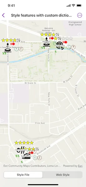
Toggle between the dictionary symbols from the web style and style file. Pan and zoom around the map to see the symbology from the chosen dictionary symbol style. The web style and style file are slightly different to each other to give a visual indication of the switch between the two.
How it works
- Create a
PortalItem, referring to aPortaland the item ID of the web style. - Based on the style selected:
- If the web style toggle has been selected, create a new
DictionarySymbolStylefrom the portal item usingDictionarySymbolStyle(portalItem:), and load it. - If the file style toggle has been selected, create a new
DictionarySymbolStyleusingDictionarySymbolStyle(url:).
- Create a new
DictionaryRenderer, providing the dictionary symbol style. - Apply the dictionary renderer to a feature layer.
- Add the feature layer to the map’s operational layers.
Relevant API
- DictionaryRenderer
- DictionarySymbolStyle
- Portal
- PortalItem
About the data
The data used in this sample is from a feature layer showing a subset of restaurants in Redlands, CA hosted as a feature service with attributes for rating, style, health score, and open hours.
The feature layer is symbolized using a dictionary renderer that displays a single symbol for all of these variables. The renderer uses symbols from a custom restaurant dictionary style created from a stylx file and a web style, available as items from ArcGIS Online, to show unique symbols based on several feature attributes. The symbols it contains were created using ArcGIS Pro. The logic used to apply the symbols comes from an Arcade script embedded in the stylx file (which is a SQLite database), along with a JSON string that defines expected attribute names and configuration properties.
Additional information
For information about creating your own custom dictionary style, see the open source dictionary renderer toolkit on GitHub.
Tags
dictionary, military, portal, portal item, renderer, style, stylx, unique value, visualization
Sample code
// Copyright 2023 Esri//// Licensed under the Apache License, Version 2.0 (the "License");// you may not use this file except in compliance with the License.// You may obtain a copy of the License at////   https://www.apache.org/licenses/LICENSE-2.0//// Unless required by applicable law or agreed to in writing, software// distributed under the License is distributed on an "AS IS" BASIS,// WITHOUT WARRANTIES OR CONDITIONS OF ANY KIND, either express or implied.// See the License for the specific language governing permissions and// limitations under the License.
import ArcGISimport SwiftUI
struct StyleFeaturesWithCustomDictionaryView: View {    /// The view model for the sample.    @StateObject private var model = Model()
    /// The current custom dictionary style selection.    @State private var dictionaryStyleSelection: CustomDictionaryStyle = .file
    var body: some View {        MapView(map: model.map)            .toolbar {                ToolbarItem(placement: .bottomBar) {                    // The picker to toggle between style file and web style.                    Picker("Dictionary Symbol Style", selection: $dictionaryStyleSelection) {                        ForEach(CustomDictionaryStyle.allCases, id: \.self) { style in                            Text(style.label)                        }                    }                    .pickerStyle(.segmented)                    .onChange(of: dictionaryStyleSelection) {                        // Update the feature layer with the correct dictionary renderer                        // on selection change.                        model.restaurantFeatureLayer.renderer = dictionaryStyleSelection == .web ? model.dictionaryRendererFromWebStyle : model.dictionaryRendererFromStyleFile                    }                }            }    }}
private extension StyleFeaturesWithCustomDictionaryView {    /// The view model for the sample.    class Model: ObservableObject {        /// A map with a topographic basemap centered on Esri in Redlands, CA.        let map: Map = {            let map = Map(basemapStyle: .arcGISTopographic)            map.initialViewpoint = Viewpoint(                latitude: 34.0543,                longitude: -117.1963,                scale: 1e4            )            return map        }()
        /// A feature layer with restaurants in Redlands, CA.        let restaurantFeatureLayer: FeatureLayer = {            let restaurantFeatureTable = ServiceFeatureTable(url: .redlandsRestaurants)            return FeatureLayer(featureTable: restaurantFeatureTable)        }()
        /// A dictionary renderer created from a custom symbol style dictionary file (.stylx) on local disk.        let dictionaryRendererFromStyleFile: DictionaryRenderer = {            // Create the dictionary symbol style from the style file URL.            let restaurantStyle = DictionarySymbolStyle(url: .restaurants)
            // Create the dictionary renderer from the dictionary symbol style.            return DictionaryRenderer(dictionarySymbolStyle: restaurantStyle)        }()
        /// A dictionary renderer created from a custom symbol style hosted on ArcGIS Online.        let dictionaryRendererFromWebStyle: DictionaryRenderer = {            // The create a portal item with the id of the online web style.            let restaurant = PortalItem(                portal: .arcGISOnline(connection: .anonymous),                id: .restaurantWebStyle            )
            // Create a dictionary symbol style from the web style portal item.            let restaurantStyle = DictionarySymbolStyle(portalItem: restaurant)
            // Create a dictionary renderer from the dictionary symbol style.            // Map the input fields in the feature layer to the dictionary symbol            // style's expected fields for symbols.            return DictionaryRenderer(                dictionarySymbolStyle: restaurantStyle,                symbologyFieldOverrides: ["healthgrade": "Inspection"]            )        }()
        init() {            // Add the feature layer with the dictionary renderer to the map.            restaurantFeatureLayer.renderer = dictionaryRendererFromStyleFile            map.addOperationalLayer(restaurantFeatureLayer)        }    }
    /// The custom dictionary symbol styles to choose from.    private enum CustomDictionaryStyle: CaseIterable {        case file, web
        /// A human-readable label for the custom dictionary style.        var label: String {            switch self {            case .file: return "Style File"            case .web: return "Web Style"            }        }    }}
private extension PortalItem.ID {    /// A portal item ID of a restaurant web style hosted on ArcGIS Online.    static var restaurantWebStyle: Self { Self("adee951477014ec68d7cf0ea0579c800")! }}
private extension URL {    /// A URL to the local restaurant symbol style dictionary file.    static var restaurants: URL {        Bundle.main.url(forResource: "Restaurant", withExtension: "stylx")!    }}
private extension URL {    /// A URL to an ArcGIS feature service with points representing restaurants in Redlands, CA.    static var redlandsRestaurants: URL {        URL(string: "https://services2.arcgis.com/ZQgQTuoyBrtmoGdP/arcgis/rest/services/Redlands_Restaurants/FeatureServer/0")!    }}