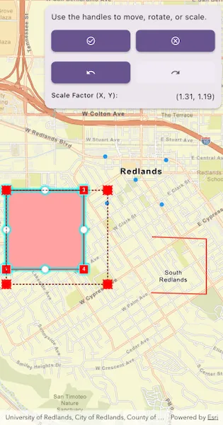
Use the geometry editor to see information about the geometry editor’s previewed geometry during an editing interaction.
Use case
The geometry editor can provide information about the geometry being created or edited during an interaction. This information can be used to give feedback to the user to show the effect of the interaction on the geometry.
How to use the sample
Tap a graphic to edit its geometry by moving, rotating, or scaling the geometry. During the interaction, information about the geometry will be displayed to provide feedback to the user.
Use the buttons in the settings view to undo or redo changes made to the geometry and the cancel and done buttons to discard and save changes, respectively.
How it works
- Create a
GeometryEditorand set it to theArcGISMapViewController.geometryEditor. - Add an event handler to listen to
GeometryEditor.onInteractionPreviewChanged.- This event can be used to get information on the state of the geometry during an interaction with the
GeometryEditorInteractionPreviewparameter.- The
previewGeometryrepresents the geometry’s state at that moment. - The
interactionTypecan be used to determine the type of interaction that is occurring (create,move,rotate,scale).
- The
- This event can be used to get information on the state of the geometry during an interaction with the
- Configure a
VertexToolwith anInteractionConfigurationand assign it toGeometryEditor.tool. - Start the
GeometryEditorusingGeometryEditor.startWithGeometry(Geometry)to edit the geometry of an identifiedGraphic.- To identify the
GraphicuseArcGISMapViewController.identifyGraphicsOverlay(...)and get the firstGraphicfrom theIdentifyGraphicsOverlayResult.graphicslist.
- To identify the
- Listen to
GeometryEditor.onCanUndoChangedandGeometryEditor.onCanRedoChangedto check if undo and redo are possible during an editing session. If possible, useGeometryEditor.undo()andGeometryEditor.redo(). - Call
GeometryEditor.stop()to finish the editing session and store theGraphic. TheGeometryEditordoes not automatically handle the visualization of a geometry output from an editing session. This must be done manually by propagating the geometry returned into aGraphicadded to aGraphicsOverlay.- To update the geometry underlying an existing
Graphicin theGraphicsOverlay:- Replace the existing
Graphic’sgeometryproperty with the geometry returned by theGeometryEditor.stop()method.
- Replace the existing
- To update the geometry underlying an existing
Relevant API
- Geometry
- GeometryEditor
- GeometryEditor.onInteractionPreviewChanged
- GeometryEditorInteractionPreview
- GeometryEditorInteractionType
- Graphic
- GraphicsOverlay
Additional information
The GeometryEditor.onInteractionPreviewChanged event fires continuously during an interaction, therefore it’s not recommended to use it as a trigger for resource intensive actions.
Tags
draw, edit, geometry editor, interaction preview
Sample code
// Copyright 2026 Esri//// Licensed under the Apache License, Version 2.0 (the "License");// you may not use this file except in compliance with the License.// You may obtain a copy of the License at////   https://www.apache.org/licenses/LICENSE-2.0//// Unless required by applicable law or agreed to in writing, software// distributed under the License is distributed on an "AS IS" BASIS,// WITHOUT WARRANTIES OR CONDITIONS OF ANY KIND, either express or implied.// See the License for the specific language governing permissions and// limitations under the License.//
import 'dart:async';import 'dart:math' as math;
import 'package:arcgis_maps/arcgis_maps.dart';import 'package:arcgis_maps_sdk_flutter_samples/common/common.dart';import 'package:flutter/material.dart';
class DisplayGeometryEditorInformationDuringInteraction extends StatefulWidget {  const DisplayGeometryEditorInformationDuringInteraction({super.key});
  @override  State<DisplayGeometryEditorInformationDuringInteraction> createState() =>      _DisplayGeometryEditorInformationDuringInteractionState();}
class _DisplayGeometryEditorInformationDuringInteractionState    extends State<DisplayGeometryEditorInformationDuringInteraction>    with SampleStateSupport {  // Create a controller for the map view.  final _mapViewController = ArcGISMapView.createController();
  // Create a geometry editor to edit selected graphics.  final _geometryEditor = GeometryEditor();
  // Create a graphics overlay to display editable geometries.  final _graphicsOverlay = GraphicsOverlay();
  // Keep stream subscriptions so they can be cancelled when the sample closes.  final _subscriptions = <StreamSubscription<dynamic>>[];  // A flag for when the map view is ready and controls can be used.  var _ready = false;
  // Track the graphic currently being edited.  Graphic? _editingGraphic;
  // Track the current editing state for the action controls.  var _geometryEditorIsStarted = false;
  // Track whether the undo action is currently available.  var _geometryEditorCanUndo = false;
  // Track whether the redo action is currently available.  var _geometryEditorCanRedo = false;
  // Store the current preview information text for display.  String? _interactionPreviewDescription;
  // Store the current preview value text for display.  String? _interactionPreviewValue;
  @override  void dispose() {    // Cancel geometry editor subscriptions before disposing the widget.    for (final subscription in _subscriptions) {      unawaited(subscription.cancel());    }
    super.dispose();  }
  @override  Widget build(BuildContext context) {    return Scaffold(      body: Stack(        children: [          Column(            children: [              Expanded(                // Add a map view to the widget tree and set a controller.                child: ArcGISMapView(                  controllerProvider: () => _mapViewController,                  onMapViewReady: onMapViewReady,                  onTap: onTap,                ),              ),            ],          ),          // Display the editing controls over the map.          Positioned(top: 10, right: 10, child: buildEditingPanel(context)),          // Display a progress indicator and prevent interaction until state is ready.          LoadingIndicator(visible: !_ready),        ],      ),    );  }
  void onMapViewReady() {    // Create a map with the streets basemap style.    final map = ArcGISMap.withBasemapStyle(BasemapStyle.arcGISStreets);    _mapViewController.arcGISMap = map;
    // Add graphics that can be selected and edited.    _graphicsOverlay.graphics.addAll(initialGraphics());    _mapViewController.graphicsOverlays.add(_graphicsOverlay);
    // Set the initial viewpoint over the editable geometries.    _mapViewController.setViewpoint(      Viewpoint.fromJsonString('''{"rotation":0.0,"scale":35000,"targetGeometry":{"spatialReference":{"wkid":3857},"x":-13045202.018086127,"y":4035612.571361517}}'''),    );
    // Configure the vertex tool to transform complete geometries only.    final configuration = InteractionConfiguration()      ..allowVertexCreation = false      ..allowMidVertexSelection = false      ..allowDeletingSelectedElement = false      ..allowVertexSelection = false      ..allowPartCreation = false;    _geometryEditor.tool = VertexTool()..configuration = configuration;
    // Listen for preview changes and update the feedback panel.    _subscriptions.add(      _geometryEditor.onInteractionPreviewChanged.listen(        updateInteractionPreview,      ),    );    // Listen for undo and redo changes to enable the toolbar buttons.    _subscriptions.add(      _geometryEditor.onCanUndoChanged.listen(        (canUndo) => setState(() => _geometryEditorCanUndo = canUndo),      ),    );    _subscriptions.add(      _geometryEditor.onCanRedoChanged.listen(        (canRedo) => setState(() => _geometryEditorCanRedo = canRedo),      ),    );    // Set the geometry editor to the map view controller.    _mapViewController.geometryEditor = _geometryEditor;
    // Set the ready state variable to true to enable the sample UI.    setState(() => _ready = true);  }
  Future<void> onTap(Offset localPosition) async {    // Ignore taps while editing is already in progress.    if (_geometryEditorIsStarted) return;
    // Identify a graphic to edit at the tapped location.    final results = await _mapViewController.identifyGraphicsOverlay(      _graphicsOverlay,      screenPoint: localPosition,      tolerance: 12,    );    if (results.graphics.isEmpty) return;
    // Start editing the identified graphic's geometry.    final identifiedGraphic = results.graphics.first;    final geometry = identifiedGraphic.geometry;    if (geometry == null) return;
    identifiedGraphic.isVisible = false;    _geometryEditor.startWithGeometry(geometry);    _geometryEditor.selectGeometry();
    setState(() {      _editingGraphic = identifiedGraphic;      _geometryEditorIsStarted = true;      _interactionPreviewDescription = null;      _interactionPreviewValue = null;    });  }
  void updateInteractionPreview(    GeometryEditorInteractionPreview? interactionPreview,  ) {    // Clear the preview panel when an interaction finishes.    if (interactionPreview == null) {      setState(() {        _interactionPreviewDescription = null;        _interactionPreviewValue = null;      });      return;    }
    // Select the feedback text based on the current interaction type.    switch (interactionPreview.interactionType) {      case GeometryEditorInteractionType.move:        setMovingGeometryLabel(interactionPreview);      case GeometryEditorInteractionType.rotate:        setRotationAngleLabel(interactionPreview);      case GeometryEditorInteractionType.scale:        setScaleFactorLabel(interactionPreview);      case GeometryEditorInteractionType.create:        setState(() {          _interactionPreviewDescription = 'Interaction:';          _interactionPreviewValue = 'Creating geometry';        });    }  }
  void setMovingGeometryLabel(    GeometryEditorInteractionPreview interactionPreview,  ) {    // Get the center point of the preview geometry.    final previewCenter = interactionPreview.previewGeometry.extent.center;
    // Update the feedback label with the preview center point.    setState(() {      _interactionPreviewDescription = 'Center (X, Y):';      _interactionPreviewValue =          '(${previewCenter.x.toStringAsFixed(2)}, '          '${previewCenter.y.toStringAsFixed(2)})';    });  }
  void setRotationAngleLabel(    GeometryEditorInteractionPreview interactionPreview,  ) {    // Get the current geometry and its center point for the rotation calculation.    final originalGeometry = _geometryEditor.geometry;    if (originalGeometry == null) return;
    final center = originalGeometry.extent.center;
    // Get comparable points from the original and preview geometries.    final originalPoint = pointForRotation(originalGeometry, center);    final previewPoint = pointForRotation(      interactionPreview.previewGeometry,      center,    );    if (originalPoint == null || previewPoint == null) return;
    // Calculate the clockwise rotation angle in degrees.    final vector1X = originalPoint.x - center.x;    final vector2X = previewPoint.x - center.x;    final vector1Y = originalPoint.y - center.y;    final vector2Y = previewPoint.y - center.y;    final cross = vector1X * vector2Y - vector1Y * vector2X;    final dot = vector1X * vector2X + vector1Y * vector2Y;    final angle = math.atan2(cross, dot) * (180.0 / math.pi);    final clockwiseNormalized = ((-angle % 360) + 360) % 360;
    // Update the feedback label with the rotation angle.    setState(() {      _interactionPreviewDescription = 'Rotation Angle (degrees):';      _interactionPreviewValue = clockwiseNormalized.toStringAsFixed(2);    });  }
  void setScaleFactorLabel(    GeometryEditorInteractionPreview interactionPreview,  ) {    // Get the current geometry extents for the scale calculation.    final originalGeometry = _geometryEditor.geometry;    if (originalGeometry == null) return;
    final originalExtent = originalGeometry.extent;    final previewExtent = interactionPreview.previewGeometry.extent;    if (originalExtent.width == 0 || originalExtent.height == 0) return;
    // Calculate the X and Y scale factors.    final scaleX = previewExtent.width / originalExtent.width;    final scaleY = previewExtent.height / originalExtent.height;
    // Update the feedback label with the scale factors.    setState(() {      _interactionPreviewDescription = 'Scale Factor (X, Y):';      _interactionPreviewValue =          '(${scaleX.toStringAsFixed(2)}, ${scaleY.toStringAsFixed(2)})';    });  }
  ArcGISPoint? pointForRotation(Geometry geometry, ArcGISPoint center) {    // Get a stable non-center point from multipart and multipoint geometries.    switch (geometry) {      case final Multipart multipart:        return multipart.parts.first.endPoint;      case final Multipoint multipoint:        return multipoint.points.firstWhere(          (point) => point.x != center.x || point.y != center.y,        );      default:        return null;    }  }
  void stopAndSaveEdits() {    // Stop the geometry editor and save the edited geometry back to the graphic.    final geometry = _geometryEditor.stop();    if (geometry != null && _editingGraphic != null) {      _editingGraphic!        ..geometry = geometry        ..isVisible = true;    }
    // Reset the editing state.    setState(() {      _editingGraphic = null;      _geometryEditorIsStarted = false;      _interactionPreviewDescription = null;      _interactionPreviewValue = null;    });  }
  void stopAndDiscardEdits() {    // Stop the geometry editor and restore the original graphic.    _geometryEditor.stop();    _editingGraphic?.isVisible = true;
    // Reset the editing state.    setState(() {      _editingGraphic = null;      _geometryEditorIsStarted = false;      _interactionPreviewDescription = null;      _interactionPreviewValue = null;    });  }
  Widget buildEditingPanel(BuildContext context) {    // Build a compact panel for editing actions and interaction feedback.    return Card(      child: Padding(        padding: const EdgeInsets.all(12),        child: ConstrainedBox(          constraints: const BoxConstraints(maxWidth: 300),          child: Column(            mainAxisSize: MainAxisSize.min,            crossAxisAlignment: CrossAxisAlignment.stretch,            spacing: 10,            children: [              Text(                _geometryEditorIsStarted                    ? 'Use the handles to move, rotate, or scale.'                    : 'Tap a graphic to start the geometry editor.',                style: Theme.of(context).textTheme.bodyMedium,              ),              if (_geometryEditorIsStarted) ...[                // Add buttons to save, discard, undo, and redo edits.                Row(                  spacing: 10,                  children: [                    Expanded(                      child: Tooltip(                        message: 'Save edits',                        child: ElevatedButton(                          onPressed: stopAndSaveEdits,                          child: const Icon(Icons.check_circle_outline),                        ),                      ),                    ),                    Expanded(                      child: Tooltip(                        message: 'Discard edits',                        child: ElevatedButton(                          onPressed: stopAndDiscardEdits,                          child: const Icon(Icons.cancel_outlined),                        ),                      ),                    ),                  ],                ),                Row(                  spacing: 10,                  children: [                    Expanded(                      child: Tooltip(                        message: 'Undo',                        child: ElevatedButton(                          onPressed: _geometryEditorCanUndo                              ? _geometryEditor.undo                              : null,                          child: const Icon(Icons.undo),                        ),                      ),                    ),                    Expanded(                      child: Tooltip(                        message: 'Redo',                        child: ElevatedButton(                          onPressed: _geometryEditorCanRedo                              ? _geometryEditor.redo                              : null,                          child: const Icon(Icons.redo),                        ),                      ),                    ),                  ],                ),                if (_interactionPreviewDescription != null &&                    _interactionPreviewValue != null)                  // Display information about the current interaction preview.                  Row(                    crossAxisAlignment: CrossAxisAlignment.start,                    spacing: 8,                    children: [                      Text(                        _interactionPreviewDescription!,                        style: Theme.of(context).textTheme.labelMedium,                      ),                      Expanded(                        child: Text(                          _interactionPreviewValue!,                          textAlign: TextAlign.end,                        ),                      ),                    ],                  ),              ],            ],          ),        ),      ),    );  }
  List<Graphic> initialGraphics() {    // Create symbols for each editable geometry type.    final lineSymbol = SimpleLineSymbol(color: Colors.red, width: 2);    final markerSymbol = SimpleMarkerSymbol(color: Colors.blue);
    // Create a polygon, polyline, and multipoint in Redlands, California.    final redlandsPolygon = Geometry.fromJsonString('''{"rings":[[[-13046991.222211758,4034618.5047884779],[-13046991.222211758,4035962.0723415823],[-13045677.652220398,4035962.0723415823],[-13045677.652220398,4034618.5047884779],[-13046991.222211758,4034618.5047884779]]],"spatialReference":{"wkid":3857}}''');    final redlandsPolyline = Geometry.fromJsonString('''{"paths":[[[-13044533.805088846,4034221.5100018946],[-13043597.938505623,4034197.1337576872],[-13043597.938505623,4035135.572073034],[-13044522.634505576,4035170.5449295067]]],"spatialReference":{"wkid":3857}}''');    final redlandsMultipoint = Geometry.fromJsonString('''{"points":[[-13045283.292102993,4035739.1925106063],[-13045314.922186911,4036533.8852012255],[-13044798.24723932,4036138.7808295386],[-13044354.514637273,4035719.3623426706],[-13044281.57229173,4036473.0999132735]],"spatialReference":{"wkid":3857}}''');
    // Return graphics for each editable geometry.    return [      Graphic(geometry: redlandsMultipoint, symbol: markerSymbol),      Graphic(geometry: redlandsPolygon, symbol: lineSymbol),      Graphic(geometry: redlandsPolyline, symbol: lineSymbol),    ];  }}