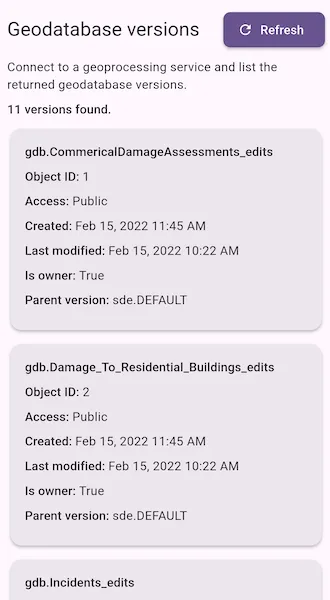
Connect to a service and list versions of the geodatabase.
Use case
As part of a multi-user editing scenario, you can check with the server to see how many versions of the geodatabase are outstanding before syncing.
How to use the sample
When the sample loads, a list of geodatabase versions and their properties is displayed. Tap Refresh to run the geoprocessing task again and reload the latest version information from the service.
How it works
- Create a
GeoprocessingTaskthat points to aGPServerwith aListVersionstask. - Use the task to create the default
GeoprocessingParameters. - Create a
GeoprocessingJobfrom the parameters and run it. - Get the
GeoprocessingResultfrom the completed job. - Read the
Versionsoutput parameter asGeoprocessingFeatures. - Convert each returned feature’s attributes into displayable version metadata.
Relevant API
- GeoprocessingFeatures
- GeoprocessingJob
- GeoprocessingParameters
- GeoprocessingResult
- GeoprocessingTask
About the data
The sample uses a sample geoprocessing service hosted on ArcGIS Online.
Additional information
ArcGIS Server does not include a geoprocessing service for listing geodatabase versions. You must configure one using the steps defined in Geoprocessing service example: list, create, and delete geodatabase versions in the ArcMap documentation.
Tags
conflict resolution, data management, database, multi-user, sync, version
Sample code
// Copyright 2026 Esri//// Licensed under the Apache License, Version 2.0 (the "License");// you may not use this file except in compliance with the License.// You may obtain a copy of the License at////   https://www.apache.org/licenses/LICENSE-2.0//// Unless required by applicable law or agreed to in writing, software// distributed under the License is distributed on an "AS IS" BASIS,// WITHOUT WARRANTIES OR CONDITIONS OF ANY KIND, either express or implied.// See the License for the specific language governing permissions and// limitations under the License.//
import 'dart:async';import 'package:arcgis_maps/arcgis_maps.dart';import 'package:arcgis_maps_sdk_flutter_samples/common/common.dart';import 'package:flutter/material.dart';import 'package:intl/intl.dart';
class ListGeodatabaseVersions extends StatefulWidget {  const ListGeodatabaseVersions({super.key});
  @override  State<ListGeodatabaseVersions> createState() =>      _ListGeodatabaseVersionsState();}
class _ListGeodatabaseVersionsState extends State<ListGeodatabaseVersions>    with SampleStateSupport {  // A geoprocessing task to list geodatabase versions from a sample service.  final _geoprocessingTask = GeoprocessingTask(    uri: Uri.parse(      'https://sampleserver6.arcgisonline.com/arcgis/rest/services/'      'GDBVersions/GPServer/ListVersions',    ),  );
  // The geoprocessing job created to list versions. Stored here so it can be  // cancelled if the widget is disposed.  GeoprocessingJob? _job;
  // A flag to indicate whether the geoprocessing task is currently running.  var _isLoading = false;
  // A message to display if an error occurs while loading versions.  var _errorMessage = '';
  // The list of geodatabase versions returned by the geoprocessing task.  var _versions = <_GeodatabaseVersionInfo>[];
  @override  void initState() {    super.initState();    // Load the versions when the widget is first created.    _loadVersions().ignore();  }
  @override  void dispose() {    // Cancel the geoprocessing job if it's still running when the widget is disposed.    _job?.cancel().ignore();    super.dispose();  }
  // Build the UI for the sample, showing a list of geodatabase versions and  // a button to refresh the list.  @override  Widget build(BuildContext context) {    return Scaffold(      body: SafeArea(        minimum: const EdgeInsets.all(12),        child: Stack(          children: [            Column(              crossAxisAlignment: CrossAxisAlignment.start,              spacing: 8,              children: [                // A row with the title of the sample and a button to refresh                // the list of versions.                Row(                  children: [                    Expanded(                      child: Text(                        'Geodatabase versions',                        style: Theme.of(context).textTheme.titleLarge,                      ),                    ),                    ElevatedButton.icon(                      onPressed: _isLoading ? null : _loadVersions,                      icon: const Icon(Icons.refresh),                      label: const Text('Refresh'),                    ),                  ],                ),                // A description of the sample and a count of how many versions have been loaded.                Text(                  'Connect to a geoprocessing service and list the returned geodatabase versions.',                  style: Theme.of(context).textTheme.bodyMedium,                ),                // Show the number of versions loaded, or a message if no versions have been loaded yet.                Text(                  _versions.isEmpty                      ? 'No versions loaded.'                      : '${_versions.length} versions found.',                  style: Theme.of(context).textTheme.titleSmall,                ),                // Show an error message if one exists.                if (_errorMessage.isNotEmpty) ...[                  Text(                    _errorMessage,                    style: Theme.of(context).textTheme.customErrorStyle,                  ),                ],                // Show the list of versions in an expanded widget to fill available space.                Expanded(child: _buildVersionList()),              ],            ),            LoadingIndicator(visible: _isLoading, text: 'Listing versions...'),          ],        ),      ),    );  }
  // Build a list view to display the geodatabase versions. If no versions have  // been loaded yet, show a message prompting the user to refresh the list.  Widget _buildVersionList() {    if (_versions.isEmpty) {      return ListView(        children: const [          Card(            child: Padding(              padding: EdgeInsets.all(16),              child: Text(                'Tap Refresh to run the geoprocessing task and view the geodatabase versions returned by the service.',              ),            ),          ),        ],      );    }    // Build a list view of cards, one for each geodatabase version.    // Each card shows information about the version,    // such as its name, access level, creation date, and other relevant details.    return RefreshIndicator(      onRefresh: _loadVersions,      child: ListView.separated(        itemCount: _versions.length,        separatorBuilder: (_, _) => const SizedBox(height: 8),        itemBuilder: (context, index) {          final version = _versions[index];          return _VersionCard(version: version);        },      ),    );  }
  // Load the geodatabase versions by running the geoprocessing task.  Future<void> _loadVersions() async {    // If a load is already in progress, do nothing.    if (_isLoading) return;
    GeoprocessingJob? activeJob;    setState(() {      _isLoading = true;      _errorMessage = '';    });
    try {      // Create default parameters for the geoprocessing task.      final parameters = await _geoprocessingTask.createDefaultParameters();
      // Create a job to execute the task with the parameters.      final job = _geoprocessingTask.createJob(parameters);      activeJob = job;
      // Store the job so it can be cancelled if the widget is disposed before it completes.      _job = job;
      // Run the job and wait for the result.      final result = await job.run();
      // Get the "Versions" output from the result, which should be a feature set.      final output = result.outputs['Versions'];      if (output is! GeoprocessingFeatures) {        throw StateError(          'The geoprocessing result did not include a Versions feature set.',        );      }      // Load the features from the output if they haven't been loaded already.      if (output.features == null) {        await output.fetchOutputFeatures();      }
      final featureSet = output.features;      if (featureSet == null) {        throw StateError('The Versions output did not contain any features.');      }
      // Convert the features to _GeodatabaseVersionInfo objects.      final versions =          featureSet              .features()              .map(                (feature) =>                    _GeodatabaseVersionInfo.fromAttributes(feature.attributes),              )              .whereType<_GeodatabaseVersionInfo>()              .toList()            ..sort((a, b) {              final objectIdCompare = (a.objectId ?? 1 << 30).compareTo(                b.objectId ?? 1 << 30,              );              return objectIdCompare != 0                  ? objectIdCompare                  : a.name.compareTo(b.name);            });
      setState(() => _versions = versions);    } on ArcGISException catch (e) {      setState(() => _errorMessage = e.message);    } on Exception catch (e) {      setState(() => _errorMessage = e.toString());    } finally {      if (identical(_job, activeJob)) {        _job = null;        setState(() => _isLoading = false);      }    }  }}
// A card widget to display information about a geodatabase version.class _VersionCard extends StatelessWidget {  const _VersionCard({required this.version});
  // The geodatabase version to display information about.  final _GeodatabaseVersionInfo version;
  @override  Widget build(BuildContext context) {    // Build a card to display the version information.    return Card(      child: Padding(        padding: const EdgeInsets.all(16),        child: SelectionArea(          child: Column(            crossAxisAlignment: CrossAxisAlignment.start,            children: [              Text(version.name, style: Theme.of(context).textTheme.titleSmall),              const SizedBox(height: 8),              _InfoRow(                label: 'Object ID',                value: version.objectId?.toString() ?? 'Unavailable',              ),              _InfoRow(label: 'Access', value: version.access),              _InfoRow(label: 'Created', value: version.createdText),              _InfoRow(label: 'Last modified', value: version.lastModifiedText),              _InfoRow(label: 'Is owner', value: version.isOwnerText),              _InfoRow(                label: 'Parent version',                value: version.parentVersionName,              ),              if (version.description.isNotEmpty)                _InfoRow(label: 'Description', value: version.description),            ],          ),        ),      ),    );  }}
// A widget to display a label and value in a consistent style, used to show// information about a geodatabase version in the _VersionCard.class _InfoRow extends StatelessWidget {  const _InfoRow({required this.label, required this.value});
  final String label;  final String value;
  @override  Widget build(BuildContext context) {    return Padding(      padding: const EdgeInsets.only(bottom: 8),      child: RichText(        text: TextSpan(          style: Theme.of(context).textTheme.bodyMedium,          children: [            TextSpan(              text: '$label: ',              style: Theme.of(context).textTheme.titleSmall,            ),            TextSpan(text: value),          ],        ),      ),    );  }}
// A class to hold information about a geodatabase version,// extracted from the attributes of a geoprocessing result feature.class _GeodatabaseVersionInfo {  _GeodatabaseVersionInfo({    required this.name,    required this.access,    required this.created,    required this.description,    required this.isOwner,    required this.lastModified,    required this.objectId,    required this.parentVersionName,  });
  final String name;  final String access;  final DateTime? created;  final String description;  final String isOwner;  final DateTime? lastModified;  final int? objectId;  final String parentVersionName;
  static final _dateFormatter = DateFormat.yMMMd().add_jm();
  String get createdText => _formatDate(created);
  String get isOwnerText => isOwner.isEmpty ? 'Unavailable' : isOwner;
  String get lastModifiedText => _formatDate(lastModified);
  static _GeodatabaseVersionInfo? fromAttributes(    Map<String, Object?> attributes,  ) {    final name = _stringValue(attributes, 'name');    if (name.isEmpty) {      return null;    }
    return _GeodatabaseVersionInfo(      name: name,      access: _stringValue(attributes, 'access', fallback: 'Unavailable'),      created: _dateValue(attributes, 'created'),      description: _stringValue(attributes, 'description'),      isOwner: _stringValue(attributes, 'isowner', fallback: 'Unavailable'),      lastModified: _dateValue(attributes, 'lastmodified'),      objectId: _intValue(attributes, 'objectid'),      parentVersionName: _stringValue(        attributes,        'parentversionname',        fallback: 'Unavailable',      ),    );  }
  static DateTime? _dateValue(Map<String, Object?> attributes, String key) {    final value = _rawValue(attributes, key);    if (value is DateTime) {      return value.toLocal();    }    if (value is num) {      return DateTime.fromMillisecondsSinceEpoch(value.toInt()).toLocal();    }    if (value is String && value.isNotEmpty) {      return DateTime.tryParse(value)?.toLocal();    }    return null;  }
  static String _formatDate(DateTime? value) {    return value == null ? 'Unavailable' : _dateFormatter.format(value);  }
  static int? _intValue(Map<String, Object?> attributes, String key) {    final value = _rawValue(attributes, key);    if (value is int) {      return value;    }    if (value is num) {      return value.toInt();    }    if (value is String) {      return int.tryParse(value);    }    return null;  }
  static Object? _rawValue(Map<String, Object?> attributes, String key) {    final normalizedKey = key.toLowerCase();    for (final entry in attributes.entries) {      if (entry.key.toLowerCase() == normalizedKey) {        return entry.value;      }    }    return null;  }
  static String _stringValue(    Map<String, Object?> attributes,    String key, {    String fallback = '',  }) {    final value = _rawValue(attributes, key);    if (value == null) {      return fallback;    }    final text = value.toString().trim();    return text.isEmpty ? fallback : text;  }}