Display a WMS layer using a WMS service URL.
Use case
WMS is an OGC standard for displaying maps from images that are dynamically-generated on a web server. WMS is particularly useful for data that changes frequently, contains cartographically complex detail, or requires an open source data standard.
How to use the sample
The map will load automatically when the sample starts.
How it works
- Create a
WmsLayerspecifying the URL of the service and the names of layers you want to display.- Note: The name comes from the ‘Name’ property, not the ‘Title’ property. On many services, the title is human-readable while the name is a numeric identifier.
- Add the layer to the map as an operational layer with
map.getOperationalLayers().add(wmsLayer).
Relevant API
- ArcGISMap
- MapView
- WmsLayer
About the data
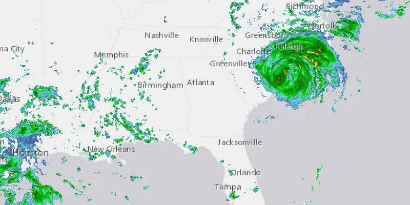
This sample uses a U.S. National Weather Service radar map. Because WMS services generate map images on-the-fly, this layer is always up-to-date with the latest NOAA nowCOAST real-time coastal observations, forecasts, and warnings.
Tags
OGC, web map service, WMS
Sample code
WmsLayerUrlSample.java
/* * Copyright 2017 Esri. * * Licensed under the Apache License, Version 2.0 (the "License"); you may not * use this file except in compliance with the License. You may obtain a copy of * the License at * * http://www.apache.org/licenses/LICENSE-2.0 * * Unless required by applicable law or agreed to in writing, software * distributed under the License is distributed on an "AS IS" BASIS, WITHOUT * WARRANTIES OR CONDITIONS OF ANY KIND, either express or implied. See the * License for the specific language governing permissions and limitations under * the License. */
package com.esri.samples.wms_layer_url;
import java.util.Collections;import java.util.List;
import javafx.application.Application;import javafx.geometry.Pos;import javafx.scene.Scene;import javafx.scene.control.Alert;import javafx.scene.control.ProgressIndicator;import javafx.scene.layout.StackPane;import javafx.stage.Stage;
import com.esri.arcgisruntime.ArcGISRuntimeEnvironment;import com.esri.arcgisruntime.geometry.Envelope;import com.esri.arcgisruntime.geometry.SpatialReferences;import com.esri.arcgisruntime.layers.WmsLayer;import com.esri.arcgisruntime.loadable.LoadStatus;import com.esri.arcgisruntime.mapping.ArcGISMap;import com.esri.arcgisruntime.mapping.BasemapStyle;import com.esri.arcgisruntime.mapping.view.MapView;
public class WmsLayerUrlSample extends Application {
  private MapView mapView;  private WmsLayer wmsLayer; // keep loadable in scope to avoid garbage collection
  @Override  public void start(Stage stage) {
    try {      // create stack pane and application scene      StackPane stackPane = new StackPane();      Scene scene = new Scene(stackPane);
      // set title, size, and add scene to stage      stage.setTitle("WMS Layer URL Sample");      stage.setWidth(800);      stage.setHeight(700);      stage.setScene(scene);      stage.show();
      // authentication with an API key or named user is required to access basemaps and other location services      String yourAPIKey = System.getProperty("apiKey");      ArcGISRuntimeEnvironment.setApiKey(yourAPIKey);
      // create a map with the light gray basemap style      ArcGISMap map = new ArcGISMap(BasemapStyle.ARCGIS_LIGHT_GRAY);
      // create a map view and set the map to it      mapView = new MapView();      mapView.setMap(map);
      // start zoomed in over the US      mapView.setViewpointGeometryAsync(new Envelope(-19195297.778679, 512343.939994, -3620418.579987, 8658913.035426, 0.0, 0.0, SpatialReferences.getWebMercator()));
      // create a WMS layer      List<String> wmsLayerNames = Collections.singletonList("base_reflectivity_mosaic");      String url = "https://nowcoast.noaa.gov/geoserver/observations/weather_radar/wms";      wmsLayer = new WmsLayer(url, wmsLayerNames);
      // load the layer and add it as an operational layer      wmsLayer.loadStatusProperty().addListener((observable, oldValue, newValue) -> {        if (newValue == LoadStatus.FAILED_TO_LOAD) {          new Alert(Alert.AlertType.ERROR, "Failed to load WMS layer.\n" +            wmsLayer.loadErrorProperty().get().getCause().getMessage()).show();        }      });      map.getOperationalLayers().add(wmsLayer);
      // create a progress indicator and show it while the layer is loading      var progressIndicator = new ProgressIndicator();      progressIndicator.setMaxSize(25, 25);      progressIndicator.visibleProperty().bind(wmsLayer.loadStatusProperty().isEqualTo(LoadStatus.LOADING));
      // add the map view to stack pane      stackPane.getChildren().addAll(mapView, progressIndicator);      StackPane.setAlignment(progressIndicator, Pos.CENTER);    } catch (Exception e) {      // on any error, display the stack trace.      e.printStackTrace();    }  }
  /**   * Stops and releases all resources used in application.   */  @Override  public void stop() {
    if (mapView != null) {      mapView.dispose();    }  }
  /**   * Opens and runs application.   *   * @param args arguments passed to this application   */  public static void main(String[] args) {
    Application.launch(args);  }
}