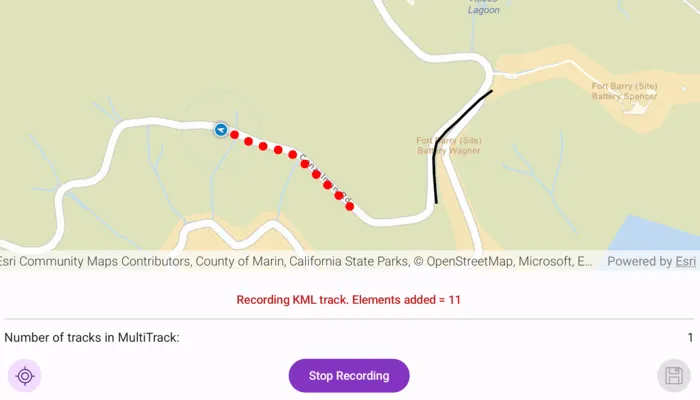
Create, save and preview a KML multi-track, captured from a location data source.
Use case
When capturing location data for outdoor activities such as hiking or skiing, it can be useful to record and share your path. This sample demonstrates how you can collect individual KML tracks during a navigation session, then combine and export them as a KML multi-track.
How to use the sample
Tap Start Navigation to begin moving along a simulated trail. Tap Record Track to start recording your current path. Tap Stop Recording to end recording and capture a KML track. Repeat steps to capture multiple KML tracks in a single session. Tap the Save button to save your recorded tracks as a .kmz file to local storage. Then load the created .kmz file containing your KML multi-track to view all created tracks on the map.
How it works
- Create an
ArcGISMapwith a basemap and aGraphicsOverlayto display the path geometry for your navigation route. - Create a
SimulatedLocationDataSourceto drive theLocationDisplay. - As you receive
Locationupdates, add each point to a list ofKmlTrackElementobjects while recording. - On recording stopped, create a
KmlTrackusing one or moreKmlTrackElementobjects. - Combine one or more
KmlTrackobjects into aKmlMultiTrack. - Save the
KmlMultiTrackinside aKmlDocument, then export the document to a.kmzfile. - Load the saved
.kmzfile into aKmlDatasetand locate theKmlDocumentin the dataset’srootNodes. From the document’schildNodesget theKmlPlacemarkand retrieve theKmlMultiTrackgeometry. - Retrieve the geometry of each track in the
KmlMultiTrackby iterating through the list of tracks and obtaining the respectiveKmlTrack.geometry.
Relevant API
- KmlDataset
- KmlDocument
- KmlMultiTrack
- KmlPlacemark
- KmlTrack
- LocationDisplay
- SimulatedLocationDataSource
Additional information
This sample uses the GeoView-Compose Toolkit module to be able to implement a composable MapView.
Tags
export, geoview-compose, hiking, kml, kmz, multi-track, record, track
Sample code
/* Copyright 2025 Esri * * Licensed under the Apache License, Version 2.0 (the "License"); * you may not use this file except in compliance with the License. * You may obtain a copy of the License at * *    http://www.apache.org/licenses/LICENSE-2.0 * * Unless required by applicable law or agreed to in writing, software * distributed under the License is distributed on an "AS IS" BASIS, * WITHOUT WARRANTIES OR CONDITIONS OF ANY KIND, either express or implied. * See the License for the specific language governing permissions and * limitations under the License. * */
package com.esri.arcgismaps.sample.createkmlmultitrack.components
import android.app.Applicationimport android.widget.Toastimport androidx.compose.runtime.getValueimport androidx.compose.runtime.mutableStateOfimport androidx.compose.runtime.setValueimport androidx.lifecycle.AndroidViewModelimport androidx.lifecycle.viewModelScopeimport com.arcgismaps.Colorimport com.arcgismaps.geometry.Geometryimport com.arcgismaps.geometry.GeometryEngineimport com.arcgismaps.geometry.Multipointimport com.arcgismaps.geometry.Pointimport com.arcgismaps.geometry.Polylineimport com.arcgismaps.location.Locationimport com.arcgismaps.location.LocationDisplayAutoPanModeimport com.arcgismaps.location.SimulatedLocationDataSourceimport com.arcgismaps.location.SimulationParametersimport com.arcgismaps.mapping.ArcGISMapimport com.arcgismaps.mapping.BasemapStyleimport com.arcgismaps.mapping.kml.KmlAltitudeModeimport com.arcgismaps.mapping.kml.KmlDatasetimport com.arcgismaps.mapping.kml.KmlDocumentimport com.arcgismaps.mapping.kml.KmlMultiTrackimport com.arcgismaps.mapping.kml.KmlPlacemarkimport com.arcgismaps.mapping.kml.KmlTrackimport com.arcgismaps.mapping.kml.KmlTrackElementimport com.arcgismaps.mapping.symbology.SimpleLineSymbolimport com.arcgismaps.mapping.symbology.SimpleLineSymbolStyleimport com.arcgismaps.mapping.symbology.SimpleMarkerSymbolimport com.arcgismaps.mapping.symbology.SimpleMarkerSymbolStyleimport com.arcgismaps.mapping.view.Graphicimport com.arcgismaps.mapping.view.GraphicsOverlayimport com.arcgismaps.mapping.view.LocationDisplayimport com.arcgismaps.toolkit.geoviewcompose.MapViewProxyimport com.esri.arcgismaps.sample.createkmlmultitrack.Rimport com.esri.arcgismaps.sample.sampleslib.components.MessageDialogViewModelimport kotlinx.coroutines.Jobimport kotlinx.coroutines.cancelAndJoinimport kotlinx.coroutines.flow.MutableStateFlowimport kotlinx.coroutines.flow.asStateFlowimport kotlinx.coroutines.launchimport java.io.Fileimport java.time.Instant
class CreateKMLMultiTrackViewModel(application: Application) : AndroidViewModel(application) {    private val provisionPath: String by lazy {        application.getExternalFilesDir(null)?.path.toString() +                File.separator + application.getString(R.string.create_kml_multi_track_app_name)    }
    // Create a message dialog view model for handling error messages    val messageDialogVM = MessageDialogViewModel()
    // This should be passed to the composable MapView    val mapViewProxy = MapViewProxy()
    // Display a map with a street basemap style    val arcGISMap by mutableStateOf(ArcGISMap(BasemapStyle.ArcGISStreets))
    // Overlay to display kml tracks and location points    val graphicsOverlay = GraphicsOverlay()
    // Marker symbol to display KmlTrackElements    private val locationSymbol = SimpleMarkerSymbol(        style = SimpleMarkerSymbolStyle.Circle,        color = Color.red,        size = 10f    )
    // Line symbol to display KmlTrack    private val lineSymbol = SimpleLineSymbol(        style = SimpleLineSymbolStyle.Solid,        color = Color.black,        width = 3f    )
    // Observe the list of KML track elements being added when recording a KML track    private var _kmlTrackElements = MutableStateFlow<List<KmlTrackElement>>(listOf())    val kmlTrackElements = _kmlTrackElements.asStateFlow()
    // Observe the list of KML tracks being added for the multi track    private var _kmlTracks = MutableStateFlow<List<KmlTrack>>(listOf())    val kmlTracks = _kmlTracks.asStateFlow()
    // Enables the recenter button when not in navigation autopan    var isRecenterButtonEnabled by mutableStateOf(false)        private set
    // Updates UI to reflect recording buttons and text information    var isRecordingTrack by mutableStateOf(false)        private set
    // Updates the UI to display the tracks of the local .kmz file    var isShowTracksFromFileEnabled by mutableStateOf(false)        private set
    // Runs the location display simulation and is canceled when completed.    private var locationDisplayJob: Job? = null
    // Default location display object, which is updated by rememberLocationDisplay    private var locationDisplay: LocationDisplay = LocationDisplay()
    // Sets the location display    fun setLocationDisplay(locationDisplay: LocationDisplay) {        this.locationDisplay = locationDisplay    }
    /**     * Loads the hiking path polyline and starts a simulation down a path.     * Updates the navigation autopan buttons based on state, and calls [addTrackElement]     * with the current simulation [Location] when [isRecordingTrack] is enabled.     */    suspend fun startNavigation() {        // Get the hiking path geometry        val routeGeometry = Geometry.fromJsonOrNull(            json = getApplication<Application>().getString(R.string.Coastal_Trail)        ) as Polyline        // Create a simulated location data source from json data        // with simulation parameters to set a consistent velocity        val simulatedLocationDataSource = SimulatedLocationDataSource(            polyline = routeGeometry,            parameters = SimulationParameters(                startTime = Instant.now(),                velocity = 25.0,                horizontalAccuracy = 0.0,                verticalAccuracy = 0.0            )        )        // Set the map's initial viewpoint        mapViewProxy.setViewpointGeometry(routeGeometry, 25.0)        // Update sample UI state        isShowTracksFromFileEnabled = false        // Create a new job with the following coroutines        locationDisplayJob = with(viewModelScope) {            launch {                // Set the simulated location data source as the location data source for this app                locationDisplay.dataSource = simulatedLocationDataSource
                // Start the location data source                locationDisplay.dataSource.start().onFailure {                    messageDialogVM.showMessageDialog(                        title = "Error starting location data source",                        description = it.message.toString()                    )                }
                // Set the auto pan to navigation mode                locationDisplay.setAutoPanMode(LocationDisplayAutoPanMode.Navigation)            }            launch {                // Automatically enable recenter button when navigation pan is disabled                locationDisplay.autoPanMode.collect {                    when (it) {                        LocationDisplayAutoPanMode.Off -> isRecenterButtonEnabled = true                        LocationDisplayAutoPanMode.Navigation -> isRecenterButtonEnabled = false                        else -> {}                    }                }            }            launch {                // Listen for changes in location                locationDisplay.location.collect {                    it?.let { location ->                        if (isRecordingTrack) {                            addTrackElement(location.position)                        }                    }                }            }        }    }
    /**     * When recording is enabled, add the given [locationPoint] to the list     * of [kmlTrackElements] and display the graphic on the map.     */    private fun addTrackElement(locationPoint: Point) {        // Add a new element to the state flow        _kmlTrackElements.value += KmlTrackElement(            coordinate = locationPoint,            instant = Instant.now(),            angle = null        )        // Add a graphic at the location's position        graphicsOverlay.graphics.add(            Graphic(                geometry = locationPoint,                symbol = locationSymbol            )        )    }
    /**     * Enables recording state to collect position values from the location data source.     */    fun startRecordingKmlTrack() {        isRecordingTrack = true        _kmlTrackElements.value = listOf()    }
    /**     * Disables recording to create a new [KmlTrack] and display the track graphic on the map.     */    fun stopRecordingKmlTrack() {        if (_kmlTrackElements.value.isEmpty())            return messageDialogVM.showMessageDialog(                title = "Empty track elements",                description = "Cannot create a KmlTrack with 0 KmlTrackElements"            )
        _kmlTracks.value += KmlTrack(            elements = _kmlTrackElements.value,            altitudeMode = KmlAltitudeMode.RelativeToGround        )
        displayKmlTracks()        isRecordingTrack = false    }
    /**     * Display polylines on the map representing all the recorded KML tracks.     */    private fun displayKmlTracks() {        graphicsOverlay.graphics.clear()        _kmlTracks.value.forEach { kmlTrack ->            // Get the map's spacial reference            val mapSpatialReference = arcGISMap.spatialReference                ?: return messageDialogVM.showMessageDialog("Error retrieving spacial reference")            // Set the KML geometry to use the same projection            val multipoint = (kmlTrack.geometry as Multipoint)            val polyline = GeometryEngine.projectOrNull(                geometry = Polyline(multipoint.points),                spatialReference = mapSpatialReference            ) ?: return messageDialogVM.showMessageDialog("Error converting geometry spacial reference")            // Add the polyline graphic to the map            graphicsOverlay.graphics.add(Graphic(geometry = polyline, symbol = lineSymbol))        }    }
    /**     * Exports the [KmlMultiTrack] as a kmz file to local storage.     */    fun exportKmlMultiTrack() {        // Create a default KML document which will export file to device        val kmlDocument = KmlDocument()        // Create a KML multi track using the current list of tracks        val multiTrack = KmlMultiTrack(_kmlTracks.value)        // Add the multi track as a placemark KML node to the KML document        kmlDocument.childNodes.add(KmlPlacemark(geometry = multiTrack))        // Define the save file path        val localKmlFile = File(provisionPath, "HikingTracks.kmz").apply {            if (exists()) delete()        }        // Save KML file to local storage        viewModelScope.launch {            kmlDocument.saveAs(localKmlFile.canonicalPath).onSuccess {                Toast.makeText(                    getApplication(),                    "Saved KmlMultiTrack: ${localKmlFile.name}",                    Toast.LENGTH_SHORT                ).show()            }.onFailure {                messageDialogVM.showMessageDialog(                    title = it.message.toString(),                    description = it.cause.toString()                )            }            stopNavigation()        }    }
    /**     * Stop the [locationDisplay] and [locationDisplayJob]. Updates UI to display results.     */    private fun stopNavigation() {        viewModelScope.launch {            if (locationDisplayJob?.isActive == true) {                locationDisplay.dataSource.stop()                locationDisplay.setAutoPanMode(LocationDisplayAutoPanMode.Off)                locationDisplayJob?.cancelAndJoin()            }            isShowTracksFromFileEnabled = true        }    }
    /**     * Called from screen to load the KML file from local storage.     * Once loaded, [onLocalKmlFileLoaded] is invoked with the KML multi track contents.     */    suspend fun loadLocalKmlFile(onLocalKmlFileLoaded: (List<Geometry>) -> Unit) {        // Create the file path for the local KML file        val localKmlFile = File(provisionPath, "HikingTracks.kmz")        // Check if file exists        if (!localKmlFile.exists())            return messageDialogVM.showMessageDialog("Error locating KML file")        // Create a KML dataset using the local file path        val localKmlDataset = KmlDataset(localKmlFile.canonicalPath)        // Load the KML dataset        localKmlDataset.load().onFailure {            return messageDialogVM.showMessageDialog("Error parsing KML file")        }        // Get the document's node which contains the placemark        val kmlDocument = localKmlDataset.rootNodes.first() as KmlDocument        val kmlPlacemark = kmlDocument.childNodes.first() as KmlPlacemark        // Get the multi track geometry from the placemark        val kmlMultiTrack = kmlPlacemark.kmlGeometry as KmlMultiTrack        // Calculate the union of all the KML tracks        val allTracksGeometry = GeometryEngine.unionOrNull(kmlMultiTrack.tracks.map { it.geometry })            ?: return messageDialogVM.showMessageDialog("KmlMultiTrack has no geometry")
        // Set the viewpoint to the union geometry        mapViewProxy.setViewpointGeometry(            boundingGeometry = allTracksGeometry,            paddingInDips = 25.0        )        // Add the other individual track geometry as well        val trackGeometries = mutableListOf(allTracksGeometry).apply {            addAll(kmlMultiTrack.tracks.map { it.geometry })        }        // Invoke UI to display the list of geometry tracks        onLocalKmlFileLoaded(trackGeometries)    }
    /**     * Update viewpoint to display [kmlTrackGeometry].     */    fun previewKmlTrack(kmlTrackGeometry: Geometry) {        viewModelScope.launch {            mapViewProxy.setViewpointGeometry(                boundingGeometry = kmlTrackGeometry,                paddingInDips = 25.0            )        }    }
    /**     * Sets the autopan mode to navigation, and update UI.     */    fun recenter() {        locationDisplay.setAutoPanMode(LocationDisplayAutoPanMode.Navigation)        isRecenterButtonEnabled = false    }
    /**     * Resets UI and map graphics.     */    fun reset() {        _kmlTracks.value = listOf()        graphicsOverlay.graphics.clear()        isShowTracksFromFileEnabled = false    }}
/* Copyright 2025 Esri * * Licensed under the Apache License, Version 2.0 (the "License"); * you may not use this file except in compliance with the License. * You may obtain a copy of the License at * * http://www.apache.org/licenses/LICENSE-2.0 * * Unless required by applicable law or agreed to in writing, software * distributed under the License is distributed on an "AS IS" BASIS, * WITHOUT WARRANTIES OR CONDITIONS OF ANY KIND, either express or implied. * See the License for the specific language governing permissions and * limitations under the License. * */
package com.esri.arcgismaps.sample.createkmlmultitrack
import android.os.Bundleimport androidx.activity.ComponentActivityimport androidx.activity.compose.setContentimport androidx.activity.enableEdgeToEdgeimport androidx.compose.material3.MaterialThemeimport androidx.compose.material3.Surfaceimport androidx.compose.runtime.Composableimport com.arcgismaps.ApiKeyimport com.arcgismaps.ArcGISEnvironmentimport com.esri.arcgismaps.sample.sampleslib.theme.SampleAppThemeimport com.esri.arcgismaps.sample.createkmlmultitrack.screens.CreateKMLMultiTrackScreen
class MainActivity : ComponentActivity() {
override fun onCreate(savedInstanceState: Bundle?) { super.onCreate(savedInstanceState) // authentication with an API key or named user is // required to access basemaps and other location services ArcGISEnvironment.apiKey = ApiKey.create(BuildConfig.ACCESS_TOKEN)
enableEdgeToEdge() setContent { SampleAppTheme { CreateKMLMultiTrackApp() } } }
@Composable private fun CreateKMLMultiTrackApp() { Surface(color = MaterialTheme.colorScheme.background) { CreateKMLMultiTrackScreen( sampleName = getString(R.string.create_kml_multi_track_app_name) ) } }}/* Copyright 2025 Esri * * Licensed under the Apache License, Version 2.0 (the "License"); * you may not use this file except in compliance with the License. * You may obtain a copy of the License at * * http://www.apache.org/licenses/LICENSE-2.0 * * Unless required by applicable law or agreed to in writing, software * distributed under the License is distributed on an "AS IS" BASIS, * WITHOUT WARRANTIES OR CONDITIONS OF ANY KIND, either express or implied. * See the License for the specific language governing permissions and * limitations under the License. * */
@file:OptIn(ExperimentalMaterial3Api::class)
package com.esri.arcgismaps.sample.createkmlmultitrack.screens
import android.content.res.Configurationimport androidx.compose.animation.animateContentSizeimport androidx.compose.foundation.layout.Arrangementimport androidx.compose.foundation.layout.Boximport androidx.compose.foundation.layout.Columnimport androidx.compose.foundation.layout.Rowimport androidx.compose.foundation.layout.fillMaxSizeimport androidx.compose.foundation.layout.fillMaxWidthimport androidx.compose.foundation.layout.paddingimport androidx.compose.material.icons.Iconsimport androidx.compose.material.icons.filled.Refreshimport androidx.compose.material3.Buttonimport androidx.compose.material3.DropdownMenuItemimport androidx.compose.material3.ExperimentalMaterial3Apiimport androidx.compose.material3.ExposedDropdownMenuBoximport androidx.compose.material3.ExposedDropdownMenuDefaultsimport androidx.compose.material3.FilledTonalIconButtonimport androidx.compose.material3.HorizontalDividerimport androidx.compose.material3.Iconimport androidx.compose.material3.MaterialThemeimport androidx.compose.material3.MenuAnchorTypeimport androidx.compose.material3.Scaffoldimport androidx.compose.material3.Surfaceimport androidx.compose.material3.Textimport androidx.compose.material3.TextFieldimport androidx.compose.runtime.Composableimport androidx.compose.runtime.LaunchedEffectimport androidx.compose.runtime.getValueimport androidx.compose.runtime.mutableIntStateOfimport androidx.compose.runtime.mutableStateOfimport androidx.compose.runtime.rememberimport androidx.compose.runtime.setValueimport androidx.compose.ui.Alignmentimport androidx.compose.ui.Modifierimport androidx.compose.ui.res.painterResourceimport androidx.compose.ui.res.stringResourceimport androidx.compose.ui.tooling.preview.Previewimport androidx.compose.ui.unit.dpimport androidx.lifecycle.compose.collectAsStateWithLifecycleimport androidx.lifecycle.viewmodel.compose.viewModelimport com.arcgismaps.geometry.Geometryimport com.arcgismaps.mapping.kml.KmlTrackElementimport com.arcgismaps.toolkit.geoviewcompose.MapViewimport com.arcgismaps.toolkit.geoviewcompose.rememberLocationDisplayimport com.esri.arcgismaps.sample.createkmlmultitrack.Rimport com.esri.arcgismaps.sample.createkmlmultitrack.components.CreateKMLMultiTrackViewModelimport com.esri.arcgismaps.sample.sampleslib.components.MessageDialogimport com.esri.arcgismaps.sample.sampleslib.components.SampleTopAppBarimport com.esri.arcgismaps.sample.sampleslib.theme.SampleAppThemeimport kotlinx.coroutines.flow.MutableStateFlowimport kotlinx.coroutines.flow.StateFlow
/** * Main screen layout for the sample app */@Composablefun CreateKMLMultiTrackScreen(sampleName: String) { // Create a location display using the current application's context val locationDisplay = rememberLocationDisplay() // Create the map view-model and set the location display to be used for simulation val mapViewModel = viewModel<CreateKMLMultiTrackViewModel>().apply { setLocationDisplay(locationDisplay) } // Observe viewmodel states val currentKmlMultiTrack by mapViewModel.kmlTracks.collectAsStateWithLifecycle() var localMultiTrackGeometries by remember { mutableStateOf<List<Geometry>?>(null) } val isShowTracksFromFileEnabled = mapViewModel.isShowTracksFromFileEnabled // Update UI between recording option and browse tracks options. LaunchedEffect(isShowTracksFromFileEnabled) { if (isShowTracksFromFileEnabled) { mapViewModel.loadLocalKmlFile(onLocalKmlFileLoaded = { localMultiTrackGeometries = it }) } else { mapViewModel.startNavigation() localMultiTrackGeometries = null } }
Scaffold( topBar = { SampleTopAppBar(title = sampleName) }, content = { Column( modifier = Modifier .fillMaxSize() .padding(it), verticalArrangement = Arrangement.spacedBy(12.dp), horizontalAlignment = Alignment.CenterHorizontally ) { MapView( modifier = Modifier .fillMaxSize() .weight(1f), arcGISMap = mapViewModel.arcGISMap, mapViewProxy = mapViewModel.mapViewProxy, locationDisplay = locationDisplay, graphicsOverlays = listOf(mapViewModel.graphicsOverlay) ) if (!isShowTracksFromFileEnabled) { TrackSimulationOptions( isRecenterEnabled = mapViewModel.isRecenterButtonEnabled, isRecordButtonEnabled = !mapViewModel.isRecordingTrack, kmlTracksSize = currentKmlMultiTrack.size, kmlTrackElementsFlow = mapViewModel.kmlTrackElements, onRecenterClicked = mapViewModel::recenter, onExportClicked = mapViewModel::exportKmlMultiTrack, onRecordButtonClicked = { if (!mapViewModel.isRecordingTrack) { mapViewModel.startRecordingKmlTrack() } else { mapViewModel.stopRecordingKmlTrack() } }, ) } else { TrackBrowseOptions( multiTrackGeometries = localMultiTrackGeometries, onTrackSelected = mapViewModel::previewKmlTrack, onResetButtonClicked = mapViewModel::reset ) } }
mapViewModel.messageDialogVM.apply { if (dialogStatus) { MessageDialog( title = messageTitle, description = messageDescription, onDismissRequest = ::dismissDialog ) } } } )}
@Composablefun TrackSimulationOptions( isRecenterEnabled: Boolean, isRecordButtonEnabled: Boolean, kmlTrackElementsFlow: StateFlow<List<KmlTrackElement>>, kmlTracksSize: Int, onRecordButtonClicked: () -> Unit, onRecenterClicked: () -> Unit, onExportClicked: () -> Unit) { // Observe the track element size var kmlTrackElementSize by remember { mutableIntStateOf(0) } LaunchedEffect(Unit) { kmlTrackElementsFlow.collect { kmlTrackElementSize = it.size } }
Column( modifier = Modifier.padding(12.dp), verticalArrangement = Arrangement.spacedBy(12.dp), horizontalAlignment = Alignment.CenterHorizontally ) { TrackStatusText( isDisplayingTracks = false, isRecordingTrackElements = !isRecordButtonEnabled, kmlTrackElementsSize = kmlTrackElementSize ) HorizontalDivider() Row( modifier = Modifier.fillMaxWidth(), horizontalArrangement = Arrangement.SpaceBetween ) { Text( text = stringResource(R.string.kml_multi_track_hint), style = MaterialTheme.typography.bodyMedium ) Text( text = kmlTracksSize.toString(), style = MaterialTheme.typography.bodyMedium ) } Row( modifier = Modifier .fillMaxWidth() .animateContentSize(), horizontalArrangement = Arrangement.SpaceBetween ) { FilledTonalIconButton(onClick = onRecenterClicked, enabled = isRecenterEnabled) { Icon( painter = painterResource(R.drawable.gps_on_24), contentDescription = "RecenterIcon" ) } Button(onClick = onRecordButtonClicked) { Text( modifier = Modifier.animateContentSize(), text = if (isRecordButtonEnabled) stringResource(R.string.record_track_hint) else stringResource(R.string.stop_recording_hint) ) } FilledTonalIconButton( onClick = onExportClicked, enabled = isRecordButtonEnabled ) { Icon( painter = painterResource(R.drawable.save_24), contentDescription = "Export KML multi-track" ) } } }}
@Composablefun TrackStatusText( isRecordingTrackElements: Boolean = false, kmlTrackElementsSize: Int = 0, isDisplayingTracks: Boolean) { Box(Modifier.animateContentSize()) { if (isDisplayingTracks) { Text( text = stringResource(R.string.kml_multi_track_browse_hint), style = MaterialTheme.typography.labelLarge ) } else { if (isRecordingTrackElements) { Text( text = stringResource(R.string.kml_multi_track_recording_hint) + kmlTrackElementsSize, style = MaterialTheme.typography.labelLarge, color = MaterialTheme.colorScheme.error ) } else { Text( text = stringResource(R.string.kml_multi_track_start_record_hint), style = MaterialTheme.typography.labelLarge ) } } }}
@Composablefun TrackBrowseOptions( multiTrackGeometries: List<Geometry>?, onTrackSelected: (Geometry) -> Unit, onResetButtonClicked: () -> Unit) { Column( modifier = Modifier.padding(24.dp), verticalArrangement = Arrangement.spacedBy(12.dp), horizontalAlignment = Alignment.CenterHorizontally ) { TrackStatusText(isDisplayingTracks = true) HorizontalDivider() Row( modifier = Modifier.fillMaxWidth(), horizontalArrangement = Arrangement.SpaceEvenly, verticalAlignment = Alignment.CenterVertically ) { // Tracks Dropdown Menu var expanded by remember { mutableStateOf(false) } var selectedTrackIndex by remember { mutableIntStateOf(0) } ExposedDropdownMenuBox( modifier = Modifier, expanded = expanded, onExpandedChange = { expanded = !expanded } ) { TextField( value = if (selectedTrackIndex == 0) stringResource(R.string.show_all_kml_tracks_hint) else stringResource(R.string.kml_track_number_hint) + selectedTrackIndex, onValueChange = {}, readOnly = true, trailingIcon = { ExposedDropdownMenuDefaults.TrailingIcon(expanded = expanded) }, modifier = Modifier.menuAnchor(type = MenuAnchorType.PrimaryNotEditable) ) ExposedDropdownMenu( expanded = expanded, onDismissRequest = { expanded = false } ) { multiTrackGeometries?.forEachIndexed { index, kmlTrackGeometry -> DropdownMenuItem( text = { Text( if (index == 0) stringResource(R.string.show_all_kml_tracks_hint) else stringResource(R.string.kml_track_number_hint) + index ) }, onClick = { onTrackSelected(kmlTrackGeometry) selectedTrackIndex = index expanded = false }) // Show a divider between dropdown menu options if (index < multiTrackGeometries.lastIndex) { HorizontalDivider() } } } }
FilledTonalIconButton( onClick = onResetButtonClicked ) { Icon( imageVector = Icons.Default.Refresh, contentDescription = "Reset KML multi-track" ) } } }}
@Preview(showBackground = true)@Preview(uiMode = Configuration.UI_MODE_NIGHT_YES, showBackground = true)@Composablefun TrackOptionsPreview() { SampleAppTheme { Surface { TrackSimulationOptions( isRecenterEnabled = true, isRecordButtonEnabled = true, onRecordButtonClicked = { }, onRecenterClicked = { }, onExportClicked = { }, kmlTracksSize = 1, kmlTrackElementsFlow = MutableStateFlow(listOf()) ) } }}
@Preview(showBackground = true)@Preview(uiMode = Configuration.UI_MODE_NIGHT_YES, showBackground = true)@Composablefun TrackBrowseOptionsPreview() { SampleAppTheme { Surface { TrackBrowseOptions( multiTrackGeometries = listOf(), onTrackSelected = { }, onResetButtonClicked = { } ) } }}