Find routes from several locations to the respective closest facility.
Use case
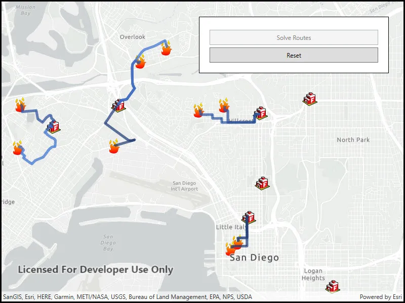
Quickly and accurately determining the most efficient route between a location and a facility is a frequently encountered task. For example, a city’s fire department may need to know which fire stations in the vicinity offer the quickest routes to multiple fires. Solving for the closest fire station to the fire’s location using an impedance of “travel time” would provide this information.
How to use the sample
Click the button to solve and display the route from each incident (fire) to the nearest facility (fire station).
How it works
- Create a
ClosestFacilityTaskusing a URL from an online service. - Get the default set of
ClosestFacilityParametersfrom the task:closestFacilityTask.CreateDefaultParametersAsync(). - Build a list of all
FacilitiesandIncidents:- Create a
FeatureTableusingServiceFeatureTable(Uri). - Query the
FeatureTablefor allFeaturesusingQueryFeaturesAsync(queryParameters). - Iterate over the result and add each
Featureto theList, instantiating the feature as aFacilityorIncident.
- Create a
- Add a list of all facilities to the task parameters.
- Add a list of all incidents to the task parameters.
- Get
ClosestFacilityResultby solving the task with the provided parameters. - Find the closest facility for each incident by iterating over the list of
Incidents. - Display the route as a
Graphicusing theclosestFacilityRoute.RouteGeometry.
Relevant API
- ClosestFacilityParameters
- ClosestFacilityResult
- ClosestFacilityRoute
- ClosestFacilityTask
- Facility
- Graphic
- GraphicsOverlay
- Incident
Tags
incident, network analysis, route, search
Sample code
// Copyright 2018 Esri.//// Licensed under the Apache License, Version 2.0 (the "License"); you may not use this file except in compliance with the License.// You may obtain a copy of the License at: http://www.apache.org/licenses/LICENSE-2.0//// Unless required by applicable law or agreed to in writing, software distributed under the License is distributed on an// "AS IS" BASIS, WITHOUT WARRANTIES OR CONDITIONS OF ANY KIND, either express or implied. See the License for the specific// language governing permissions and limitations under the License.
using Esri.ArcGISRuntime.Data;using Esri.ArcGISRuntime.Geometry;using Esri.ArcGISRuntime.Mapping;using Esri.ArcGISRuntime.Symbology;using Esri.ArcGISRuntime.Tasks.NetworkAnalysis;using Esri.ArcGISRuntime.UI;using System;using System.Collections.Generic;using System.Drawing;using System.Linq;using System.Threading.Tasks;
namespace ArcGIS.WPF.Samples.ClosestFacilityStatic{    [ArcGIS.Samples.Shared.Attributes.Sample(        name: "Find closest facility to multiple incidents (service)",        category: "Network analysis",        description: "Find routes from several locations to the respective closest facility.",        instructions: "Click the button to solve and display the route from each incident (fire) to the nearest facility (fire station).",        tags: new[] { "incident", "network analysis", "route", "search" })]    public partial class ClosestFacilityStatic    {        // Used to display route between incident and facility to mapview.        private List<SimpleLineSymbol> _routeSymbols;
        // Solves task to find closest route between an incident and a facility.        private ClosestFacilityTask _task;
        // Table of all facilities.        private ServiceFeatureTable _facilityTable;
        // Table of all incidents.        private ServiceFeatureTable _incidentTable;
        // Feature layer for facilities.        private FeatureLayer _facilityLayer;
        // Feature layer for incidents.        private FeatureLayer _incidentLayer;
        // Uri for facilities feature service.        private Uri _facilityUri = new Uri("https://services2.arcgis.com/ZQgQTuoyBrtmoGdP/ArcGIS/rest/services/San_Diego_Facilities/FeatureServer/0");
        // Uri for incident feature service.        private Uri _incidentUri = new Uri("https://services2.arcgis.com/ZQgQTuoyBrtmoGdP/ArcGIS/rest/services/San_Diego_Incidents/FeatureServer/0");
        // Uri for the closest facility service.        private Uri _closestFacilityUri = new Uri("https://sampleserver6.arcgisonline.com/arcgis/rest/services/NetworkAnalysis/SanDiego/NAServer/ClosestFacility");
        public ClosestFacilityStatic()        {            InitializeComponent();
            // Create the map and graphics overlays.            _ = Initialize();        }
        private async Task Initialize()        {            try            {                // Construct the map and set the MapView.Map property.                MyMapView.Map = new Map(BasemapStyle.ArcGISLightGray);
                // Add a graphics overlay to MyMapView. (Will be used later to display routes)                MyMapView.GraphicsOverlays.Add(new GraphicsOverlay());
                // Create a ClosestFacilityTask using the San Diego Uri.                _task = await ClosestFacilityTask.CreateAsync(_closestFacilityUri);
                // Create a symbol for displaying facilities.                PictureMarkerSymbol facilitySymbol = new PictureMarkerSymbol(new Uri("https://static.arcgis.com/images/Symbols/SafetyHealth/FireStation.png"))                {                    Height = 30,                    Width = 30                };
                // Incident symbol.                PictureMarkerSymbol incidentSymbol = new PictureMarkerSymbol(new Uri("https://static.arcgis.com/images/Symbols/SafetyHealth/esriCrimeMarker_56_Gradient.png"))                {                    Height = 30,                    Width = 30                };
                // Create a list of line symbols to show unique routes. Different colors help make different routes visually distinguishable.                _routeSymbols = new List<SimpleLineSymbol>()                {                    new SimpleLineSymbol(SimpleLineSymbolStyle.Solid, Color.FromArgb(125, 25, 45, 85), 5.0f),                    new SimpleLineSymbol(SimpleLineSymbolStyle.Solid, Color.FromArgb(125, 35, 65, 120), 5.0f),                    new SimpleLineSymbol(SimpleLineSymbolStyle.Solid, Color.FromArgb(125, 55, 100, 190), 5.0f),                    new SimpleLineSymbol(SimpleLineSymbolStyle.Solid, Color.FromArgb(125, 75, 140, 255), 5.0f)                };
                // Create a table for facilities using the FeatureServer.                _facilityTable = new ServiceFeatureTable(_facilityUri);
                // Create a feature layer from the table.                _facilityLayer = new FeatureLayer(_facilityTable)                {                    Renderer = new SimpleRenderer(facilitySymbol)                };
                // Create a table for facilities using the FeatureServer.                _incidentTable = new ServiceFeatureTable(_incidentUri);
                // Create a feature layer from the table.                _incidentLayer = new FeatureLayer(_incidentTable)                {                    Renderer = new SimpleRenderer(incidentSymbol)                };
                // Add the layers to the map.                MyMapView.Map.OperationalLayers.Add(_facilityLayer);                MyMapView.Map.OperationalLayers.Add(_incidentLayer);
                // Wait for both layers to load.                await _facilityLayer.LoadAsync();                await _incidentLayer.LoadAsync();
                // Zoom to the combined extent of both layers.                Envelope fullExtent = _facilityLayer.FullExtent.CombineExtents(_incidentLayer.FullExtent);                await MyMapView.SetViewpointGeometryAsync(fullExtent, 50);
                // Enable the solve button.                SolveRoutesButton.IsEnabled = true;            }            catch (Exception exception)            {                System.Windows.MessageBox.Show("An exception has occurred.\n" + exception.Message, "Sample error");            }        }
        private async void SolveRoutesClick(object sender, EventArgs e)        {            // Holds locations of hospitals around San Diego.            List<Facility> facilities = new List<Facility>();
            // Holds locations of hospitals around San Diego.            List<Incident> incidents = new List<Incident>();
            // Create query parameters to select all features.            QueryParameters queryParams = new QueryParameters()            {                WhereClause = "1=1"            };
            try            {                // Query all features in the facility table.                FeatureQueryResult facilityResult = await _facilityTable.QueryFeaturesAsync(queryParams);
                // Add all of the query results to facilities as new Facility objects.                facilities.AddRange(facilityResult.ToList().Select(feature => new Facility((MapPoint)feature.Geometry)));
                // Query all features in the incident table.                FeatureQueryResult incidentResult = await _incidentTable.QueryFeaturesAsync(queryParams);
                // Add all of the query results to facilities as new Incident objects.                incidents.AddRange(incidentResult.ToList().Select(feature => new Incident((MapPoint)feature.Geometry)));
                // Set facilities and incident in parameters.                ClosestFacilityParameters closestFacilityParameters = await _task.CreateDefaultParametersAsync();                closestFacilityParameters.SetFacilities(facilities);                closestFacilityParameters.SetIncidents(incidents);
                // Use the task to solve for the closest facility.                ClosestFacilityResult result = await _task.SolveClosestFacilityAsync(closestFacilityParameters);
                for (int i = 0; i < incidents.Count; i++)                {                    // Get the index of the closest facility to incident. (i) is the index of the incident, [0] is the index of the closest facility.                    int closestFacility = result.GetRankedFacilityIndexes(i)[0];
                    // Get the route to the closest facility.                    ClosestFacilityRoute route = result.GetRoute(closestFacility, i);
                    // Display the route on the graphics overlay.                    MyMapView.GraphicsOverlays[0].Graphics.Add(new Graphic(route.RouteGeometry, _routeSymbols[i % _routeSymbols.Count]));                }
                // Disable the solve button.                SolveRoutesButton.IsEnabled = false;
                // Enable the reset button.                ResetButton.IsEnabled = true;            }            catch (Exception ex)            {                System.Windows.MessageBox.Show(ex.Message, "Error");            }        }
        private void ResetClick(object sender, EventArgs e)        {            // Clear the route graphics.            MyMapView.GraphicsOverlays[0].Graphics.Clear();
// Reset the buttons. SolveRoutesButton.IsEnabled = true; ResetButton.IsEnabled = false; } }}<UserControl x:Class="ArcGIS.WPF.Samples.ClosestFacilityStatic.ClosestFacilityStatic" xmlns="http://schemas.microsoft.com/winfx/2006/xaml/presentation" xmlns:x="http://schemas.microsoft.com/winfx/2006/xaml" xmlns:esri="http://schemas.esri.com/arcgis/runtime/2013"> <Grid> <Grid> <esri:MapView x:Name="MyMapView" /> <Border Style="{StaticResource BorderStyle}"> <StackPanel> <Button x:Name="SolveRoutesButton" Height="30" Margin="0,5" HorizontalAlignment="Stretch" Click="SolveRoutesClick" Content="Solve Routes" IsEnabled="False" /> <Button x:Name="ResetButton" Height="30" HorizontalAlignment="Stretch" Click="ResetClick" Content="Reset" IsEnabled="False" /> </StackPanel> </Border> </Grid> </Grid></UserControl>