Solve a route on-the-fly using offline data.
Use case
You can use an offline network to enable routing in disconnected scenarios. For example, you could provide offline location capabilities to field workers repairing critical infrastructure in a disaster when network availability is limited.
How to use the sample
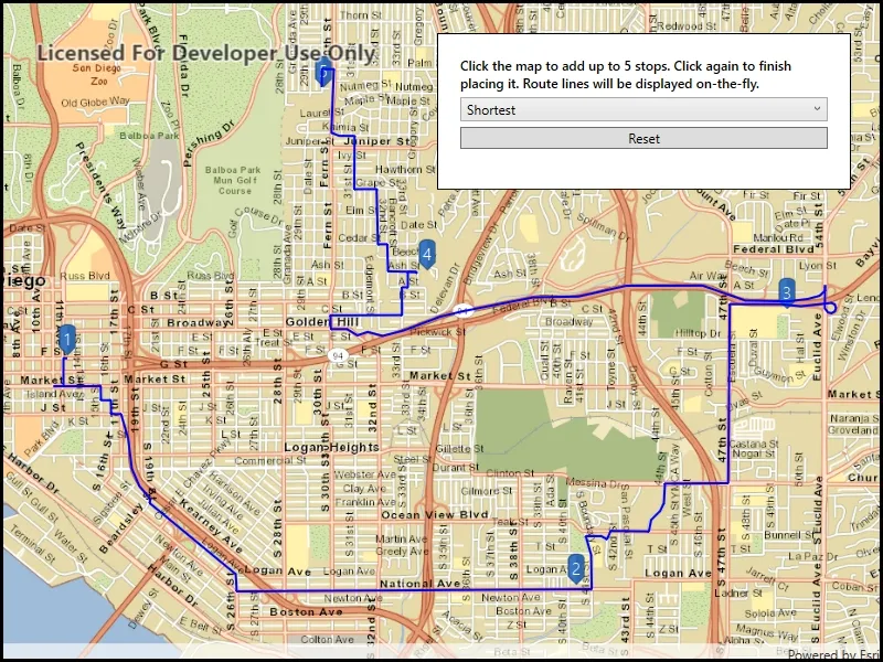
Click near a road to start adding a stop to the route, click again to place it on the map. A number graphic will show its order in the route. After adding at least 2 stops, a route will display. Choose “Fastest” or “Shortest” to control how the route is optimized. The route will update on-the-fly while moving stops. The green box marks the boundary of the routable area provided by the offline data. This sample limits routes to 5 stops for performance reasons.
How it works
- Create the map’s
Basemapfrom a local tile package using aTileCacheandArcGISTiledLayer - Create a
RouteTaskwith an offline locator geodatabase. - Get the
RouteParametersusingrouteTask.CreateDefaultParameters() - Create
Stops and add them to the route task’s parameters. - Solve the
RouteusingrouteTask.SolveRouteAsync(routeParameters) - Create a graphic with the route’s geometry and a
SimpleLineSymboland display it on anotherGraphicsOverlay.
Relevant API
- RouteParameters
- RouteResult
- RouteTask
- Stop
- TravelMode
Offline data
The data used by this sample is available on ArcGIS Online.
About the data
This sample uses a pre-packaged sample dataset consisting of a geodatabase with a San Diego road network and a tile package with a streets basemap.
Tags
connectivity, disconnected, fastest, locator, navigation, network analysis, offline, routing, shortest, turn-by-turn
Sample code
// Copyright 2019 Esri.//// Licensed under the Apache License, Version 2.0 (the "License"); you may not use this file except in compliance with the License.// You may obtain a copy of the License at: http://www.apache.org/licenses/LICENSE-2.0//// Unless required by applicable law or agreed to in writing, software distributed under the License is distributed on an// "AS IS" BASIS, WITHOUT WARRANTIES OR CONDITIONS OF ANY KIND, either express or implied. See the License for the specific// language governing permissions and limitations under the License.
using ArcGIS.Samples.Managers;using Esri.ArcGISRuntime.Geometry;using Esri.ArcGISRuntime.Mapping;using Esri.ArcGISRuntime.Symbology;using Esri.ArcGISRuntime.Tasks.NetworkAnalysis;using Esri.ArcGISRuntime.UI;using Esri.ArcGISRuntime.UI.Controls;using System;using System.Collections.Generic;using System.Diagnostics;using System.Drawing;using System.IO;using System.Linq;using System.Reflection;using System.Threading.Tasks;using System.Windows;using System.Windows.Controls;using System.Windows.Input;using Point = System.Windows.Point;
namespace ArcGIS.WPF.Samples.OfflineRouting{    [ArcGIS.Samples.Shared.Attributes.Sample(        name: "Offline routing",        category: "Network analysis",        description: "Solve a route on-the-fly using offline data.",        instructions: "Click near a road to start adding a stop to the route, click again to place it on the map. A number graphic will show its order in the route. After adding at least 2 stops, a route will display. Choose \"Fastest\" or \"Shortest\" to control how the route is optimized. The route will update on-the-fly while moving stops. The green box marks the boundary of the routable area provided by the offline data. This sample limits routes to 5 stops for performance reasons.",        tags: new[] { "connectivity", "disconnected", "fastest", "locator", "navigation", "network analysis", "offline", "routing", "shortest", "turn-by-turn" })]    [ArcGIS.Samples.Shared.Attributes.OfflineData("df193653ed39449195af0c9725701dca")]    public partial class OfflineRouting    {        // Graphics overlays for holding graphics.        private GraphicsOverlay _stopsOverlay;        private GraphicsOverlay _routeOverlay;
        // Route task and parameters.        private RouteTask _offlineRouteTask;        private RouteParameters _offlineRouteParameters;        private bool _parametersChangedSinceLastSolve = false;        private Task<RouteResult> _lastSolveTask = null;
        // List of travel modes, like 'Fastest' and 'Shortest'.        private List<TravelMode> _availableTravelModes;
        // Track the graphic being interacted with.        private Graphic _selectedStopGraphic;
        // The area covered by the geodatabase used for offline routing.        private readonly Envelope _routableArea = new Envelope(new MapPoint(-13045352.223196, 3864910.900750, 0, SpatialReferences.WebMercator),            new MapPoint(-13024588.857198, 3838880.505604, 0, SpatialReferences.WebMercator));
        public OfflineRouting()        {            InitializeComponent();            _ = Initialize();        }
        private async Task Initialize()        {            try            {                // Get the paths to resources used by the sample.                string basemapTilePath = DataManager.GetDataFolder("df193653ed39449195af0c9725701dca", "streetmap_SD.tpkx");                string networkGeodatabasePath = DataManager.GetDataFolder("df193653ed39449195af0c9725701dca", "sandiego.geodatabase");
                // Create the tile cache representing the offline basemap.                TileCache tiledBasemapCache = new TileCache(basemapTilePath);
                // Create a tiled layer to display the offline tiles.                ArcGISTiledLayer offlineTiledLayer = new ArcGISTiledLayer(tiledBasemapCache);
                // Create a basemap based on the tile layer.                Basemap offlineBasemap = new Basemap(offlineTiledLayer);
                // Create a new map with the offline basemap.                Map theMap = new Map(offlineBasemap);
                // Set the initial viewpoint to show the routable area.                theMap.InitialViewpoint = new Viewpoint(_routableArea);
                // Show the map in the map view.                MyMapView.Map = theMap;
                // Create overlays for displaying the stops and the calculated route.                _stopsOverlay = new GraphicsOverlay();                _routeOverlay = new GraphicsOverlay();
                // Create a symbol and renderer for symbolizing the calculated route.                SimpleLineSymbol routeSymbol = new SimpleLineSymbol(SimpleLineSymbolStyle.Solid, Color.Blue, 2);                _routeOverlay.Renderer = new SimpleRenderer(routeSymbol);
                // Add the stops and route overlays to the map.                MyMapView.GraphicsOverlays.Add(_stopsOverlay);                MyMapView.GraphicsOverlays.Add(_routeOverlay);
                // Create the route task, referring to the offline geodatabase with the street network.                _offlineRouteTask = await RouteTask.CreateAsync(networkGeodatabasePath, "Streets_ND");
                // Get the list of available travel modes.                _availableTravelModes = _offlineRouteTask.RouteTaskInfo.TravelModes.ToList();
                // Update the UI with the travel modes list.                TravelModesCombo.ItemsSource = _availableTravelModes;                TravelModesCombo.SelectedIndex = 0;
                // Create the default parameters.                _offlineRouteParameters = await _offlineRouteTask.CreateDefaultParametersAsync();
                // Display the extent of the road network on the map.                DisplayBoundaryMarker();
                // Now that the sample is ready, hook up the tapped and hover events.                MyMapView.GeoViewTapped += MapView_Tapped;                MyMapView.MouseMove += MapView_MouseMoved;                TravelModesCombo.SelectionChanged += TravelMode_SelectionChanged;            }            catch (Exception e)            {                Debug.WriteLine(e);                ShowMessage("Couldn't start sample", "There was a problem starting the sample. See debug output for details.");            }        }
        private void DisplayBoundaryMarker()        {            // Displaying the boundary marker helps avoid choosing a non-routable destination.            SimpleLineSymbol boundarySymbol = new SimpleLineSymbol(SimpleLineSymbolStyle.Dash, Color.LawnGreen, 5);            Graphic boundary = new Graphic(_routableArea, boundarySymbol);            GraphicsOverlay boundaryOverlay = new GraphicsOverlay();            boundaryOverlay.Graphics.Add(boundary);            MyMapView.GraphicsOverlays.Add(boundaryOverlay);        }
        private void ResetRoute()        {            _routeOverlay.Graphics.Clear();            _stopsOverlay.Graphics.Clear();
            // Reset the error message.            ErrorTextBlock.Text = "";        }
        private async Task UpdateRoute(TravelMode selectedTravelMode)        {            // Create a list of stops.            List<Stop> stops = new List<Stop>();
            // Add a stop to the list for each graphic in the stops overlay.            foreach (Graphic stopGraphic in _stopsOverlay.Graphics)            {                Stop stop = new Stop((MapPoint)stopGraphic.Geometry);                stops.Add(stop);            }
            if (stops.Count < 2)            {                // Don't route, there's no where to go (and the route task would throw an exception).                return;            }
            // Configure the route parameters with the list of stops.            _offlineRouteParameters.SetStops(stops);
            // Configure the travel mode.            _offlineRouteParameters.TravelMode = selectedTravelMode;
            // Check if a route calculation is already in progress            if (_lastSolveTask == null || _lastSolveTask.IsCompleted)            {                // No calculation in progress, start a new one                await SolveRouteAndDisplayResultsAsync();            }            else            {                // Route calculation already in progress, flag for recalculation when current task completes                _parametersChangedSinceLastSolve = true;            }        }
        private async Task SolveRouteAndDisplayResultsAsync()        {            do            {                try                {                    // Start the route calculation                    _lastSolveTask = _offlineRouteTask.SolveRouteAsync(_offlineRouteParameters);
                    // Reset the flag immediately after starting the task.                    // This ensures that any parameter changes made after this point will be caught for the next iteration.                    _parametersChangedSinceLastSolve = false;
                    // By awaiting here, we allow the UI to remain responsive while route calculation is in progress.                    // Any changes to parameters during this await will have set _parametersChangedSinceTaskRun to true.                    RouteResult offlineRouteResult = await _lastSolveTask;
                    // Clear the old route result.                    _routeOverlay.Graphics.Clear();
                    // Get the geometry from the route result.                    Polyline routeGeometry = offlineRouteResult.Routes.First().RouteGeometry;
                    // Note: symbology left out here because the symbology was set once on the graphics overlay.                    Graphic routeGraphic = new Graphic(routeGeometry);
                    // Display the route.                    _routeOverlay.Graphics.Add(routeGraphic);                }                catch (Exception e)                {                    Debug.WriteLine(e);                }            } while (_parametersChangedSinceLastSolve); // Recalculate if parameters changed during execution        }
        private async Task AddStop(Point tappedPosition)        {            try            {                // Get the location on the map.                MapPoint tappedLocation = MyMapView.ScreenToLocation(tappedPosition);
                // Name the stop by its number.                string stopName = $"{_stopsOverlay.Graphics.Count + 1}";
                // Create a pushpin marker for the stop.                PictureMarkerSymbol pushpinMarker = await GetPictureMarker();
                // Create the text symbol for labeling the stop.                TextSymbol stopSymbol = new TextSymbol(stopName, Color.White, 15,                    Esri.ArcGISRuntime.Symbology.HorizontalAlignment.Center, Esri.ArcGISRuntime.Symbology.VerticalAlignment.Middle);                stopSymbol.OffsetY = 15;
                // Create a combined symbol with the pushpin and the label.                CompositeSymbol combinedSymbol = new CompositeSymbol(new MarkerSymbol[] { pushpinMarker, stopSymbol });
                // Create the graphic from the geometry and the symbology.                Graphic newStopGraphic = new Graphic(tappedLocation, combinedSymbol);
                // Update the selection.                _selectedStopGraphic = newStopGraphic;
                // Add the stop to the overlay.                _stopsOverlay.Graphics.Add(newStopGraphic);            }            catch (Exception e)            {                Debug.WriteLine(e);                ShowMessage("Couldn't add stop", "Couldn't select or add stop. See debug output for details.");            }        }
        private async Task<PictureMarkerSymbol> GetPictureMarker()        {            // Hold a reference to the picture marker symbol.            PictureMarkerSymbol pinSymbol;
            // Get current assembly that contains the image.            Assembly currentAssembly = Assembly.GetExecutingAssembly();
            // Get the resource name of the blue pin image.            string resourceStreamName = this.GetType().Assembly.GetManifestResourceNames().Single(str => str.EndsWith("pin_blue.png"));
            // Load the blue pin resource stream.            using (Stream resourceStream = this.GetType().Assembly.                       GetManifestResourceStream(resourceStreamName))            {                // Create new symbol using asynchronous factory method from stream.                pinSymbol = await PictureMarkerSymbol.CreateAsync(resourceStream);                pinSymbol.Width = 50;                pinSymbol.Height = 50;                pinSymbol.LeaderOffsetX = 30;                pinSymbol.OffsetY = 14;            }
            return pinSymbol;        }
        private void ResetButton_Click(object sender, RoutedEventArgs e) => ResetRoute();
        private void MapView_Tapped(object sender, GeoViewInputEventArgs e)        {            // Reset the error message.            ErrorTextBlock.Text = "";
            // Make sure the stop is valid before proceeding.            if (!_routableArea.Contains(e.Location))            {                ShowMessage("Can't add stop.", "That location is outside of the area where offline routing data is available.");                return;            }
            if (_selectedStopGraphic == null && _stopsOverlay.Graphics.Count < 5)            {                // Select or add a stop.                _ = AddStop(e.Position);            }            else if (_selectedStopGraphic == null)            {                ShowMessage("Can't add stop.", "Sample limits to 5 stops per route.");            }            else            {                // Finish updating the geometry.                _selectedStopGraphic.Geometry = e.Location;
                // Reset the selected graphic.                _selectedStopGraphic = null;
                // Update the route with the final list of stops.                _ = UpdateRoute((TravelMode)TravelModesCombo.SelectedItem);            }        }
        private void MapView_MouseMoved(object sender, MouseEventArgs e)        {            if (_selectedStopGraphic != null)            {                // Get the position of the mouse relative to the map view.                Point hoverPoint = e.GetPosition(MyMapView);
                // Get the physical map location corresponding to the mouse position.                MapPoint hoverLocation = MyMapView.ScreenToLocation(hoverPoint);
                // Return if the location is outside the routable area.                if (!_routableArea.Contains(hoverLocation))                {                    return;                }
                // Update the location of the stop graphic.                _selectedStopGraphic.Geometry = hoverLocation;
                // Update the route with the temporary stop.                _ = UpdateRoute((TravelMode)TravelModesCombo.SelectedItem ?? _availableTravelModes.First());            }        }
        private void TravelMode_SelectionChanged(object sender, SelectionChangedEventArgs e)        {            try            {                if (TravelModesCombo.SelectedItem == null)                {                    TravelModesCombo.SelectedItem = _availableTravelModes.First();                }
                _ = UpdateRoute((TravelMode)TravelModesCombo.SelectedItem);            }            catch (Exception ex)            {                Debug.WriteLine(ex);                ShowMessage("Couldn't change travel mode", "Couldn't change travel mode. See debug output for details.");            }        }
private void ShowMessage(string title, string detail) { ErrorTextBlock.Text = detail; Debug.WriteLine(title); } }}<UserControl x:Class="ArcGIS.WPF.Samples.OfflineRouting.OfflineRouting" xmlns="http://schemas.microsoft.com/winfx/2006/xaml/presentation" xmlns:x="http://schemas.microsoft.com/winfx/2006/xaml" xmlns:esri="http://schemas.esri.com/arcgis/runtime/2013"> <Grid> <esri:MapView x:Name="MyMapView" /> <Border Style="{StaticResource BorderStyle}"> <Grid> <Grid.RowDefinitions> <RowDefinition Height="Auto" /> <RowDefinition Height="Auto" /> <RowDefinition Height="Auto" /> <RowDefinition Height="Auto" /> </Grid.RowDefinitions> <TextBlock Grid.Row="0" Grid.Column="0" FontWeight="SemiBold" Text="Click the map to add up to 5 stops. Click again to finish placing it. Route lines will be displayed on-the-fly." TextWrapping="Wrap" /> <ComboBox x:Name="TravelModesCombo" Grid.Row="1" Margin="0,5,0,5"> <ComboBox.ItemTemplate> <DataTemplate> <TextBlock Text="{Binding Name}" /> </DataTemplate> </ComboBox.ItemTemplate> </ComboBox> <Button Grid.Row="2" Click="ResetButton_Click" Content="Reset" /> <TextBlock x:Name="ErrorTextBlock" Grid.Row="3" Foreground="Red" TextWrapping="Wrap" /> </Grid> </Border> </Grid></UserControl>