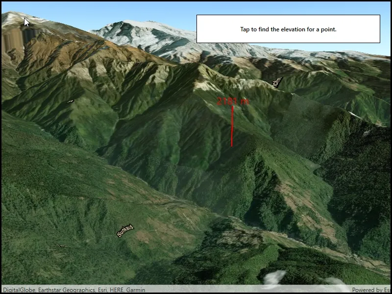
Get the elevation for a given point on a surface in a scene.
Use case
Knowing the elevation at a given point in a landscape can aid in navigation, planning and survey in the field.
How to use the sample
Tap anywhere on the surface to get the elevation at that point. Elevation is reported in meters since the scene view is in WGS84.
How it works
- Create a
SceneViewandScenewith an imagery base map. - Set an
ArcGISTiledElevationSourceas the elevation source of the scene’s base surface. - Use the
GetElevationAsync(surfacePoint)method on the base surface to asynchronously get the elevation.
Relevant API
- ArcGISTiledElevationSource
- BaseSurface
- ElevationSourcesList
- SceneView
Additional information
GetElevationAsync(surfacePoint) retrieves the most accurate available elevation value at a given point. To do this, the method must go to the server or local raster file and load the highest level of detail of data for the target location and return the elevation value.
If multiple elevation sources are present in the surface, the top most visible elevation source with a valid elevation in the given location is used to determine the result.
Tags
elevation, point, surface
Sample code
// Copyright 2019 Esri.//// Licensed under the Apache License, Version 2.0 (the "License"); you may not use this file except in compliance with the License.// You may obtain a copy of the License at: http://www.apache.org/licenses/LICENSE-2.0//// Unless required by applicable law or agreed to in writing, software distributed under the License is distributed on an// "AS IS" BASIS, WITHOUT WARRANTIES OR CONDITIONS OF ANY KIND, either express or implied. See the License for the specific// language governing permissions and limitations under the License.
using Esri.ArcGISRuntime.Geometry;using Esri.ArcGISRuntime.Mapping;using Esri.ArcGISRuntime.Symbology;using Esri.ArcGISRuntime.UI;using System;using System.Diagnostics;using System.Drawing;using System.Windows;
namespace ArcGIS.WPF.Samples.GetElevationAtPoint{    [ArcGIS.Samples.Shared.Attributes.Sample(        name: "Get elevation at a point",        category: "Scene",        description: "Get the elevation for a given point on a surface in a scene.",        instructions: "Tap anywhere on the surface to get the elevation at that point. Elevation is reported in meters since the scene view is in WGS84.",        tags: new[] { "elevation", "point", "surface" })]    public partial class GetElevationAtPoint    {        // URL of the elevation service - provides elevation component of the scene.        private readonly Uri _elevationUri = new Uri("https://elevation3d.arcgis.com/arcgis/rest/services/WorldElevation3D/Terrain3D/ImageServer");
        // Starting point of the observer.        private readonly MapPoint _observerPoint = new MapPoint(83.9, 28.42, SpatialReferences.Wgs84);
        // Graphics overlay.        private GraphicsOverlay _overlay;
        // Surface (for elevation).        private Surface _baseSurface;
        // Create symbols for the text and marker.        private SimpleMarkerSceneSymbol _elevationMarker;        private TextSymbol _elevationTextSymbol;        private readonly Graphic _elevationTextGraphic = new Graphic();
        public GetElevationAtPoint()        {            InitializeComponent();
            // Create the UI, setup the control references and execute initialization.            Initialize();
            // Handle taps on the scene view for getting elevation.            MySceneView.GeoViewTapped += SceneViewTapped;        }
        private void Initialize()        {            // Create the camera for the scene.            Camera camera = new Camera(_observerPoint, 20000.0, 10.0, 70.0, 0.0);
            // Create a scene.            Scene myScene = new Scene(BasemapStyle.ArcGISImagery)            {                // Set the initial viewpoint.                InitialViewpoint = new Viewpoint(_observerPoint, 1000000, camera)            };
            // Create the marker for showing where the user taps.            _elevationMarker = SimpleMarkerSceneSymbol.CreateCylinder(Color.Red, 10, 750);
            // Create the text for displaying the elevation value.            _elevationTextSymbol = new TextSymbol("", Color.Red, 20, Esri.ArcGISRuntime.Symbology.HorizontalAlignment.Center, Esri.ArcGISRuntime.Symbology.VerticalAlignment.Middle);            _elevationTextGraphic.Symbol = _elevationTextSymbol;
            // Create the base surface.            _baseSurface = new Surface();            _baseSurface.ElevationSources.Add(new ArcGISTiledElevationSource(_elevationUri));
            // Add the base surface to the scene.            myScene.BaseSurface = _baseSurface;
            // Graphics overlay for displaying points.            _overlay = new GraphicsOverlay            {                SceneProperties = new LayerSceneProperties(SurfacePlacement.Absolute)            };            MySceneView.GraphicsOverlays.Add(_overlay);
            // Add the scene to the view.            MySceneView.Scene = myScene;        }
        private async void SceneViewTapped(object sender, Esri.ArcGISRuntime.UI.Controls.GeoViewInputEventArgs e)        {            try            {                // Remove this method from the event handler to prevent concurrent calls.                MySceneView.GeoViewTapped -= SceneViewTapped;
                // Check that the point is on the surface.                if (e.Location != null)                {                    // Clear any existing graphics from the graphics overlay.                    _overlay.Graphics.Clear();
                    // Get the elevation value.                    double elevation = await _baseSurface.GetElevationAsync(e.Location);
                    // Set the text displaying the elevation.                    _elevationTextSymbol.Text = $"{Math.Round(elevation)} m";                    _elevationTextGraphic.Geometry = new MapPoint(e.Location.X, e.Location.Y, e.Location.Z + 850);
                    // Add the text to the graphics overlay.                    _overlay.Graphics.Add(_elevationTextGraphic);
// Add the marker indicating where the user tapped. _overlay.Graphics.Add(new Graphic(e.Location, _elevationMarker)); } } catch (Exception ex) { Debug.WriteLine(ex.Message); MessageBox.Show(ex.Message, "Sample error"); } finally { // Re-add to the event handler. MySceneView.GeoViewTapped += SceneViewTapped; } } }}<UserControl x:Class="ArcGIS.WPF.Samples.GetElevationAtPoint.GetElevationAtPoint" xmlns="http://schemas.microsoft.com/winfx/2006/xaml/presentation" xmlns:x="http://schemas.microsoft.com/winfx/2006/xaml" xmlns:esri="http://schemas.esri.com/arcgis/runtime/2013"> <Grid> <esri:SceneView x:Name="MySceneView" /> <Border Style="{StaticResource BorderStyle}"> <TextBlock FontWeight="SemiBold" Text="Tap to find the elevation for a point." TextAlignment="Center" TextWrapping="Wrap" /> </Border> </Grid></UserControl>