Use a geoprocessing service and a set of features to identify statistically significant hot spots and cold spots.
Use case
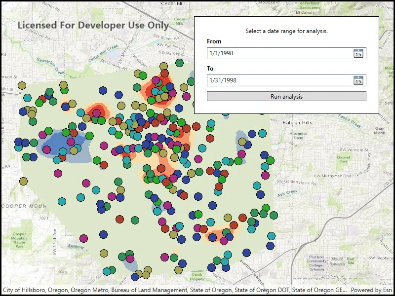
This tool identifies statistically significant spatial clusters of high values (hot spots) and low values (cold spots). For example, a hotspot analysis based on the frequency of 911 calls within a set region.
How to use the sample
Select a date range (between 1998-01-01 and 1998-05-31) from the dialog and tap on Analyze. The results will be shown on the map upon successful completion of the GeoprocessingJob.
How it works
- Create a
GeoprocessingTaskwith the URL set to the endpoint of a geoprocessing service. - Create a query string with the date range as an input of
GeoprocessingParameters. - Use the
GeoprocessingTaskto create aGeoprocessingJobwith theGeoprocessingParametersinstance. - Start the
GeoprocessingJoband wait for it to complete and return aGeoprocessingResult. - Get the resulting
ArcGISMapImageLayerusingGeoprocessingResult.MapImageLayer. - Add the layer to the map’s operational layers.
Relevant API
- GeoprocessingJob
- GeoprocessingParameters
- GeoprocessingResult
- GeoprocessingTask
Tags
analysis, density, geoprocessing, hot spots, hotspots
Sample code
// Copyright 2016 Esri.//// Licensed under the Apache License, Version 2.0 (the "License"); you may not use this file except in compliance with the License.// You may obtain a copy of the License at: http://www.apache.org/licenses/LICENSE-2.0//// Unless required by applicable law or agreed to in writing, software distributed under the License is distributed on an// "AS IS" BASIS, WITHOUT WARRANTIES OR CONDITIONS OF ANY KIND, either express or implied. See the License for the specific// language governing permissions and limitations under the License.
using Esri.ArcGISRuntime.Mapping;using Esri.ArcGISRuntime.Tasks;using Esri.ArcGISRuntime.Tasks.Geoprocessing;using System;using System.Threading.Tasks;using System.Windows;
namespace ArcGIS.WPF.Samples.AnalyzeHotspots{    [ArcGIS.Samples.Shared.Attributes.Sample(        name: "Analyze hotspots",        category: "Geoprocessing",        description: "Use a geoprocessing service and a set of features to identify statistically significant hot spots and cold spots.",        instructions: "Select a date range (between 1998-01-01 and 1998-05-31) from the dialog and tap on Analyze. The results will be shown on the map upon successful completion of the `GeoprocessingJob`.",        tags: new[] { "analysis", "density", "geoprocessing", "hot spots", "hotspots" })]    public partial class AnalyzeHotspots    {        // URL for the geoprocessing service        private const string _hotspotUrl =            "https://sampleserver6.arcgisonline.com/arcgis/rest/services/911CallsHotspot/GPServer/911%20Calls%20Hotspot";
        // The geoprocessing task for hot spot analysis        private GeoprocessingTask _hotspotTask;
        // The job that handles the communication between the application and the geoprocessing task        private GeoprocessingJob _hotspotJob;
        public AnalyzeHotspots()        {            InitializeComponent();
            // Create the UI, setup the control references and execute initialization            _ = Initialize();        }
        private async Task Initialize()        {            // Create a map with a topographic basemap            MyMapView.Map = new Map(BasemapStyle.ArcGISTopographic);
            try            {                // Create a new geoprocessing task                _hotspotTask = await GeoprocessingTask.CreateAsync(new Uri(_hotspotUrl));            }            catch (Exception e)            {                MessageBox.Show(e.ToString(), "Error");            }        }
        private async void OnAnalyzeHotspotsClicked(object sender, RoutedEventArgs e)        {            // Clear any existing results            MyMapView.Map.OperationalLayers.Clear();
            // Show the waiting indication            ShowBusyOverlay();
            // Get the 'from' and 'to' dates from the date pickers for the geoprocessing analysis            DateTime myFromDate = FromDate.SelectedDate.Value;            DateTime myToDate = ToDate.SelectedDate.Value;
            // The end date must be at least one day after the start date            if (myToDate <= myFromDate.AddDays(1))            {                // Show error message                MessageBox.Show(                    "Please select valid time range. There has to be at least one day in between To and From dates.",                    "Invalid date range");
                // Remove the waiting                ShowBusyOverlay(false);                return;            }
            // Create the parameters that are passed to the used geoprocessing task            GeoprocessingParameters myHotspotParameters = new GeoprocessingParameters(GeoprocessingExecutionType.AsynchronousSubmit);
            // Construct the date query            string myQueryString = string.Format("(\"DATE\" > date '{0:yyyy-MM-dd} 00:00:00' AND \"DATE\" < date '{1:yyyy-MM-dd} 00:00:00')", myFromDate, myToDate);
            // Add the query that contains the date range used in the analysis            myHotspotParameters.Inputs.Add("Query", new GeoprocessingString(myQueryString));
            // Create job that handles the communication between the application and the geoprocessing task            _hotspotJob = _hotspotTask.CreateJob(myHotspotParameters);            try            {                // Execute the geoprocessing analysis and wait for the results                GeoprocessingResult myAnalysisResult = await _hotspotJob.GetResultAsync();
                // Add results to a map using map server from a geoprocessing task                // Load to get access to full extent                await myAnalysisResult.MapImageLayer.LoadAsync();
                // Add the analysis layer to the map view                MyMapView.Map.OperationalLayers.Add(myAnalysisResult.MapImageLayer);
                // Zoom to the results                await MyMapView.SetViewpointAsync(new Viewpoint(myAnalysisResult.MapImageLayer.FullExtent));            }            catch (TaskCanceledException)            {                // This is thrown if the task is canceled. Ignore.            }            catch (Exception ex)            {                // Display error messages if the geoprocessing task fails                if (_hotspotJob.Status == JobStatus.Failed && _hotspotJob.Error != null)                    MessageBox.Show("Executing geoprocessing failed. " + _hotspotJob.Error.Message, "Geoprocessing error");                else                    MessageBox.Show("An error occurred. " + ex, "Sample error");            }            finally            {                // Remove the waiting                ShowBusyOverlay(false);            }        }
        private void OnCancelTaskClicked(object sender, RoutedEventArgs e)        {            // Cancel current geoprocessing job            if (_hotspotJob.Status == JobStatus.Started)                _hotspotJob.CancelAsync();
            // Hide the waiting indication            ShowBusyOverlay(false);        }
        private void ShowBusyOverlay(bool visibility = true)        {            // Function to toggle the visibility of interaction with the GUI for the user to            // specify dates for the hot spot analysis. When the analysis is running, the GUI            // for changing the dates is 'grayed-out' and the progress bar with a cancel            // button (aka. waiting object) becomes active.
if (visibility) { // The geoprocessing task is processing. The busyOverly is present. BusyOverlay.Visibility = Visibility.Visible; Progress.IsIndeterminate = true; } else { // The user can interact with the date pickers. The waiting is invisible. BusyOverlay.Visibility = Visibility.Collapsed; Progress.IsIndeterminate = false; } } }}<UserControl x:Class="ArcGIS.WPF.Samples.AnalyzeHotspots.AnalyzeHotspots" xmlns="http://schemas.microsoft.com/winfx/2006/xaml/presentation" xmlns:x="http://schemas.microsoft.com/winfx/2006/xaml" xmlns:esri="http://schemas.esri.com/arcgis/runtime/2013"> <Grid> <esri:MapView x:Name="MyMapView" /> <Border Style="{StaticResource BorderStyle}"> <Grid> <Grid.RowDefinitions> <RowDefinition /> <RowDefinition /> <RowDefinition /> <RowDefinition /> <RowDefinition /> <RowDefinition /> </Grid.RowDefinitions> <!-- Main form --> <TextBlock Grid.Row="0" Text="Select a date range for analysis." TextAlignment="Center" TextWrapping="Wrap" /> <TextBlock Grid.Row="1" Margin="5,5,5,0" FontWeight="Bold" Text="From" /> <DatePicker x:Name="FromDate" Grid.Row="2" Margin="5" HorizontalAlignment="Stretch" DisplayDateEnd="5/31/98" DisplayDateStart="1/01/98" SelectedDate="1/01/98" /> <TextBlock Grid.Row="3" Margin="5,5,5,0" FontWeight="Bold" Text="To" /> <DatePicker x:Name="ToDate" Grid.Row="4" Margin="5" HorizontalAlignment="Stretch" DisplayDateEnd="5/31/98" DisplayDateStart="1/01/98" SelectedDate="1/31/98" /> <Button x:Name="AnalyzeButton" Grid.Row="5" Margin="5" Click="OnAnalyzeHotspotsClicked" Content="Run analysis" /> <!-- Waiting overlay --> <Grid x:Name="BusyOverlay" Grid.Row="0" Grid.RowSpan="6" Margin="-20" Background="#8C000000" Visibility="Collapsed"> <Border Padding="15" HorizontalAlignment="Center" VerticalAlignment="Center" Background="#FFC6C4C4"> <Grid> <Grid.RowDefinitions> <RowDefinition Height="auto" /> <RowDefinition Height="auto" /> </Grid.RowDefinitions> <ProgressBar x:Name="Progress" Height="20" IsIndeterminate="True" /> <TextBlock Grid.Row="0" Height="20" Margin="5" HorizontalAlignment="Center" Text="Executing analysis..." /> <Button Grid.Row="1" HorizontalAlignment="Center" Click="OnCancelTaskClicked" Content="Cancel" /> </Grid> </Border> </Grid> </Grid> </Border> </Grid></UserControl>