Find the service area within a network from a given point.
Use case
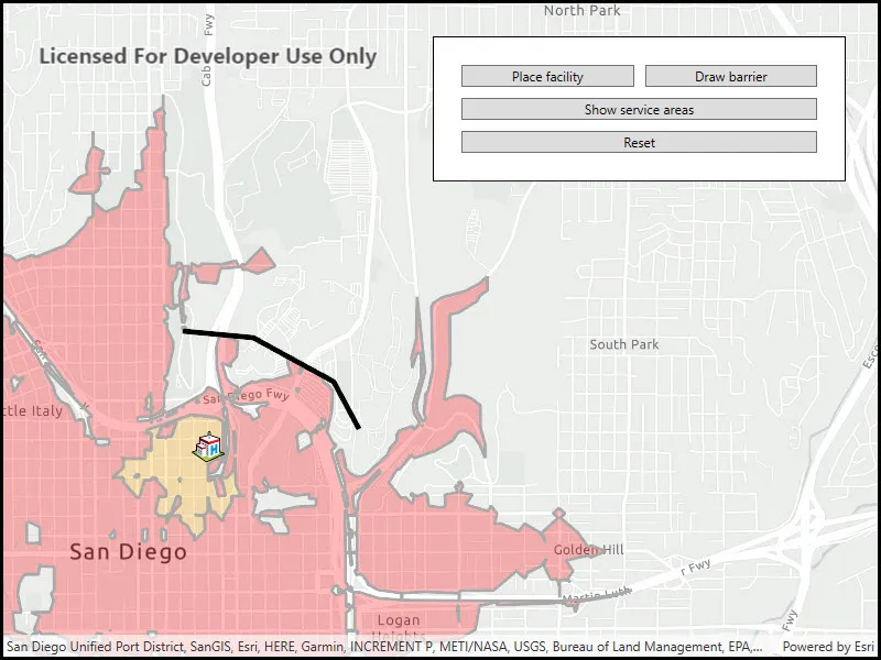
A service area shows locations that can be reached from a facility based off a certain impedance, such as travel time or distance. Barriers can increase impedance by either adding to the time it takes to pass through the barrier or by altogether preventing passage.
You might calculate the region around a hospital in which ambulances can service in 30 min or less.
How to use the sample
In order to find any service areas at least one facility needs to be added to the map view.
- To add a facility, click the facility button, then click anywhere on the map.
- To add a barrier, click the barrier button, and click multiple locations on map. Hit the barrier button again to finish drawing barrier. Hitting any other button will also stop the barrier from drawing.
- To show service areas around facilities that were added, click show service areas button.
- The reset button clears all graphics and resets the service area task.
How it works
- Create a new
ServiceAreaTaskfrom a network service. - Create default
ServiceAreaParametersfrom the service area task. - Set the parameters to return polygons (true) to return all service areas.
- Add a
ServiceAreaFacilityto the parameters. - Get the
ServiceAreaResultby solving the service area task using the parameters. - Get any
ServiceAreaPolygonsthat were returned. - Display the service area polygons as graphics in a
GraphicsOverlayon theMapView.
Relevant API
- PolylineBarrier
- ServiceAreaFacility
- ServiceAreaParameters
- ServiceAreaPolygon
- ServiceAreaResult
- ServiceAreaTask
Tags
barriers, facilities, geometry editor, impedance, logistics, routing
Sample code
// Copyright 2018 Esri.//// Licensed under the Apache License, Version 2.0 (the "License"); you may not use this file except in compliance with the License.// You may obtain a copy of the License at: http://www.apache.org/licenses/LICENSE-2.0//// Unless required by applicable law or agreed to in writing, software distributed under the License is distributed on an// "AS IS" BASIS, WITHOUT WARRANTIES OR CONDITIONS OF ANY KIND, either express or implied. See the License for the specific// language governing permissions and limitations under the License.
using Esri.ArcGISRuntime.Geometry;using Esri.ArcGISRuntime.Mapping;using Esri.ArcGISRuntime.Symbology;using Esri.ArcGISRuntime.Tasks.NetworkAnalysis;using Esri.ArcGISRuntime.UI;using Esri.ArcGISRuntime.UI.Editing;using System;using System.Collections.Generic;using System.Linq;using System.Windows;
namespace ArcGIS.WPF.Samples.FindServiceArea{    [ArcGIS.Samples.Shared.Attributes.Sample(        name: "Find service area",        category: "Network analysis",        description: "Find the service area within a network from a given point.",        instructions: "In order to find any service areas at least one facility needs to be added to the map view.",        tags: new[] { "barriers", "facilities", "geometry editor", "impedance", "logistics", "routing" })]    public partial class FindServiceArea    {        // Uri for the service area around San Diego.        private Uri _serviceAreaUri = new Uri("https://sampleserver7.arcgisonline.com/server/rest/services/NetworkAnalysis/SanDiego/NAServer/ServiceArea");
        // Hold a reference to the geometry type used in the geometry editor.        private GeometryType _geometryType;
        public FindServiceArea()        {            InitializeComponent();
            // Create the map, graphics overlay, and geometry editor.            Initialize();        }
        private void Initialize()        {            // Center the map on San Diego.            Map streetsMap = new Map(BasemapStyle.ArcGISLightGray)            {                InitialViewpoint = new Viewpoint(32.73, -117.14, 30000)            };            MyMapView.Map = streetsMap;
            // Create graphics overlays for all of the elements of the map.            MyMapView.GraphicsOverlays.Add(new GraphicsOverlay());
            MyMapView.GeoViewDoubleTapped += (s, e) =>            {                // Finish any barrier.                if (MyMapView.GeometryEditor.IsStarted && _geometryType == GeometryType.Polyline)                {                    FinishBarrier();                }            };        }
        private void PlaceFacilityButton_Click(object sender, RoutedEventArgs e)        {            try            {                // Let the user tap on the map view using the point geometry type.                _geometryType = GeometryType.Point;
                MyMapView.GeometryEditor.Start(_geometryType);                MyMapView.GeometryEditor.PropertyChanged += GeometryEditor_PropertyChanged;            }            catch (Exception ex)            {                // Report exceptions.                MessageBox.Show("Error drawing facility:\n" + ex.Message);            }        }
        private void GeometryEditor_PropertyChanged(object sender, System.ComponentModel.PropertyChangedEventArgs e)        {            if (e.PropertyName == nameof(GeometryEditor.Geometry) && _geometryType == GeometryType.Point)            {                // Disconnect event handler to prevent multiple calls.                MyMapView.GeometryEditor.PropertyChanged -= GeometryEditor_PropertyChanged;
                // Get the active geometry.                Geometry geometry = MyMapView.GeometryEditor.Geometry;
                // Symbology for a facility.                PictureMarkerSymbol facilitySymbol = new PictureMarkerSymbol(new Uri("https://static.arcgis.com/images/Symbols/SafetyHealth/Hospital.png"))                {                    Height = 30,                    Width = 30                };
                // Create a graphic for the facility.                Graphic facilityGraphic = new Graphic(geometry, new Dictionary<string, object>() { { "Type", "Facility" } }, facilitySymbol)                {                    ZIndex = 2                };
                // Add the graphic to the graphics overlay.                MyMapView.GraphicsOverlays[0].Graphics.Add(facilityGraphic);
                // Stop the geometry editor to clear the active geometry.                MyMapView.GeometryEditor.Stop();            }        }
        private void DrawBarrierButton_Click(object sender, RoutedEventArgs e)        {            // Finish the drawing if already started.            if ((string)DrawBarrierButton.Content != "Draw barrier")            {                if (MyMapView.GeometryEditor.IsStarted)                {                    FinishBarrier();                }                DrawBarrierButton.Content = "Draw barrier";                return;            }            try            {                // Update the button title.                DrawBarrierButton.Content = "Finish barrier";
                // Let the user draw on the map view using the polyline geometry type.                _geometryType = GeometryType.Polyline;
                MyMapView.GeometryEditor.Start(_geometryType);            }            catch (Exception ex)            {                // Report exceptions.                MessageBox.Show("Error drawing barrier:\n" + ex.Message);            }        }
        private void FinishBarrier()        {            Geometry geometry = MyMapView.GeometryEditor.Stop();
            if (!geometry.IsEmpty)            {                // Symbol for the barriers.                SimpleLineSymbol barrierSymbol = new SimpleLineSymbol(SimpleLineSymbolStyle.Solid, System.Drawing.Color.Black, 5.0f);
                // Create the graphic to be used for barriers.                Graphic barrierGraphic = new Graphic(geometry, new Dictionary<string, object>() { { "Type", "Barrier" } }, barrierSymbol)                {                    ZIndex = 1                };
                // Add a graphic from the polyline the user drew.                MyMapView.GraphicsOverlays[0].Graphics.Add(barrierGraphic);
                // Update button text.                DrawBarrierButton.Content = "Draw barrier";            }        }
        private async void ShowServiceAreasButton_Click(object sender, RoutedEventArgs e)        {            // Finish any drawings.            if (MyMapView.GeometryEditor.IsStarted)            {                FinishBarrier();            }
            // Use a local variable for the graphics overlay.            GraphicCollection allGraphics = MyMapView.GraphicsOverlays[0].Graphics;
            // Get a list of the facilities from the graphics overlay.            List<ServiceAreaFacility> serviceAreaFacilities = (from g in allGraphics                                                               where (string)g.Attributes["Type"] == "Facility"                                                               select new ServiceAreaFacility((MapPoint)g.Geometry)).ToList();
            // Check that there is at least 1 facility to find a service area for.            if (!serviceAreaFacilities.Any())            {                MessageBox.Show("Must have at least one Facility!", "Sample error");                return;            }
            // Create the service area task and parameters based on the Uri.            ServiceAreaTask serviceAreaTask = await ServiceAreaTask.CreateAsync(_serviceAreaUri);
            // Store the default parameters for the service area in an object.            ServiceAreaParameters serviceAreaParameters = await serviceAreaTask.CreateDefaultParametersAsync();
            // Add impedance cutoffs for facilities (drive time minutes).            serviceAreaParameters.DefaultImpedanceCutoffs.Clear();            serviceAreaParameters.DefaultImpedanceCutoffs.Add(2.0);            serviceAreaParameters.DefaultImpedanceCutoffs.Add(5.0);
            // Set the level of detail for the polygons.            serviceAreaParameters.PolygonDetail = ServiceAreaPolygonDetail.High;
            // Get a list of the barriers from the graphics overlay.            List<PolylineBarrier> polylineBarriers = (from g in allGraphics                                                      where (string)g.Attributes["Type"] == "Barrier"                                                      select new PolylineBarrier((Polyline)g.Geometry)).ToList();
            // Add the barriers to the service area parameters.            serviceAreaParameters.SetPolylineBarriers(polylineBarriers);
            // Update the parameters to include all of the placed facilities.            serviceAreaParameters.SetFacilities(serviceAreaFacilities);
            // Clear existing graphics for service areas.            foreach (Graphic g in allGraphics.ToList())            {                // Check if the graphic g is a service area.                if ((string)g.Attributes["Type"] == "ServiceArea")                {                    allGraphics.Remove(g);                }            }
            try            {                // Solve for the service area of the facilities.                ServiceAreaResult result = await serviceAreaTask.SolveServiceAreaAsync(serviceAreaParameters);
                // Loop over each facility.                for (int i = 0; i < serviceAreaFacilities.Count; i++)                {                    // Create list of polygons from a service facility.                    List<ServiceAreaPolygon> polygons = result.GetResultPolygons(i).ToList();
                    // Symbol for the outline of the service areas.                    SimpleLineSymbol serviceOutline = new SimpleLineSymbol(SimpleLineSymbolStyle.Solid, System.Drawing.Color.DarkGray, 3.0f);
                    // Create a list of fill symbols for the polygons.                    List<SimpleFillSymbol> fillSymbols = new List<SimpleFillSymbol>();                    fillSymbols.Add(new SimpleFillSymbol(SimpleFillSymbolStyle.Solid, System.Drawing.Color.FromArgb(70, 255, 0, 0), serviceOutline));                    fillSymbols.Add(new SimpleFillSymbol(SimpleFillSymbolStyle.Solid, System.Drawing.Color.FromArgb(70, 255, 165, 0), serviceOutline));
                    // Loop over every polygon in every facilities result.                    for (int j = 0; j < polygons.Count; j++)                    {                        // Create the graphic for the service areas, alternating between fill symbols.                        Graphic serviceGraphic = new Graphic(polygons[j].Geometry, new Dictionary<string, object>() { { "Type", "ServiceArea" } }, fillSymbols[j % 2])                        {                            ZIndex = 0                        };
                        // Add graphic for service area. Alternate the color of each polygon.                        allGraphics.Add(serviceGraphic);                    }                }            }            catch (Exception exception)            {                MessageBox.Show("An exception has occurred. The facility may not be within the San Diego area. \n" + exception.Message.ToString(), "Sample error");            }        }
private void Reset_Click(object sender, RoutedEventArgs e) { // Clear all of the graphics. MyMapView.GraphicsOverlays[0].Graphics.Clear(); } }}<UserControl x:Class="ArcGIS.WPF.Samples.FindServiceArea.FindServiceArea" xmlns="http://schemas.microsoft.com/winfx/2006/xaml/presentation" xmlns:x="http://schemas.microsoft.com/winfx/2006/xaml" xmlns:esri="http://schemas.esri.com/arcgis/runtime/2013"> <Grid> <esri:MapView x:Name="MyMapView" /> <Border Style="{StaticResource BorderStyle}"> <Grid> <Grid.ColumnDefinitions> <ColumnDefinition Width="*" /> <ColumnDefinition Width="*" /> </Grid.ColumnDefinitions> <Grid.RowDefinitions> <RowDefinition /> <RowDefinition /> <RowDefinition /> <RowDefinition /> <RowDefinition /> </Grid.RowDefinitions> <Button Name="PlaceFacilityButton" Grid.Row="0" Grid.Column="0" Margin="5,5,5,5" Click="PlaceFacilityButton_Click" Content="Place facility" /> <Button Name="DrawBarrierButton" Grid.Row="0" Grid.Column="1" Margin="5,5,5,5" Click="DrawBarrierButton_Click" Content="Draw barrier" /> <Button Name="ShowServiceAreasButton" Grid.Row="3" Grid.ColumnSpan="2" Margin="5,5,5,5" Click="ShowServiceAreasButton_Click" Content="Show service areas" /> <Button Name="ResetButton" Grid.Row="4" Grid.ColumnSpan="2" Margin="5,5,5,5" Click="Reset_Click" Content="Reset" /> </Grid> </Border> </Grid></UserControl>