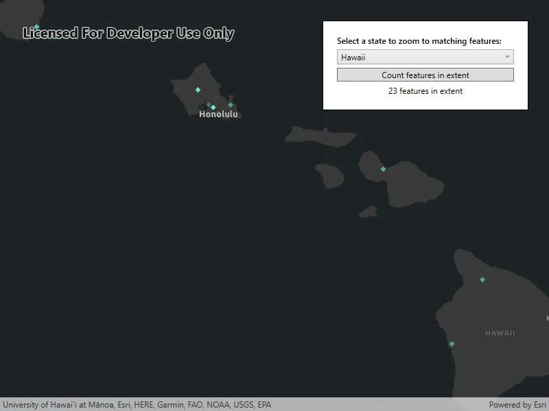
Zoom to features matching a query and count the features in the current visible extent.
Use case
Queries can be used to search for features in a feature table using text entry. This is helpful for finding a specific feature by name in a large feature table. A query can also be used to count features in an extent. This could be used to count the number of a traffic incidents in a particular region when working with an incident dataset for a larger area.
How to use the sample
Use the picker to zoom to the extent of the state specified. Use the button to count the features in the current extent.
How it works
Querying by state abbreviation:
- A
QueryParametersobject is created with aWhereClause. FeatureTable.QueryExtentAsyncis called with theQueryParametersobject to obtain the extent that contains all matching features.- The extent is converted to a
Viewpoint, which is passed toMapView.SetViewpointAsync.
Counting features in the current extent:
- The current visible extent is obtained from a call to
MapView.GetCurrentViewpoint(ViewpointType). - A
QueryParametersobject is created with the visible extent and a definedSpatialRelationship(in this case ‘intersects’). - The count of matching features is obtained from a call to
FeatureTable.QueryFeatureCountAsync.
Relevant API
- FeatureTable.QueryExtentAsync
- FeatureTable.QueryFeatureCountAsync
- MapView.GetCurrentViewpoint(ViewpointType)
- QueryParameters
- QueryParameters.Geometry
- QueryParameters.SpatialRelationship
- QueryParameters.WhereClause
About the data
See the Medicare Hospital Spending per Patient, 2016 layer on ArcGIS Online.
Hospitals in blue/turquoise spend less than the national average. Red/salmon indicates higher spending relative to other hospitals, while gray is average.
Tags
count, feature layer, feature table, features, filter, number, query
Sample code
// Copyright 2018 Esri.//// Licensed under the Apache License, Version 2.0 (the "License"); you may not use this file except in compliance with the License.// You may obtain a copy of the License at: http://www.apache.org/licenses/LICENSE-2.0//// Unless required by applicable law or agreed to in writing, software distributed under the License is distributed on an// "AS IS" BASIS, WITHOUT WARRANTIES OR CONDITIONS OF ANY KIND, either express or implied. See the License for the specific// language governing permissions and limitations under the License.
using Esri.ArcGISRuntime.Data;using Esri.ArcGISRuntime.Geometry;using Esri.ArcGISRuntime.Mapping;using System;using System.Collections.Generic;using System.Threading.Tasks;using System.Windows;
namespace ArcGIS.WPF.Samples.QueryFeatureCountAndExtent{    [ArcGIS.Samples.Shared.Attributes.Sample(        name: "Query feature count and extent",        category: "Analysis",        description: "Zoom to features matching a query and count the features in the current visible extent.",        instructions: "Use the picker to zoom to the extent of the state specified. Use the button to count the features in the current extent.",        tags: new[] { "count", "feature layer", "feature table", "features", "filter", "number", "query" })]    public partial class QueryFeatureCountAndExtent    {        // URL to the feature service.        private readonly Uri _medicareHospitalSpendLayer =            new Uri("https://services1.arcgis.com/4yjifSiIG17X0gW4/arcgis/rest/services/Medicare_Hospital_Spending_per_Patient/FeatureServer/0");
        // Key is for ComboBox and value is for query.        private readonly Dictionary<string, string> _states = new Dictionary<string, string>()        {            {"Alabama","AL"}, {"Alaska","AK"}, {"Arizona","AZ"}, {"Arkansas","AR"}, {"California","CA"}, {"Colorado","CO"},            {"Connecticut","CT"}, {"Delaware","DE"}, {"District of Columbia","DC"}, {"Florida","FL"}, {"Georgia","GA"}, {"Hawaii","HI"}, {"Idaho","ID"},            {"Illinois","IL"}, {"Indiana","IN"}, {"Iowa","IA"}, {"Kansas","KS"}, {"Kentucky","KY"}, {"Louisiana","LA"}, {"Maine","ME"},            {"Maryland","MD"}, {"Massachusetts","MA"}, {"Michigan","MI"}, {"Minnesota","MN"}, {"Mississippi","MS"}, {"Missouri","MO"},            {"Montana","MT"}, {"Nebraska","NE"}, {"Nevada","NV"}, {"New Hampshire","NH"}, {"New Jersey","NJ"}, {"New Mexico","NM"},            {"New York","NY"}, {"North Carolina","NC"}, {"North Dakota","ND"}, {"Ohio","OH"}, {"Oklahoma","OK"}, {"Oregon","OR"},            {"Pennsylvania","PA"}, {"Rhode Island","RI"}, {"South Carolina","SC"}, {"South Dakota","SD"}, {"Tennessee","TN"}, {"Texas","TX"},            {"Utah","UT"}, {"Vermont","VT"}, {"Virginia","VA"}, {"Washington","WA"}, {"West Virginia","WV"}, {"Wisconsin","WI"},            {"Wyoming","WY"}        };
        // Feature table to query.        private ServiceFeatureTable _featureTable;
        public QueryFeatureCountAndExtent()        {            InitializeComponent();            _ = Initialize();        }
        private async Task Initialize()        {            // Populate the ComboBox with states.            StatesComboBox.ItemsSource = _states.Keys;
            // Create the map with a basemap.            Map myMap = new Map(BasemapStyle.ArcGISDarkGray);
            // Create the feature table from the service URL.            _featureTable = new ServiceFeatureTable(_medicareHospitalSpendLayer);
            // Create the feature layer from the table.            FeatureLayer myFeatureLayer = new FeatureLayer(_featureTable);
            // Add the feature layer to the map.            myMap.OperationalLayers.Add(myFeatureLayer);
            try            {                // Wait for the feature layer and spatial reference to load.                await myFeatureLayer.LoadAsync();                await myMap.LoadAsync();
                // Set the map initial extent to the US.                myMap.InitialViewpoint = new Viewpoint(new MapPoint(-10900000, 4900000, SpatialReferences.WebMercator), 25000000);
                // Add the map to the MapView.                MyMapView.Map = myMap;            }            catch (Exception e)            {                MessageBox.Show(e.ToString(), "Error");            }        }
        private async void StatesComboBox_SelectionChanged(object sender, RoutedEventArgs e)        {            try            {                // Get the abbreviation of the selected state to match the dataset's State field.                string stateAbbreviation = _states[StatesComboBox.SelectedItem.ToString()];
                // Create the query parameters.                QueryParameters queryStates = new QueryParameters { WhereClause = $"State LIKE '%{stateAbbreviation}%'" };
                // Get the extent from the query.                Envelope resultExtent = await _featureTable.QueryExtentAsync(queryStates);
                // Create a viewpoint from the extent.                Viewpoint resultViewpoint = new Viewpoint(resultExtent);
                // Zoom to the viewpoint.                await MyMapView.SetViewpointAsync(resultViewpoint);
                // Update the UI.                Results.Text = $"Zoomed to features in {StatesComboBox.SelectedItem}";            }            catch (Exception ex)            {                MessageBox.Show(ex.ToString(), "Error");            }        }
        private async void CountFeaturesButton_Click(object sender, RoutedEventArgs e)        {            try            {                // Get the current visible extent.                Geometry currentExtent = MyMapView.GetCurrentViewpoint(ViewpointType.BoundingGeometry).TargetGeometry;
                // Create the query parameters.                QueryParameters queryCityCount = new QueryParameters                {                    Geometry = currentExtent,                    // Specify the interpretation of the Geometry query parameters.                    SpatialRelationship = SpatialRelationship.Intersects                };
                // Get the count of matching features.                long count = await _featureTable.QueryFeatureCountAsync(queryCityCount);
// Update the UI. Results.Text = $"{count} features in extent"; } catch (Exception ex) { MessageBox.Show(ex.ToString(), "Error"); } } }}<UserControl x:Class="ArcGIS.WPF.Samples.QueryFeatureCountAndExtent.QueryFeatureCountAndExtent" xmlns="http://schemas.microsoft.com/winfx/2006/xaml/presentation" xmlns:x="http://schemas.microsoft.com/winfx/2006/xaml" xmlns:esri="http://schemas.esri.com/arcgis/runtime/2013"> <Grid> <esri:MapView x:Name="MyMapView" /> <Border MaxWidth="300" Style="{StaticResource BorderStyle}"> <StackPanel> <TextBlock Grid.Row="0" FontWeight="SemiBold" Text="Select a state to zoom to matching features:" TextWrapping="Wrap" /> <ComboBox x:Name="StatesComboBox" Grid.Row="1" Margin="0,5" HorizontalAlignment="Stretch" SelectionChanged="StatesComboBox_SelectionChanged" /> <Button Grid.Row="2" Margin="0,0,0,5" HorizontalAlignment="Stretch" Click="CountFeaturesButton_Click" Content="Count features in extent" /> <TextBlock x:Name="Results" Grid.Row="3" IsEnabled="False" TextAlignment="Center" /> </StackPanel> </Border> </Grid></UserControl>