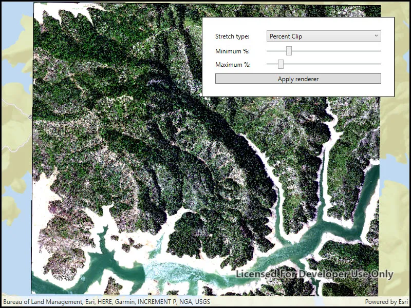
Apply an RGB renderer to a raster layer to enhance feature visibility.
Use case
An RGB renderer is used to adjust the color bands of a multispectral image. Remote sensing images acquired from satellites often contain values representing the reflection of multiple spectrums of light. Changing the RGB renderer of such rasters can be used to differentiate and highlight particular features that reflect light differently, such as different vegetation types, or turbidity in water.
How to use the sample
Choose one of the stretch parameter types. The other options will adjust based on the chosen type. Add your inputs and select the ‘Update’ button to update the renderer.
How it works
- Create a
Rasterfrom a from a multispectral raster file. - Create a
RasterLayerfrom the raster. - Create a
Basemapfrom the raster layer and set it to the map. - Create an
RGBRenderer, specifying theStretchParametersand other properties. - Apply the renderer to the raster layer.
Relevant API
- Basemap
- Raster
- RasterLayer
- RGBRenderer
- StretchParameters
Offline data
This sample downloads the following items from ArcGIS Online automatically:
- raster-file.zip - Tif raster file
About the data
The raster used in this sample shows an area in the south of the Shasta-Trinity National Forest, California.
Tags
analysis, color, composite, imagery, multiband, multispectral, pan-sharpen, photograph, raster, spectrum, stretch, visualization
Sample code
// Copyright 2018 Esri.//// Licensed under the Apache License, Version 2.0 (the "License"); you may not use this file except in compliance with the License.// You may obtain a copy of the License at: http://www.apache.org/licenses/LICENSE-2.0//// Unless required by applicable law or agreed to in writing, software distributed under the License is distributed on an// "AS IS" BASIS, WITHOUT WARRANTIES OR CONDITIONS OF ANY KIND, either express or implied. See the License for the specific// language governing permissions and limitations under the License.
using ArcGIS.Samples.Managers;using Esri.ArcGISRuntime.Mapping;using Esri.ArcGISRuntime.Rasters;using System;using System.Collections.Generic;using System.Linq;using System.Threading.Tasks;using System.Windows;using System.Windows.Controls;
namespace ArcGIS.WPF.Samples.RasterRgbRenderer{    [ArcGIS.Samples.Shared.Attributes.Sample(        name: "RGB renderer",        category: "Layers",        description: "Apply an RGB renderer to a raster layer to enhance feature visibility.",        instructions: "Choose one of the stretch parameter types. The other options will adjust based on the chosen type. Add your inputs and select the 'Update' button to update the renderer.",        tags: new[] { "analysis", "color", "composite", "imagery", "multiband", "multispectral", "pan-sharpen", "photograph", "raster", "spectrum", "stretch", "visualization" })]    [ArcGIS.Samples.Shared.Attributes.OfflineData("7c4c679ab06a4df19dc497f577f111bd")]    public partial class RasterRgbRenderer    {        // A reference to the raster layer to render.        private RasterLayer _rasterLayer;
        public RasterRgbRenderer()        {            InitializeComponent();
            // Call a function to create the map, add a raster layer, and fill UI controls.            _ = Initialize();        }
        private async Task Initialize()        {            // Create a map with a streets basemap.            Map map = new Map(BasemapStyle.ArcGISStreets);
            // Get the file name for the local raster dataset.            string filepath = GetRasterPath();
            // Load the raster file            Raster rasterFile = new Raster(filepath);
            // Create a new raster layer to show the image.            _rasterLayer = new RasterLayer(rasterFile);
            try            {                // Once the layer is loaded, enable the button to apply a new renderer.                await _rasterLayer.LoadAsync();                ApplyRgbRendererButton.IsEnabled = true;
                // Create a viewpoint with the raster's full extent.                Viewpoint fullRasterExtent = new Viewpoint(_rasterLayer.FullExtent);
                // Set the initial viewpoint for the map.                map.InitialViewpoint = fullRasterExtent;
                // Add the layer to the map.                map.OperationalLayers.Add(_rasterLayer);
                // Add the map to the map view.                MyMapView.Map = map;
                // Add available stretch types to the combo box.                StretchTypeComboBox.Items.Add("Min Max");                StretchTypeComboBox.Items.Add("Percent Clip");                StretchTypeComboBox.Items.Add("Standard Deviation");
                // Select "Min Max" as the stretch type.                StretchTypeComboBox.SelectedIndex = 0;
                // Create a range of values from 0-255.                List<int> minMaxValues = Enumerable.Range(0, 256).ToList();
                // Fill the min and max red combo boxes with the range and set default values.                MinRedComboBox.ItemsSource = minMaxValues;                MinRedComboBox.SelectedValue = 0;                MaxRedComboBox.ItemsSource = minMaxValues;                MaxRedComboBox.SelectedValue = 255;
                // Fill the min and max green combo boxes with the range and set default values.                MinGreenComboBox.ItemsSource = minMaxValues;                MinGreenComboBox.SelectedValue = 0;                MaxGreenComboBox.ItemsSource = minMaxValues;                MaxGreenComboBox.SelectedValue = 255;
                // Fill the min and max blue combo boxes with the range and set default values.                MinBlueComboBox.ItemsSource = minMaxValues;                MinBlueComboBox.SelectedValue = 0;                MaxBlueComboBox.ItemsSource = minMaxValues;                MaxBlueComboBox.SelectedValue = 255;
                // Fill the standard deviation factor combo box and set a default value.                IEnumerable<int> wholeStdDevs = Enumerable.Range(1, 10);                List<double> halfStdDevs = wholeStdDevs.Select(i => (double)i / 2).ToList();                StdDeviationFactorComboBox.ItemsSource = halfStdDevs;                StdDeviationFactorComboBox.SelectedValue = 2.0;            }            catch (Exception e)            {                MessageBox.Show(e.ToString(), "Error");            }        }
        private void ApplyRgbRendererButton_Click(object sender, System.Windows.RoutedEventArgs e)        {            // Create the correct type of StretchParameters with the corresponding user inputs.            StretchParameters stretchParameters = null;
            // See which type is selected and apply the corresponding input parameters to create the renderer.            switch (StretchTypeComboBox.SelectedValue.ToString())            {                case "Min Max":                    // Read the minimum and maximum values for the red, green, and blue bands.                    double minRed = Convert.ToDouble(MinRedComboBox.SelectedValue);                    double minGreen = Convert.ToDouble(MinGreenComboBox.SelectedValue);                    double minBlue = Convert.ToDouble(MinBlueComboBox.SelectedValue);                    double maxRed = Convert.ToDouble(MaxRedComboBox.SelectedValue);                    double maxGreen = Convert.ToDouble(MaxGreenComboBox.SelectedValue);                    double maxBlue = Convert.ToDouble(MaxBlueComboBox.SelectedValue);
                    // Create an array of the minimum and maximum values.                    double[] minValues = { minRed, minGreen, minBlue };                    double[] maxValues = { maxRed, maxGreen, maxBlue };
                    // Create a new MinMaxStretchParameters with the values.                    stretchParameters = new MinMaxStretchParameters(minValues, maxValues);                    break;
                case "Percent Clip":                    // Get the percentile cutoff below which values in the raster dataset are to be clipped.                    double minimumPercent = MinimumValueSlider.Value;
                    // Get the percentile cutoff above which pixel values in the raster dataset are to be clipped.                    double maximumPercent = MaximumValueSlider.Value;
                    // Create a new PercentClipStretchParameters with the inputs.                    stretchParameters = new PercentClipStretchParameters(minimumPercent, maximumPercent);                    break;
                case "Standard Deviation":                    // Read the standard deviation factor (the number of standard deviations used to define the range of pixel values).                    double standardDeviationFactor = Convert.ToDouble(StdDeviationFactorComboBox.SelectedValue);
                    // Create a new StandardDeviationStretchParameters with the selected number of standard deviations.                    stretchParameters = new StandardDeviationStretchParameters(standardDeviationFactor);                    break;            }
            // Create an array to specify the raster bands (red, green, blue).            int[] bands = { 0, 1, 2 };
            // Create the RgbRenderer with the stretch parameters created above, then apply it to the raster layer.            RgbRenderer rasterRenderer = new RgbRenderer(stretchParameters, bands, null, true);            _rasterLayer.Renderer = rasterRenderer;        }
        private void StretchTypeComboBox_SelectionChanged(object sender, SelectionChangedEventArgs e)        {            // Hide all UI controls for the input parameters.            MinMaxParametersGrid.Visibility = System.Windows.Visibility.Collapsed;            PercentClipParametersGrid.Visibility = System.Windows.Visibility.Collapsed;            StdDeviationParametersGrid.Visibility = System.Windows.Visibility.Collapsed;
            // See which type was selected and show the corresponding input controls.            switch (StretchTypeComboBox.SelectedValue.ToString())            {                case "Min Max":                    MinMaxParametersGrid.Visibility = System.Windows.Visibility.Visible;                    break;
                case "Percent Clip":                    PercentClipParametersGrid.Visibility = System.Windows.Visibility.Visible;                    break;
                case "Standard Deviation":                    StdDeviationParametersGrid.Visibility = System.Windows.Visibility.Visible;                    break;            }        }
private static string GetRasterPath() { return DataManager.GetDataFolder("7c4c679ab06a4df19dc497f577f111bd", "raster-file", "Shasta.tif"); } }}<UserControl x:Class="ArcGIS.WPF.Samples.RasterRgbRenderer.RasterRgbRenderer" xmlns="http://schemas.microsoft.com/winfx/2006/xaml/presentation" xmlns:x="http://schemas.microsoft.com/winfx/2006/xaml" xmlns:esri="http://schemas.esri.com/arcgis/runtime/2013"> <UserControl.Resources> <Style TargetType="TextBlock"> <Setter Property="Margin" Value="5" /> <Setter Property="VerticalAlignment" Value="Center" /> </Style> <Style TargetType="ComboBox" BasedOn="{StaticResource CalciteComboBoxStyle}"> <Setter Property="Margin" Value="5" /> <Setter Property="HorizontalAlignment" Value="Stretch" /> <Setter Property="VerticalAlignment" Value="Center" /> <Setter Property="MaxHeight" Value="25" /> <Setter Property="MinWidth" Value="64" /> </Style> <Style TargetType="Slider" BasedOn="{StaticResource CalciteSliderStyle}"> <Setter Property="VerticalAlignment" Value="Center" /> </Style> </UserControl.Resources> <Grid> <esri:MapView x:Name="MyMapView" /> <Border Style="{StaticResource BorderStyle}"> <Grid> <Grid.RowDefinitions> <RowDefinition Height="Auto" /> <RowDefinition Height="Auto" /> <RowDefinition Height="*" /> </Grid.RowDefinitions> <Grid.ColumnDefinitions> <ColumnDefinition Width="100" /> <ColumnDefinition Width="*" /> </Grid.ColumnDefinitions> <!-- Stretch type selection --> <TextBlock Grid.Row="0" Grid.Column="0" Text="Stretch type: " /> <ComboBox x:Name="StretchTypeComboBox" Grid.Row="0" Grid.Column="1" HorizontalAlignment="Stretch" SelectionChanged="StretchTypeComboBox_SelectionChanged" /> <!-- Min/Max form --> <Grid x:Name="MinMaxParametersGrid" Grid.Row="1" Grid.Column="0" Grid.ColumnSpan="2" Visibility="Visible"> <Grid.RowDefinitions> <RowDefinition Height="Auto" /> <RowDefinition Height="Auto" /> </Grid.RowDefinitions> <Grid.ColumnDefinitions> <ColumnDefinition Width="100" /> <ColumnDefinition /> <ColumnDefinition /> <ColumnDefinition /> </Grid.ColumnDefinitions> <TextBlock Grid.Row="0" Grid.Column="0" Text="Min value: " /> <ComboBox x:Name="MinRedComboBox" Grid.Row="0" Grid.Column="1" Foreground="Red" /> <ComboBox x:Name="MinGreenComboBox" Grid.Row="0" Grid.Column="2" Foreground="Green" /> <ComboBox x:Name="MinBlueComboBox" Grid.Row="0" Grid.Column="3" Foreground="Blue" /> <TextBlock Grid.Row="1" Grid.Column="0" Text="Max value: " /> <ComboBox x:Name="MaxRedComboBox" Grid.Row="1" Grid.Column="1" Foreground="Red" /> <ComboBox x:Name="MaxGreenComboBox" Grid.Row="1" Grid.Column="2" Foreground="Green" /> <ComboBox x:Name="MaxBlueComboBox" Grid.Row="1" Grid.Column="3" Foreground="Blue" /> </Grid> <!-- Percent clip form --> <Grid x:Name="PercentClipParametersGrid" Grid.Row="1" Grid.Column="0" Grid.ColumnSpan="2" Visibility="Collapsed"> <Grid.RowDefinitions> <RowDefinition Height="Auto" /> <RowDefinition Height="Auto" /> </Grid.RowDefinitions> <Grid.ColumnDefinitions> <ColumnDefinition Width="100" /> <ColumnDefinition Width="*" /> </Grid.ColumnDefinitions> <TextBlock Grid.Row="0" Grid.Column="0" Text="Minimum %: " /> <Slider x:Name="MinimumValueSlider" Grid.Row="0" Grid.Column="1" Maximum="100" Minimum="0" /> <TextBlock Grid.Row="1" Grid.Column="0" Text="Maximum %: " /> <Slider x:Name="MaximumValueSlider" Grid.Row="1" Grid.Column="1" Maximum="100" Minimum="0" /> </Grid> <!-- Standard deviation form --> <Grid x:Name="StdDeviationParametersGrid" Grid.Row="1" Grid.Column="0" Grid.ColumnSpan="2" Visibility="Collapsed"> <Grid.ColumnDefinitions> <ColumnDefinition Width="100" /> <ColumnDefinition Width="*" /> </Grid.ColumnDefinitions> <TextBlock Grid.Row="0" Grid.Column="0" Text="Factor:" /> <ComboBox x:Name="StdDeviationFactorComboBox" Grid.Row="0" Grid.Column="1" /> </Grid> <!-- Apply button --> <Button x:Name="ApplyRgbRendererButton" Grid.Row="2" Grid.Column="0" Grid.ColumnSpan="2" Margin="5" Click="ApplyRgbRendererButton_Click" Content="Apply renderer" IsEnabled="False" /> </Grid> </Border> </Grid></UserControl>