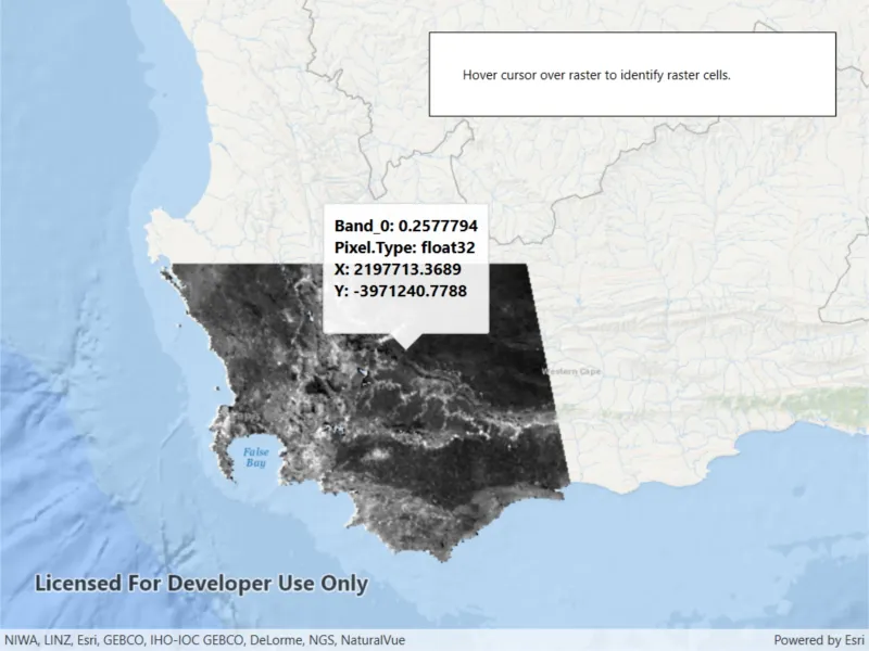
Get the cell value of a local raster at the tapped location and display the result in a callout.
Use case
You may want to identify a raster layer to get its exact cell value in the case the approximate value conveyed by its symbology is not sufficient. The information available for the raster cell depends on the type of raster layer being identified. For example, a 3-band satellite or aerial image might provide 8-bit RGB values, whereas a digital elevation model (DEM) would provide floating point z values. By identifying a raster cell of a DEM, you can retrieve the precise elevation of a location.
How to use the sample
Tap or move your cursor over an area of the raster to identify a raster cell and display it’s attributes in a callout.
How it works
- Create a
GeoViewTappedevent on theMapView. - On tap:
- Call
IdentifyLayerAsyncpassing in the screen point, tolerance, and maximum number of results per layer. - Await the result of the identify and then get the
GeoElementfrom the layer result. - Create a callout at the calculated map point and populate the callout content with text from the
RasterCellattributes.
Relevant API
- GeoView.IdentifyLayerAsync
- IdentifyLayerResult
- RasterCell
- RasterCell.Attributes
- RasterLayer
Offline data
This sample uses MODIS raster imagery. Data is downloaded from ArcGIS Online automatically.
About the data
The data shown is an NDVI classification derived from MODIS imagery between 27 Apr 2020 and 4 May 2020. It comes from the NASA Worldview application. In a normalized difference vegetation index, or NDVI, values range between -1 and +1 with the positive end of the spectrum showing green vegetation.
Tags
band, cell, cell value, continuous, discrete, identify, NDVI, pixel, pixel value, raster
Sample code
// Copyright 2020 Esri.//// Licensed under the Apache License, Version 2.0 (the "License"); you may not use this file except in compliance with the License.// You may obtain a copy of the License at: http://www.apache.org/licenses/LICENSE-2.0//// Unless required by applicable law or agreed to in writing, software distributed under the License is distributed on an// "AS IS" BASIS, WITHOUT WARRANTIES OR CONDITIONS OF ANY KIND, either express or implied. See the License for the specific// language governing permissions and limitations under the License.
using ArcGIS.Samples.Managers;using Esri.ArcGISRuntime.Data;using Esri.ArcGISRuntime.Mapping;using Esri.ArcGISRuntime.Rasters;using Esri.ArcGISRuntime.UI;using System;using System.Collections.Generic;using System.Linq;using System.Text;using System.Threading.Tasks;using System.Windows;using System.Windows.Input;
namespace ArcGIS.WPF.Samples.IdentifyRasterCell{    [ArcGIS.Samples.Shared.Attributes.Sample(        name: "Identify raster cell",        category: "Layers",        description: "Get the cell value of a local raster at the tapped location and display the result in a callout.",        instructions: "Tap or move your cursor over an area of the raster to identify a raster cell and display it's attributes in a callout.",        tags: new[] { "NDVI", "band", "cell", "cell value", "continuous", "discrete", "identify", "pixel", "pixel value", "raster" })]    [ArcGIS.Samples.Shared.Attributes.OfflineData("b5f977c78ec74b3a8857ca86d1d9b318")]    public partial class IdentifyRasterCell    {        // Raster layer to display raster data on the map.        private RasterLayer _rasterLayer;
        // Boolean to prevent concurrent identify calls.        private bool _isIdentifying = false;
        // Store the next identify cell task.        private Action _nextIdentifyAction = null;
        public IdentifyRasterCell()        {            InitializeComponent();            _ = Initialize();        }
        private async Task Initialize()        {            // Define a new map with Wgs84 Spatial Reference.            var map = new Map(BasemapStyle.ArcGISOceans);            map.InitialViewpoint = new Viewpoint(-34.1, 18.6, 9);
            // Get the file name for the raster.            string filepath = DataManager.GetDataFolder("b5f977c78ec74b3a8857ca86d1d9b318", "SA_EVI_8Day_03May20.tif");
            // Load the raster file.            var raster = new Raster(filepath);
            // Initialize the raster layer.            _rasterLayer = new RasterLayer(raster);
            // Add the raster layer to the map.            map.OperationalLayers.Add(_rasterLayer);
            // Add map to the map view.            MyMapView.Map = map;
            try            {                // Wait for the layer to load.                await _rasterLayer.LoadAsync();
                // Set the viewpoint.                await MyMapView.SetViewpointGeometryAsync(_rasterLayer.FullExtent);            }            catch (Exception ex)            {                MessageBox.Show(ex.Message, ex.GetType().ToString());            }
            // Listen for mouse movement to start the identify operation.            MyMapView.MouseMove += MouseMoved;
            // Disable magnifier.            MyMapView.InteractionOptions = new MapViewInteractionOptions            {                IsMagnifierEnabled = false            };        }
        private void MouseMoved(object sender, MouseEventArgs mouseArgs)        {            // Get the curent mouse position.            Point position = mouseArgs.GetPosition(MyMapView);
            // Identify the raster cell at that position.            _ = IdentifyCell(position);        }
        private async Task IdentifyCell(Point position)        {            // Check if a cell is already being identified.            if (_isIdentifying)            {                _nextIdentifyAction = () => _ = IdentifyCell(position);                return;            }
            // Set variable to true to prevent concurrent identify calls.            _isIdentifying = true;
            try            {                // Get the result for where the user hovered on the raster layer.                IdentifyLayerResult identifyResult = await MyMapView.IdentifyLayerAsync(_rasterLayer, position, 1, false, 1);
                // If no cell was identified, dismiss the callout.                if (!identifyResult.GeoElements.Any())                {                    MyMapView.DismissCallout();                    return;                }
                // Create a StringBuilder to display information to the user.                var stringBuilder = new StringBuilder();
                // Get the identified raster cell.                GeoElement cell = identifyResult.GeoElements.First();
                // Loop through the attributes (key/value pairs).                foreach (KeyValuePair<string, object> keyValuePair in cell.Attributes)                {                    // Add the key/value pair to the string builder.                    stringBuilder.AppendLine($"{keyValuePair.Key}: {keyValuePair.Value}");                }
                // Get the x and y values of the cell.                double x = cell.Geometry.Extent.XMin;                double y = cell.Geometry.Extent.YMin;
                // Add the X & Y coordinates where the user clicked raster cell to the string builder.                stringBuilder.AppendLine($"X: {Math.Round(x, 4)}\nY: {Math.Round(y, 4)}");
                // Create a callout using the string.                var definition = new CalloutDefinition(stringBuilder.ToString());
                // Display the call out in the map view.                MyMapView.ShowCalloutAt(MyMapView.ScreenToLocation(position), definition);            }            catch (Exception ex)            {                MessageBox.Show(ex.Message, ex.GetType().ToString());            }            finally            {                _isIdentifying = false;            }
            // Check if there is a new position to identify.            if (_nextIdentifyAction != null)            {                Action action = _nextIdentifyAction;
                // Clear the queued identify action.                _nextIdentifyAction = null;
// Run the next action. action(); } } }}<UserControl x:Class="ArcGIS.WPF.Samples.IdentifyRasterCell.IdentifyRasterCell" xmlns="http://schemas.microsoft.com/winfx/2006/xaml/presentation" xmlns:x="http://schemas.microsoft.com/winfx/2006/xaml" xmlns:esri="http://schemas.esri.com/arcgis/runtime/2013"> <Grid> <esri:MapView x:Name="MyMapView" /> <Border Style="{StaticResource BorderStyle}"> <Label Margin="5" Content="Hover cursor over raster to identify raster cells." /> </Border> </Grid></UserControl>