Change the style of a Web Map Service (WMS) layer.
Use case
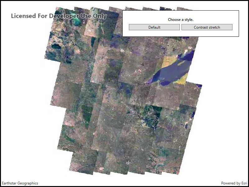
Layers hosted on WMS may have different pre-set styles available to apply to them. Swapping between these styles can help during visual examination of the data. For example, increasing the contrast of satellite images can help in identifying urban and agricultural areas within forested areas.
How to use the sample
Once the layer loads, the toggle button will be enabled. Click it to toggle between the first and second styles of the WMS layer.
How it works
- Create a
WmsLayerspecifying the URL of the service and the layer names you wantnew WmsLayer(url, names). - When the layer is done loading, get it’s list of style strings using
wmsLayer.Sublayers[0].SublayerInfo.Styles. - Set one of the styles using the
wmsLayer.Sublayers[0].CurrentStyleproperty.
Relevant API
- WmsLayer
- WmsSublayer
- WmsSublayerInfo
About the data
This sample uses a public service managed by the State of Minnesota and provides composite imagery for the state and the surrounding areas.
Tags
imagery, styles, visualization, WMS
Sample code
// Copyright 2018 Esri.//// Licensed under the Apache License, Version 2.0 (the "License"); you may not use this file except in compliance with the License.// You may obtain a copy of the License at: http://www.apache.org/licenses/LICENSE-2.0//// Unless required by applicable law or agreed to in writing, software distributed under the License is distributed on an// "AS IS" BASIS, WITHOUT WARRANTIES OR CONDITIONS OF ANY KIND, either express or implied. See the License for the specific// language governing permissions and limitations under the License.
using Esri.ArcGISRuntime.Geometry;using Esri.ArcGISRuntime.Mapping;using System;using System.Collections.Generic;using System.Threading.Tasks;using System.Windows;
namespace ArcGIS.WPF.Samples.StyleWmsLayer{    [ArcGIS.Samples.Shared.Attributes.Sample(        name: "Style WMS layers",        category: "Layers",        description: "Change the style of a Web Map Service (WMS) layer.",        instructions: "Once the layer loads, the toggle button will be enabled. Click it to toggle between the first and second styles of the WMS layer.",        tags: new[] { "WMS", "imagery", "styles", "visualization" })]    public partial class StyleWmsLayer    {        // Hold the URL to the service, which has satellite imagery covering the state of Minnesota.        private Uri _wmsUrl = new Uri("https://imageserver.gisdata.mn.gov/cgi-bin/mncomp?SERVICE=WMS&VERSION=1.3.0&REQUEST=GetCapabilities");
        // Hold a list of uniquely-identifying WMS layer names to display.        private List<String> _wmsLayerNames = new List<string> { "mncomp" };
        // Hold a reference to the layer to enable re-styling.        private WmsLayer _mnWmsLayer;
        public StyleWmsLayer()        {            InitializeComponent();            _ = Initialize();        }
        private async Task Initialize()        {            try            {                // Create a map with spatial reference appropriate for the service.                Map myMap = new Map(SpatialReference.Create(26915)) { MinScale = 7000000.0 };
                // Create a new WMS layer displaying the specified layers from the service.                // The default styles are chosen by default.                _mnWmsLayer = new WmsLayer(_wmsUrl, _wmsLayerNames);
                // Wait for the layer to load.                await _mnWmsLayer.LoadAsync();
                // Center the map on the layer's contents.                myMap.InitialViewpoint = new Viewpoint(_mnWmsLayer.FullExtent);
                // Add the layer to the map.                myMap.OperationalLayers.Add(_mnWmsLayer);
                // Add the map to the view.                MyMapView.Map = myMap;
                // Enable the buttons.                FirstStyleButton.IsEnabled = true;                SecondStyleButton.IsEnabled = true;            }            catch (Exception ex)            {                MessageBox.Show(ex.ToString(), "Error");            }        }
        private void FirstStyleButton_Clicked(object sender, RoutedEventArgs e)        {            // Get the available styles from the first sublayer.            IReadOnlyList<string> styles = _mnWmsLayer.Sublayers[0].SublayerInfo.Styles;
            // Apply the first style to the first sublayer.            _mnWmsLayer.Sublayers[0].CurrentStyle = styles[0];        }
        private void SecondStyleButton_Clicked(object sender, RoutedEventArgs e)        {            // Get the available styles from the first sublayer.            IReadOnlyList<string> styles = _mnWmsLayer.Sublayers[0].SublayerInfo.Styles;
// Apply the second style to the first sublayer. _mnWmsLayer.Sublayers[0].CurrentStyle = styles[1]; } }}<UserControl x:Class="ArcGIS.WPF.Samples.StyleWmsLayer.StyleWmsLayer" xmlns="http://schemas.microsoft.com/winfx/2006/xaml/presentation" xmlns:x="http://schemas.microsoft.com/winfx/2006/xaml" xmlns:esri="http://schemas.esri.com/arcgis/runtime/2013"> <Grid> <esri:MapView x:Name="MyMapView" /> <Border Style="{StaticResource BorderStyle}"> <Grid> <Grid.RowDefinitions> <RowDefinition Height="Auto" /> <RowDefinition Height="Auto" /> </Grid.RowDefinitions> <Grid.ColumnDefinitions> <ColumnDefinition Width="*" /> <ColumnDefinition Width="*" /> </Grid.ColumnDefinitions> <TextBlock Grid.Row="0" Grid.Column="0" Grid.ColumnSpan="2" Margin="0,0,0,2" FontWeight="SemiBold" Text="Choose a style." TextAlignment="Center" TextWrapping="Wrap" /> <Button x:Name="FirstStyleButton" Grid.Row="1" Grid.Column="0" Margin="0,5,2.5,0" Click="FirstStyleButton_Clicked" Content="Default" IsEnabled="False" /> <Button x:Name="SecondStyleButton" Grid.Row="1" Grid.Column="1" Margin="2.5,5,0,0" Click="SecondStyleButton_Clicked" Content="Contrast stretch" IsEnabled="False" /> </Grid> </Border> </Grid></UserControl>