View an integrated mesh layer from a scene service.
Use case
An integrated mesh is used to generate a mesh over a point dataset. They are most often used on high-density point datasets to create a high-resolution seamless surface.
How to use the sample
After launching the sample, watch the integrated mesh layer load in place. Navigate around the scene to visualize the high level of detail on the buildings.
How it works
- Create a
Scene. - Create an
IntegratedMeshLayerwith the URL to an integrated mesh layer scene service. - Add the layer to the scene’s operational layers.
- Create an
Cameraobject and set it as the viewpoint camera of the scene view.
Relevant API
- IntegratedMeshLayer
About the data
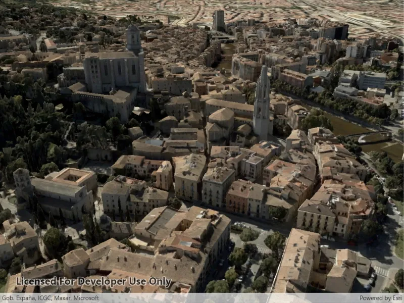
This integrated mesh depicts the city of Girona, Spain and is attributed to the Institut Cartogràfic i Geològic de Catalunya (ICGC). The data was produced from photogrammetrically correct imagery. Areas of white space within the integrated mesh are areas that had poor overlapping coverage from photos.
Additional information
An integrated mesh layer can also be added to a scene from a local data source - either from a scene layer package (.slpk) or a mobile scene package (.mspk).
Tags
3D, integrated mesh, layers
Sample code
// Copyright 2021 Esri.//// Licensed under the Apache License, Version 2.0 (the "License"); you may not use this file except in compliance with the License.// You may obtain a copy of the License at: http://www.apache.org/licenses/LICENSE-2.0//// Unless required by applicable law or agreed to in writing, software distributed under the License is distributed on an// "AS IS" BASIS, WITHOUT WARRANTIES OR CONDITIONS OF ANY KIND, either express or implied. See the License for the specific// language governing permissions and limitations under the License.
using Esri.ArcGISRuntime.Geometry;using Esri.ArcGISRuntime.Mapping;using System;
namespace ArcGIS.WPF.Samples.AddAnIntegratedMeshLayer{    [ArcGIS.Samples.Shared.Attributes.Sample(        name: "Add integrated mesh layer",        category: "Layers",        description: "View an integrated mesh layer from a scene service.",        instructions: "After launching the sample, watch the integrated mesh layer load in place. Navigate around the scene to visualize the high level of detail on the buildings.",        tags: new[] { "3D", "integrated mesh", "layers" })]    public partial class AddAnIntegratedMeshLayer    {        // URLs for the services used by this sample.        private const string IntegratedMeshLayerUrl =            "https://tiles.arcgis.com/tiles/z2tnIkrLQ2BRzr6P/arcgis/rest/services/Girona_Spain/SceneServer";
        private const string ElevationServiceUrl = "https://elevation3d.arcgis.com/arcgis/rest/services/WorldElevation3D/Terrain3D/ImageServer";
        public AddAnIntegratedMeshLayer()        {            InitializeComponent();            Initialize();        }
        private void Initialize()        {            // Create the scene with basemap.            MySceneView.Scene = new Scene(BasemapStyle.ArcGISImageryStandard);
            // Create and use an elevation surface to show terrain.            Surface baseSurface = new Surface();            baseSurface.ElevationSources.Add(new ArcGISTiledElevationSource(new Uri(ElevationServiceUrl)));            MySceneView.Scene.BaseSurface = baseSurface;
            // Create the integrated mesh layer from URL.            IntegratedMeshLayer meshLayer = new IntegratedMeshLayer(new Uri(IntegratedMeshLayerUrl));
            // Add the layer to the scene's operational layers.            MySceneView.Scene.OperationalLayers.Add(meshLayer);
// Start with camera pointing at the scene. MySceneView.SetViewpointCamera(new Camera(new MapPoint(2.8259, 41.9906, 200.0), 190, 65, 0)); } }}<UserControl x:Class="ArcGIS.WPF.Samples.AddAnIntegratedMeshLayer.AddAnIntegratedMeshLayer" xmlns="http://schemas.microsoft.com/winfx/2006/xaml/presentation" xmlns:x="http://schemas.microsoft.com/winfx/2006/xaml" xmlns:esri="http://schemas.esri.com/arcgis/runtime/2013"> <Grid> <esri:SceneView x:Name="MySceneView" /> </Grid></UserControl>