Query data using a time extent.
Use case
This workflow can be used to return records that are between a specified start and end date. For example, records of Canada goose sightings over time could be queried to only show sightings during the winter migration time period.
How to use the sample
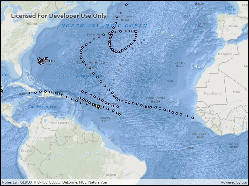
Run the sample, and a subset of records will be displayed on the map.
How it works
- An instance of
ServiceFeatureTableis created by passing a URL to the REST endpoint of a time-enabled service. Time-enabled services will have TimeInfo defined in the service description. This information is specified in ArcGIS Pro prior to publishing the service. - The feature request mode of the
ServiceFeatureTableis set toManualCache, so that the developer can control how and when the feature table is populated with data. - A
FeatureLayeris created by passing in the instance of theServiceFeatureTable. - A
TimeExtentobject is created by specifying start and end date/time objects. - A
QueryParmatersobject is created with theTimeExtent. ServiceFeatureTable.PopulateFromServiceis executed by passing in theQueryParameters.- The feature table is populated with data that matches the provided query.
Relevant API
- QueryParameters
- ServiceFeatureTable.PopulateFromService
- TimeExtent
About the data
This sample uses Atlantic hurricane data from the year 2000. The data is from the National Hurricane Center (NOAA / National Weather Service).
Tags
query, time, time extent
Sample code
// Copyright 2017 Esri.//// Licensed under the Apache License, Version 2.0 (the "License"); you may not use this file except in compliance with the License.// You may obtain a copy of the License at: http://www.apache.org/licenses/LICENSE-2.0//// Unless required by applicable law or agreed to in writing, software distributed under the License is distributed on an// "AS IS" BASIS, WITHOUT WARRANTIES OR CONDITIONS OF ANY KIND, either express or implied. See the License for the specific// language governing permissions and limitations under the License.
using Esri.ArcGISRuntime;using Esri.ArcGISRuntime.Data;using Esri.ArcGISRuntime.Mapping;using System;using System.Windows;
namespace ArcGIS.WPF.Samples.TimeBasedQuery{    [ArcGIS.Samples.Shared.Attributes.Sample(        name: "Time-based query",        category: "Layers",        description: "Query data using a time extent.",        instructions: "Run the sample, and a subset of records will be displayed on the map.",        tags: new[] { "query", "time", "time extent" })]    public partial class TimeBasedQuery    {        // Hold a URI pointing to the feature service        private Uri _serviceUri = new Uri("https://sampleserver6.arcgisonline.com/arcgis/rest/services/Hurricanes/MapServer/0");
        // Hold a reference to the feature table used by the sample        private ServiceFeatureTable _myFeatureTable;
        public TimeBasedQuery()        {            InitializeComponent();
            // Create the UI, setup the control references and execute initialization            Initialize();        }
        private void Initialize()        {            // Create a new map with oceans basemap            Map myMap = new Map(BasemapStyle.ArcGISOceans);
            // Create feature table for the hurricane feature service            _myFeatureTable = new ServiceFeatureTable(_serviceUri)            {                // Define the request mode                FeatureRequestMode = FeatureRequestMode.ManualCache            };
            // When feature table is loaded, populate data            _myFeatureTable.LoadStatusChanged += OnLoadedPopulateData;
            // Create FeatureLayer that uses the created table            FeatureLayer myFeatureLayer = new FeatureLayer(_myFeatureTable);
            // Add created layer to the map            myMap.OperationalLayers.Add(myFeatureLayer);
            // Assign the Map to the MapView            MyMapView.Map = myMap;        }
        private async void OnLoadedPopulateData(object sender, LoadStatusEventArgs e)        {            // If layer isn't loaded, do nothing            if (e.Status != LoadStatus.Loaded) { return; }
            // Create new query object that contains a basic 'include everything' clause            QueryParameters queryParameters = new QueryParameters()            {                WhereClause = "1=1"            };
            // Create a new time extent that covers the desired interval (beginning of time to September 16th, 2000)            TimeExtent myExtent = new TimeExtent(new DateTime(1, 1, 1), new DateTime(2000, 9, 16));
            // Apply the time extent to the query parameters            queryParameters.TimeExtent = myExtent;
            // Create list of the fields that are returned from the service            string[] outputFields = { "*" };
try { // Populate feature table with the data based on query await _myFeatureTable.PopulateFromServiceAsync(queryParameters, true, outputFields); } catch (Exception ex) { MessageBox.Show(ex.ToString(), "Error"); } } }}<UserControl x:Class="ArcGIS.WPF.Samples.TimeBasedQuery.TimeBasedQuery" xmlns="http://schemas.microsoft.com/winfx/2006/xaml/presentation" xmlns:x="http://schemas.microsoft.com/winfx/2006/xaml" xmlns:esri="http://schemas.esri.com/arcgis/runtime/2013"> <Grid> <esri:MapView x:Name="MyMapView" /> </Grid></UserControl>