Connect to a service and list versions of the geodatabase.
Use case
As part of a multi-user editing scenario, you can check with the server to see how many versions of the geodatabase are outstanding before syncing.
How to use the sample
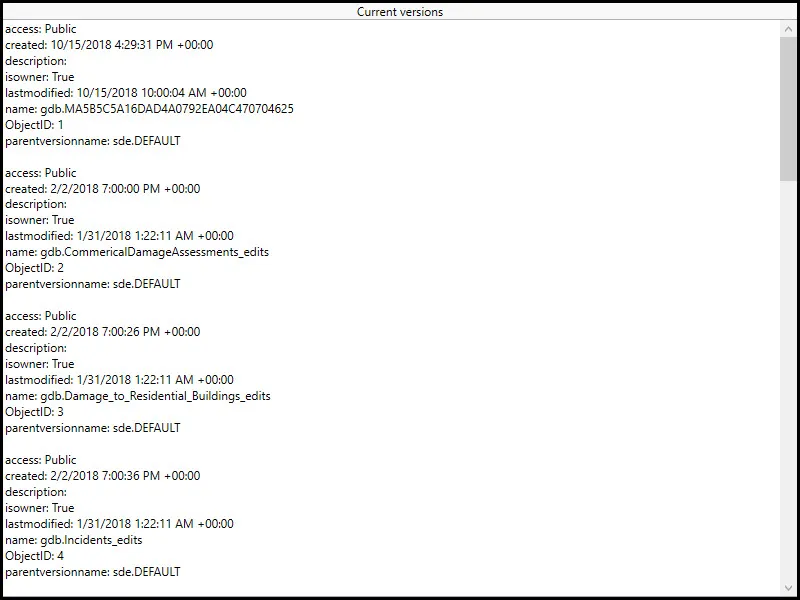
When the sample loads, a list of geodatabase versions and their properties will be displayed.
How it works
- Create a geoprocessing task referring to a GPServer with a ListVersions task.
- Use the task to create default parameters.
- Use the created parameters to create a job.
- Run the job to get a
GeoprocessingResult. - Get a list of geoprocessing features from the Versions output parameter of the results.
- Format the geodatabase versions for display.
Relevant API
- GeoprocessingFeatures
- GeoprocessingFeatures.Features
- GeoprocessingJob
- GeoprocessingJob.GetResultAsync
- GeoprocessingParameters
- GeoprocessingResult
- GeoprocessingResult.Outputs
- GeoprocessingTask
- GeoprocessingTask.CreateDefaultParametersAsync
- GeoprocessingTask.CreateJob
About the data
The sample uses a sample geoprocessing service hosted on ArcGIS Online.
Additional information
ArcGIS Server does not include a geoprocessing service for listing geodatabase versions. Instead, you must configure and publish one yourself using ArcGIS Pro. To learn more about geoprocessing services see Web tools and geoprocessing services in the ArcGIS Server documentation.
Tags
conflict resolution, data management, database, multi-user, sync, version
Sample code
// Copyright 2016 Esri.//// Licensed under the Apache License, Version 2.0 (the "License"); you may not use this file except in compliance with the License.// You may obtain a copy of the License at: http://www.apache.org/licenses/LICENSE-2.0//// Unless required by applicable law or agreed to in writing, software distributed under the License is distributed on an// "AS IS" BASIS, WITHOUT WARRANTIES OR CONDITIONS OF ANY KIND, either express or implied. See the License for the specific// language governing permissions and limitations under the License.
using Esri.ArcGISRuntime.Data;using Esri.ArcGISRuntime.Tasks;using Esri.ArcGISRuntime.Tasks.Geoprocessing;using System;using System.Collections.Generic;using System.Text;using System.Threading.Tasks;using System.Windows;
namespace ArcGIS.WPF.Samples.ListGeodatabaseVersions{    [ArcGIS.Samples.Shared.Attributes.Sample(        name: "List geodatabase versions",        category: "Geoprocessing",        description: "Connect to a service and list versions of the geodatabase.",        instructions: "When the sample loads, a list of geodatabase versions and their properties will be displayed.",        tags: new[] { "conflict resolution", "data management", "database", "multi-user", "sync", "version" })]    public partial class ListGeodatabaseVersions    {        // Url to used geoprocessing service        private const string ListVersionsUrl =            "https://sampleserver6.arcgisonline.com/arcgis/rest/services/GDBVersions/GPServer/ListVersions";
        public ListGeodatabaseVersions()        {            InitializeComponent();
            // Create the UI, setup the control references and execute initialization            _ = Initialize();        }
        private async Task Initialize()        {            // Set the UI to indicate that the geoprocessing is running            SetBusy(true);
            try            {                // Get versions from a geodatabase                IFeatureSet versionsFeatureSet = await GetGeodatabaseVersionsAsync();
                // Continue if we got a valid geoprocessing result                if (versionsFeatureSet != null)                {                    // Create a string builder to hold all of the information from the geoprocessing                    // task to display in the UI                    StringBuilder myStringBuilder = new StringBuilder();
                    // Loop through each Feature in the FeatureSet                    foreach (Feature version in versionsFeatureSet)                    {                        // Get the attributes (a dictionary of <key,value> pairs) from the Feature                        IDictionary<string, object> myDictionary = version.Attributes;
                        // Loop through each attribute (a <key,value> pair)                        foreach (KeyValuePair<string, object> attribute in myDictionary)                        {                            // Add the key and value strings to the string builder                            myStringBuilder.AppendLine(attribute.Key + ": " + attribute.Value);                        }
                        // Add a blank line after each Feature (the listing of geodatabase versions)                        myStringBuilder.AppendLine();                    }
                    // Display the result in the textbox                    ResultView.Text = myStringBuilder.ToString();                }            }            catch (Exception e)            {                MessageBox.Show(e.ToString(), "Error");            }
            // Set the UI to indicate that the geoprocessing is not running            SetBusy(false);        }
        private async Task<IFeatureSet> GetGeodatabaseVersionsAsync()        {            // Results will be returned as a feature set            IFeatureSet results = null;
            // Create new geoprocessing task            GeoprocessingTask listVersionsTask = await GeoprocessingTask.CreateAsync(new Uri(ListVersionsUrl));
            // Create default parameters that are passed to the geoprocessing task            GeoprocessingParameters listVersionsParameters = await listVersionsTask.CreateDefaultParametersAsync();
            // Create job that handles the communication between the application and the geoprocessing task            GeoprocessingJob listVersionsJob = listVersionsTask.CreateJob(listVersionsParameters);            try            {                // Execute analysis and wait for the results                GeoprocessingResult analysisResult = await listVersionsJob.GetResultAsync();
                // Get results from the outputs                GeoprocessingFeatures listVersionsResults = (GeoprocessingFeatures)analysisResult.Outputs["Versions"];
                // Set results                results = listVersionsResults.Features;            }            catch (Exception ex)            {                // Error handling if something goes wrong                if (listVersionsJob.Status == JobStatus.Failed && listVersionsJob.Error != null)                    MessageBox.Show("Executing geoprocessing failed. " + listVersionsJob.Error.Message, "Geoprocessing error");                else                    MessageBox.Show("An error occurred. " + ex.ToString(), "Sample error");            }            finally            {                // Set the UI to indicate that the geoprocessing is not running                SetBusy(false);            }
            return results;        }
private void SetBusy(bool isBusy = true) { if (isBusy) { // Change UI to indicate that the geoprocessing is running BusyOverlay.Visibility = Visibility.Visible; Progress.IsIndeterminate = true; } else { // Change UI to indicate that the geoprocessing is not running BusyOverlay.Visibility = Visibility.Collapsed; Progress.IsIndeterminate = false; } } }}<UserControl x:Class="ArcGIS.WPF.Samples.ListGeodatabaseVersions.ListGeodatabaseVersions" xmlns="http://schemas.microsoft.com/winfx/2006/xaml/presentation" xmlns:x="http://schemas.microsoft.com/winfx/2006/xaml" xmlns:esri="http://schemas.esri.com/arcgis/runtime/2013"> <Grid> <Grid> <Grid.RowDefinitions> <RowDefinition Height="Auto" /> <RowDefinition Height="*" /> </Grid.RowDefinitions> <TextBlock Grid.Row="0" HorizontalAlignment="Center" Text="Current versions" /> <TextBox x:Name="ResultView" Grid.Row="1" ScrollViewer.VerticalScrollBarVisibility="Visible" TextWrapping="Wrap" /> </Grid> <Grid x:Name="BusyOverlay" Grid.RowSpan="4" Background="#8C000000" Visibility="Collapsed"> <Border Padding="10" HorizontalAlignment="Center" VerticalAlignment="Center" Background="#FFC6C4C4"> <Grid> <ProgressBar x:Name="Progress" Height="20" IsIndeterminate="True" /> <TextBlock Height="Auto" Margin="5" HorizontalAlignment="Left" Text="Getting versions from the geoprocessing task..." /> </Grid> </Border> </Grid> </Grid></UserControl>