Add, remove, and reorder operational layers in a map.
Use case
Operational layers display the primary content of the map and usually provide dynamic content for the user to interact with (as opposed to basemap layers that provide context).
The order of operational layers in a map determines the visual hierarchy of layers in the view. You can bring attention to a specific layer by rendering above other layers.
How to use the sample
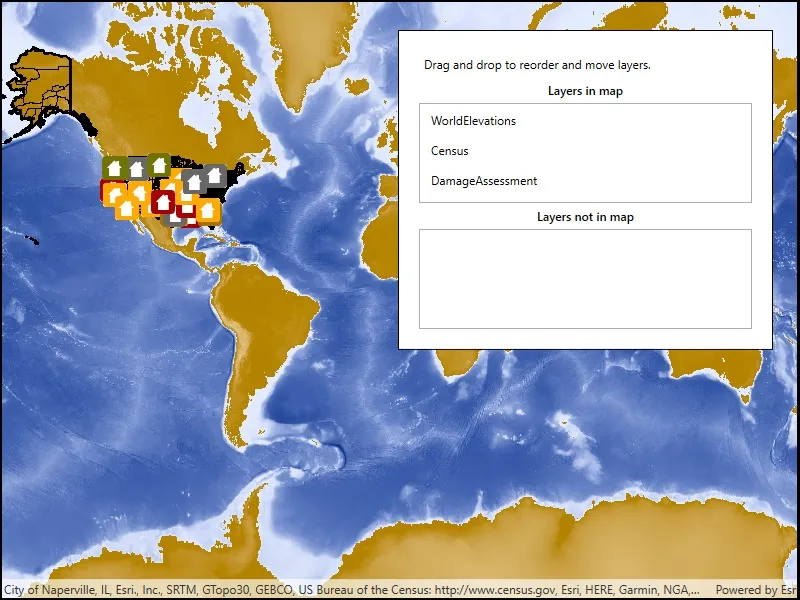
When the app starts, a list displays the operational layers that are currently displayed in the map. Right-click on the list item to remove the layer, or left-click to move it to the top. The map will be updated automatically.
The second list shows layers that have been removed from the map. Click one to add it to the map.
How it works
- Get the operational layers from the map using
map.OperationalLayers. - Add or remove layers using
layerList.Add(layer)andlayerList.Remove(layer)respectively. The last layer in the list will be rendered on top.
Relevant API
- ArcGISMapImageLayer
- Map
- MapView
- MapView.OperationalLayers
Additional information
You cannot add the same layer to the map multiple times or add the same layer to multiple maps. Instead, create a new layer using the FeatureTable.
Tags
add, delete, layer, map, remove
Sample code
// Copyright 2019 Esri.//// Licensed under the Apache License, Version 2.0 (the "License"); you may not use this file except in compliance with the License.// You may obtain a copy of the License at: http://www.apache.org/licenses/LICENSE-2.0//// Unless required by applicable law or agreed to in writing, software distributed under the License is distributed on an// "AS IS" BASIS, WITHOUT WARRANTIES OR CONDITIONS OF ANY KIND, either express or implied. See the License for the specific// language governing permissions and limitations under the License.
using Esri.ArcGISRuntime.Mapping;using System;using System.Windows;using System.Windows.Controls;using System.Windows.Input;using System.Windows.Media;
namespace ArcGIS.WPF.Samples.ManageOperationalLayers{    [ArcGIS.Samples.Shared.Attributes.Sample(        name: "Manage operational layers",        category: "Map",        description: "Add, remove, and reorder operational layers in a map.",        instructions: "When the app starts, a list displays the operational layers that are currently displayed in the map. Right-click on the list item to remove the layer, or left-click to move it to the top. The map will be updated automatically.",        tags: new[] { "add", "delete", "layer", "map", "remove" })]    public partial class ManageOperationalLayers    {        // The view model manages the data for the sample.        private MapViewModel _viewModel;
        // During drag and drop, keep track of which list the dragged item came from.        private ListBoxItem _originatingListBoxItem;
        // Some URLs of layers to add to the map.        private readonly string[] _layerUrls = new[]        {            "https://sampleserver5.arcgisonline.com/arcgis/rest/services/Elevation/WorldElevations/MapServer",            "https://sampleserver5.arcgisonline.com/arcgis/rest/services/Census/MapServer",            "https://sampleserver5.arcgisonline.com/arcgis/rest/services/DamageAssessment/MapServer"        };
        public ManageOperationalLayers()        {            InitializeComponent();            Initialize();        }
        private void Initialize()        {            _viewModel = new MapViewModel(new Map(BasemapStyle.ArcGISStreets));
            // Configure bindings to point to the view model.            this.DataContext = _viewModel;
            // Add the layers.            foreach (string layerUrl in _layerUrls)            {                _viewModel.AddLayerFromUrl(layerUrl);            }        }
        #region Drag and drop support
        private void ListBox_DragPreviewMove(object sender, MouseButtonEventArgs e)        {            // This method is called when the user clicks and starts dragging a listbox item.
            if (sender is ListBoxItem)            {                // Get the listbox item that is being moved.                ListBoxItem sendingItem = (ListBoxItem)sender;
                // Record that this item was being dragged - used later when drag ends to determine which item to move.                _originatingListBoxItem = sendingItem;
                // Register the start of the drag & drop operation with the system.                DragDrop.DoDragDrop(sendingItem, sendingItem.DataContext, DragDropEffects.Move);
                // Mark the dragged item as selected.                sendingItem.IsSelected = true;            }        }
        private void ListBoxItem_OnDrop(object sender, DragEventArgs e)        {            // This method is called when the user finishes dragging while over the listbox.
            // Find the source and destination list boxes.            ListBox sourceBox = FindParentListBox(_originatingListBoxItem);            if (sourceBox == null)            {                // Return if the source isn't valid - happens when duplicate events are raised.                return;            }
            // Find the list box that the item was dropped on (i.e. dragged to).            ListBox destinationBox = FindParentListBox((UIElement)sender);
            // Get the data that is being dropped.            Layer draggedData = (Layer)e.Data.GetData(typeof(ArcGISMapImageLayer));
            // Find where in the respective lists the items are.            int indexOfRemoved = sourceBox.Items.IndexOf(draggedData);            int indexOfInsertion;
            // Sender is the control that the item is being dropped on. Could be a listbox or a listbox item.            if (sender is ListBoxItem)            {                // Find the layer that the item represents.                Layer targetData = ((ListBoxItem)sender).DataContext as Layer;
                // Find the position of the layer in the listbox.                indexOfInsertion = destinationBox.Items.IndexOf(targetData);            }            else if (destinationBox != sourceBox)            {                // Drop the item at the end of the list if the user let go of the item on the empty space in the box rather than the list item.                // This works because both the listbox and its individual listbox items participate in drag and drop.                indexOfInsertion = destinationBox.Items.Count - 1;            }            else            {                return;            }
            // Find the appropriate source and destination boxes.            LayerCollection sourceList = sourceBox == IncludedListBox ? _viewModel.IncludedLayers : _viewModel.ExcludedLayers;            LayerCollection destinationList = destinationBox == IncludedListBox ? _viewModel.IncludedLayers : _viewModel.ExcludedLayers;
            // Return if there is nothing to do.            if (sourceList == destinationList && indexOfRemoved == indexOfInsertion)            {                return;            }
            if (sourceBox == destinationBox && indexOfRemoved < indexOfInsertion)            {                indexOfInsertion -= 1;            }
            // Perform the move.            sourceList.RemoveAt(indexOfRemoved);            destinationList.Insert(indexOfInsertion + 1, draggedData);        }
        private static ListBox FindParentListBox(UIElement source)        {            // This is needed because it is hard to tell which listbox an item belongs to.
            // Walk up the visual element tree until a ListBox is found.            UIElement parentElement = source;            // While the parent element is not a listbox and the parent element is not null,            while (!(parentElement is ListBox) && parentElement != null)            {                // find the next parent.                parentElement = VisualTreeHelper.GetParent(parentElement) as UIElement;            }
            return parentElement as ListBox;        }
        #endregion Drag and drop support    }
    internal class MapViewModel    {        public Map Map { get; set; }
        public LayerCollection IncludedLayers        {            get { return Map.OperationalLayers; }        }
        public LayerCollection ExcludedLayers { get; set; }
        public MapViewModel(Map map)        {            Map = map;            ExcludedLayers = new LayerCollection();        }
public void AddLayerFromUrl(string layerUrl) { ArcGISMapImageLayer layer = new ArcGISMapImageLayer(new Uri(layerUrl)); Map.OperationalLayers.Add(layer); } }}<UserControl x:Class="ArcGIS.WPF.Samples.ManageOperationalLayers.ManageOperationalLayers" xmlns="http://schemas.microsoft.com/winfx/2006/xaml/presentation" xmlns:x="http://schemas.microsoft.com/winfx/2006/xaml" xmlns:esri="http://schemas.esri.com/arcgis/runtime/2013"> <UserControl.Resources> <DataTemplate x:Key="LayerListTemplate" DataType="esri:Layer"> <Label Content="{Binding Name}" /> </DataTemplate> <Style x:Key="LayerListBoxItemStyle" TargetType="ListBoxItem"> <!-- PreviewMouseLeftButtonDown is the event that is raised when the user clicks and holds the click. --> <EventSetter Event="PreviewMouseLeftButtonDown" Handler="ListBox_DragPreviewMove" /> <!-- Drop is raised when user lets go while doing a drag-and-drop operation. --> <EventSetter Event="Drop" Handler="ListBoxItem_OnDrop" /> <!-- AllowDrop specifies that dragged items can be dropped on this item. --> <!-- ListBox items need to be supported for dragging to enable re-ordering. --> <Setter Property="AllowDrop" Value="True" /> </Style> </UserControl.Resources> <Grid> <esri:MapView Map="{Binding Map}" /> <Border Style="{StaticResource BorderStyle}"> <StackPanel Orientation="Vertical"> <Label Content="Drag and drop to reorder and move layers." /> <Label HorizontalContentAlignment="Center" Content="Layers in map" FontWeight="SemiBold" /> <!-- Item template defined in UserControl.Resources above specifies that each listbox item's content consists of a label with the layer's Name property displayed. --> <!-- The item container style is used to define events and properties on listbox items. --> <ListBox x:Name="IncludedListBox" MinHeight="100" AllowDrop="True" Drop="ListBoxItem_OnDrop" ItemContainerStyle="{StaticResource LayerListBoxItemStyle}" ItemTemplate="{StaticResource LayerListTemplate}" ItemsSource="{Binding IncludedLayers}" /> <Label HorizontalContentAlignment="Center" Content="Layers not in map" FontWeight="SemiBold" /> <!-- Item template defined in UserControl.Resources above specifies that each listbox item's content consists of a label with the layer's Name property displayed. --> <!-- The item container style is used to define events and properties on listbox items. --> <ListBox x:Name="ExcludedListBox" MinHeight="100" AllowDrop="True" Drop="ListBoxItem_OnDrop" ItemContainerStyle="{StaticResource LayerListBoxItemStyle}" ItemTemplate="{StaticResource LayerListTemplate}" ItemsSource="{Binding ExcludedLayers, Mode=TwoWay}" /> </StackPanel> </Border> </Grid></UserControl>