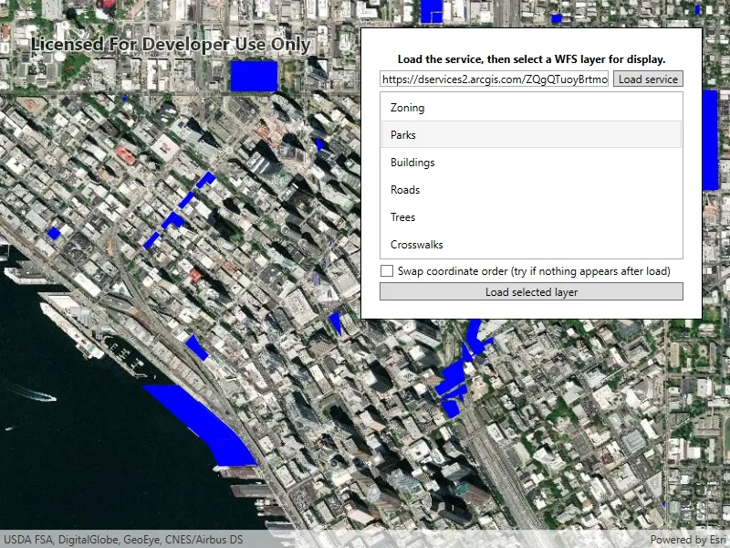
Browse a WFS service for layers and add them to the map.
Use case
Services often have multiple layers available for display. For example, a feature service for a city might have layers representing roads, land masses, building footprints, parks, and facilities. A user can choose to only show the road network and parks for a park accessibility analysis.
How to use the sample
A list of layers in the WFS service will be shown. Select a layer to display.
Some WFS services return coordinates in X,Y order, while others return coordinates in lat/long (Y,X) order. If you don’t see features rendered or you see features in the wrong location, use the checkbox to change the coordinate order and reload.
How it works
- Create a
WfsServiceobject with a URL to a WFS feature service. - Obtain a list of
WfsLayerInfofromWfsService.ServiceInfo. - When a layer is selected, create a
WfsFeatureTablefrom theWfsLayerInfo.- Set the axis order if necessary.
- Create a feature layer from the feature table.
- Add the feature layer to the map.
Relevant API
- FeatureLayer
- WfsFeatureTable
- WfsFeatureTable.AxisOrder
- WfsLayerInfo
- WfsService
- WfsServiceInfo
About the data
The sample is configured with a sample WFS service, but you can load other WFS services if desired. The default service shows Seattle downtown features hosted on ArcGIS Online.
Tags
browse, catalog, feature, layers, OGC, service, web, WFS
Sample code
// Copyright 2019 Esri.//// Licensed under the Apache License, Version 2.0 (the "License"); you may not use this file except in compliance with the License.// You may obtain a copy of the License at: http://www.apache.org/licenses/LICENSE-2.0//// Unless required by applicable law or agreed to in writing, software distributed under the License is distributed on an// "AS IS" BASIS, WITHOUT WARRANTIES OR CONDITIONS OF ANY KIND, either express or implied. See the License for the specific// language governing permissions and limitations under the License.
using Esri.ArcGISRuntime.Data;using Esri.ArcGISRuntime.Geometry;using Esri.ArcGISRuntime.Mapping;using Esri.ArcGISRuntime.Ogc;using Esri.ArcGISRuntime.Symbology;using System;using System.Collections.Generic;using System.Diagnostics;using System.Drawing;using System.Linq;using System.Threading.Tasks;using System.Windows;
namespace ArcGIS.WPF.Samples.BrowseWfsLayers{    [ArcGIS.Samples.Shared.Attributes.Sample(        name: "Browse WFS layers",        category: "Layers",        description: "Browse a WFS service for layers and add them to the map.",        instructions: "A list of layers in the WFS service will be shown. Select a layer to display.",        tags: new[] { "OGC", "WFS", "browse", "catalog", "feature", "layers", "service", "web" })]    public partial class BrowseWfsLayers    {        // URL to the WFS service.        private const string ServiceUrl = "https://dservices2.arcgis.com/ZQgQTuoyBrtmoGdP/arcgis/services/Seattle_Downtown_Features/WFSServer?service=wfs&request=getcapabilities";
        public BrowseWfsLayers()        {            InitializeComponent();            Initialize();        }
        private void Initialize()        {            // Update the UI.            ServiceTextBox.Text = ServiceUrl;
            // Create the map with imagery basemap.            MyMapView.Map = new Map(BasemapStyle.ArcGISImageryStandard);
            _ = LoadService();        }
        private async Task LoadService()        {            try            {                LoadingProgressBar.Visibility = Visibility.Visible;                LoadLayersButton.IsEnabled = false;                LoadServiceButton.IsEnabled = false;
                // Create the WFS service.                WfsService service = new WfsService(new Uri(ServiceTextBox.Text));
                // Load the WFS service.                await service.LoadAsync();
                // Get the service metadata.                WfsServiceInfo serviceInfo = service.ServiceInfo;
                // Get a reversed list of available layers.                IEnumerable<WfsLayerInfo> layerListReversed = serviceInfo.LayerInfos.Reverse();
                // Show the layers in the UI.                WfsLayerList.ItemsSource = layerListReversed;            }            catch (Exception ex)            {                Debug.WriteLine(ex);                MessageBox.Show(ex.Message, "Error loading service");            }            finally            {                // Update the UI.                LoadingProgressBar.Visibility = Visibility.Collapsed;                LoadLayersButton.IsEnabled = true;                LoadServiceButton.IsEnabled = true;            }        }
        private async void LoadLayers_Clicked(object sender, RoutedEventArgs e)        {            // Skip if nothing selected.            if (WfsLayerList.SelectedItems.Count < 1)            {                return;            }
            // Show the progress bar.            LoadingProgressBar.Visibility = Visibility.Visible;
            // Clear the existing layers.            MyMapView.Map.OperationalLayers.Clear();
            try            {                // Get the selected WFS layer.                WfsLayerInfo selectedLayerInfo = (WfsLayerInfo)WfsLayerList.SelectedItems[0];
                // Create the WFS feature table.                WfsFeatureTable table = new WfsFeatureTable(selectedLayerInfo);
                // Set the feature request mode to manual - only manual is supported at v100.5.                // In this mode, you must manually populate the table - panning and zooming won't request features automatically.                table.FeatureRequestMode = FeatureRequestMode.ManualCache;
                // Set the axis order based on the UI.                if (AxisOrderSwapCheckbox.IsChecked == true)                {                    table.AxisOrder = OgcAxisOrder.Swap;                }                else                {                    table.AxisOrder = OgcAxisOrder.NoSwap;                }
                // Populate the WFS table.                await table.PopulateFromServiceAsync(new QueryParameters(), false, null);
                // Create a feature layer from the WFS table.                FeatureLayer wfsFeatureLayer = new FeatureLayer(table);
                // Choose a renderer for the layer based on the table.                wfsFeatureLayer.Renderer = GetRendererForTable(table) ?? wfsFeatureLayer.Renderer;
                // Add the layer to the map.                MyMapView.Map.OperationalLayers.Add(wfsFeatureLayer);
                // Zoom to the extent of the selected layer.                await MyMapView.SetViewpointGeometryAsync(selectedLayerInfo.Extent, 50);            }            catch (Exception ex)            {                Debug.WriteLine(ex);                MessageBox.Show(ex.Message, "Error loading service");            }            finally            {                // Hide the progress bar.                LoadingProgressBar.Visibility = Visibility.Collapsed;            }        }
        private Renderer GetRendererForTable(FeatureTable table)        {            switch (table.GeometryType)            {                case GeometryType.Point:                case GeometryType.Multipoint:                    return new SimpleRenderer(new SimpleMarkerSymbol(SimpleMarkerSymbolStyle.Circle, Color.Blue, 4));
                case GeometryType.Polygon:                case GeometryType.Envelope:                    return new SimpleRenderer(new SimpleFillSymbol(SimpleFillSymbolStyle.Solid, Color.Blue, null));
                case GeometryType.Polyline:                    return new SimpleRenderer(new SimpleLineSymbol(SimpleLineSymbolStyle.Solid, Color.Blue, 1));            }
            return null;        }
private void LoadServiceButton_Click(object sender, RoutedEventArgs e) { _ = LoadService(); } }}<UserControl x:Class="ArcGIS.WPF.Samples.BrowseWfsLayers.BrowseWfsLayers" xmlns="http://schemas.microsoft.com/winfx/2006/xaml/presentation" xmlns:x="http://schemas.microsoft.com/winfx/2006/xaml" xmlns:esri="http://schemas.esri.com/arcgis/runtime/2013"> <Grid> <esri:MapView x:Name="MyMapView" /> <Border Style="{StaticResource BorderStyle}"> <Grid> <Grid.RowDefinitions> <RowDefinition Height="Auto" /> <RowDefinition Height="Auto" /> <RowDefinition Height="Auto" /> <RowDefinition Height="*" /> <RowDefinition Height="Auto" /> <RowDefinition Height="Auto" /> </Grid.RowDefinitions> <Grid.ColumnDefinitions> <ColumnDefinition Width="*" /> <ColumnDefinition Width="Auto" /> </Grid.ColumnDefinitions> <TextBlock Grid.Row="0" Grid.ColumnSpan="2" Margin="5" FontWeight="Bold" Foreground="Black" Text="Load the service, then select a WFS layer for display." TextAlignment="Center" /> <TextBox x:Name="ServiceTextBox" Grid.Row="1" Grid.Column="0" Margin="0,0,5,5" /> <Button x:Name="LoadServiceButton" Grid.Row="1" Grid.Column="1" Margin="0,0,0,5" Padding="5,0,5,0" Click="LoadServiceButton_Click" Content="Load service" /> <ProgressBar x:Name="LoadingProgressBar" Grid.Row="2" Grid.ColumnSpan="2" Height="15" Margin="0,5,0,5" IsEnabled="True" IsIndeterminate="True" Visibility="Visible" /> <ListView x:Name="WfsLayerList" Grid.Row="3" Grid.ColumnSpan="2" SelectionMode="Single"> <ListView.ItemTemplate> <DataTemplate> <Label Content="{Binding Title}" /> </DataTemplate> </ListView.ItemTemplate> </ListView> <CheckBox x:Name="AxisOrderSwapCheckbox" Grid.Row="4" Grid.ColumnSpan="2" Margin="0,5,0,5" Content="Swap coordinate order (try if nothing appears after load)" /> <Button x:Name="LoadLayersButton" Grid.Row="5" Grid.ColumnSpan="2" Click="LoadLayers_Clicked" Content="Load selected layer" /> </Grid> </Border> </Grid></UserControl>