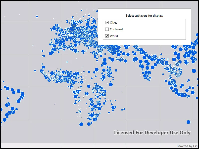
Change the visibility of sublayers.
Use case
A map image layer may contain many sublayers such as different types of roads in a road network or city, county, and state borders in a US map. The user may only be interested in a subset of these sublayers. Or, perhaps showing all of the sublayers would show too much detail. In these cases, you can hide certain sublayers by changing their visibility.
How to use the sample
Each sublayer has a check box which can be used to toggle the visibility of the sublayer.
How it works
- Create an
ArcGISMapImageLayerobject with the URL to a map image service. - Get the list of sublayers with
mapImageLayer.Sublayers. - For each layer in the sublayer list, set its visible property to true or false.
Relevant API
- ArcGISMapImageLayer
Tags
layers, sublayers, visibility
Sample code
// Copyright 2016 Esri.//// Licensed under the Apache License, Version 2.0 (the "License"); you may not use this file except in compliance with the License.// You may obtain a copy of the License at: http://www.apache.org/licenses/LICENSE-2.0//// Unless required by applicable law or agreed to in writing, software distributed under the License is distributed on an// "AS IS" BASIS, WITHOUT WARRANTIES OR CONDITIONS OF ANY KIND, either express or implied. See the License for the specific// language governing permissions and limitations under the License.
using Esri.ArcGISRuntime.Mapping;using System;using System.Threading.Tasks;using System.Windows;
namespace ArcGIS.WPF.Samples.ChangeSublayerVisibility{    [ArcGIS.Samples.Shared.Attributes.Sample(        name: "Map image layer sublayer visibility",        category: "Layers",        description: "Change the visibility of sublayers.",        instructions: "Each sublayer has a check box which can be used to toggle the visibility of the sublayer.",        tags: new[] { "layers", "sublayers", "visibility" })]    public partial class ChangeSublayerVisibility    {        public ChangeSublayerVisibility()        {            InitializeComponent();
            // Setup the control references and execute initialization            _ = Initialize();        }
        private async Task Initialize()        {            // Create new Map            Map myMap = new Map();
            // Create uri to the map image layer            Uri serviceUri = new Uri(               "https://sampleserver6.arcgisonline.com/arcgis/rest/services/SampleWorldCities/MapServer");
            // Create new image layer from the url            ArcGISMapImageLayer imageLayer = new ArcGISMapImageLayer(serviceUri)            {                Name = "World Cities Population"            };
            // Add created layer to the basemaps collection            myMap.Basemap.BaseLayers.Add(imageLayer);
            // Assign the map to the MapView            MyMapView.Map = myMap;
            try            {                // Wait that the image layer is loaded and sublayer information is fetched                await imageLayer.LoadAsync();
// Assign sublayers to the listview SublayerListView.ItemsSource = imageLayer.Sublayers; } catch (Exception e) { MessageBox.Show(e.ToString(), "Error"); } } }}<UserControl x:Class="ArcGIS.WPF.Samples.ChangeSublayerVisibility.ChangeSublayerVisibility" xmlns="http://schemas.microsoft.com/winfx/2006/xaml/presentation" xmlns:x="http://schemas.microsoft.com/winfx/2006/xaml" xmlns:esri="http://schemas.esri.com/arcgis/runtime/2013"> <Grid> <esri:MapView x:Name="MyMapView" /> <Border Style="{StaticResource BorderStyle}"> <StackPanel> <TextBlock Margin="0,0,0,5" FontWeight="SemiBold" Text="Select sublayers for display." TextAlignment="Center" TextWrapping="Wrap" /> <ListView x:Name="SublayerListView"> <ListView.ItemTemplate> <DataTemplate DataType="esri:ArcGISSublayer"> <CheckBox Margin="5" Content="{Binding Name}" IsChecked="{Binding IsVisible}" /> </DataTemplate> </ListView.ItemTemplate> </ListView> </StackPanel> </Border> </Grid></UserControl>