Filter features displayed on a map using a definition expression or a display filter.
Use case
Definition queries allow you to define a subset of features to work with in a layer by filtering which features are retrieved from the dataset by the layer. This means that a definition query affects not only drawing, but also which features appear in the layer’s attribute table and therefore which features can be selected, labeled, identified, and processed by geoprocessing tools.
Alternatively, display filters limit which features are drawn, but retain all features in queries and when processing. Definition queries and display filters can be used together on a layer, but definition queries limit the features available in the layer, while display filters only limit which features are displayed.
In this sample you can filter a dataset of tree quality selecting for only those trees which require maintenance or are damaged.
How to use the sample
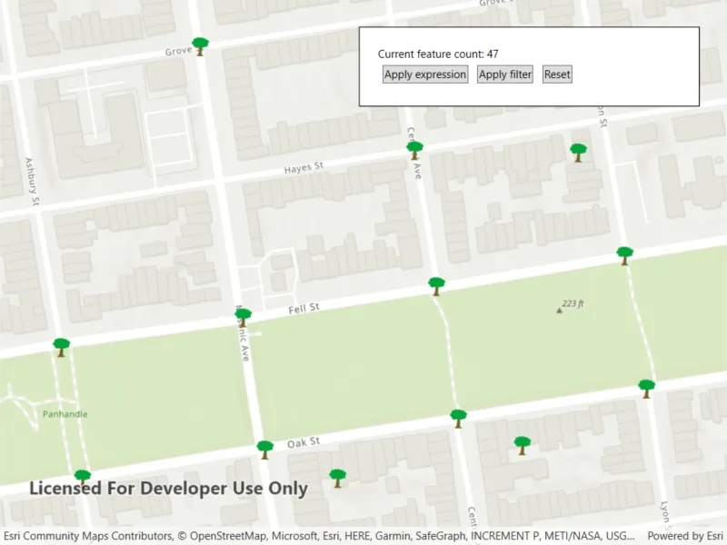
Use a definition expression to limit the features requested from the feature layer to those specified by a SQL query. This narrows down the results that are drawn, and removes those features from the layer’s attribute table. To filter the results being drawn without modifying the attribute table, hit the button to apply the display filter instead.
The feature count value shows the current number of features in the current map view extent. When a definition expression is applied to narrow down the list of features being drawn, the count is updated to reflect this change. However if a display filter is applied, the features which are not visible on the map will still be included in the total feature count.
How it works
- Create a service feature table from a URL.
- Create a feature layer from the service feature table.
- Filter features on your feature layer using a
DefinitionExpressionto view a subset of features and modify the attribute table. - Filter features on your feature layer using a
DisplayFilterto view a subset of features without modifying the attribute table.
Relevant API
- DefinitionExpression
- FeatureLayer
- ServiceFeatureTable
About the data
The San Francisco 311 incidents layer in this sample displays point features related to crime incidents such as grafitti and tree damage that have been reported by city residents.
Tags
definition expression, display filter, filter, limit data, query, restrict data, SQL, where clause
Sample code
// Copyright 2021 Esri.//// Licensed under the Apache License, Version 2.0 (the "License"); you may not use this file except in compliance with the License.// You may obtain a copy of the License at: http://www.apache.org/licenses/LICENSE-2.0//// Unless required by applicable law or agreed to in writing, software distributed under the License is distributed on an// "AS IS" BASIS, WITHOUT WARRANTIES OR CONDITIONS OF ANY KIND, either express or implied. See the License for the specific// language governing permissions and limitations under the License.
using Esri.ArcGISRuntime.Data;using Esri.ArcGISRuntime.Geometry;using Esri.ArcGISRuntime.Mapping;using Esri.ArcGISRuntime.UI;using System;using System.Threading.Tasks;using System.Windows;
namespace ArcGIS.WPF.Samples.FeatureLayerDefinitionExpression{    [ArcGIS.Samples.Shared.Attributes.Sample(        name: "Filter by definition expression or display filter",        category: "Layers",        description: "Filter features displayed on a map using a definition expression or a display filter.",        instructions: "Use a definition expression to limit the features requested from the feature layer to those specified by a SQL query. This narrows down the results that are drawn, and removes those features from the layer's attribute table. To filter the results being drawn without modifying the attribute table, hit the button to apply the display filter instead.",        tags: new[] { "SQL", "definition expression", "display filter", "filter", "limit data", "query", "restrict data", "where clause" })]    public partial class FeatureLayerDefinitionExpression    {        private const string FeatureServerURL = "https://services2.arcgis.com/ZQgQTuoyBrtmoGdP/arcgis/rest/services/SF_311_Incidents/FeatureServer/0";
        private readonly Viewpoint InitialViewpoint = new Viewpoint(new MapPoint(-122.44014487516885, 37.772296660953138, SpatialReferences.Wgs84), 3350);
        private ManualDisplayFilterDefinition _definition;
        private FeatureLayer _featureLayer;
        public FeatureLayerDefinitionExpression()        {            InitializeComponent();            Initialize();        }
        private void Initialize()        {            // Create the map.            MyMapView.Map = new Map(BasemapStyle.ArcGISTopographic) { InitialViewpoint = InitialViewpoint };
            // Add a feature layer to the map.            ServiceFeatureTable table = new ServiceFeatureTable(new Uri(FeatureServerURL));            _featureLayer = new FeatureLayer(table);            MyMapView.Map.OperationalLayers.Add(_featureLayer);
            // Create a display filter and display filter definition.            // req_type here is one of the published fields            DisplayFilter damagedTrees = new DisplayFilter(name: $"Damaged Trees", whereClause: "req_type LIKE '%Tree Maintenance%'");            _definition = new ManualDisplayFilterDefinition(activeFilter: damagedTrees, availableFilters: new[] { damagedTrees });        }
        private void Expression_Click(object sender, RoutedEventArgs e)        {            // Reset the display filter definition.            _featureLayer.DisplayFilterDefinition = null;
            // Set the definition expression to show specific features only.            _featureLayer.DefinitionExpression = "req_Type = 'Tree Maintenance or Damage'";        }
        private void Filter_Click(object sender, RoutedEventArgs e)        {            // Set the display filter definition on the layer.            _featureLayer.DisplayFilterDefinition = _definition;
            // Disable the feature layer definition expression            _featureLayer.DefinitionExpression = string.Empty;        }
        private void Reset_Click(object sender, RoutedEventArgs e)        {            // Reset the display filter definition.            _featureLayer.DisplayFilterDefinition = null;
            // Disable the feature layer definition expression            _featureLayer.DefinitionExpression = string.Empty;        }
        private void MapDrawStatusChanged(object sender, DrawStatusChangedEventArgs e)        {            _ = CountFeatures();        }
        private async Task CountFeatures()        {            try            {                // Get the extent of the current viewpoint.                Envelope extent = MyMapView.GetCurrentViewpoint(ViewpointType.BoundingGeometry)?.TargetGeometry?.Extent;
                // Return if no valid extent.                if (extent == null) return;
// Update the UI with the count of features in the extent long totalIncidentReported = await _featureLayer.FeatureTable.QueryFeatureCountAsync(new QueryParameters() { Geometry = extent }); IncidentReportSummary.Text = $"Current feature count: {totalIncidentReported}"; } catch (Exception ex) { MessageBox.Show(ex.Message, ex.GetType().Name, MessageBoxButton.OK, MessageBoxImage.Error); } } }}<UserControl x:Class="ArcGIS.WPF.Samples.FeatureLayerDefinitionExpression.FeatureLayerDefinitionExpression" xmlns="http://schemas.microsoft.com/winfx/2006/xaml/presentation" xmlns:x="http://schemas.microsoft.com/winfx/2006/xaml" xmlns:esri="http://schemas.esri.com/arcgis/runtime/2013"> <Grid> <esri:MapView x:Name="MyMapView" DrawStatusChanged="MapDrawStatusChanged" /> <Border Style="{StaticResource BorderStyle}"> <StackPanel Orientation="Vertical"> <TextBlock x:Name="IncidentReportSummary" /> <StackPanel Orientation="Horizontal"> <Button Margin="5" Click="Expression_Click" Content="Apply expression" /> <Button Margin="5" Click="Filter_Click" Content="Apply filter" /> <Button Margin="5" Click="Reset_Click" Content="Reset" /> </StackPanel> </StackPanel> </Border> </Grid></UserControl>