Display local 3D point cloud data.
Use case
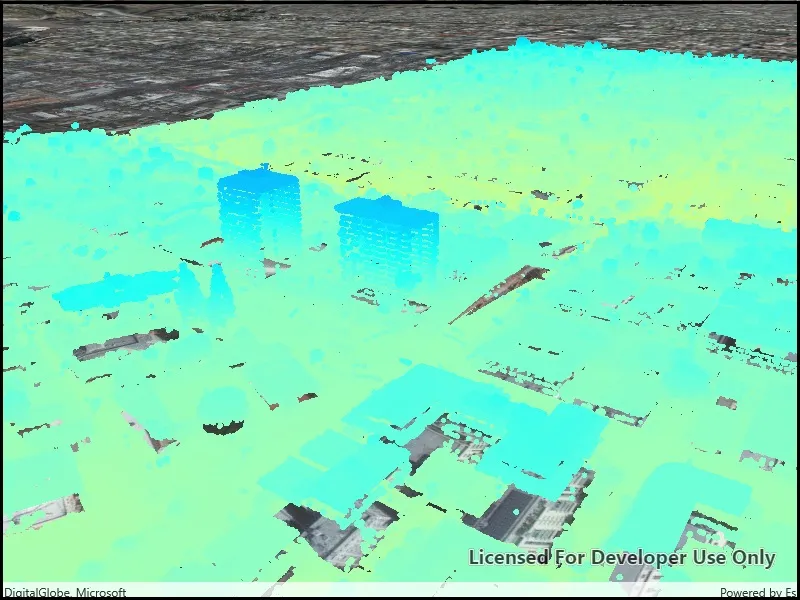
Point clouds are often used to visualize massive sets of sensor data such as lidar. The point locations indicate where the sensor data was measured spatially, and the color or size of the points indicate the measured/derived value of the sensor reading. In the case of lidar, the color of the visualized point could be the color of the reflected light, so that the point cloud forms a true color 3D image of the area.
Point clouds can be loaded offline from scene layer packages (.slpk).
How to use the sample
The sample starts with a point cloud layer loaded and draped on top of a scene. Pan and zoom to explore the scene and see the detail of the point cloud layer.
How it works
- Create a
PointCloudLayerwith the path to a local .slpk file containing a point cloud layer. - Add the layer to a scene’s operational layers collection.
Relevant API
- PointCloudLayer
About the data
This point cloud data comes from Balboa Park in San Diego, California. Created and provided by USGS.
Tags
3D, lidar, point cloud
Sample code
// Copyright 2019 Esri.//// Licensed under the Apache License, Version 2.0 (the "License"); you may not use this file except in compliance with the License.// You may obtain a copy of the License at: http://www.apache.org/licenses/LICENSE-2.0//// Unless required by applicable law or agreed to in writing, software distributed under the License is distributed on an// "AS IS" BASIS, WITHOUT WARRANTIES OR CONDITIONS OF ANY KIND, either express or implied. See the License for the specific// language governing permissions and limitations under the License.
using ArcGIS.Samples.Managers;using Esri.ArcGISRuntime.Mapping;using System;using System.Threading.Tasks;
namespace ArcGIS.WPF.Samples.ViewPointCloudDataOffline{    [ArcGIS.Samples.Shared.Attributes.Sample(        name: "View point cloud data offline",        category: "Data",        description: "Display local 3D point cloud data.",        instructions: "The sample starts with a point cloud layer loaded and draped on top of a scene. Pan and zoom to explore the scene and see the detail of the point cloud layer.",        tags: new[] { "3D", "lidar", "point cloud" })]    [ArcGIS.Samples.Shared.Attributes.OfflineData("34da965ca51d4c68aa9b3a38edb29e00")]    public partial class ViewPointCloudDataOffline    {        // Hold the URL to the elevation service.        private const string ElevationServiceUrl = "https://elevation3d.arcgis.com/arcgis/rest/services/WorldElevation3D/Terrain3D/ImageServer";
        public ViewPointCloudDataOffline()        {            InitializeComponent();            _ = Initialize();        }
        private async Task Initialize()        {            // Create the scene with basemap.            MySceneView.Scene = new Scene(BasemapStyle.ArcGISImageryStandard);
            // Create a surface and add the elevation service to it.            Surface groundSurface = new Surface();            groundSurface.ElevationSources.Add(new ArcGISTiledElevationSource(new Uri(ElevationServiceUrl)));
            // Add the surface to the scene.            MySceneView.Scene.BaseSurface = groundSurface;
            // Get the path to the local point cloud data.            string pointCloudPath = DataManager.GetDataFolder("34da965ca51d4c68aa9b3a38edb29e00", "sandiego-north-balboa-pointcloud.slpk");
            // Create the point cloud layer.            PointCloudLayer balboaPointCloud = new PointCloudLayer(new Uri(pointCloudPath));
            // Add the point cloud to the scene.            MySceneView.Scene.OperationalLayers.Add(balboaPointCloud);
            // Wait for the layer to load.            await balboaPointCloud.LoadAsync();
// Zoom to the extent of the point cloud. await MySceneView.SetViewpointAsync(new Viewpoint(balboaPointCloud.FullExtent)); } }}<UserControl x:Class="ArcGIS.WPF.Samples.ViewPointCloudDataOffline.ViewPointCloudDataOffline" xmlns="http://schemas.microsoft.com/winfx/2006/xaml/presentation" xmlns:x="http://schemas.microsoft.com/winfx/2006/xaml" xmlns:esri="http://schemas.esri.com/arcgis/runtime/2013"> <Grid> <esri:SceneView x:Name="MySceneView" /> </Grid></UserControl>