Display a shapefile with custom symbology.
Use case
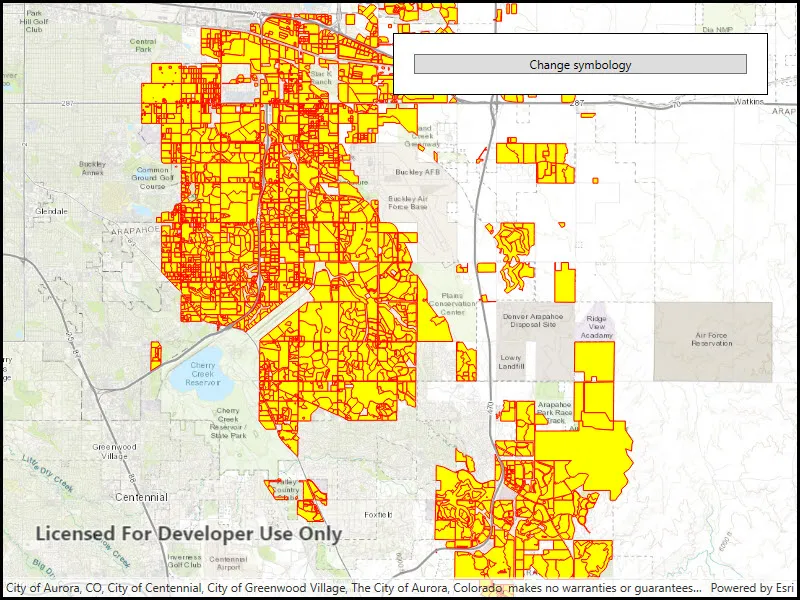
Feature layers created from shapefiles do not possess any rendering information, and will be assigned with a default symbology. You can apply custom styling to ensure that the content is visible and usable in the context of a specific map. For example, you could use this to visually differentiate between features originating from two different shapefiles, by applying a blue color to one, and a red color to the other.
How to use the sample
Click the button to apply a new symbology renderer to the feature layer created from the shapefile.
How it works
- Create a
ShapefileFeatureTable, providing the path to a shapefile. - Create a
FeatureLayerand associate it with theShapeFileFeatureTable. - Create a
SimpleRendererto override the default symbology. The simple renderer takes a symbol and applies that to all features in a layer. - Apply the renderer to the
FeatureLayerby setting the renderer.
Relevant API
- FeatureLayer
- ShapefileFeatureTable
- SimpleFillSymbol
- SimpleLineSymbol
- SimpleRenderer
Offline data
This sample downloads the following items from ArcGIS Online automatically:
- Aurora_CO_shp.zip - Shapefiles that cover Aurora Colorado: Public art (points), Bike trails (lines), and Subdivisions (polygons).
About the data
This sample displays a shapefile containing subdivisions in Aurora, CO.
Additional information
While shapefiles contain no rendering information, other data sources such as Service Feature Tables or Geodatabase Feature Tables can contain such information. As a result, the rendering properties of the other data sources can be pre-defined by the author.
Tags
package, shape file, shapefile, symbology, visualization
Sample code
// Copyright 2017 Esri.//// Licensed under the Apache License, Version 2.0 (the "License"); you may not use this file except in compliance with the License.// You may obtain a copy of the License at: http://www.apache.org/licenses/LICENSE-2.0//// Unless required by applicable law or agreed to in writing, software distributed under the License is distributed on an// "AS IS" BASIS, WITHOUT WARRANTIES OR CONDITIONS OF ANY KIND, either express or implied. See the License for the specific// language governing permissions and limitations under the License.
using ArcGIS.Samples.Managers;using Esri.ArcGISRuntime.Data;using Esri.ArcGISRuntime.Geometry;using Esri.ArcGISRuntime.Mapping;using Esri.ArcGISRuntime.Symbology;using System;using System.Drawing;using System.Threading.Tasks;using System.Windows;
namespace ArcGIS.WPF.Samples.SymbolizeShapefile{    [ArcGIS.Samples.Shared.Attributes.Sample(        name: "Symbolize shapefile",        category: "Data",        description: "Display a shapefile with custom symbology.",        instructions: "Click the button to apply a new symbology renderer to the feature layer created from the shapefile. ",        tags: new[] { "package", "shape file", "shapefile", "symbology", "visualization" })]    [ArcGIS.Samples.Shared.Attributes.OfflineData("d98b3e5293834c5f852f13c569930caa")]    public partial class SymbolizeShapefile    {        // Hold reference to the feature layer so that its renderer can be changed when button is pushed        private FeatureLayer _shapefileFeatureLayer;
        // Hold reference to default renderer to enable switching back        private Renderer _defaultRenderer;
        // Hold reference to alternate renderer to enable switching        private SimpleRenderer _alternateRenderer;
        public SymbolizeShapefile()        {            InitializeComponent();
            // Create the UI, setup the control references and execute initialization            _ = Initialize();        }
        private async Task Initialize()        {            // Create the map with topographic basemap            Map myMap = new Map(BasemapStyle.ArcGISTopographic);
            // Create the point for the map's initial viewpoint            MapPoint point = new MapPoint(-11662054, 4818336, SpatialReference.Create(3857));
            // Create a viewpoint for the point            Viewpoint viewpoint = new Viewpoint(point, 200000);
            // Set the initial viewpoint            myMap.InitialViewpoint = viewpoint;
            // Create a shapefile feature table from the shapefile path            ShapefileFeatureTable myFeatureTable = new ShapefileFeatureTable(GetShapefilePath());
            // Create a layer from the feature table            _shapefileFeatureLayer = new FeatureLayer(myFeatureTable);
            // Add the layer to the map            myMap.OperationalLayers.Add(_shapefileFeatureLayer);
            // Create the symbology for the alternate renderer            SimpleLineSymbol lineSymbol = new SimpleLineSymbol(SimpleLineSymbolStyle.Solid, Color.Red, 1.0);            SimpleFillSymbol fillSymbol = new SimpleFillSymbol(SimpleFillSymbolStyle.Solid, Color.Yellow, lineSymbol);
            // Create the alternate renderer            _alternateRenderer = new SimpleRenderer(fillSymbol);
            try            {                // Wait for the layer to load so that it will be assigned a default renderer                await _shapefileFeatureLayer.LoadAsync();
                // Hold a reference to the default renderer (to enable switching between the renderers)                _defaultRenderer = _shapefileFeatureLayer.Renderer;
                // Add the map to the mapview                MyMapView.Map = myMap;
                // Enable changing symbology now that sample is loaded                MyRendererButton.IsEnabled = true;            }            catch (Exception e)            {                MessageBox.Show(e.ToString(), "Error");            }        }
        private void Button_Click(object sender, RoutedEventArgs e)        {            // Toggle the renderer            if (_shapefileFeatureLayer.Renderer == _defaultRenderer)            {                _shapefileFeatureLayer.Renderer = _alternateRenderer;            }            else            {                _shapefileFeatureLayer.Renderer = _defaultRenderer;            }        }
private static string GetShapefilePath() { return DataManager.GetDataFolder("d98b3e5293834c5f852f13c569930caa", "Subdivisions.shp"); } }}<UserControl x:Class="ArcGIS.WPF.Samples.SymbolizeShapefile.SymbolizeShapefile" xmlns="http://schemas.microsoft.com/winfx/2006/xaml/presentation" xmlns:x="http://schemas.microsoft.com/winfx/2006/xaml" xmlns:esri="http://schemas.esri.com/arcgis/runtime/2013"> <Grid> <esri:MapView x:Name="MyMapView" /> <Border Style="{StaticResource BorderStyle}"> <Button x:Name="MyRendererButton" Click="Button_Click" Content="Change symbology" IsEnabled="False" /> </Border> </Grid></UserControl>