Apply mosaic rule to a mosaic dataset of rasters.
Use case
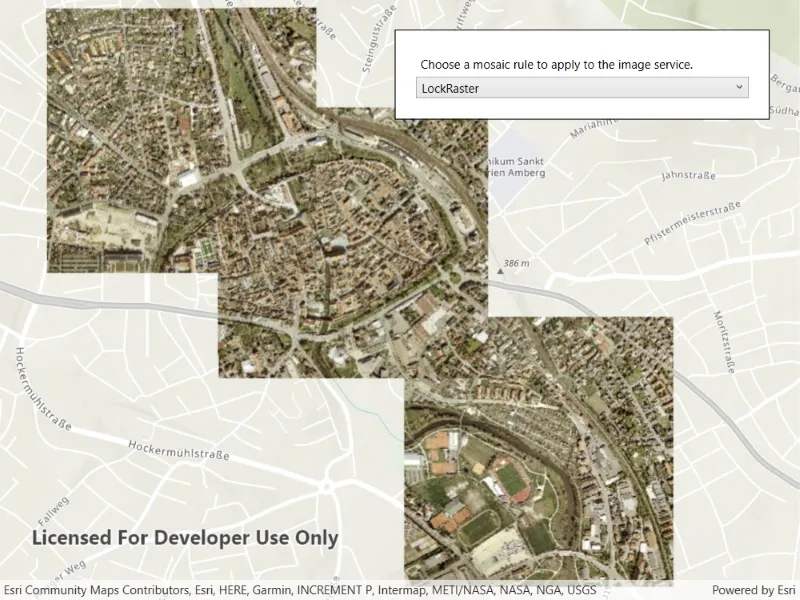
An image service can use a mosaic rule to mosaic multiple rasters on-the-fly. A mosaic rule can specify which rasters are selected, and how the selected rasters are z-ordered. It can also specify how overlapping pixels from different rasters at the same location are resolved.
For example, when using the “ByAttribute” mosaic method, the values in an attribute field are used to sort the images, and when using the “Center” method, the image closest to the center of the display is positioned as the top image in the mosaic. Additionally, the mosaic operator allows you to define how to resolve the overlapping cells, such as choosing a blending operation.
Specifying mosaic rules is useful for viewing overlapping rasters. For example, using the “ByAttribute” mosaic method to sort the rasters based on their acquisition date allows the newest image to be on top. Using “Mean” mosaic operation makes the overlapping areas contain the mean cell values from all the overlapping rasters.
How to use the sample
When the rasters are loaded, choose from a list of preset mosaic rules to apply to the rasters.
How it works
- Create an
ImageServiceRasterusing the service’s URL. - Create a
MosaicRuleobject and set it to theMosaicRuleproperty of the image service raster, if it does not specify a mosaic rule. - Create a
RasterLayerfrom the image service raster and add it to the map. - Set the
MosaicMethod,MosaicOperation, and other properties of the mosaic rule object accordingly to specify the rule on the raster dataset.
Relevant API
- ImageServiceRaster
- MosaicMethod
- MosaicOperation
- MosaicRule
About the data
This sample uses a raster image service hosted on ArcGIS Online that shows aerial images of Amberg, Germany.
Additional information
For more information, see Mosaicking rules for a mosaic dataset from the ArcGIS Pro documentation. To learn more about how to define certain mosaic rules, see Mosaic rule objects from ArcGIS for Developers.
Tags
image service, mosaic method, mosaic rule, raster
Sample code
// Copyright 2021 Esri.//// Licensed under the Apache License, Version 2.0 (the "License"); you may not use this file except in compliance with the License.// You may obtain a copy of the License at: http://www.apache.org/licenses/LICENSE-2.0//// Unless required by applicable law or agreed to in writing, software distributed under the License is distributed on an// "AS IS" BASIS, WITHOUT WARRANTIES OR CONDITIONS OF ANY KIND, either express or implied. See the License for the specific// language governing permissions and limitations under the License.
using Esri.ArcGISRuntime.Mapping;using Esri.ArcGISRuntime.Rasters;using System;using System.Collections.Generic;using System.Threading.Tasks;
namespace ArcGIS.WPF.Samples.ApplyMosaicRule{    [ArcGIS.Samples.Shared.Attributes.Sample(        name: "Apply mosaic rule to rasters",        category: "Layers",        description: "Apply mosaic rule to a mosaic dataset of rasters.",        instructions: "When the rasters are loaded, choose from a list of preset mosaic rules to apply to the rasters.",        tags: new[] { "image service", "mosaic method", "mosaic rule", "raster" })]    public partial class ApplyMosaicRule    {        private ImageServiceRaster _imageServiceRaster;
        // Different mosaic rules to use with the image service raster.        private Dictionary<string, MosaicRule> _mosaicRules = new Dictionary<string, MosaicRule>        {            { "None", new MosaicRule { MosaicMethod = MosaicMethod.None} },            { "Northwest", new MosaicRule { MosaicMethod = MosaicMethod.Northwest, MosaicOperation = MosaicOperation.First} },            { "Center", new MosaicRule { MosaicMethod = MosaicMethod.Center, MosaicOperation = MosaicOperation.Blend} },            { "ByAttribute", new MosaicRule { MosaicMethod = MosaicMethod.Attribute, SortField = "OBJECTID"} },            { "LockRaster", new MosaicRule { MosaicMethod = MosaicMethod.LockRaster, LockRasterIds = { 1, 7, 12 } } },        };
        public ApplyMosaicRule()        {            InitializeComponent();            _ = Initialize();        }
        private async Task Initialize()        {            // Create a raster layer using an image service.            _imageServiceRaster = new ImageServiceRaster(new Uri("https://sampleserver7.arcgisonline.com/server/rest/services/amberg_germany/ImageServer"));            RasterLayer rasterLayer = new RasterLayer(_imageServiceRaster);            await rasterLayer.LoadAsync();
            // Create a map with the raster layer.            MyMapView.Map = new Map(BasemapStyle.ArcGISTopographic);            MyMapView.Map.OperationalLayers.Add(rasterLayer);            await MyMapView.SetViewpointAsync(new Viewpoint(rasterLayer.FullExtent));
            // Populate the combo box.            MosaicRulesBox.ItemsSource = _mosaicRules.Keys;            MosaicRulesBox.SelectedIndex = 0;        }
private void MosaicRulesBox_SelectionChanged(object sender, System.Windows.Controls.SelectionChangedEventArgs e) { // Change the mosaic rule used for the image service raster. _imageServiceRaster.MosaicRule = _mosaicRules[MosaicRulesBox.SelectedItem as string]; } }}<UserControl x:Class="ArcGIS.WPF.Samples.ApplyMosaicRule.ApplyMosaicRule" xmlns="http://schemas.microsoft.com/winfx/2006/xaml/presentation" xmlns:x="http://schemas.microsoft.com/winfx/2006/xaml" xmlns:esri="http://schemas.esri.com/arcgis/runtime/2013"> <Grid> <esri:MapView x:Name="MyMapView" /> <Border HorizontalAlignment="Right" VerticalAlignment="Top" Style="{StaticResource BorderStyle}"> <StackPanel> <Label Content="Choose a mosaic rule to apply to the image service." /> <ComboBox x:Name="MosaicRulesBox" SelectionChanged="MosaicRulesBox_SelectionChanged" /> </StackPanel> </Border> </Grid></UserControl>