Edit feature attributes which are linked to annotation through an expression.
Use case
Annotation is useful for displaying text that you don’t want to move or resize when the map is panned or zoomed (unlike labels which will move and resize). Feature-linked annotation will update when a feature attribute referenced by the annotation expression is also updated. Additionally, the position of the annotation will transform to match any transformation to the linked feature’s geometry.
How to use the sample
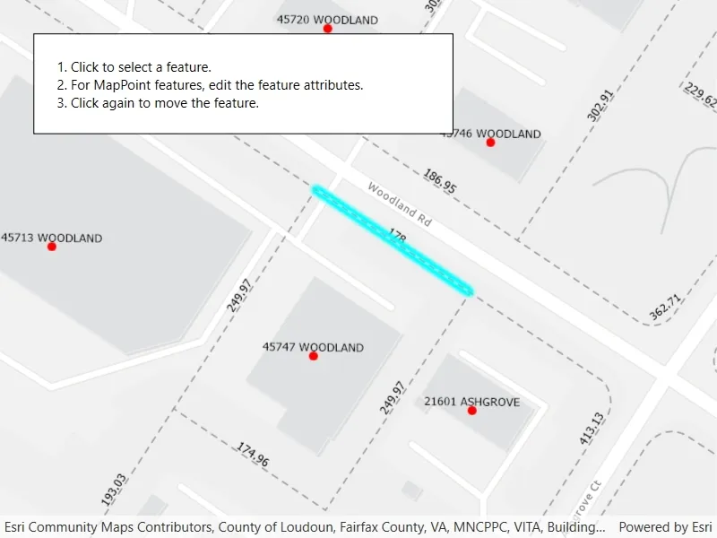
Pan and zoom the map to see that the text on the map is annotation, not labels. Click one of the address points to update the house number (AD_ADDRESS) and street name (ST_STR_NAM). Click one of the dashed parcel polylines and click another location to change its geometry. NOTE: Selection is only enabled for points and straight (single segment) polylines.
The feature-linked annotation will update accordingly.
How it works
- Load the geodatabase. NOTE: Read/write geodatabases should normally come from a
GeodatabaseSyncTask, but this has been omitted here. That functionality is covered in the sample Generate geodatabase. - Create
FeatureLayers from geodatabase feature tables found in the geodatabase withgeodatabase.GeodatabaseFeatureTable. - Create
AnnotationLayers from geodatabase feature tables found in the geodatabase withgeodatabase.GeodatabaseAnnotationTable. - Add the
FeatureLayers andAnnotationLayers to the map’s operational layers. - Use a
GeoViewTappedevent handler to listen for clicks on the map to either select address points or parcel polyline features. NOTE: Selection is only enabled for points and straight (single segment) polylines.- For the address points, a dialog is opened to allow editing of the address number (AD_ADDRESS) and street name (ST_STR_NAM) attributes.
- For the parcel lines, a second tap will change one of the polyline’s vertices.
Both expressions were defined by the data author in ArcGIS Pro using the Arcade expression language.
Relevant API
- AnnotationLayer
- Feature
- FeatureLayer
- Geodatabase
Offline data
This sample downloads the following items from ArcGIS Online automatically:
About the data
This sample uses data derived from the Loudoun GeoHub.
The annotation linked to the point data in this sample is defined by arcade expression $feature.AD_ADDRESS + " " + $feature.ST_STR_NAM. The annotation linked to the parcel polyline data is defined by Round(Length(Geometry($feature), 'feet'), 2).
Tags
annotation, attributes, feature-linked annotation, features, fields
Sample code
// Copyright 2021 Esri.//// Licensed under the Apache License, Version 2.0 (the "License"); you may not use this file except in compliance with the License.// You may obtain a copy of the License at: http://www.apache.org/licenses/LICENSE-2.0//// Unless required by applicable law or agreed to in writing, software distributed under the License is distributed on an// "AS IS" BASIS, WITHOUT WARRANTIES OR CONDITIONS OF ANY KIND, either express or implied. See the License for the specific// language governing permissions and limitations under the License.
using ArcGIS.Samples.Managers;using Esri.ArcGISRuntime.Data;using Esri.ArcGISRuntime.Geometry;using Esri.ArcGISRuntime.Mapping;using Esri.ArcGISRuntime.UI.Controls;using System;using System.Collections.Generic;using System.Linq;using System.Threading.Tasks;using System.Windows;
namespace ArcGIS.WPF.Samples.EditFeatureLinkedAnnotation{    [ArcGIS.Samples.Shared.Attributes.Sample(        name: "Edit features with feature-linked annotation",        category: "Data",        description: "Edit feature attributes which are linked to annotation through an expression.",        instructions: "Pan and zoom the map to see that the text on the map is annotation, not labels. Click one of the address points to update the house number (AD_ADDRESS) and street name (ST_STR_NAM). Click one of the dashed parcel polylines and click another location to change its geometry. NOTE: Selection is only enabled for points and straight (single segment) polylines.",        tags: new[] { "annotation", "attributes", "feature-linked annotation", "features", "fields" })]    [ArcGIS.Samples.Shared.Attributes.OfflineData("74c0c9fa80f4498c9739cc42531e9948")]    public partial class EditFeatureLinkedAnnotation    {        private Feature _selectedFeature;
        public EditFeatureLinkedAnnotation()        {            InitializeComponent();            _ = Initialize();        }
        private async Task Initialize()        {            // NOTE: to be a writable geodatabase, this geodatabase must be generated from a service with a GeodatabaseSyncTask. See the "Generate geodatabase" sample.            try            {                // Create and load geodatabase.                string geodatabasePath = DataManager.GetDataFolder("74c0c9fa80f4498c9739cc42531e9948", "loudoun_anno.geodatabase");                Geodatabase geodatabase = await Geodatabase.OpenAsync(geodatabasePath);
                // Create feature layers from tables in the geodatabase.                FeatureLayer addressFeatureLayer = new FeatureLayer(geodatabase.GetGeodatabaseFeatureTable("Loudoun_Address_Points_1"));                FeatureLayer parcelFeatureLayer = new FeatureLayer(geodatabase.GetGeodatabaseFeatureTable("ParcelLines_1"));
                // Create annotation layers from tables in the geodatabase.                AnnotationLayer addressAnnotationLayer = new AnnotationLayer(geodatabase.GetGeodatabaseAnnotationTable("Loudoun_Address_PointsAnno_1"));                AnnotationLayer parcelAnnotationLayer = new AnnotationLayer(geodatabase.GetGeodatabaseAnnotationTable("ParcelLinesAnno_1"));
                // Create a map with the layers.                MyMapView.Map = new Map(BasemapStyle.ArcGISLightGray);                MyMapView.Map.OperationalLayers.AddRange(new List<Layer> { addressFeatureLayer, parcelFeatureLayer, addressAnnotationLayer, parcelAnnotationLayer });
                // Zoom to the extent of the parcels.                await parcelFeatureLayer.LoadAsync();                MyMapView.SetViewpoint(new Viewpoint(parcelFeatureLayer.FullExtent));            }            catch (Exception ex)            {                MessageBox.Show(ex.Message, "Error");            }        }
        private void MyMapView_GeoViewTapped(object sender, GeoViewInputEventArgs e)        {            // Check if there is already a selected feature.            if (_selectedFeature == null)            {                _ = SelectFeature(e.Position);            }            else            {                // Project the user selected point.                MapPoint projPoint = e.Location.Project(_selectedFeature.Geometry.SpatialReference) as MapPoint;
                // Update the geometry of the selected feature.                _ = UpdateGeometry(projPoint);            }        }
        private async Task SelectFeature(Point clickedPoint)        {            try            {                // Identify across all layers.                IReadOnlyList<IdentifyLayerResult> identifyResults = await MyMapView.IdentifyLayersAsync(clickedPoint, 10.0, false);                foreach (IdentifyLayerResult result in identifyResults)                {                    if (result.LayerContent is FeatureLayer layer)                    {                        _selectedFeature = result.GeoElements.First() as Feature;                        if (_selectedFeature.Geometry is Polyline line)                        {                            // No support for curved lines.                            if (line.Parts.Count > 1)                            {                                _selectedFeature = null;                                return;                            }                        }                        else if (_selectedFeature.Geometry is MapPoint)                        {                            // Open attribute editor for point features.                            ShowEditableAttributes();                        }
                        // Select the feature.                        layer.SelectFeature(_selectedFeature);                        break;                    }                }            }            catch (Exception ex)            {                MessageBox.Show(ex.Message, "Error");            }        }
        private async Task UpdateGeometry(MapPoint point)        {            if (_selectedFeature.Geometry is Polyline line)            {                // Get the nearest point on the selected line.                ProximityResult nearestVertex = line.NearestVertex(point);
                // Create a new polyline.                PolylineBuilder polylineBuilder = new PolylineBuilder(line);                Part part = polylineBuilder.Parts[nearestVertex.PartIndex];
                // Replace the nearest point with the new point.                part.SetPoint(nearestVertex.PointIndex, point);
                // Update the geometry of the feature.                _selectedFeature.Geometry = GeometryEngine.Project(polylineBuilder.ToGeometry(), _selectedFeature.Geometry.SpatialReference);                await _selectedFeature.FeatureTable.UpdateFeatureAsync(_selectedFeature);            }            else if (_selectedFeature.Geometry is MapPoint)            {                // Update the geometry of the feature.                _selectedFeature.Geometry = point;                await _selectedFeature.FeatureTable.UpdateFeatureAsync(_selectedFeature);            }
            // Clear the selection.            (_selectedFeature.FeatureTable.Layer as FeatureLayer).ClearSelection();            _selectedFeature = null;        }
        private void ShowEditableAttributes()        {            // Show entry UI.            MyMapView.IsEnabled = false;            AttributesBorder.Visibility = Visibility.Visible;
            // Populate entry fields with data from feature.            AdressBox.Text = _selectedFeature.Attributes["AD_ADDRESS"].ToString();            StreetNameBox.Text = _selectedFeature.Attributes["ST_STR_NAM"].ToString();        }
        private void CancelClick(object sender, RoutedEventArgs e)        {            // Hide entry UI.            MyMapView.IsEnabled = true;            AttributesBorder.Visibility = Visibility.Collapsed;        }
private async void OkClick(object sender, RoutedEventArgs e) { try { // Update the feature attributes with the user input. _selectedFeature.Attributes["AD_ADDRESS"] = int.Parse(AdressBox.Text); _selectedFeature.Attributes["ST_STR_NAM"] = StreetNameBox.Text; await _selectedFeature.FeatureTable.UpdateFeatureAsync(_selectedFeature); } catch (Exception ex) { MessageBox.Show(ex.Message, "Error"); } finally { // Hide entry UI. MyMapView.IsEnabled = true; AttributesBorder.Visibility = Visibility.Collapsed; } } }}<UserControl x:Class="ArcGIS.WPF.Samples.EditFeatureLinkedAnnotation.EditFeatureLinkedAnnotation" xmlns="http://schemas.microsoft.com/winfx/2006/xaml/presentation" xmlns:x="http://schemas.microsoft.com/winfx/2006/xaml" xmlns:esri="http://schemas.esri.com/arcgis/runtime/2013"> <Grid> <esri:MapView x:Name="MyMapView" GeoViewTapped="MyMapView_GeoViewTapped" /> <Border HorizontalAlignment="Left" Style="{StaticResource BorderStyle}"> <TextBlock Text="1. Click to select a feature.
2. For MapPoint features, edit the feature attributes.
3. Click again to move the feature." /> </Border> <Border x:Name="AttributesBorder" Style="{StaticResource BorderStyle}" Visibility="Collapsed"> <Grid> <Grid.RowDefinitions> <RowDefinition Height="Auto" /> <RowDefinition Height="Auto" /> <RowDefinition Height="Auto" /> <RowDefinition Height="Auto" /> </Grid.RowDefinitions> <Grid.ColumnDefinitions> <ColumnDefinition Width="Auto" /> <ColumnDefinition /> </Grid.ColumnDefinitions> <Label Grid.Row="0" Grid.Column="0" Grid.ColumnSpan="2" Content="Edit feature attribute:" /> <Label Grid.Row="1" Grid.Column="0" Content="AD_ADDRESS" /> <TextBox x:Name="AdressBox" Grid.Row="1" Grid.Column="1" Margin="5" /> <Label Grid.Row="2" Grid.Column="0" Content="ST_STR_NAM" /> <TextBox x:Name="StreetNameBox" Grid.Row="2" Grid.Column="1" Margin="5" /> <Button Grid.Row="3" Grid.Column="0" Margin="5" HorizontalAlignment="Stretch" Click="CancelClick" Content="Cancel" /> <Button Grid.Row="3" Grid.Column="1" Margin="5" Click="OkClick" Content="OK" /> </Grid> </Border> </Grid></UserControl>