Find features in a sublayer based on attributes and location.
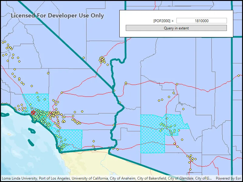
Use case
Sublayers of an ArcGISMapImageLayer may expose a ServiceFeatureTable through a table property. This allows you to perform the same queries available when working with a table from a FeatureLayer: attribute query, spatial query, statistics query, query for related features, etc. An image layer with a sublayer of counties can be queried by population to only show those above a minimum population.
How to use the sample
Specify a minimum population in the input field (values under 1810000 will produce a selection in all layers) and click the query button to query the sublayers in the current view extent. After a short time, the results for each sublayer will appear as graphics.
How it works
- Create an
ArcGISMapImageLayerobject using the URL of an image service. - After loading the layer, get the sublayer you want to query with
(ArcGISMapImageSublayer) layer.Sublayers[index]. - Load the sublayer, and then get its
ServiceFeatureTablewithsublayer.getTable(). - Create
QueryParameters. You can setqueryParameters.WhereClauseto query against a table attribute and/or setqueryParameters.Geometryto limit the results to an area of the map. - Call
sublayerTable.QueryFeaturesAsync(queryParameters)to get aFeatureQueryResultwith features matching the query. The result is an iterable of features.
Relevant API
- ArcGISMapImageLayer
- ArcGISMapImageSublayer
- QueryParameters
- ServiceFeatureTable
About the data
The ArcGISMapImageLayer in the map uses the “USA” map service as its data source. This service is hosted by ArcGIS Online, and is composed of four sublayers: “states”, “counties”, “cities”, and “highways”.
Since the cities, counties, and states tables all have a POP2000 field, they can all execute a query against that attribute and a map extent.
Tags
search and query
Sample code
// Copyright 2018 Esri.//// Licensed under the Apache License, Version 2.0 (the "License"); you may not use this file except in compliance with the License.// You may obtain a copy of the License at: http://www.apache.org/licenses/LICENSE-2.0//// Unless required by applicable law or agreed to in writing, software distributed under the License is distributed on an// "AS IS" BASIS, WITHOUT WARRANTIES OR CONDITIONS OF ANY KIND, either express or implied. See the License for the specific// language governing permissions and limitations under the License.
using Esri.ArcGISRuntime.Data;using Esri.ArcGISRuntime.Geometry;using Esri.ArcGISRuntime.Mapping;using Esri.ArcGISRuntime.Symbology;using Esri.ArcGISRuntime.UI;using System;using System.Drawing;using System.Windows;
namespace ArcGIS.WPF.Samples.MapImageSublayerQuery{    [ArcGIS.Samples.Shared.Attributes.Sample(        name: "Query map image sublayer",        category: "Layers",        description: "Find features in a sublayer based on attributes and location.",        instructions: "Specify a minimum population in the input field (values under 1810000 will produce a selection in all layers) and click the query button to query the sublayers in the current view extent. After a short time, the results for each sublayer will appear as graphics.",        tags: new[] { "search and query" })]    public partial class MapImageSublayerQuery    {        // Use a private variable to reference the graphics overlay for showing selected features.        private GraphicsOverlay _selectedFeaturesOverlay;
        public MapImageSublayerQuery()        {            InitializeComponent();
            // Initialize the map to show the USA map image layer.            Initialize();        }
        private void Initialize()        {            // Create a new Map with a vector streets basemap.            Map myMap = new Map(BasemapStyle.ArcGISStreets);
            // Create and set the map's initial view point.            MapPoint initialLocation = new MapPoint(-12716000.00, 4170400.00, SpatialReferences.WebMercator);            myMap.InitialViewpoint = new Viewpoint(initialLocation, 6000000);
            // Create the URI to the USA map service.            Uri usaServiceUri = new Uri("https://sampleserver6.arcgisonline.com/arcgis/rest/services/USA/MapServer");
            // Create a new ArcGISMapImageLayer that uses the service URI.            ArcGISMapImageLayer usaMapImageLayer = new ArcGISMapImageLayer(usaServiceUri);
            // Add the layer to the map.            myMap.OperationalLayers.Add(usaMapImageLayer);
            // Assign the map to the MapView.            MyMapView.Map = myMap;
            // Add a graphics overlay to show selected features.            _selectedFeaturesOverlay = new GraphicsOverlay();            MyMapView.GraphicsOverlays.Add(_selectedFeaturesOverlay);        }
        private async void QuerySublayers_Click(object sender, System.Windows.RoutedEventArgs e)        {            // Clear selected features from the graphics overlay.            _selectedFeaturesOverlay.Graphics.Clear();
            // If the population value entered is not numeric, warn the user and exit.            double populationNumber = 0.0;            if (!double.TryParse(PopulationTextBox.Text.Trim(), out populationNumber))            {                MessageBox.Show("The population value must be numeric.", "Query error");                return;            }
            // Get the USA map image layer (the first and only operational layer in the map).            ArcGISMapImageLayer usaMapImageLayer = (ArcGISMapImageLayer)MyMapView.Map.OperationalLayers[0];
            try            {                // Use a utility method on the map image layer to load all the sublayers and tables.                await usaMapImageLayer.LoadTablesAndLayersAsync();
                // Get the sublayers of interest (skip 'Highways' since it doesn't have the POP2000 field).                ArcGISMapImageSublayer citiesSublayer = (ArcGISMapImageSublayer)usaMapImageLayer.Sublayers[0];                ArcGISMapImageSublayer statesSublayer = (ArcGISMapImageSublayer)usaMapImageLayer.Sublayers[2];                ArcGISMapImageSublayer countiesSublayer = (ArcGISMapImageSublayer)usaMapImageLayer.Sublayers[3];
                // Get the service feature table for each of the sublayers.                ServiceFeatureTable citiesTable = citiesSublayer.Table;                ServiceFeatureTable statesTable = statesSublayer.Table;                ServiceFeatureTable countiesTable = countiesSublayer.Table;
                // Create the query parameters that will find features in the current extent with a population greater than the value entered.                QueryParameters populationQuery = new QueryParameters                {                    WhereClause = "POP2000 > " + PopulationTextBox.Text,                    Geometry = MyMapView.GetCurrentViewpoint(ViewpointType.BoundingGeometry).TargetGeometry                };
                // Query each of the sublayers with the query parameters.                FeatureQueryResult citiesQueryResult = await citiesTable.QueryFeaturesAsync(populationQuery);                FeatureQueryResult statesQueryResult = await statesTable.QueryFeaturesAsync(populationQuery);                FeatureQueryResult countiesQueryResult = await countiesTable.QueryFeaturesAsync(populationQuery);
                // Display the selected cities in the graphics overlay.                SimpleMarkerSymbol citySymbol = new SimpleMarkerSymbol(SimpleMarkerSymbolStyle.Circle, Color.Red, 16);                foreach (Feature city in citiesQueryResult)                {                    Graphic cityGraphic = new Graphic(city.Geometry, citySymbol);
                    _selectedFeaturesOverlay.Graphics.Add(cityGraphic);                }
                // Display the selected counties in the graphics overlay.                SimpleLineSymbol countyLineSymbol = new SimpleLineSymbol(SimpleLineSymbolStyle.Dash, Color.Cyan, 2);                SimpleFillSymbol countySymbol = new SimpleFillSymbol(SimpleFillSymbolStyle.DiagonalCross, Color.Cyan, countyLineSymbol);                foreach (Feature county in countiesQueryResult)                {                    Graphic countyGraphic = new Graphic(county.Geometry, countySymbol);
                    _selectedFeaturesOverlay.Graphics.Add(countyGraphic);                }
                // Display the selected states in the graphics overlay.                SimpleLineSymbol stateLineSymbol = new SimpleLineSymbol(SimpleLineSymbolStyle.Solid, Color.DarkCyan, 6);                SimpleFillSymbol stateSymbol = new SimpleFillSymbol(SimpleFillSymbolStyle.Null, Color.Cyan, stateLineSymbol);                foreach (Feature state in statesQueryResult)                {                    Graphic stateGraphic = new Graphic(state.Geometry, stateSymbol);
_selectedFeaturesOverlay.Graphics.Add(stateGraphic); } } catch (Exception ex) { MessageBox.Show(ex.ToString(), "Error"); } } }}<UserControl x:Class="ArcGIS.WPF.Samples.MapImageSublayerQuery.MapImageSublayerQuery" xmlns="http://schemas.microsoft.com/winfx/2006/xaml/presentation" xmlns:x="http://schemas.microsoft.com/winfx/2006/xaml" xmlns:esri="http://schemas.esri.com/arcgis/runtime/2013"> <Grid> <esri:MapView x:Name="MyMapView" /> <Border Style="{StaticResource BorderStyle}"> <Grid> <Grid.RowDefinitions> <RowDefinition /> <RowDefinition /> <RowDefinition /> </Grid.RowDefinitions> <Grid.ColumnDefinitions> <ColumnDefinition /> <ColumnDefinition /> </Grid.ColumnDefinitions> <TextBlock Grid.Row="0" Grid.Column="0" Margin="0,5,5,0" HorizontalAlignment="Right" VerticalAlignment="Center" Text="[POP2000] > " /> <TextBox x:Name="PopulationTextBox" Grid.Row="0" Grid.Column="1" Margin="0,5,0,0" HorizontalAlignment="Stretch" VerticalAlignment="Center" HorizontalContentAlignment="Center" Text="1810000" /> <Button x:Name="QuerySublayers" Grid.Row="2" Grid.Column="0" Grid.ColumnSpan="2" Margin="0,5,0,0" Click="QuerySublayers_Click" Content="Query in extent" /> </Grid> </Border> </Grid></UserControl>