Take a web map offline with additional options for each layer.
Use case
When taking a web map offline, you may adjust the data (such as layers or tiles) that is downloaded by using custom parameter overrides. This can be used to reduce the extent of the map or the download size of the offline map. It can also be used to highlight specific data by removing irrelevant data. Additionally, this workflow allows you to take features offline that don’t have a geometry - for example, features whose attributes have been populated in the office, but still need a site survey for their geometry.
How to use the sample
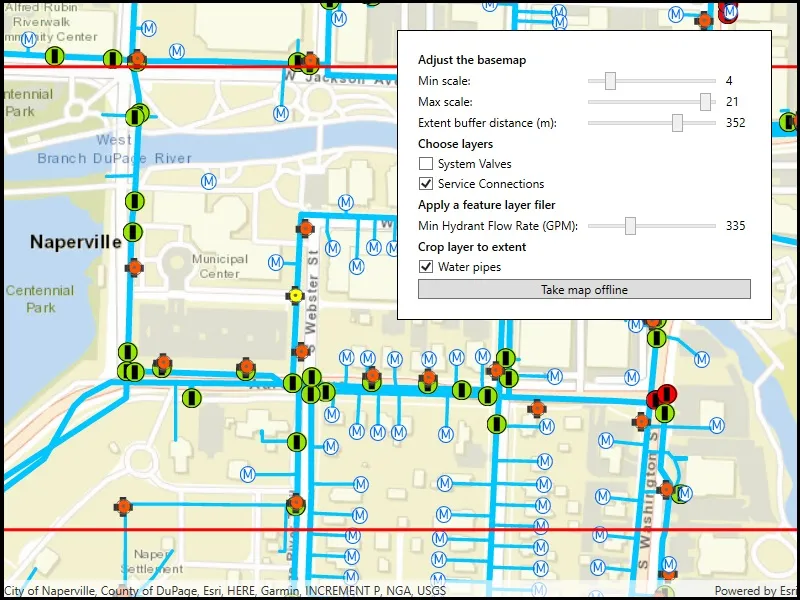
Modify the overrides parameters:
- Use the min/max scale input fields to adjust the level IDs to be taken offline for the streets basemap.
- Use the extent buffer distance input field to set the buffer radius for the streets basemap.
- Check the checkboxes for the feature operational layers you want to include in the offline map.
- Use the min hydrant flow rate input field to only download features with a flow rate higher than this value.
- Select the “Water Pipes” checkbox if you want to crop the water pipe features to the extent of the map.
After you have set up the overrides to your liking, click the “Generate offline map” button to start the download. A progress bar will display. Click the “Cancel” button if you want to stop the download. When the download is complete, the view will display the offline map. Pan around to see that it is cropped to the download area’s extent.
How it works
- Load a web map from a
PortalItem. Authenticate with the portal if required. - Create an
OfflineMapTaskwith the map. - Generate default task parameters using the extent area you want to download with
offlineMapTask.CreateDefaultGenerateOfflineMapParametersAsync(extent). - Generate additional “override” parameters using the default parameters with
offlineMapTask.CreateGenerateOfflineMapParameterOverridesAsync(parameters). - For the basemap:
- Get the parameters
OfflineMapParametersKeyfor the basemap layer. - Get the
ExportTileCacheParametersfor the basemap layer withoverrides.ExportTileCacheParameters[basemapParamKey]. - Set the level IDs you want to download with
exportTileCacheParametersLevelIDs().Add(levelID). - To buffer the extent, set the
exportTileCacheParameters.AreaOfInterestproperty. B uffered geometry can be calculated with theGeometryEngine.
- Get the parameters
- To remove operational layers from the download:
- Create a
OfflineParametersKeywith the operational layer. - Get the generate geodatabase layer options using the key with
List<GenerateLayerOption> layerOptions = overrides.GenerateGeodatabaseParameters[key].LayerOptions; - Loop through each
GenerateLayerOptionin the the list, and remove it if the layer option’s ID matches the layer’s ID.
- Create a
- To filter the features downloaded in an operational layer:
- Get the layer options for the operational layer using the directions in step 6.
- Loop through the layer options. If the option
LayerIDmatches the layer’s ID, set the filter clause withlayerOption.WhereClauseproperty and set the query option withlayerOption.QueryOptionproperty.
- To not crop a layer’s features to the extent of the offline map (default is true):
- Set the
layerOption.UseGeometryproperty tofalse.
- Set the
- Create a
GenerateOfflineMapJobwithofflineMapTask.GenerateOfflineMap(parameters, downloadPath, overrides). - Get a reference to the offline map with
job.GetResultAsync()
Relevant API
- ExportTileCacheParameters
- GenerateGeodatabaseParameters
- GenerateLayerOption
- GenerateOfflineMapJob
- GenerateOfflineMapParameterOverrides
- GenerateOfflineMapParameters
- GenerateOfflineMapResult
- OfflineMapParametersKey
- OfflineMapTask
Additional information
For applications where you just need to take all layers offline, use the standard workflow (using only GenerateOfflineMapParameters). For a simple example of how you take a map offline, please consult the “Generate offline map” sample.
Tags
adjust, download, extent, filter, LOD, offline, override, parameters, reduce, scale range, setting
Sample code
// Copyright 2021 Esri.//// Licensed under the Apache License, Version 2.0 (the "License"); you may not use this file except in compliance with the License.// You may obtain a copy of the License at: http://www.apache.org/licenses/LICENSE-2.0//// Unless required by applicable law or agreed to in writing, software distributed under the License is distributed on an// "AS IS" BASIS, WITHOUT WARRANTIES OR CONDITIONS OF ANY KIND, either express or implied. See the License for the specific// language governing permissions and limitations under the License.
using Esri.ArcGISRuntime.Data;using Esri.ArcGISRuntime.Geometry;using Esri.ArcGISRuntime.Mapping;using Esri.ArcGISRuntime.Portal;using Esri.ArcGISRuntime.Symbology;using Esri.ArcGISRuntime.Tasks;using Esri.ArcGISRuntime.Tasks.Offline;using Esri.ArcGISRuntime.UI;using System;using System.Collections.Generic;using System.IO;using System.Linq;using System.Threading.Tasks;using System.Windows;using System.Windows.Controls;using System.Windows.Threading;
namespace ArcGIS.WPF.Samples.GenerateOfflineMapWithOverrides{    [ArcGIS.Samples.Shared.Attributes.Sample(        name: "Generate offline map (overrides)",        category: "Map",        description: "Take a web map offline with additional options for each layer.",        instructions: "Modify the overrides parameters:",        tags: new[] { "LOD", "adjust", "download", "extent", "filter", "offline", "override", "parameters", "reduce", "scale range", "setting" })]    public partial class GenerateOfflineMapWithOverrides    {        // The job to generate an offline map.        private GenerateOfflineMapJob _generateOfflineMapJob;
        // The extent of the data to take offline.        private Envelope _areaOfInterest = new Envelope(-88.1541, 41.7690, -88.1471, 41.7720, SpatialReferences.Wgs84);
        // The ID for a web map item hosted on the server (water network map of Naperville IL).        private const string WebMapId = "acc027394bc84c2fb04d1ed317aac674";
        public GenerateOfflineMapWithOverrides()        {            InitializeComponent();            _ = Initialize();        }
        private async Task Initialize()        {            try            {                // Create the ArcGIS Online portal.                ArcGISPortal portal = await ArcGISPortal.CreateAsync();
                // Get the Naperville water web map item using its ID.                PortalItem webmapItem = await PortalItem.CreateAsync(portal, WebMapId);
                // Create a map from the web map item.                Map onlineMap = new Map(webmapItem);
                // Display the map in the MapView.                MyMapView.Map = onlineMap;
                // Disable user interactions on the map (no panning or zooming from the initial extent).                MyMapView.InteractionOptions = new MapViewInteractionOptions                {                    IsEnabled = false                };
                // Create a graphics overlay for the extent graphic and apply a renderer.                SimpleLineSymbol aoiOutlineSymbol = new SimpleLineSymbol(SimpleLineSymbolStyle.Solid, System.Drawing.Color.Red, 3);                GraphicsOverlay extentOverlay = new GraphicsOverlay                {                    Renderer = new SimpleRenderer(aoiOutlineSymbol)                };                MyMapView.GraphicsOverlays.Add(extentOverlay);
                // Add a graphic to show the area of interest (extent) that will be taken offline.                Graphic aoiGraphic = new Graphic(_areaOfInterest);                extentOverlay.Graphics.Add(aoiGraphic);
                // Hide the map loading progress indicator.                LoadingIndicator.Visibility = Visibility.Collapsed;
                // Clean up any existing output data folders that might exist from running this sample previously.                // The output data folder is where the results of the taking the web map offline get stored on the device.                MyMapView.Unloaded += (s, e) =>                {                    // Find output mobile map folders in the temp directory.                    string[] outputFolders = Directory.GetDirectories(Environment.ExpandEnvironmentVariables("%TEMP%"), "NapervilleWaterNetwork*");
                    // Loop through the folder names and delete them.                    foreach (string dir in outputFolders)                    {                        try                        {                            // Delete the folder.                            Directory.Delete(dir, true);                        }                        catch (Exception)                        {                            // Ignore exceptions (files might be locked, for example).                        }                    }                };            }            catch (Exception ex)            {                MessageBox.Show(ex.ToString(), "Error loading map");            }        }
        private async void TakeMapOfflineButton_Click(object sender, RoutedEventArgs e)        {            // Create a new folder for the output mobile map.            string packagePath = Path.Combine(Environment.ExpandEnvironmentVariables("%TEMP%"), @"NapervilleWaterNetwork");            int num = 1;            while (Directory.Exists(packagePath))            {                packagePath = Path.Combine(Environment.ExpandEnvironmentVariables("%TEMP%"), @"NapervilleWaterNetwork" + num.ToString());                num++;            }
            // Create the output directory.            Directory.CreateDirectory(packagePath);
            try            {                // Show the progress indicator while the job is running.                BusyIndicator.Visibility = Visibility.Visible;
                // Create an offline map task with the current (online) map.                OfflineMapTask takeMapOfflineTask = await OfflineMapTask.CreateAsync(MyMapView.Map);
                // Create the default parameters for the task, pass in the area of interest.                GenerateOfflineMapParameters parameters = await takeMapOfflineTask.CreateDefaultGenerateOfflineMapParametersAsync(_areaOfInterest);
                #region overrides
                // Generate parameter overrides for more in-depth control of the job.                GenerateOfflineMapParameterOverrides overrides = await takeMapOfflineTask.CreateGenerateOfflineMapParameterOverridesAsync(parameters);
                // Configure the overrides using helper methods.                ConfigureTileLayerOverrides(overrides);                ConfigureLayerExclusion(overrides);                CropWaterPipes(overrides);                ApplyFeatureFilter(overrides);
                // Create the job with the parameters and output location.                _generateOfflineMapJob = takeMapOfflineTask.GenerateOfflineMap(parameters, packagePath, overrides);
                #endregion overrides
                // Handle the progress changed event for the job.                _generateOfflineMapJob.ProgressChanged += OfflineMapJob_ProgressChanged;
                // Await the job to generate geodatabases, export tile packages, and create the mobile map package.                GenerateOfflineMapResult results = await _generateOfflineMapJob.GetResultAsync();
                // Check for job failure (writing the output was denied, e.g.).                if (_generateOfflineMapJob.Status != JobStatus.Succeeded)                {                    MessageBox.Show("Generate offline map package failed.", "Job status");                    BusyIndicator.Visibility = Visibility.Collapsed;                }
                // Check for errors with individual layers.                if (results.LayerErrors.Any())                {                    // Build a string to show all layer errors.                    System.Text.StringBuilder errorBuilder = new System.Text.StringBuilder();                    foreach (KeyValuePair<Layer, Exception> layerError in results.LayerErrors)                    {                        errorBuilder.AppendLine(string.Format("{0} : {1}", layerError.Key.Id, layerError.Value.Message));                    }
                    // Show layer errors.                    string errorText = errorBuilder.ToString();                    MessageBox.Show(errorText, "Layer errors");                }
                // Display the offline map.                MyMapView.Map = results.OfflineMap;
                // Apply the original viewpoint for the offline map.                MyMapView.SetViewpoint(new Viewpoint(_areaOfInterest));
                // Enable map interaction so the user can explore the offline data.                MyMapView.InteractionOptions.IsEnabled = true;
                // Hide the "Take map offline" button.                takeOfflineArea.Visibility = Visibility.Collapsed;
                // Show a message that the map is offline.                MessageArea.Visibility = Visibility.Visible;            }            catch (TaskCanceledException)            {                // Generate offline map task was canceled.                MessageBox.Show("Taking map offline was canceled");            }            catch (Exception ex)            {                // Exception while taking the map offline.                MessageBox.Show(ex.Message, "Offline map error");            }            finally            {                // Hide the activity indicator when the job is done.                BusyIndicator.Visibility = Visibility.Collapsed;            }        }
        #region overrides
        private void ConfigureTileLayerOverrides(GenerateOfflineMapParameterOverrides overrides)        {            // Create a parameter key for the first basemap layer.            OfflineMapParametersKey basemapKey = new OfflineMapParametersKey(MyMapView.Map.Basemap.BaseLayers.First());
            // Get the export tile cache parameters for the layer key.            ExportTileCacheParameters basemapParams = overrides.ExportTileCacheParameters[basemapKey];
            // Clear the existing level IDs.            basemapParams.LevelIds.Clear();
            // Get the min and max scale from the UI.            int minScale = (int)MinScaleEntry.Value;            int maxScale = (int)MaxScaleEntry.Value;
            // Re-add selected scales.            for (int i = minScale; i < maxScale; i++)            {                basemapParams.LevelIds.Add(i);            }
            // Expand the area of interest based on the specified buffer distance.            int bufferDistance = (int)ExtentBufferEntry.Value;            basemapParams.AreaOfInterest = _areaOfInterest.BufferGeodetic(bufferDistance, LinearUnits.Meters);        }
        private void ConfigureLayerExclusion(GenerateOfflineMapParameterOverrides overrides)        {            // Apply layer exclusions as specified in the UI.            if (ServiceConnCheckbox.IsChecked == false)            {                ExcludeLayerByName("Service Connection", overrides);            }
            if (SysValvesLayerCheckbox.IsChecked == false)            {                ExcludeLayerByName("System Valve", overrides);            }        }
        private void CropWaterPipes(GenerateOfflineMapParameterOverrides overrides)        {            if (CropLayerCheckbox.IsChecked == true)            {                // Get the ID of the water pipes layer.                long targetLayerId = GetServiceLayerId(GetLayerByName("Main"));
                // For each layer option.                foreach (GenerateLayerOption layerOption in GetAllLayerOptions(overrides))                {                    // If the option's LayerId matches the selected layer's ID.                    if (layerOption.LayerId == targetLayerId)                    {                        layerOption.UseGeometry = true;                    }                }            }        }
        private void ApplyFeatureFilter(GenerateOfflineMapParameterOverrides overrides)        {            // For each layer option.            foreach (GenerateLayerOption option in GetAllLayerOptions(overrides))            {                // If the option's LayerId matches the selected layer's ID.                if (option.LayerId == GetServiceLayerId(GetLayerByName("Hydrant")))                {                    // Apply the where clause.                    option.WhereClause = "FLOW >= " + (int)FlowRateFilterEntry.Value;
                    // Configure the option to use the where clause.                    option.QueryOption = GenerateLayerQueryOption.UseFilter;                }            }        }
        private IList<GenerateLayerOption> GetAllLayerOptions(GenerateOfflineMapParameterOverrides overrides)        {            // Find the first feature layer.            FeatureLayer targetLayer = MyMapView.Map.OperationalLayers.OfType<FeatureLayer>().First();
            // Get the key for the layer.            OfflineMapParametersKey layerKey = new OfflineMapParametersKey(targetLayer);
            // Use that key to get the generate options for the layer.            GenerateGeodatabaseParameters generateParams = overrides.GenerateGeodatabaseParameters[layerKey];
            // Return the layer options.            return generateParams.LayerOptions;        }
        private void ExcludeLayerByName(string layerName, GenerateOfflineMapParameterOverrides overrides)        {            // Get the feature layer with the specified name.            FeatureLayer targetLayer = GetLayerByName(layerName);
            // Get the layer's ID.            long targetLayerId = GetServiceLayerId(targetLayer);
            // Create a layer key for the selected layer.            OfflineMapParametersKey layerKey = new OfflineMapParametersKey(targetLayer);
            // Get the parameters for the layer.            GenerateGeodatabaseParameters generateParams = overrides.GenerateGeodatabaseParameters[layerKey];
            // Get the layer options for the layer.            IList<GenerateLayerOption> layerOptions = generateParams.LayerOptions;
            // Find the layer option matching the ID.            GenerateLayerOption targetLayerOption = layerOptions.First(layer => layer.LayerId == targetLayerId);
            // Remove the layer option.            layerOptions.Remove(targetLayerOption);        }
        private FeatureLayer GetLayerByName(string layerName)        {            // Get the first map in the operational layers collection that is a feature layer with name matching layerName            return MyMapView.Map.OperationalLayers.OfType<FeatureLayer>().First(layer => layer.Name == layerName);        }
        private long GetServiceLayerId(FeatureLayer layer)        {            // Find the service feature table for the layer; this assumes the layer is backed by a service feature table.            ServiceFeatureTable serviceTable = (ServiceFeatureTable)layer.FeatureTable;
            // Return the layer ID.            return serviceTable.LayerInfo.ServiceLayerId;        }
        #endregion overrides
        // Show changes in job progress.        private void OfflineMapJob_ProgressChanged(object sender, EventArgs e)        {            // Get the job.            GenerateOfflineMapJob job = sender as GenerateOfflineMapJob;
            // Dispatch to the UI thread.            Dispatcher.Invoke(() =>            {                // Show the percent complete and update the progress bar.                Percentage.Text = job.Progress > 0 ? job.Progress.ToString() + " %" : string.Empty;                ProgressBar.Value = job.Progress;            });        }
private void CancelJobButton_Click(object sender, RoutedEventArgs e) { // The user canceled the job. _generateOfflineMapJob.CancelAsync(); } }}<UserControl x:Class="ArcGIS.WPF.Samples.GenerateOfflineMapWithOverrides.GenerateOfflineMapWithOverrides" xmlns="http://schemas.microsoft.com/winfx/2006/xaml/presentation" xmlns:x="http://schemas.microsoft.com/winfx/2006/xaml" xmlns:esri="http://schemas.esri.com/arcgis/runtime/2013"> <Grid> <esri:MapView x:Name="MyMapView" />
<Border x:Name="takeOfflineArea" Width="375" Margin="30" Padding="20" HorizontalAlignment="Right" VerticalAlignment="Top" Background="White" BorderBrush="Black" BorderThickness="1"> <Grid> <Grid.Resources> <Style TargetType="TextBlock"> <Setter Property="Margin" Value="0,0,0,5" /> </Style> <Style TargetType="CheckBox" BasedOn="{StaticResource CalciteCheckBoxStyle}"> <Setter Property="Margin" Value="0,0,0,5" /> </Style> <Style TargetType="Slider" BasedOn="{StaticResource CalciteSliderStyle}"> <Setter Property="Margin" Value="0,0,5,0" /> </Style> </Grid.Resources> <Grid.ColumnDefinitions> <ColumnDefinition Width="Auto" /> <ColumnDefinition Width="*" /> <ColumnDefinition Width="Auto" /> </Grid.ColumnDefinitions> <Grid.RowDefinitions> <RowDefinition Height="Auto" /> <RowDefinition Height="Auto" /> <RowDefinition Height="Auto" /> <RowDefinition Height="Auto" /> <RowDefinition Height="Auto" /> <RowDefinition Height="Auto" /> <RowDefinition Height="Auto" /> <RowDefinition Height="Auto" /> <RowDefinition Height="Auto" /> <RowDefinition Height="Auto" /> <RowDefinition Height="Auto" /> <RowDefinition Height="Auto" /> <RowDefinition Height="Auto" /> <RowDefinition Height="Auto" /> </Grid.RowDefinitions> <TextBlock Grid.Row="0" Grid.Column="0" FontWeight="SemiBold" Text="Adjust the basemap" /> <TextBlock Grid.Row="1" Grid.Column="0" Text="Min scale:" /> <Slider x:Name="MinScaleEntry" Grid.Row="1" Grid.Column="1" Maximum="23" Minimum="0" Value="0" /> <TextBlock Grid.Row="1" Grid.Column="2" Text="{Binding ElementName=MinScaleEntry, Path=Value, StringFormat=n0}" /> <TextBlock Grid.Row="2" Grid.Column="0" Text="Max scale:" /> <Slider x:Name="MaxScaleEntry" Grid.Row="2" Grid.Column="1" Maximum="23" Minimum="0" Value="23" /> <TextBlock Grid.Row="2" Grid.Column="2" Text="{Binding ElementName=MaxScaleEntry, Path=Value, StringFormat=n0}" /> <TextBlock Grid.Row="3" Grid.Column="0" Text="Extent buffer distance (m):" /> <Slider x:Name="ExtentBufferEntry" Grid.Row="3" Grid.Column="1" Maximum="500" Minimum="0" Value="250" /> <TextBlock Grid.Row="3" Grid.Column="2" Text="{Binding ElementName=ExtentBufferEntry, Path=Value, StringFormat=n0}" /> <TextBlock Grid.Row="4" Grid.Column="0" FontWeight="SemiBold" Text="Choose layers" /> <CheckBox x:Name="SysValvesLayerCheckbox" Grid.Row="5" Grid.Column="0" Content="System Valves" IsChecked="True" /> <CheckBox x:Name="ServiceConnCheckbox" Grid.Row="6" Grid.Column="0" Content="Service Connections" /> <TextBlock Grid.Row="7" Grid.Column="0" Margin="0,0,0,5" FontWeight="SemiBold" Text="Apply a feature layer filer" /> <TextBlock Grid.Row="8" Grid.Column="0" Margin="0,0,5,5" Text="Min Hydrant Flow Rate (GPM):" /> <Slider x:Name="FlowRateFilterEntry" Grid.Row="8" Grid.Column="1" Maximum="999" Minimum="0" Value="500" /> <TextBlock Grid.Row="8" Grid.Column="2" MinWidth="25" Text="{Binding ElementName=FlowRateFilterEntry, Path=Value, StringFormat=n0}" /> <TextBlock Grid.Row="9" Grid.Column="0" Margin="0,0,0,5" FontWeight="SemiBold" Text="Crop layer to extent" /> <CheckBox x:Name="CropLayerCheckbox" Grid.Row="10" Grid.Column="0" Content="Water pipes" /> <Button Grid.Row="11" Grid.Column="0" Grid.ColumnSpan="3" Click="TakeMapOfflineButton_Click" Content="Take map offline" IsEnabled="True" /> </Grid> </Border>
<Border x:Name="MessageArea" Width="450" Margin="30" Padding="5" HorizontalAlignment="Right" VerticalAlignment="Top" Background="White" BorderBrush="Black" BorderThickness="1" Visibility="Collapsed"> <StackPanel> <TextBlock Margin="10" HorizontalAlignment="Center" VerticalAlignment="Center" FontWeight="Bold" Text="Map is offline!" /> </StackPanel> </Border>
<Grid x:Name="BusyIndicator" Background="#807f7f7f" Visibility="Collapsed"> <Grid HorizontalAlignment="Center" VerticalAlignment="Center"> <Grid.RowDefinitions> <RowDefinition Height="auto" /> <RowDefinition Height="auto" /> <RowDefinition Height="auto" /> </Grid.RowDefinitions> <TextBlock Margin="10" HorizontalAlignment="Center" VerticalAlignment="Center" FontSize="18" Foreground="White"> <Run Text="Generating offline map... " /> <Run x:Name="Percentage" Text="" /> </TextBlock> <ProgressBar x:Name="ProgressBar" Grid.Row="1" Width="100" Height="10" Margin="0,0,0,10" HorizontalAlignment="Center" VerticalAlignment="Center" IsEnabled="True" Maximum="100" Minimum="0" /> <Button Grid.Row="2" Width="100" HorizontalAlignment="Center" Click="CancelJobButton_Click" Content="Cancel" /> </Grid> </Grid> <Grid x:Name="LoadingIndicator" Background="#807f7f7f" Visibility="Visible"> <Grid HorizontalAlignment="Center" VerticalAlignment="Center"> <Grid.RowDefinitions> <RowDefinition Height="auto" /> <RowDefinition Height="auto" /> </Grid.RowDefinitions> <TextBlock Margin="10" FontSize="18" Foreground="White" Text="Loading online map..." /> <ProgressBar Grid.Row="1" Width="100" Height="10" HorizontalAlignment="Center" VerticalAlignment="Center" IsEnabled="True" IsIndeterminate="True" /> </Grid> </Grid> </Grid></UserControl>