Create a notification every time a given location data source has entered and/or exited a set of features or graphics.
Use case
Geotriggers can be used to notify users when they have entered or exited a geofence by monitoring a given set of features or graphics. They could be used to display contextual information to museum visitors about nearby exhibits, notify hikers when they have wandered off their desired trail, notify dispatchers when service workers arrive at a scene, or more.
How to use the sample
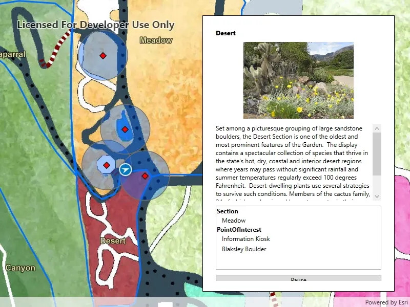
Observe a virtual walking tour of the Santa Barbara Botanic Garden. Information about the user’s current Garden Section, as well as information about nearby points of interest within 10 meters will display or be removed from the UI when the user enters or exits the buffer of each feature.
How it works
- Create a
GeotriggerFeedwith aLocationDataSourceclass (in this case, aSimulatedLocationDataSource). - Create a
FeatureFenceParametersclass from aServiceFeatureTable, a buffer distance at which to monitor each feature, an Arcade Expression, and a name for the specific geotrigger. - Create a
FenceGeotriggerwith the geotrigger feed, aFenceRuleType, and the fence parameters. - Create a
GeotriggerMonitorwith the fence geotrigger and callGeotriggerMonitor.StartAsync()to begin listening for events that meet theFenceRuleType. - When a
GeotriggerMonitor.Notificationemits, capture theGeotriggerNotificationInfo. - For more information about the feature that triggered the notification, cast the
GeotriggerNotificationInfoto aFenceGeotriggerNotificationInfoand callFenceGeotriggerNotificationInfo.. - Depending on the
FenceGeotriggerNotificationInfo.FenceNotificationTypedisplay or hide information on the UI from theGeoElement’s attributes.
Relevant API
- ArcadeExpression
- FeatureFenceParameters
- FenceGeotrigger
- FenceGeotriggerNotificationInfo
- FenceRuleType
- GeoElement
- Geotrigger
- GeotriggerFeed
- GeotriggerMonitor
- GeotriggerNotificationInfo
- ServiceFeatureTable
- SimulatedLocationDataSource
About the data
This sample uses the Santa Barbara Botanic Garden Geotriggers Sample ArcGIS Online Web Map which includes a georeferenced map of the garden as well as select polygon and point features to denote garden sections and points of interest. Description text and attachment images in the feature layers were provided by the Santa Barbara Botanic Garden and more information can be found on the Explore > Sections portion of their website. All assets are used with permission from the Santa Barbara Botanic Garden. For more information, visit the Santa Barbara Botanic Garden website.
Tags
alert, arcade, fence, geofence, geotrigger, location, navigation, notification, notify, routing, trigger
Sample code
// Copyright 2021 Esri.//// Licensed under the Apache License, Version 2.0 (the "License"); you may not use this file except in compliance with the License.// You may obtain a copy of the License at: http://www.apache.org/licenses/LICENSE-2.0//// Unless required by applicable law or agreed to in writing, software distributed under the License is distributed on an// "AS IS" BASIS, WITHOUT WARRANTIES OR CONDITIONS OF ANY KIND, either express or implied. See the License for the specific// language governing permissions and limitations under the License.
using Esri.ArcGISRuntime;using Esri.ArcGISRuntime.Data;using Esri.ArcGISRuntime.Geometry;using Esri.ArcGISRuntime.Geotriggers;using Esri.ArcGISRuntime.Location;using Esri.ArcGISRuntime.Mapping;using Esri.ArcGISRuntime.UI;using System;using System.Collections.Generic;using System.Collections.ObjectModel;using System.IO;using System.Linq;using System.Threading.Tasks;using System.Windows;using System.Windows.Data;using System.Windows.Media.Imaging;
namespace ArcGIS.WPF.Samples.LocationDrivenGeotriggers{    [ArcGIS.Samples.Shared.Attributes.Sample(        name: "Set up location-driven Geotriggers",        category: "Location",        description: "Create a notification every time a given location data source has entered and/or exited a set of features or graphics.",        instructions: "Observe a virtual walking tour of the Santa Barbara Botanic Garden. Information about the user's current Garden Section, as well as information about nearby points of interest within 10 meters will display or be removed from the UI when the user enters or exits the buffer of each feature.",        tags: new[] { "alert", "arcade", "fence", "geofence", "geotrigger", "location", "navigation", "notification", "notify", "routing", "trigger" })]    public partial class LocationDrivenGeotriggers    {        private string _tourPolylineJSON = "{\"paths\":[[[-119.709881177746,34.4570041646846],[-119.709875813328,34.4570152227745],[-119.709869107805,34.4570240692453],[-119.709859720074,34.4570351273326],[-119.709853014551,34.4570539260775],[-119.709847650133,34.4570760422426],[-119.709848991238,34.4570926293626],[-119.70985569676,34.4571103222869],[-119.709873131119,34.4571202745552],[-119.709889224373,34.4571302268223],[-119.709902635418,34.4571357558591],[-119.709910682045,34.4571600836165],[-119.709910682045,34.4571744591062],[-119.709902635418,34.4571833055602],[-119.709889224373,34.4571910462067],[-119.70988251885,34.4571965752394],[-119.70988251885,34.4572032100782],[-119.709889224373,34.4572175855605],[-119.709898612104,34.4572264320099],[-119.709912023149,34.4572341726524],[-119.709901294313,34.4572419132941],[-119.709895929895,34.4572507597409],[-119.709897271,34.4572596061868],[-119.709902635418,34.4572728758539],[-119.709902635418,34.4572828281028],[-119.70990934094,34.457294991961],[-119.709912023149,34.4573038384022],[-119.709886542164,34.4573115790375],[-119.709861061178,34.4573248486963],[-119.709843626819,34.4573414357669],[-119.709836921297,34.4573668692686],[-119.709843626819,34.4573934085666],[-119.709827533565,34.4574055724087],[-119.709791323744,34.4574188420525],[-119.709749749504,34.4574332174977],[-119.709709516369,34.4574431697275],[-119.709734997354,34.4574807670294],[-119.709748062646,34.4575248306656],[-119.709757450378,34.4575635337324],[-119.709770861423,34.457600025179],[-119.709785613572,34.4576387282109],[-119.70980573014,34.4576730080242],[-119.709815117871,34.4577117110223],[-119.709821823394,34.4577504140025],[-119.709821823394,34.4577869053674],[-119.709821823394,34.4578256083127],[-119.70981780008,34.4578609938471],[-119.709819141185,34.457906331541],[-119.70981460448,34.4579890675855],[-119.709818627793,34.4580675790658],[-119.70982667442,34.4581118108532],[-119.709832038838,34.4581471962662],[-119.709834721047,34.4581947453913],[-119.709836062152,34.4582323423548],[-119.709834721047,34.4582787856393],[-119.709805216748,34.4583429215611],[-119.709759619195,34.4584026342716],[-119.709700610597,34.4584612411497],[-119.709645400048,34.4585103926263],[-119.709566274882,34.4585457778704],[-119.709493855239,34.4585944325566],[-119.709458986522,34.458622077252],[-119.709424117805,34.4586198656767],[-119.709386566878,34.4586110193749],[-119.70935438037,34.4586110193749],[-119.709339628221,34.4586231830396],[-119.709324876071,34.4586585682359],[-119.709306100608,34.4586862129101],[-119.709269890786,34.4587171749343],[-119.709244409801,34.4587238096523],[-119.709229657651,34.4587293385835],[-119.709212223293,34.4587459253751],[-119.70919076562,34.4587945799446],[-119.709174672366,34.4588503400161],[-119.709157238008,34.4589288506865],[-119.709153214694,34.4589951976744],[-119.709155896903,34.4590449578807],[-119.70916394353,34.4590958238387],[-119.709186742307,34.4591323146156],[-119.709218928815,34.4591621706939],[-119.709237704278,34.4591831805204],[-119.709241727592,34.4592252001575],[-119.709238133851,34.459258658624],[-119.709219358388,34.4592796684262],[-119.709207288447,34.4592962551085],[-119.709208629552,34.4593084186733],[-119.709271661463,34.4593791884701],[-119.709310553494,34.4594267368937],[-119.709330670062,34.4594510639836],[-119.709353468838,34.4595008239182],[-119.70936285657,34.4595362087426],[-119.709423221989,34.4595943612845],[-119.709455408497,34.4596297460692],[-119.709487595005,34.459665130839],[-119.709507711573,34.4596817174446],[-119.709523804827,34.4596861405389],[-119.709557332439,34.4596894578594],[-119.709586836739,34.4596894578594],[-119.709593542261,34.4596772943501],[-119.709590860052,34.4596496500041],[-119.709572084589,34.4595777746615],[-119.709566720171,34.4595313320996],[-119.709578790112,34.4595136396883],[-119.709590860052,34.4594992646013],[-119.709627069874,34.4594882068404],[-119.709675349636,34.4595567649343],[-119.709735699339,34.4596197941001],[-119.709775932474,34.4596795058974],[-119.709802754564,34.4597126790997],[-119.709832258863,34.4597359003334],[-119.70986712758,34.4597171021923],[-119.70986980979,34.4596839289918],[-119.709865786476,34.4596308518435],[-119.709876515312,34.4595788804365],[-119.70988187973,34.4595346494263],[-119.709879197521,34.4594926299449],[-119.709852375431,34.4594539277723],[-119.709806777878,34.4593953215911],[-119.709767885847,34.4593212344729],[-119.709720947189,34.4592195028005],[-119.709708720088,34.4591478732967],[-119.709710061193,34.4591058536206],[-119.709707378984,34.459079314867],[-119.709652393699,34.4590262373344],[-119.709617524982,34.4589499383221],[-119.709626771268,34.4588695962162],[-119.709683097658,34.4588032491285],[-119.709730036316,34.4587391135603],[-119.709759540615,34.4586993052518],[-119.7097850216,34.4586650258598],[-119.710059948024,34.4587744987075],[-119.710104204473,34.4587932970608],[-119.710128443889,34.4587649224307],[-119.71019415801,34.4587096331253],[-119.710273283176,34.4586731421637],[-119.71031619852,34.4586532379961],[-119.710367160491,34.4586023717685],[-119.710392641477,34.4585747270665],[-119.710432874612,34.4585083797445],[-119.710471766643,34.4584453497398],[-119.710505294256,34.4584165991955],[-119.710575487456,34.4583689119728],[-119.710705574593,34.4583136224052],[-119.710780676446,34.4582627559707],[-119.710839685044,34.4582030431601],[-119.710895995717,34.4581546042213],[-119.710948298793,34.458095997128],[-119.710988531928,34.4580263320391],[-119.711015354018,34.4579511379096],[-119.711011330705,34.4579102234284],[-119.710985849719,34.4578847900921],[-119.710946957688,34.4578715205223],[-119.710779319625,34.4578847900921],[-119.71073908649,34.4578847900921],[-119.7107122644,34.4578604625458],[-119.71069751225,34.4578295002039],[-119.710674713473,34.4578095958352],[-119.710642526965,34.4577996436491],[-119.710614363771,34.457830606002],[-119.71057547174,34.4578571451526],[-119.710539261918,34.4578737321174],[-119.71049500547,34.4578858958895],[-119.710452090125,34.4578836842947],[-119.710413198095,34.4578748379149],[-119.710375647168,34.4578527219614],[-119.710336755138,34.4578350291944],[-119.710299204211,34.4578107016336],[-119.71027506433,34.4577885856631],[-119.710269605616,34.4577886418169],[-119.710240101317,34.4577510446536],[-119.710198527077,34.4576758502763],[-119.710154270628,34.4575984442288],[-119.710112696389,34.4575265671206],[-119.710044300059,34.4574381029023],[-119.709978842634,34.4573543166616],[-119.709966772693,34.4573410470074],[-119.709972137111,34.4573200367174],[-119.70997481932,34.4573023438375],[-119.709973478216,34.4572846509538],[-119.709970796007,34.457259217427],[-119.709931903976,34.4572348896984],[-119.709914469617,34.4572337838924],[-119.709893011945,34.4572171968005],[-119.709884965318,34.4571972922858],[-119.709902232039,34.4571821133624],[-119.70991161977,34.457167737874],[-119.709907596457,34.4571389868898],[-119.709919666397,34.4571235055865],[-119.709922348606,34.4571047068572],[-119.709918325293,34.4570836965077],[-119.709919666397,34.4570648977695],[-119.70992637192,34.4570516280694],[-119.709933077442,34.4570339351326],[-119.709935759651,34.4570151363832],[-119.709927713024,34.4570062899114],[-119.70991161977,34.4570018666751],[-119.709883456576,34.4570040782933]]],\"spatialReference\":{\"wkid\":4326,\"latestWkid\":4326}}";
        private SimulatedLocationDataSource _simulatedSource;        private LocationGeotriggerFeed _geotriggerFeed;
        private ServiceFeatureTable _gardenSections;        private ServiceFeatureTable _gardenPoints;
        private GeotriggerMonitor _sectionMonitor;        private GeotriggerMonitor _pointsMonitor;
        private List<GeotriggerFeature> _features = new List<GeotriggerFeature>();        private ObservableCollection<GeotriggerFeature> _displayedFeatures = new ObservableCollection<GeotriggerFeature>();
        public LocationDrivenGeotriggers()        {            InitializeComponent();            _ = Initialize();        }
        private async Task Initialize()        {            try            {                // This sample uses a web map with a predefined tile basemap, feature styles, and labels.                MyMapView.Map = new Map(new Uri("https://www.arcgis.com/home/item.html?id=6ab0e91dc39e478cae4f408e1a36a308"));                await MyMapView.Map.LoadAsync();
                // Get service feature tables from the map to create GeotriggerMonitors for.                _gardenSections = ((FeatureLayer)MyMapView.Map.OperationalLayers[0]).FeatureTable as ServiceFeatureTable;                _gardenPoints = ((FeatureLayer)MyMapView.Map.OperationalLayers[2]).FeatureTable as ServiceFeatureTable;
                // Create a simulated location data source for simulating a path through the data.                _simulatedSource = new SimulatedLocationDataSource();
                // Create SimulationParameters starting at the current time, velocity, and horizontal and vertical accuracy.                SimulationParameters simulationParameters = new SimulationParameters(DateTime.Now, 3.0, 0.0, 0.0);
                // Use the polyline as defined above or from this AGOL GeoJSON to define the path. Retrieved from https://https://arcgisruntime.maps.arcgis.com/home/item.html?id=2a346cf1668d4564b8413382ae98a956                _simulatedSource.SetLocationsWithPolyline(Geometry.FromJson(_tourPolylineJSON) as Polyline, simulationParameters);
                // Set up the location display.                MyMapView.LocationDisplay.DataSource = _simulatedSource;                MyMapView.LocationDisplay.AutoPanMode = LocationDisplayAutoPanMode.Recenter;                MyMapView.LocationDisplay.InitialZoomScale = 1000;                await _simulatedSource?.StartAsync();
                // Set the list view items source.                LocationList.ItemsSource = _displayedFeatures;
                // Create a group description to distinguish features in the list view.                CollectionViewSource.GetDefaultView(LocationList.ItemsSource).GroupDescriptions.Add(new PropertyGroupDescription("Source"));
                // LocationGeotriggerFeed will be used in instantiating a FenceGeotrigger.                _geotriggerFeed = new LocationGeotriggerFeed(_simulatedSource);
                // Create monitors for sections and points of interest.                _sectionMonitor = CreateGeotriggerMonitor(_gardenSections, 0.0, "Section Geotrigger");                _pointsMonitor = CreateGeotriggerMonitor(_gardenPoints, 10.0, "POI Geotrigger");
                // Start both Geotrigger monitors.                await _sectionMonitor?.StartAsync();                await _pointsMonitor?.StartAsync();            }            catch (Exception ex)            {                MessageBox.Show(ex.Message, ex.GetType().Name, MessageBoxButton.OK, MessageBoxImage.Error);            }        }
        private GeotriggerMonitor CreateGeotriggerMonitor(ServiceFeatureTable table, double bufferSize, string triggerName)        {            // Create parameters for the fence.            FeatureFenceParameters fenceParameters = new FeatureFenceParameters(table, bufferSize);
            // The ArcadeExpression defined in the following FenceGeotrigger returns the value for the "name" field of the feature that triggered the monitor.            FenceGeotrigger fenceTrigger = new FenceGeotrigger(_geotriggerFeed, FenceRuleType.EnterOrExit, fenceParameters, new ArcadeExpression("$fenceFeature.name"), triggerName);
            // Create the monitor and set its event handler for notifications.            GeotriggerMonitor geotriggerMonitor = new GeotriggerMonitor(fenceTrigger);            geotriggerMonitor.Notification += HandleGeotriggerNotification;
            return geotriggerMonitor;        }
        private void HandleGeotriggerNotification(object sender, GeotriggerNotificationInfo info)        {            // The collection used for the list view is changed, and must be modified on a UI thread.            Application.Current.Dispatcher.Invoke(new Action(async () =>            {                if (info is FenceGeotriggerNotificationInfo fenceInfo)                {                    if (fenceInfo.FenceNotificationType == FenceNotificationType.Entered)                    {                        if (!_features.Any(f => f.Name == fenceInfo.Message))                        {                            try                            {                                // Get the feature that's fence has been entered.                                ArcGISFeature feature = fenceInfo.FenceGeoElement as ArcGISFeature;
                                // Get the description for the feature.                                string description = feature.Attributes["desc_raw"].ToString();
                                // Get the attachments for the feature.                                IReadOnlyList<Attachment> attach = await feature.GetAttachmentsAsync();
                                // Load the attachment data into a bitmap image.                                Stream attachmentDataStream = await attach.First().GetDataAsync();                                BitmapImage bitmapImage = new BitmapImage();                                bitmapImage.BeginInit();                                bitmapImage.StreamSource = attachmentDataStream;                                bitmapImage.CacheOption = BitmapCacheOption.OnLoad;                                bitmapImage.EndInit();
                                // Determine which geotriggermonitor the notification came from.                                MonitorSource source = (info.GeotriggerMonitor == _sectionMonitor) ? MonitorSource.Section : MonitorSource.PointOfInterest;
                                // Create an object to group the information together for interface use.                                GeotriggerFeature geotriggerFeature = new GeotriggerFeature                                {                                    Name = fenceInfo.Message,                                    Description = description,                                    Image = bitmapImage,                                    Source = source,                                };
                                // Add the object to the list of known feature information.                                _features.Add(geotriggerFeature);                            }                            catch (Exception ex)                            {                                MessageBox.Show(ex.Message, ex.GetType().Name, MessageBoxButton.OK, MessageBoxImage.Error);                            }                        }
                        // Add the feature to the list view.                        _displayedFeatures.Add(_features.First(f => f.Name == fenceInfo.Message));                    }                    else                    {                        // Remove the feature from the list view.                        if (_displayedFeatures.FirstOrDefault(f => f.Name == fenceInfo.Message) is GeotriggerFeature feature)                        {                            _displayedFeatures.Remove(feature);                        }                    }                }            }));        }
        private void DisplayData(GeotriggerFeature geotriggerFeature)        {            // Update the UI with data about the selected feature.            NameLabel.Content = geotriggerFeature.Name;            Description.Text = geotriggerFeature.Description;            LocationImage.Source = geotriggerFeature.Image;        }
        private void LocationList_SelectionChanged(object sender, System.Windows.Controls.SelectionChangedEventArgs e)        {            if (LocationList.SelectedItem is GeotriggerFeature feature)            {                DisplayData(feature);            }        }
        private void PlayPauseClicked(object sender, RoutedEventArgs e)        {            // Start and stop the simulated location on a button press.            if (_simulatedSource.Status == LocationDataSourceStatus.Started)            {                _simulatedSource.StopAsync();                PlayPauseButton.Content = "Play";            }            else            {                _simulatedSource.StartAsync();                PlayPauseButton.Content = "Pause";            }        }    }
    public enum MonitorSource    { Section, PointOfInterest };
    // Class to store attributes of features together.    public class GeotriggerFeature    {        public string Name { get; set; }
        public string Description { get; set; }
        public BitmapImage Image { get; set; }
public MonitorSource Source { get; set; } }}<UserControl x:Class="ArcGIS.WPF.Samples.LocationDrivenGeotriggers.LocationDrivenGeotriggers" xmlns="http://schemas.microsoft.com/winfx/2006/xaml/presentation" xmlns:x="http://schemas.microsoft.com/winfx/2006/xaml" xmlns:esri="http://schemas.esri.com/arcgis/runtime/2013"> <Grid> <esri:MapView x:Name="MyMapView" /> <Border Style="{StaticResource BorderStyle}"> <ScrollViewer> <StackPanel> <Label x:Name="NameLabel" FontWeight="ExtraBold" /> <Image x:Name="LocationImage" Height="150" Margin="5" /> <ScrollViewer Height="150" Margin="5"> <TextBlock x:Name="Description" TextWrapping="Wrap" /> </ScrollViewer> <Label Content="Click on features in list to see information." /> <ListView x:Name="LocationList" Height="125" Margin="5" DisplayMemberPath="Name" SelectionChanged="LocationList_SelectionChanged" SelectionMode="Single"> <ListView.GroupStyle> <GroupStyle> <GroupStyle.HeaderTemplate> <DataTemplate> <TextBlock FontSize="12" FontWeight="Bold" Text="{Binding Name}" /> </DataTemplate> </GroupStyle.HeaderTemplate> </GroupStyle> </ListView.GroupStyle> </ListView> <Button x:Name="PlayPauseButton" Margin="5" Click="PlayPauseClicked" Content="Pause" /> </StackPanel> </ScrollViewer> </Border> </Grid></UserControl>