Extrude features based on their attributes.
Use case
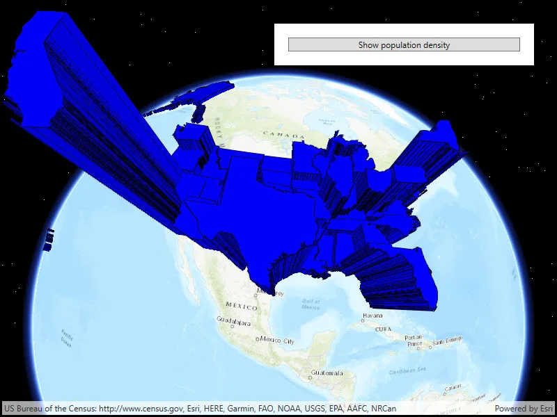
Extrusion is the process of stretching a flat, 2D shape vertically to create a 3D object in a scene. For example, you can extrude building polygons by a height value to create three-dimensional building shapes.
How to use the sample
Press the button to switch between using population density and total population for extrusion. Higher extrusion directly corresponds to higher attribute values.
How it works
- Create a
ServiceFeatureTablefrom a URL. - Create a feature layer from the service feature table.
- Make sure to set the rendering mode to dynamic.
- Apply a
SimpleRendererto the feature layer. - Set
ExtrusionModeof render,renderer.SceneProperties.ExtrusionMode = SceneProperties.ExtrusionMode.BaseHeight. - Set extrusion expression of renderer,
renderer.SceneProperties.ExtrusionExpression = "[POP2007]/ 10".
Relevant API
- ExtrusionExpression
- ExtrusionMode
- FeatureLayer
- SceneProperties
- ServiceFeatureTable
- SimpleRenderer
Tags
3D, extrude, extrusion, extrusion expression, height, renderer, scene
Sample code
// Copyright 2018 Esri.//// Licensed under the Apache License, Version 2.0 (the "License"); you may not use this file except in compliance with the License.// You may obtain a copy of the License at: http://www.apache.org/licenses/LICENSE-2.0//// Unless required by applicable law or agreed to in writing, software distributed under the License is distributed on an// "AS IS" BASIS, WITHOUT WARRANTIES OR CONDITIONS OF ANY KIND, either express or implied. See the License for the specific// language governing permissions and limitations under the License.
using Esri.ArcGISRuntime.Data;using Esri.ArcGISRuntime.Geometry;using Esri.ArcGISRuntime.Mapping;using Esri.ArcGISRuntime.Symbology;using Esri.ArcGISRuntime.UI;using System;using System.Windows;
namespace ArcGIS.WPF.Samples.FeatureLayerExtrusion{    [ArcGIS.Samples.Shared.Attributes.Sample(        name: "Feature layer extrusion",        category: "Symbology",        description: "Extrude features based on their attributes.",        instructions: "Press the button to switch between using population density and total population for extrusion. Higher extrusion directly corresponds to higher attribute values.",        tags: new[] { "3D", "extrude", "extrusion", "extrusion expression", "height", "renderer", "scene" })]    public partial class FeatureLayerExtrusion    {        public FeatureLayerExtrusion()        {            InitializeComponent();
            Initialize();        }
        private void Initialize()        {            try            {                // Define the Uri for the service feature table (US state polygons).                Uri serviceFeatureTableUri = new Uri("https://sampleserver6.arcgisonline.com/arcgis/rest/services/Census/MapServer/3");
                // Create a new service feature table from the Uri.                ServiceFeatureTable myServiceFeatureTable = new ServiceFeatureTable(serviceFeatureTableUri);
                // Create a new feature layer from the service feature table.                FeatureLayer myFeatureLayer = new FeatureLayer(myServiceFeatureTable)                {                    // Set the rendering mode of the feature layer to be dynamic (needed for extrusion to work).                    RenderingMode = FeatureRenderingMode.Dynamic                };
                // Create a new simple line symbol for the feature layer.                SimpleLineSymbol mySimpleLineSymbol = new SimpleLineSymbol(SimpleLineSymbolStyle.Solid, System.Drawing.Color.Black, 1);
                // Create a new simple fill symbol for the feature layer.                SimpleFillSymbol mysimpleFillSymbol = new SimpleFillSymbol(SimpleFillSymbolStyle.Solid, System.Drawing.Color.Blue, mySimpleLineSymbol);
                // Create a new simple renderer for the feature layer.                SimpleRenderer mySimpleRenderer = new SimpleRenderer(mysimpleFillSymbol);
                // Get the scene properties from the simple renderer.                RendererSceneProperties myRendererSceneProperties = mySimpleRenderer.SceneProperties;
                // Set the extrusion mode for the scene properties.                myRendererSceneProperties.ExtrusionMode = ExtrusionMode.AbsoluteHeight;
                // Set the initial extrusion expression to the 2007 population field from the data set divided by 10.                // This reduces the height of the extruded features for better visibility.                myRendererSceneProperties.ExtrusionExpression = "[POP2007] / 10";
                // Set the feature layer's renderer to the define simple renderer.                myFeatureLayer.Renderer = mySimpleRenderer;
                // Create a new scene with the topographic backdrop.                Scene myScene = new Scene(BasemapStyle.ArcGISTopographic);
                // Set the scene view's scene to the newly create one.                MySceneView.Scene = myScene;
                // Add the feature layer to the scene's operational layer collection.                myScene.OperationalLayers.Add(myFeatureLayer);
                // Create a new map point to define where to look on the scene view.                MapPoint myMapPoint = new MapPoint(-10974490, 4814376, 0, SpatialReferences.WebMercator);
                // Create a new orbit location camera controller using the map point and defined distance.                OrbitLocationCameraController myOrbitLocationCameraController = new OrbitLocationCameraController(myMapPoint, 20000000);
                // Set the scene view's camera controller to the orbit location camera controller.                MySceneView.CameraController = myOrbitLocationCameraController;            }            catch (Exception ex)            {                // Something went wrong, display the error.                MessageBox.Show(ex.ToString());            }        }
        private void ChangeExtrusionExpression()        {            // Get the first layer from the scene view's operation layers, it should be a feature layer.            FeatureLayer myFeatureLayer = (FeatureLayer)MySceneView.Scene.OperationalLayers[0];
            // Get the renderer from the feature layer.            Renderer myRenderer = myFeatureLayer.Renderer;
            // Get the scene properties from the feature layer's renderer.            RendererSceneProperties myRendererSceneProperties = myRenderer.SceneProperties;
            // Toggle the feature layer's scene properties renderer extrusion expression and change the button text.            if (ToggleDataButton.Content.ToString() == "Show population density")            {                // An offset of 100000 is added to ensure that polygons for large areas (like Alaska)                // with low populations will be extruded above the curvature of the Earth.                myRendererSceneProperties.ExtrusionExpression = "[POP07_SQMI] * 5000 + 100000";                ToggleDataButton.Content = "Show total population";            }            else if (ToggleDataButton.Content.ToString() == "Show total population")            {                myRendererSceneProperties.ExtrusionExpression = "[POP2007] / 10";                ToggleDataButton.Content = "Show population density";            }        }
private void Button_ToggleExtrusionData_Click(object sender, RoutedEventArgs e) { // Call the function to change the feature layer's renderer scene properties extrusion expression. ChangeExtrusionExpression(); } }}<UserControl x:Class="ArcGIS.WPF.Samples.FeatureLayerExtrusion.FeatureLayerExtrusion" xmlns="http://schemas.microsoft.com/winfx/2006/xaml/presentation" xmlns:x="http://schemas.microsoft.com/winfx/2006/xaml" xmlns:esri="http://schemas.esri.com/arcgis/runtime/2013"> <Grid> <esri:SceneView x:Name="MySceneView" /> <Border Style="{StaticResource BorderStyle}"> <StackPanel> <Button x:Name="ToggleDataButton" Click="Button_ToggleExtrusionData_Click" Content="Show population density" /> </StackPanel> </Border> </Grid></UserControl>