Generate a local geodatabase from an online feature service.
Use case
Generating geodatabases is the first step toward taking a feature service offline. It allows you to save features locally for offline display.
How to use the sample
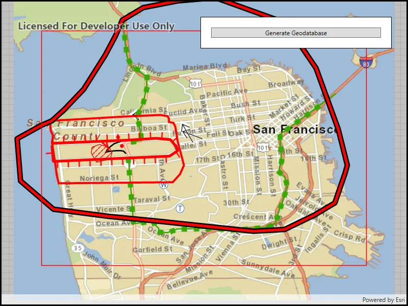
Zoom to any extent. Then click the generate button to generate a geodatabase of features from a feature service filtered to the current extent. A red outline will show the extent used. The job’s progress is shown while the geodatabase is generated.
How it works
- Create a
GeodatabaseSyncTaskwith the URL of the feature service and load it. - Create
GenerateGeodatabaseReplicaParametersspecifying the extent and whether to include attachments. - Create a
GenerateGeodatabaseReplicaJobwithgeodatabaseSyncTask.GenerateGeodatabaseReplicaAsync(parameters, downloadPath). Start the job withjob.Start(). - When the job is done,
job.GetResultAsync()will return the geodatabase. Inside the geodatabase are feature tables which can be used to add feature layers to the map. - Call
syncTask.UnregisterGeodatabaseAsync(geodatabase)after generation when you’re not planning on syncing changes to the service.
Relevant API
- GenerateGeodatabaseReplicaJob
- GenerateGeodatabaseReplicaParameters
- Geodatabase
- GeodatabaseSyncTask
Tags
disconnected, local geodatabase, offline, replica, sync
Sample code
// Copyright 2018 Esri.//// Licensed under the Apache License, Version 2.0 (the "License"); you may not use this file except in compliance with the License.// You may obtain a copy of the License at: http://www.apache.org/licenses/LICENSE-2.0//// Unless required by applicable law or agreed to in writing, software distributed under the License is distributed on an// "AS IS" BASIS, WITHOUT WARRANTIES OR CONDITIONS OF ANY KIND, either express or implied. See the License for the specific// language governing permissions and limitations under the License.
using ArcGIS.Samples.Managers;using Esri.ArcGISRuntime.ArcGISServices;using Esri.ArcGISRuntime.Data;using Esri.ArcGISRuntime.Geometry;using Esri.ArcGISRuntime.Mapping;using Esri.ArcGISRuntime.Symbology;using Esri.ArcGISRuntime.Tasks;using Esri.ArcGISRuntime.Tasks.Offline;using Esri.ArcGISRuntime.UI;using System;using System.Drawing;using System.IO;using System.Linq;using System.Threading.Tasks;using System.Windows;
namespace ArcGIS.WPF.Samples.GenerateGeodatabaseReplica{    [ArcGIS.Samples.Shared.Attributes.Sample(        name: "Generate geodatabase replica from feature service",        category: "Data",        description: "Generate a local geodatabase from an online feature service.",        instructions: "Zoom to any extent. Then click the generate button to generate a geodatabase of features from a feature service filtered to the current extent. A red outline will show the extent used. The job's progress is shown while the geodatabase is generated.",        tags: new[] { "disconnected", "local geodatabase", "offline", "replica", "sync" })]    [ArcGIS.Samples.Shared.Attributes.OfflineData("e4a398afe9a945f3b0f4dca1e4faccb5")]    public partial class GenerateGeodatabaseReplica    {        // URI for a feature service that supports geodatabase generation.        private Uri _featureServiceUri = new Uri("https://sampleserver6.arcgisonline.com/arcgis/rest/services/Sync/WildfireSync/FeatureServer");
        // Path to the geodatabase file on disk.        private string _gdbPath;
        // Task to be used for generating the geodatabase.        private GeodatabaseSyncTask _gdbSyncTask;
        // Job used to generate the geodatabase.        private GenerateGeodatabaseJob _generateGdbJob;
        public GenerateGeodatabaseReplica()        {            InitializeComponent();
            // Create the UI, setup the control references and execute initialization.            _ = Initialize();        }
        private async Task Initialize()        {            try            {                // Create a tile cache from a locally downloaded file.                TileCache tileCache = new TileCache(DataManager.GetDataFolder("e4a398afe9a945f3b0f4dca1e4faccb5", "SanFrancisco.tpkx"));
                // Create the corresponding layer based on the tile cache.                ArcGISTiledLayer tileLayer = new ArcGISTiledLayer(tileCache);
                // Create the basemap based on the tile cache.                Basemap sfBasemap = new Basemap(tileLayer);
                // Create the map with the tile-based basemap.                Map myMap = new Map(sfBasemap);
                // Assign the map to the MapView.                MyMapView.Map = myMap;
                // Create a new symbol for the extent graphic.                SimpleLineSymbol lineSymbol = new SimpleLineSymbol(SimpleLineSymbolStyle.Solid, Color.Red, 2);
                // Create graphics overlay for the extent graphic and apply a renderer.                GraphicsOverlay extentOverlay = new GraphicsOverlay                {                    Renderer = new SimpleRenderer(lineSymbol)                };
                // Add graphics overlay to the map view.                MyMapView.GraphicsOverlays.Add(extentOverlay);
                // Set up an event handler for when the viewpoint (extent) changes.                MyMapView.ViewpointChanged += UpdateMapExtent;
                // Create a task for generating a geodatabase (GeodatabaseSyncTask).                _gdbSyncTask = await GeodatabaseSyncTask.CreateAsync(_featureServiceUri);
                // Add all graphics from the service to the map.                foreach (IdInfo layer in _gdbSyncTask.ServiceInfo.LayerInfos)                {                    // Create the ServiceFeatureTable for this layer.                    ServiceFeatureTable onlineTable = new ServiceFeatureTable(new Uri(_featureServiceUri + "/" + layer.Id));
                    // Wait for the table to load.                    await onlineTable.LoadAsync();
                    // Add the layer to the map's operational layers if load succeeds.                    if (onlineTable.LoadStatus == Esri.ArcGISRuntime.LoadStatus.Loaded)                    {                        myMap.OperationalLayers.Add(new FeatureLayer(onlineTable));                    }                }
                // Update the graphic - needed in case the user decides not to interact before pressing the button.                UpdateMapExtent(null, null);
                // Enable the generate button.                MyGenerateButton.IsEnabled = true;            }            catch (Exception ex)            {                MessageBox.Show(ex.ToString());            }        }
        private void UpdateMapExtent(Object sender, EventArgs e)        {            // Return if mapview is null.            if (MyMapView == null) { return; }
            // Get the new viewpoint.            Viewpoint myViewPoint = MyMapView.GetCurrentViewpoint(ViewpointType.BoundingGeometry);
            // Return if viewpoint is null.            if (myViewPoint == null) { return; }
            // Get the updated extent for the new viewpoint.            Envelope extent = myViewPoint.TargetGeometry as Envelope;
            // Return if extent is null.            if (extent == null) { return; }
            // Create an envelope that is a bit smaller than the extent.            EnvelopeBuilder envelopeBldr = new EnvelopeBuilder(extent);            envelopeBldr.Expand(0.80);
            // Get the (only) graphics overlay in the map view.            GraphicsOverlay extentOverlay = MyMapView.GraphicsOverlays.FirstOrDefault();
            // Return if the extent overlay is null.            if (extentOverlay == null) { return; }
            // Get the extent graphic.            Graphic extentGraphic = extentOverlay.Graphics.FirstOrDefault();
            // Create the extent graphic and add it to the overlay if it doesn't exist.            if (extentGraphic == null)            {                extentGraphic = new Graphic(envelopeBldr.ToGeometry());                extentOverlay.Graphics.Add(extentGraphic);            }            else            {                // Otherwise, simply update the graphic's geometry.                extentGraphic.Geometry = envelopeBldr.ToGeometry();            }        }
        private async Task StartGeodatabaseGeneration()        {            // Create a task for generating a geodatabase (GeodatabaseSyncTask).            _gdbSyncTask = await GeodatabaseSyncTask.CreateAsync(_featureServiceUri);
            // Get the current extent of the red preview box.            Envelope extent = MyMapView.GraphicsOverlays.First().Graphics.First().Geometry as Envelope;
            // Get the default parameters for the generate geodatabase task.            GenerateGeodatabaseParameters generateParams = await _gdbSyncTask.CreateDefaultGenerateGeodatabaseParametersAsync(extent);
            // Create a generate geodatabase job.            _generateGdbJob = _gdbSyncTask.GenerateGeodatabase(generateParams, _gdbPath);
            // Handle the progress changed event (to show progress bar).            _generateGdbJob.ProgressChanged += (sender, e) =>            {                UpdateProgressBar();            };
            // Show the progress bar.            MyProgressBar.Visibility = Visibility.Visible;
            // Start the job.            _generateGdbJob.Start();
            // Get the result.            Geodatabase resultGdb = await _generateGdbJob.GetResultAsync();
            // Hide the progress bar.            MyProgressBar.Visibility = Visibility.Hidden;
            // Do the rest of the work.            await HandleGenerationCompleted(resultGdb);        }
        private async Task HandleGenerationCompleted(Geodatabase resultGdb)        {            // If the job completed successfully, add the geodatabase data to the map,            // removing the version from the service.            if (_generateGdbJob.Status == JobStatus.Succeeded)            {                MyMapView.Map.OperationalLayers.Clear();
                // Loop through all feature tables in the geodatabase and add a new layer to the map.                foreach (GeodatabaseFeatureTable table in resultGdb.GeodatabaseFeatureTables)                {                    // Create a new feature layer for the table.                    FeatureLayer layer = new FeatureLayer(table);
                    // Add the new layer to the map.                    MyMapView.Map.OperationalLayers.Add(layer);                }                // Best practice is to unregister the geodatabase.                await _gdbSyncTask.UnregisterGeodatabaseAsync(resultGdb);
                // Tell the user that the geodatabase was unregistered.                MessageBox.Show("Since no edits will be made, the local geodatabase has been unregistered per best practice.");            }            else            {                // Create a message to show the user.                string message = "Generate geodatabase job failed";
                // Show an error message (if there is one).                if (_generateGdbJob.Error != null)                {                    message += ": " + _generateGdbJob.Error.Message;                }                else                {                    // If no error, show messages from the _generateGdbJob.                    message += ": " + string.Join("\n", _generateGdbJob.Messages.Select(m => m.Message));                }
                MessageBox.Show(message);            }        }
        private async void GenerateButton_Clicked(object sender, RoutedEventArgs e)        {            // Fix the extent of the graphic.            MyMapView.ViewpointChanged -= UpdateMapExtent;
            // Update the geodatabase path for the new run.            try            {                _gdbPath = Path.Combine(Environment.ExpandEnvironmentVariables("%TEMP%"), Path.GetTempFileName() + ".geodatabase");
                // Prevent the user from clicking twice - errors happen.                MyGenerateButton.IsEnabled = false;
                // Call the cross-platform geodatabase generation method.                await StartGeodatabaseGeneration();            }            catch (Exception ex)            {                MessageBox.Show(ex.ToString());            }        }
private void UpdateProgressBar() { // Due to the nature of the threading implementation, // the dispatcher needs to be used to interact with the UI. Dispatcher.Invoke(() => { // Update the progress bar value. MyProgressBar.Value = _generateGdbJob.Progress / 1.0; }); } }}<UserControl x:Class="ArcGIS.WPF.Samples.GenerateGeodatabaseReplica.GenerateGeodatabaseReplica" xmlns="http://schemas.microsoft.com/winfx/2006/xaml/presentation" xmlns:x="http://schemas.microsoft.com/winfx/2006/xaml" xmlns:esri="http://schemas.esri.com/arcgis/runtime/2013"> <Grid> <esri:MapView x:Name="MyMapView" /> <Border Style="{StaticResource BorderStyle}"> <StackPanel> <Button x:Name="MyGenerateButton" Click="GenerateButton_Clicked" Content="Generate Geodatabase" IsEnabled="False" /> <ProgressBar x:Name="MyProgressBar" MinHeight="10" Visibility="Collapsed" /> </StackPanel> </Border> </Grid></UserControl>