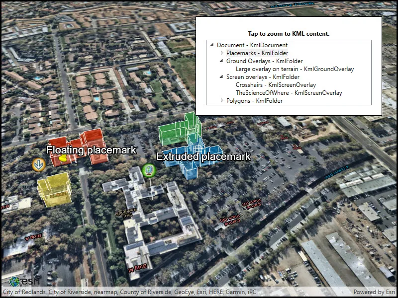
List the contents of a KML file.
Use case
KML files can contain a hierarchy of features, including network links to other KML content. A user may wish to traverse through the contents of KML nodes to know what data is contained within each node and, recursively, their children.
How to use the sample
The contents of the KML file are shown in a tree. Select a node to zoom to that node. Not all nodes can be zoomed to (e.g. screen overlays).
How it works
- Add the KML file to the scene as a layer.
- Explore the root nodes of the
KmlDatasetrecursively explored to create a view model.
- Each node is enabled for display at this step. KML files may include nodes that are turned off by default.
- When a node is selected, use the node’s
Extentto determine a viewpoint and set theSceneViewobject’s viewpoint do it.
Relevant API
- KmlContainer
- KmlDataset
- KmlDocument
- KmlFolder
- KmlGroundOverlay
- KmlLayer
- KmlNetworkLink
- KmlNode
- KmlPlacemark
- KmlScreenOverlay
About the data
This is an example KML file meant to demonstrate how Runtime supports several common features.
Tags
Keyhole, KML, KMZ, layers, OGC
Sample code
// Copyright 2018 Esri.//// Licensed under the Apache License, Version 2.0 (the "License"); you may not use this file except in compliance with the License.// You may obtain a copy of the License at: http://www.apache.org/licenses/LICENSE-2.0//// Unless required by applicable law or agreed to in writing, software distributed under the License is distributed on an// "AS IS" BASIS, WITHOUT WARRANTIES OR CONDITIONS OF ANY KIND, either express or implied. See the License for the specific// language governing permissions and limitations under the License.
using ArcGIS.Samples.Managers;using Esri.ArcGISRuntime.Geometry;using Esri.ArcGISRuntime.Mapping;using Esri.ArcGISRuntime.Ogc;using System;using System.Collections.Generic;using System.Collections.ObjectModel;using System.Threading.Tasks;using System.Windows;
namespace ArcGIS.WPF.Samples.ListKmlContents{    [ArcGIS.Samples.Shared.Attributes.Sample(        name: "List KML contents",        category: "Layers",        description: "List the contents of a KML file.",        instructions: "The contents of the KML file are shown in a tree. Select a node to zoom to that node. Not all nodes can be zoomed to (e.g. screen overlays).",        tags: new[] { "KML", "KMZ", "Keyhole", "OGC", "layers" })]    [ArcGIS.Samples.Shared.Attributes.OfflineData("b3ebedc3bed940fa985d824d55c44a2f")]    public partial class ListKmlContents    {        // Hold a list of LayerDisplayVM; this is the ViewModel.        private readonly ObservableCollection<LayerDisplayVM> _viewModelList = new ObservableCollection<LayerDisplayVM>();
        public ListKmlContents()        {            InitializeComponent();            _ = Initialize();        }
        private async Task Initialize()        {            // Add a basemap.            MySceneView.Scene = new Scene(BasemapStyle.ArcGISImagery);            MySceneView.Scene.BaseSurface.ElevationSources.Add(new ArcGISTiledElevationSource(new Uri("https://elevation3d.arcgis.com/arcgis/rest/services/WorldElevation3D/Terrain3D/ImageServer")));
            // Get the URL to the data.            Uri kmlUrl = new Uri(DataManager.GetDataFolder("b3ebedc3bed940fa985d824d55c44a2f", "esri_kml_sample_data.kmz"));
            // Create the KML dataset and layer.            KmlDataset dataset = new KmlDataset(kmlUrl);            KmlLayer layer = new KmlLayer(dataset);
            // Add the layer to the map.            MySceneView.Scene.OperationalLayers.Add(layer);
            try            {                await dataset.LoadAsync();
                // Build the ViewModel from the expanded list of layer infos.                foreach (KmlNode node in dataset.RootNodes)                {                    // LayerDisplayVM is a custom type made for this sample to serve as the ViewModel; it is not a part of ArcGIS Maps SDK for .NET.                    LayerDisplayVM nodeVm = new LayerDisplayVM(node, null);                    LayerDisplayVM.BuildNodeTree(nodeVm);                    _viewModelList.Add(nodeVm);                }
                // Update the list of layers, using the root node from the list.                LayerTreeView.ItemsSource = _viewModelList;            }            catch (Exception e)            {                MessageBox.Show(e.ToString(), "Error");            }        }
        private void LayerTreeView_OnSelectedItemChanged(object sender, RoutedPropertyChangedEventArgs<object> e)        {            // Get the KML node.            LayerDisplayVM selectedItem = (LayerDisplayVM)e.NewValue;
            _ = NavigateToNode(selectedItem.Node);        }
        #region viewpoint_conversion
        private async Task NavigateToNode(KmlNode node)        {            try            {                // Get a corrected Runtime viewpoint using the KmlViewpoint.                bool viewpointNeedsAltitudeAdjustment;                Viewpoint runtimeViewpoint = ViewpointFromKmlViewpoint(node, out viewpointNeedsAltitudeAdjustment);                if (viewpointNeedsAltitudeAdjustment)                {                    runtimeViewpoint = await GetAltitudeAdjustedViewpointAsync(node, runtimeViewpoint);                }
                // Set the viewpoint.                if (runtimeViewpoint != null && !runtimeViewpoint.TargetGeometry.IsEmpty)                {                    await MySceneView.SetViewpointAsync(runtimeViewpoint);                }            }            catch (Exception e)            {                MessageBox.Show(e.ToString(), "Error");            }        }
        private Viewpoint ViewpointFromKmlViewpoint(KmlNode node, out bool needsAltitudeFix)        {            KmlViewpoint kvp = node.Viewpoint;            // If KmlViewpoint is specified, use it.            if (kvp != null)            {                // Altitude adjustment is needed for everything except Absolute altitude mode.                needsAltitudeFix = (kvp.AltitudeMode != KmlAltitudeMode.Absolute);                switch (kvp.Type)                {                    case KmlViewpointType.LookAt:                        return new Viewpoint(kvp.Location,                            new Camera(kvp.Location, kvp.Range, kvp.Heading, kvp.Pitch, kvp.Roll));
                    case KmlViewpointType.Camera:                        return new Viewpoint(kvp.Location,                            new Camera(kvp.Location, kvp.Heading, kvp.Pitch, kvp.Roll));
                    default:                        throw new InvalidOperationException("Unexpected KmlViewPointType: " + kvp.Type);                }            }
            if (node.Extent != null && !node.Extent.IsEmpty)            {                // When no altitude specified, assume elevation should be taken into account.                needsAltitudeFix = true;
                // Workaround: it's possible for "IsEmpty" to be true but for width/height to still be zero.                if (node.Extent.Width == 0 && node.Extent.Height == 0)                {                    // Defaults based on Google Earth.                    return new Viewpoint(node.Extent, new Camera(node.Extent.GetCenter(), 1000, 0, 45, 0));                }                else                {                    Envelope tx = node.Extent;                    // Add padding on each side.                    double bufferDistance = Math.Max(node.Extent.Width, node.Extent.Height) / 20;                    Envelope bufferedExtent = new Envelope(                        tx.XMin - bufferDistance, tx.YMin - bufferDistance,                        tx.XMax + bufferDistance, tx.YMax + bufferDistance,                        tx.ZMin - bufferDistance, tx.ZMax + bufferDistance,                        SpatialReferences.Wgs84);                    return new Viewpoint(bufferedExtent);                }            }            else            {                // Can't fly to.                needsAltitudeFix = false;                return null;            }        }
        // Asynchronously adjust the given viewpoint, taking into consideration elevation and KML altitude mode.        private async Task<Viewpoint> GetAltitudeAdjustedViewpointAsync(KmlNode node, Viewpoint baseViewpoint)        {            // Get the altitude mode; assume clamp-to-ground if not specified.            KmlAltitudeMode altMode = KmlAltitudeMode.ClampToGround;            if (node.Viewpoint != null)            {                altMode = node.Viewpoint.AltitudeMode;            }
            // If the altitude mode is Absolute, the base viewpoint doesn't need adjustment.            if (altMode == KmlAltitudeMode.Absolute)            {                return baseViewpoint;            }
            double altitude;            Envelope lookAtExtent = baseViewpoint.TargetGeometry as Envelope;            MapPoint lookAtPoint = baseViewpoint.TargetGeometry as MapPoint;
            if (lookAtExtent != null)            {                // Get the altitude for the extent.                try                {                    altitude = await MySceneView.Scene.BaseSurface.GetElevationAsync(lookAtExtent.GetCenter());                }                catch (Exception)                {                    altitude = 0;                }
                // Apply elevation adjustment to the geometry.                Envelope target;                if (altMode == KmlAltitudeMode.ClampToGround)                {                    target = new Envelope(                        lookAtExtent.XMin, lookAtExtent.YMin,                        lookAtExtent.XMax, lookAtExtent.YMax,                        altitude, lookAtExtent.Depth + altitude,                        lookAtExtent.SpatialReference);                }                else                {                    target = new Envelope(                        lookAtExtent.XMin, lookAtExtent.YMin,                        lookAtExtent.XMax, lookAtExtent.YMax,                        lookAtExtent.ZMin + altitude, lookAtExtent.ZMax + altitude,                        lookAtExtent.SpatialReference);                }
                if (node.Viewpoint != null)                {                    // Return adjusted geometry with adjusted camera if a viewpoint was specified on the node.                    return new Viewpoint(target, baseViewpoint.Camera.Elevate(altitude));                }                else                {                    // Return adjusted geometry.                    return new Viewpoint(target);                }            }            else if (lookAtPoint != null)            {                // Get the altitude adjustment.                try                {                    altitude = await MySceneView.Scene.BaseSurface.GetElevationAsync(lookAtPoint);                }                catch (Exception)                {                    altitude = 0;                }
                // Apply elevation adjustment to the geometry.                MapPoint target;                if (altMode == KmlAltitudeMode.ClampToGround)                {                    target = new MapPoint(lookAtPoint.X, lookAtPoint.Y, altitude, lookAtPoint.SpatialReference);                }                else                {                    target = new MapPoint(                        lookAtPoint.X, lookAtPoint.Y, lookAtPoint.Z + altitude,                        lookAtPoint.SpatialReference);                }
                if (node.Viewpoint != null)                {                    // Return adjusted geometry with adjusted camera if a viewpoint was specified on the node.                    return new Viewpoint(target, baseViewpoint.Camera.Elevate(altitude));                }                else                {                    // Google Earth defaults: 1000m away and 45-degree tilt.                    return new Viewpoint(target, new Camera(target, 1000, 0, 45, 0));                }            }            else            {                throw new InvalidOperationException("KmlNode has unexpected Geometry for its Extent: " +                                                    baseViewpoint.TargetGeometry);            }        }
        #endregion viewpoint_conversion    }
    public class LayerDisplayVM    {        public KmlNode Node { get; set; }
        public List<LayerDisplayVM> Children { get; set; }
        private LayerDisplayVM Parent { get; set; }
        public LayerDisplayVM(KmlNode info, LayerDisplayVM parent)        {            Node = info;            Parent = parent;        }
        // Override ToString to enhance display formatting.        public override string ToString()        {            return Node.GetType().Name + " - " + Node.Name;        }
        public static void BuildNodeTree(LayerDisplayVM root)        {            // Make the node visible.            root.Node.IsVisible = true;
            // Initialize the child collection for the root.            root.Children = new List<LayerDisplayVM>();
            // Recursively add children. KmlContainers and KmlNetworkLinks can both have children.            var containerNode = root.Node as KmlContainer;            var networkLinkNode = root.Node as KmlNetworkLink;
            List<KmlNode> children = new List<KmlNode>();            if (containerNode != null)            {                children.AddRange(containerNode.ChildNodes);            }
            if (networkLinkNode != null)            {                children.AddRange(networkLinkNode.ChildNodes);            }
            foreach (KmlNode node in children)            {                // Create the view model for the sublayer.                LayerDisplayVM layerVm = new LayerDisplayVM(node, root);
                // Add the sublayer to the root's sublayer collection.                root.Children.Add(layerVm);
// Recursively add children. BuildNodeTree(layerVm); } } }}<UserControl x:Class="ArcGIS.WPF.Samples.ListKmlContents.ListKmlContents" xmlns="http://schemas.microsoft.com/winfx/2006/xaml/presentation" xmlns:x="http://schemas.microsoft.com/winfx/2006/xaml" xmlns:esri="http://schemas.esri.com/arcgis/runtime/2013" xmlns:listKmlContents="clr-namespace:ArcGIS.WPF.Samples.ListKmlContents"> <Grid> <esri:SceneView x:Name="MySceneView" /> <Border Style="{StaticResource BorderStyle}"> <Grid> <Grid.RowDefinitions> <RowDefinition Height="auto" /> <RowDefinition Height="*" /> </Grid.RowDefinitions> <TextBlock Grid.Row="0" Margin="5" FontWeight="Bold" Foreground="Black" Text="Tap to zoom to KML content." TextAlignment="Center" /> <TreeView Name="LayerTreeView" Grid.Row="1" FontSize="14" BorderBrush="Black" BorderThickness="1" ScrollViewer.HorizontalScrollBarVisibility="Auto" SelectedItemChanged="LayerTreeView_OnSelectedItemChanged"> <TreeView.ItemTemplate> <HierarchicalDataTemplate DataType="{x:Type listKmlContents:LayerDisplayVM}" ItemsSource="{Binding Children}"> <StackPanel Orientation="Horizontal"> <TextBlock Text="{Binding}" /> </StackPanel> </HierarchicalDataTemplate> </TreeView.ItemTemplate> </TreeView> </Grid> </Border> </Grid></UserControl>