These tools are used for data enrichment using geoanalytics
enrich_from_grid
-
arcgis.geoanalytics.data_enrichment.enrich_from_grid(input_layer, grid_layer, enrichment_attributes=None, output_name=None, gis=None, context=None, future=False)¶ 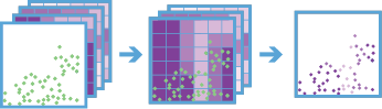
The Enrich From Multi-Variable Grid task joins attributes from a multivariable grid to a point layer. The multivariable grid must be created using the
build_multivariable_gridtask. Metadata from the multivariable grid is used to efficiently enrich the input point features, making it faster than the Join Features task. Attributes in the multivariable grid are joined to the input point features when the features intersect the grid.The attributes in the multivariable grid can be used as explanatory variables when modeling spatial relationships with your input point features, and this task allows you to join those attributes to the point features quickly.
Note
Only available at ArcGIS Enterprise 10.7 and later.
Parameter
Description
input_layer
Required layer. The point features that will be enriched by the multi-variable grid. See Feature Input.
grid_layer
Required layer. The multivariable grid layer created using the Build Multi-Variable Grid tool. See Feature Input.
enrichment_attributes
optional string. A list of fields in the multi-variable grid that will be joined to the input point features. If the attributes are not provided, all fields in the multi-variable grid will be joined to the input point features.
output_name
optional string. The task will create a feature service of the results. You define the name of the service.
gis
optional
GIS. The GIS object where the analysis will take place.context
Optional dict. The context parameter contains additional settings that affect task execution. For this task, there are five settings:
extent- A bounding box that defines the analysis area. Only those features that intersect the bounding box will be analyzed.outSR- The features will be projected into this coordinate system after the analysis to be saved. The output spatial reference for the spatiotemporal big data store is always WGS84.dataStore- Results will be saved to the specified data store. For ArcGIS Enterprise, the default is the spatiotemporal big data store.defaultAggregationStyles- If set to ‘True’, results will have square, hexagon, and triangle aggregation styles enabled on results map services.
future
optional boolean. If
True, a GPJob is returned instead of results. The GPJob can be queried on the status of the execution.The default value is
False.- Returns
# Usage Example: To enrich a layer of crime data with a multivariable grid containing demographic information.

enrich_result = enrich_from_grid(input_layer=crime_lyr,
                                 grid_layer=mvg_layer,
                                 output_name="chicago_crimes_enriched")
calculate_motion_statistics
-
arcgis.geoanalytics.data_enrichment.calculate_motion_statistics(input_layer, track_fields, motion_statistics='All', track_history_window=3, idle_tol_dist=None, idle_tol_unit=None, idle_time_tol=None, idle_time_tol_unit=None, time_boundary_split=None, split_unit=None, time_bound_ref=None, dist_method='Geodesic', distance_unit='Meters', duration_unit='Seconds', speed_unit='MetersPerSecond', accel_unit='MetersPerSecondSquared', elev_unit='meters', output_name=None, gis=None, context=None, future=False)¶ The Calculate Motion Statistics task calculates motion statistics and descriptors for time-enabled points that represent one or more moving entities. Points are grouped together into tracks representing each entity using a unique identifier. Motion statistics are calculated at each point using one or more points in the track history. Calculations include summaries of distance traveled, duration, elevation, speed, acceleration, bearing, and idle status. The result is a new point layer enriched with the requested statistics.
For example, a city is monitoring snowplow operations and wants to better understand vehicle movement. The Calculate Motion Statistics tool can be used to determine idle locations and time spent idling, average and maximum speeds over time, total distance covered, and other statistics.
Note
Only available at ArcGIS Enterprise 10.9 and later.
Parameter
Description
input_layer
Required layer. The time-enabled point features that will be grouped into tracks and analyzed. The input layer must be of time type instant. See Feature Input.
track_fields
Required String. The fields used to identify distinct tracks. There can be multiple trackFields in seperated by commas.
motion_statistics
Optional String. The type of motion statistics to calculated. The allowed values are:
distancespeedaccelerationdurationelevationslopeidlebearingall
allis the default.track_history_window
Optional Integer. The number of observations (including the current observation) that will be used when calculating summary statistics that are not instantaneous. This includes minimum, maximum, average, and total statistics. The default track history window is 3, which means that at each point in a track summary statistic will be calculated using the current observation and the previous three observations. This parameter does not affect instantaneous statistics or idle classification.
idle_tol_dist
Optional Float. Used along with
idle_time_tolto decide if an entity is idling. An entity is idling when it hasn’t moved more than this distance in at least the amount of time specified byidle_time_tol. The units of the time values are supplied by theidle_tol_unitparameter.This value is only used for statistics in the Idle group.
idle_tol_unit
Optional String. The unit of distance for idle distance tolerance.
idle_time_tol
Optional Float. The lead amount of time used to determine if someone is idling.
idle_time_tol_unit
Optional String. The time tolerance unit for idling.
time_boundary_split
Optional Float. A time boundary allows your to analyze values within a defined time span.
split_unit
Optional String. The unit of time represented in the
time_boundary_split.time_bound_ref
Optional Datetime. A date that specifies the reference time to align the time boundary to, represented in milliseconds from epoch.
dist_method
Optional String. The method used to calculate distances between track observations.
- There are two methods to choose from:
Planar- measures distances using an Euclidean plane and will not calculate statistics across the date line.Geodesic- calculations vary depending upon:If the spatial reference can be panned, calculations will cross the date line when appropriate
If the spatial reference cannot be panned, calculations will be limited to the coordinate system extent and may not wrap.
distance_unit
Optional String. The units for all results in the Distance motion statistics group.
- Options:
MetersKilometersFeetMilesNauticalMilesYards
Metersis the default.duration_unit
Optional String. The units for all results in the Duration motion statistics group.
- Options:
MillisecondsSecondsMinutesHoursDaysWeeksMonthsYears
Secondsis the default.speed_unit
Optional String. The units for all results in the Speed motion statistics group.
- Options:
MetersPerSecond(default)KilometersPerHourFeetPerSecondMilesPerHourNauticalMilesPerHour
MetersPerSecondis the default.accel_unit
Optional String. The units for all results in the Acceleration motion statistics group.
- Options:
MetersPerSecondSquaredFeetPerSecondSquared
MetersPerSecondSquaredis the default.elev_unit
Optional String. The units for all results in the Elevation motion statistics group.
- Options:
MetersKilometersFeetMilesNauticalMilesYards
Metersis the default.output_name
optional string. The task will create a feature service of the results. You define the name of the service.
gis
optional
GIS. The GIS object where the analysis will take place.context
Optional dict. The context parameter contains additional settings that affect task execution. For this task, there are five settings:
extent- A bounding box that defines the analysis area. Only those features that intersect the bounding box will be analyzed.processSR- The features will be projected into this coordinate system for analysis.outSR- The features will be projected into this coordinate system after the analysis to be saved. The output spatial reference for the spatiotemporal big data store is always WGS84.dataStore- Results will be saved to the specified data store. For ArcGIS Enterprise, the default is the spatiotemporal big data store.defaultAggregationStyles- If set to ‘True’, results will have square, hexagon, and triangle aggregation styles enabled on results map services.
future
optional boolean. If
True, a GPJob is returned instead of results. The GPJob can be queried on the status of the execution.The default value is
False.- Returns