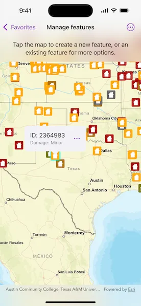
Create, update, and delete features to manage a feature layer.
Use case
An end-user performing a survey may want to manage features on the map in various ways during the course of their work.
How to use the sample
Pick an operation, then tap on the map to perform the operation at that location. Available feature management operations include: “Create feature”, “Delete feature”, “Update attribute”, and “Update geometry”.
How it works
- Create a
ServiceGeodatabasefrom a URL. - Get a
ServiceFeatureTablefrom theServiceGeodatabase. - Create a
FeatureLayerderived from theServiceFeatureTableinstance. - Apply the feature management operation upon selection.
- Create feature: create a
Featurewith attributes and a location using theServiceFeatureTable. - Delete feature: delete the selected
Featurefrom theFeatureTable. - Update attribute: update the attribute of the selected
Feature. - Update geometry: update the geometry of the selected
Feature.
- Update the
FeatureTablelocally. - Update the
ServiceGeodatabaseof theServiceFeatureTableby callingapplyEdits().
- This pushes the changes to the server.
Relevant API
- Feature
- FeatureLayer
- ServiceFeatureTable
- ServiceGeodatabase
Additional information
When editing feature tables that are subject to database behavior (operations on one table affecting another table), it’s now recommended to call these methods (apply or undo edits) on the ServiceGeodatabase object rather than on the ServiceFeatureTable object. Using the ServiceGeodatabase object to call these operations will prevent possible data inconsistencies and ensure transactional integrity so that all changes can be committed or rolled back.
Tags
amend, attribute, create, delete, deletion, details, edit, editing, feature, feature layer, feature table, geodatabase, information, moving, online service, service, update, updating, value
Sample code
// Copyright 2025 Esri//// Licensed under the Apache License, Version 2.0 (the "License");// you may not use this file except in compliance with the License.// You may obtain a copy of the License at////   https://www.apache.org/licenses/LICENSE-2.0//// Unless required by applicable law or agreed to in writing, software// distributed under the License is distributed on an "AS IS" BASIS,// WITHOUT WARRANTIES OR CONDITIONS OF ANY KIND, either express or implied.// See the License for the specific language governing permissions and// limitations under the License.
import ArcGISimport SwiftUI
struct ManageFeaturesView: View {    /// The data for the view.    @State private var data: Result<Data, any Error>?
    /// The result of the latest action.    @State private var status = ""
    /// The screen location that the user tapped.    @State private var tapLocation: CGPoint?
    /// The map location that the user tapped.    @State private var tapMapPoint: Point?
    /// The placement of the callout.    @State private var calloutPlacement: CalloutPlacement?
    /// The current viewpoint of the map view.    @State private var currentViewpoint: Viewpoint?
    /// A Boolean value indicating whether the update attribute dialog is displayed.    @State private var isShowingUpdateAttributeDialog = false
    var body: some View {        Group {            switch data {            case .success(let data):                // Show map view if data loads.                mapView(data)            case .failure:                // Show content unavailable if data does not load.                ContentUnavailableView(                    "Error",                    systemImage: "exclamationmark.triangle",                    description: Text("Failed to load sample data.")                )            case .none:                // Show progress view during loading.                ProgressView()            }        }        .animation(.default, value: status)        .animation(.default, value: calloutPlacement)        .task { await loadData() }    }
    @ViewBuilder    func mapView(_ data: Data) -> some View {        MapViewReader { mapView in            MapView(map: data.map)                .onSingleTapGesture { tapLocation, tapMapPoint in                    if calloutPlacement == nil {                        self.tapLocation = tapLocation                        self.tapMapPoint = tapMapPoint                    } else {                        clearSelection()                    }                }                .callout(placement: $calloutPlacement) { placement in                    if let feature = placement.geoElement as? Feature {                        featureCalloutContent(feature: feature, table: data.featureTable)                    } else if let tapMapPoint {                        addNewFeatureCalloutContent(table: data.featureTable, point: tapMapPoint)                    }                }                .onNavigatingChanged { _ in                    // Reset status when user moves the map.                    clearStatus()                }                .onViewpointChanged(kind: .centerAndScale) { viewpoint in                    // Track current viewpoint.                    currentViewpoint = viewpoint                }                .overlay(alignment: .top) {                    instructionsOverlay                }                .task(id: tapLocation) {                    // Identify when we get a tap location.                    guard let tapLocation, let tapMapPoint else { return }                    if let identifyResult = try? await mapView.identify(on: data.featureLayer, screenPoint: tapLocation, tolerance: 12),                       let geoElement = identifyResult.geoElements.first,                       let feature = geoElement as? Feature {                        // Place a callout for a feature.                        calloutPlacement = .geoElement(geoElement)                        data.featureLayer.selectFeature(feature)                    } else {                        // Place a callout for adding a new feature.                        calloutPlacement = .location(tapMapPoint)                    }                }        }    }
    /// A callout that allows the user to add a new feature.    @ViewBuilder    func addNewFeatureCalloutContent(table: ServiceFeatureTable, point: Point) -> some View {        Button("Create Feature", systemImage: "plus.circle") {            clearSelection()            Task {                await createFeature(point: point)            }        }        .padding()    }
    /// A callout that allows a user to modify or delete an existing feature.    @ViewBuilder    func featureCalloutContent(feature: Feature, table: ServiceFeatureTable) -> some View {        HStack {            VStack(alignment: .leading) {                Text("ID: \(feature.attributeValue(forKey: table.objectIDField) as? String ?? "Unknown")")                Text("Damage: \(feature.damageKind?.rawValue ?? "Unknown")")                    .font(.footnote)                    .foregroundStyle(.secondary)            }            Menu {                Button("Update Attribute") {                    isShowingUpdateAttributeDialog = true                }                Button("Update Geometry") {                    // Hide callout, leave feature selected.                    calloutPlacement = nil                    Task {                        await updateGeometry(                            for: feature,                            geometry: currentViewpoint?.targetGeometry                        )                        // Update callout location after moving feature.                        calloutPlacement = .geoElement(feature)                    }                }                Button("Delete Feature") {                    Task {                        clearSelection()                        await delete(feature: feature)                    }                }            } label: {                Label("Edit Feature", systemImage: "ellipsis")                    .padding()                    .contentShape(.rect)                    .labelStyle(.iconOnly)            }            .fixedSize()            .confirmationDialog("Update Attribute", isPresented: $isShowingUpdateAttributeDialog) {                ForEach(DamageKind.allCases, id: \.self) { damageKind in                    Button(damageKind.rawValue) {                        isShowingUpdateAttributeDialog = false                        clearSelection()
                        Task {                            await updateAttribute(for: feature, damageKind: damageKind)                        }                    }                }            } message: {                Text("Choose a damage kind for the feature.")            }        }        .padding([.leading, .vertical])    }
    /// Overlay with instructions for the user.    @ViewBuilder var instructionsOverlay: some View {        VStack(spacing: 8) {            Text("Tap the map to create a new feature, or tap an existing feature for more options.")                .multilineTextAlignment(.center)            if !status.isEmpty {                Text(status)                    .font(.footnote)                    .foregroundStyle(.secondary)                    .multilineTextAlignment(.center)            }        }        .padding()        .frame(maxWidth: .infinity)        .background(.ultraThinMaterial)    }
    /// Clears the selection on the feature layer, hides the callout, and    /// resets the status.    func clearSelection() {        if case .success(let data) = data {            data.featureLayer.clearSelection()        }        calloutPlacement = nil        clearStatus()    }
    /// Clear the status.    func clearStatus() {        status = ""    }}
extension ManageFeaturesView {    /// Loads the data for this view.    func loadData() async {        let map = Map(basemapStyle: .arcGISStreets)        map.initialViewpoint = Viewpoint(            center: Point(x: -10_800_000, y: 4_500_000, spatialReference: .webMercator),            scale: 3e7        )
        let geodatabase = ServiceGeodatabase(            url: URL(string: "https://sampleserver6.arcgisonline.com/arcgis/rest/services/DamageAssessment/FeatureServer/0")!        )
        do {            try await geodatabase.load()            let featureTable = geodatabase.table(withLayerID: 0)!            let layer = FeatureLayer(featureTable: featureTable)            map.addOperationalLayer(layer)            data = .success(                Data(map: map, geodatabase: geodatabase, featureTable: featureTable, featureLayer: layer)            )        } catch {            data = .failure(error)        }    }
    /// Creates a new feature at a specified location and applies edits to the service.    /// - Parameters:    ///   - point: The geometry for the feature you are creating.    func createFeature(point: Point) async {        guard case .success(let data) = data else { return }        let table = data.featureTable
        let feature = table.makeFeature(            attributes: [                Feature.damageTypeFieldName: DamageKind.inaccessible.rawValue,                "primcause": "Earthquake"            ],            geometry: point        )        do {            try await table.add(feature)            _ = try await table.serviceGeodatabase?.applyEdits()            status = "Create feature succeeded."        } catch {            status = "Error creating feature."        }    }
    /// Updates the attributes of a feature and applies edits to the service.    /// - Parameters:    ///   - feature: The feature to update.    ///   - damageKind: The kind used to set the feature's damage assessment attribute.    func updateAttribute(for feature: Feature, damageKind: DamageKind) async {        guard case .success(let data) = data else { return }        let table = data.featureTable
        do {            feature.damageKind = damageKind            try await table.update(feature)            _ = try await table.serviceGeodatabase?.applyEdits()            status = "Update attribute succeeded."        } catch {            status = "Error updating attribute."        }    }
    /// Updates the geometry of a feature and applies edits to the service.    /// This moves the feature to the center of the map.    /// - Parameters:    ///   - feature: The feature to update.    ///   - geometry: The new geometry.    func updateGeometry(for feature: Feature, geometry: Geometry?) async {        guard case .success(let data) = data else { return }        let table = data.featureTable
        do {            feature.geometry = geometry            try await table.update(feature)            _ = try await table.serviceGeodatabase?.applyEdits()            status = "Update geometry succeeded."        } catch {            status = "Error updating geometry."        }    }
    /// Deletes a feature from the table and applies edits to the service.    /// - Parameter feature: The feature to delete.    func delete(feature: Feature) async {        guard case .success(let data) = data else { return }        let table = data.featureTable
        do {            try await table.delete(feature)            _ = try await table.serviceGeodatabase?.applyEdits()            status = "Delete feature succeeded."        } catch {            status = "Error deleting feature."        }    }}
extension ManageFeaturesView {    /// Data value for the sample.    struct Data {        /// The map that will be displayed.        let map: Map        /// The service geodatabase.        let geodatabase: ServiceGeodatabase        /// The service feature table.        let featureTable: ServiceFeatureTable        /// The feature layer.        let featureLayer: FeatureLayer    }}
extension ManageFeaturesView {    /// A value that describes the damage assessment value for a feature.    enum DamageKind: String, CaseIterable {        case inaccessible = "Inaccessible"        case affected = "Affected"        case minor = "Minor"        case major = "Major"        case destroyed = "Destroyed"    }}
extension Feature {    /// The name of the damage type field.    static let damageTypeFieldName = "typdamage"
    /// The damage assessment of the feature.    var damageKind: ManageFeaturesView.DamageKind? {        get {            // Return the attribute value as a DamageKind.            ManageFeaturesView.DamageKind(                rawValue: attributeValue(forKey: Self.damageTypeFieldName) as? String ?? ""            )        } set {            // Set the attribute value on the feature by converting the            // DamageKind to a String value.            setAttributeValue(newValue?.rawValue, forKey: Self.damageTypeFieldName)        }    }}