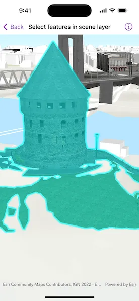
Identify features in a scene to select.
Use case
You can select features to visually distinguish them with a selection color or highlighting. This can be useful to demonstrate the physical extent or associated attributes of a feature, or to initiate another action such as centering that feature in the scene view.
How to use the sample
Tap on a building in the scene layer to select it. Deselect buildings by tapping away from the buildings.
How it works
- Create an instance of
ArcGISSceneLayer, passing in the URL to a scene layer service. - Use the
onSingleTapGestureon theSceneViewto get the screen tapped location. - Use
SceneViewProxy.identify(layer:screenPoint:tolerance:maximumResults:)to identify features in the scene. - From the resulting
IdentifyLayerResult, get the list of identifiedGeoElements. - Get the first
Featurein the list and useArcGISSceneLayer.selectFeature(features:).
Relevant API
- ArcGISSceneLayer
- Scene
- SceneView
- SceneViewProxy
- SceneViewReader
About the data
This sample shows a Brest France Buildings Scene hosted on ArcGIS Online.
Tags
3D, buildings, identify, model, query, search, select
Sample code
SelectFeaturesInSceneLayerView.swift
// Copyright 2024 Esri//// Licensed under the Apache License, Version 2.0 (the "License");// you may not use this file except in compliance with the License.// You may obtain a copy of the License at////   https://www.apache.org/licenses/LICENSE-2.0//// Unless required by applicable law or agreed to in writing, software// distributed under the License is distributed on an "AS IS" BASIS,// WITHOUT WARRANTIES OR CONDITIONS OF ANY KIND, either express or implied.// See the License for the specific language governing permissions and// limitations under the License.
import ArcGISimport SwiftUI
struct SelectFeaturesInSceneLayerView: View {    /// The error shown in the error alert.    @State private var error: (any Error)?
    /// The point on the screen where the user tapped.    @State private var tapPoint: CGPoint?
    /// The scene layer that is added on top of the scene.    @State private var sceneLayer = ArcGISSceneLayer(url: .brestBuildingService)
    /// A scene with topographic basemap and a 3D buildings layer.    @State private var scene: ArcGIS.Scene = {        // Creates a scene and sets an initial viewpoint.        let scene = Scene(basemapStyle: .arcGISTopographic)        // Sets an initial camera location.        let camera = Camera(            latitude: 48.38282,            longitude: -4.49779,            altitude: 40,            heading: 41.65,            pitch: 71.2,            roll: 0        )        // Sets initial viewpoint to camera position at point.        scene.initialViewpoint = Viewpoint(boundingGeometry: camera.location, camera: camera)        // Creates a surface and adds an elevation source.        let surface = Surface()        surface.addElevationSource(ArcGISTiledElevationSource(url: .worldElevationService))        // Sets the surface to the scene's base surface.        scene.baseSurface = surface        return scene    }()
    /// Adds feature layer to scene in initialization.    init() {        scene.addOperationalLayer(sceneLayer)    }
    var body: some View {        SceneViewReader { sceneViewProxy in            SceneView(scene: scene)            // Captures location of tap on screen.                .onSingleTapGesture { screenPoint, _ in                    tapPoint = screenPoint                }                .task(id: tapPoint) {                    // Clears the previous selections.                    sceneLayer.clearSelection()                    do {                        guard let locationPoint = tapPoint else { return }                        // Gets the identify results from the tap point.                        let result = try await sceneViewProxy.identify(                            on: sceneLayer,                            screenPoint: locationPoint,                            tolerance: 10                        )                        // Gets the first feature from the identify results.                        guard let feature = result.geoElements.first as? ArcGISFeature else { return }                        // Selects the feature in the scene layer.                        sceneLayer.selectFeature(feature)                    } catch {                        self.error = error                    }                }        }        .errorAlert(presentingError: $error)    }}
private extension URL {    /// The URL of a Brest, France buildings scene service.    static var brestBuildingService: URL {        URL(string: "https://tiles.arcgis.com/tiles/P3ePLMYs2RVChkJx/arcgis/rest/services/Buildings_Brest/SceneServer/layers/0")!    }
    /// The URL of the Terrain 3D ArcGIS REST Service.    static var worldElevationService: URL {        URL(string: "https://elevation3d.arcgis.com/arcgis/rest/services/WorldElevation3D/Terrain3D/ImageServer")!    }}
#Preview {    SelectFeaturesInSceneLayerView()}