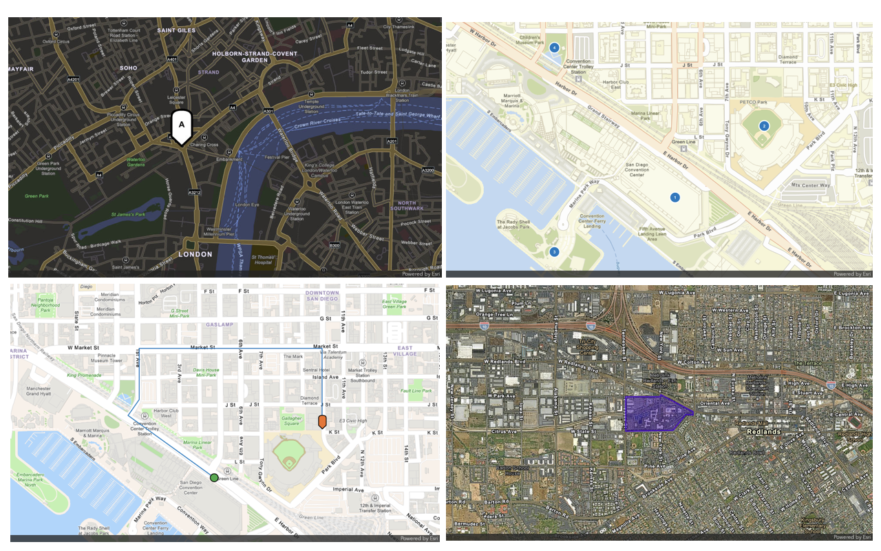
Learn how to use the ArcGIS Static Maps servicePOST request.
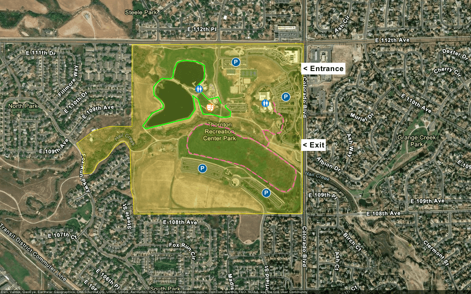
In this tutorial, you use the /with-overlay endpoint from the ArcGIS Static Maps service to generate a complex static map with multiple geometries. You also learn how to customize geometries with SVG markers, labels, and colors, and add text labels for the park entrance and exit. The resulting static map is a visitor guide for a local community center, showing parking areas, restrooms, an amphitheatre, and entrance/exit areas. Trails are represented by polylines, and the community center boundary is represented by a polygon.
Prerequisites
You need an ArcGIS Location Platform account to get an access token
Steps
Get an access token
Create a new API key credential
-
If you are familiar with API keys, create an API key credential with the following configurations:
- Type of application: Public application
- Required privileges: Location services > Static maps
If you are new to API keys, go to the Create an API key tutorial for full step-by-step instructions.
-
When prompted, copy and paste the API key to a safe location. It will be used in the next step.
Create the request body
-
Define the
/with-overlayendpoint and set the basemap style toarcgis/imagery. The URL should look like this:Use dark colors for code blocks Copy https://static-maps-api.arcgis.com/arcgis/rest/services/static-maps-service/v1/static-maps/arcgis/imagery/with-overlay -
Configure the
POSTrequest by setting theAuthorizationheader toBearer <YOUR, replacing_ACCESS _TOKEN > <YOURwith your access token, and defining the following request body:_ACCESS _TOKEN > - Define the
imageobject:- Set
widthto700. - Set
heightto300. - Set
formattopng.
- Set
- Define the
mapobject:- Set
center.xto-104.944. - Set
center.yto39.895.
- Set
- Define the
-
The request should look like this:
Use dark colors for code blocks Copy POST https://static-maps-api.arcgis.com/arcgis/rest/services/static-maps-service/v1/static-maps/arcgis/imagery/with-overlay HTTP/1.1 Host: static-maps-api.arcgis.com Content-Type: application/json Authorization: Bearer YOUR_ACCESS_TOKEN Accept: image/png { "image": { "width": 700, "height": 300, "format": "png" }, "map": { "zoom": 15, "center": { "x": -104.944, "y": 39.895 } } }
Create a polygon
The overlay array in the request body is used to define geometries on the static map. Create a polygon to represent the community center boundary.
-
In the request body, define the
overlayarray and add a polygon for the community center boundary.- Set the
typetopolygon. - Set the
geometry.ringsto[[[-104.9402957, 39.8993397], [-104.9496416, 39.8992878], [-104.9496416, 39.895869], [-104.9508878, 39.895869], [-104.9517411, 39.8956819], [-104.9526892, 39.8951416], [-104.9522693, 39.8946116], [-104.9522693, 39.8943206], [-104.9523235, 39.8938737], [-104.9518494, 39.8939049], [-104.9516598, 39.894092], [-104.9514973, 39.8943414], [-104.9509284, 39.8946324], [-104.9507388, 39.8948922], [-104.9502918, 39.8951727], [-104.950048, 39.8952247], [-104.9497635, 39.8949233], [-104.9497094, 39.8931983], [-104.9495739, 39.8928449], [-104.9495468, 39.8921902], [-104.9403462, 39.8921958], [-104.9402957, 39.8993397]]]. - Set the
geometry.spatialtoReference.wkid 4326. - Set the
symbol.styletosolid. - Set the
symbol.colortofcef033b. - Set the
symbol.outline.styletosolid. - Set the
symbol.outline.colortofcef03. - Set the
symbol.outline.widthto1.
Use dark colors for code blocks Copy "overlay": [ { "type": "polygon", "geometry": { "rings": [[[-104.9402957, 39.8993397], [-104.9496416, 39.8992878], [-104.9496416, 39.895869], [-104.9508878, 39.895869], [-104.9517411, 39.8956819], [-104.9526892, 39.8951416], [-104.9522693, 39.8946116], [-104.9522693, 39.8943206], [-104.9523235, 39.8938737], [-104.9518494, 39.8939049], [-104.9516598, 39.894092], [-104.9514973, 39.8943414], [-104.9509284, 39.8946324], [-104.9507388, 39.8948922], [-104.9502918, 39.8951727], [-104.950048, 39.8952247], [-104.9497635, 39.8949233], [-104.9497094, 39.8931983], [-104.9495739, 39.8928449], [-104.9495468, 39.8921902], [-104.9403462, 39.8921958], [-104.9402957, 39.8993397]]], "spatialReference": { "wkid": 4326 } }, "symbol": { "style": "solid", "color": "fcef033b", "outline": { "style": "solid", "color": "fcef03", "width": 1 } } } ] - Set the
Create points with default marker symbols
In the overlay array, create points with default marker symbols and labels to represent parking areas.
-
In the
overlayarray, create four new geometries with default marker symbols and labels.- Set the
typetopoint - Set the
geometry.xto-104.9458346andgeometry.yto39.8941225. - Set the
geometry.spatialtoReference.wkid 4326. - Set the
symbol.styletocircle. - Set the
symbol.colorto005e95. - Set the
symbol.labeltoP. - Set the
symbol.scaleto1.
- Set the
-
Repeat the previous step for three more points, changing the
geometry.xandgeometry.yvalues for each point.geometry.xto-104.9423264andgeometry.yto39.8930833.geometry.xto-104.9412564andgeometry.yto39.8971153.geometry.xto-104.944006andgeometry.yto39.8985702.
-
Your
overlayarray should now look like this:Use dark colors for code blocks Copy "overlay": [ // ... existing polygon geometry { "type": "point", "geometry": { "x": -104.9458346, "y": 39.8941225, "spatialReference": { "wkid": 4326 } }, "symbol": { "style": "circle", "color": "005e95", "label": "P", "scale": 1 } }, { "type": "point", "geometry": { "x": -104.9423264, "y": 39.8930833, "spatialReference": { "wkid": 4326 } }, "symbol": { "style": "circle", "color": "005e95", "label": "P", "scale": 1 } }, { "type": "point", "geometry": { "x": -104.9412564, "y": 39.8971153, "spatialReference": { "wkid": 4326 } }, "symbol": { "style": "circle", "color": "005e95", "label": "P", "scale": 1 } }, { "type": "point", "geometry": { "x": -104.944006, "y": 39.8985702, "spatialReference": { "wkid": 4326 } }, "symbol": { "style": "circle", "color": "005e95", "label": "P", "scale": 1 } } ]
Create points with custom marker symbols
In the overlay array, create points with custom marker symbols to represent places of interest, such as restrooms and an amphitheatre, within the community center. The custom marker symbols are defined in the symbol object in the request body as key-value pairs. The key is a unique string and the value is a base64‑encoded data URL string representing the SVG image. The symbols are then referenced in the point geometries using custom.
-
Create a
symbolobject in the request body and define two custom marker symbols for the restrooms and amphitheatre.Dictionary - Set the
restroomkey to:Use dark colors for code blocks Copy data:image/svg+xml;base64,PHN2ZyB4bWxucz0iaHR0cDovL3d3dy53My5vcmcvMjAwMC9zdmciIHZpZXdCb3g9IjAgMCAxNyAxNyI+CiAgPGNpcmNsZSBjeD0iOC41IiBjeT0iOC41IiByPSI4LjUiIGZpbGw9IiNGMjhDMjgiLz4KICA8cGF0aCBmaWxsPSIjZmZmZmZmIiBkPSJNMTQuNTggMi45OThzLTEuNDkyIDEuMS0zLjU4IDEuMWMtLjA0IDAtLjA3NC0uMDA2LS4xMTMtLjAwNy4wMzUuNDQ5LjA1OC45NDYuMDU4IDEuNDc3IDAgMS44OC0uMjk4IDQuMDQtLjM2MiA0LjQ4LjEzOC0uMDIuMjY5LS4wNS40MTctLjA1IDIgMCAzIDIgMyAycy0xLjM3NS0xLjEtMy0xLjFjLS4yMDYgMC0uNDA4LjAxOC0uNjAzLjA0OS0uMjY4Ljk3My0uOCAyLjE0LTEuNjg4IDIuOTcxLjUzMy42MTIgMS4yNyAxLjA4IDIuMjkxIDEuMDggMyAwIDMuNTgtNCAzLjU4LTRzLjM2NS0yLjQyMi4zNjUtNC40M2MwLTIuMDUtLjM2NS0zLjU3LS4zNjUtMy41N3ptLTEuMDggNGgtMWEuNTAxLjUwMSAwIDAgMS0uNS0uNWMwLS4yNzUuMjI1LS41LjUtLjVoMWMuMjc1IDAgLjUuMjI1LjUuNXMtLjIyNS41LS41LjV6bS0zLjkyLTVzLTEuNDkyIDEuMS0zLjU4IDEuMS0zLjU4LTEuMS0zLjU4LTEuMS0uMzY1IDEuNTE1LS4zNjUgMy41Ny4zNjUgNC40My4zNjUgNC40My41OCA0IDMuNTggNCAzLjU4LTQgMy41OC00IC4zNjUtMi40MjIuMzY1LTQuNDNjMC0yLjA1LS4zNjUtMy41Ny0uMzY1LTMuNTd6bS02LjA4IDNoMWMuMjc1IDAgLjUuMjI1LjUuNXMtLjIyNS41LS41LjVoLTFhLjUwMS41MDEgMCAwIDEtLjUtLjVjMC0uMjc1LjIyNS0uNS41LS41em0yLjUgNmMtMiAwLTMtMi0zLTJzMS4zNzUgMS4xIDMgMS4xIDMtMS4xIDMtMS4xLTEgMi0zIDJ6bTIuNS01aC0xYS41MDEuNTAxIDAgMCAxLS41LS41YzAtLjI3NS4yMjUtLjUuNS0uNWgxYy4yNzUgMCAuNS4yMjUuNS41cy0uMjI1LjUtLjUuNXoiLz4KPC9zdmc+ - Set the
amphitheatrekey to:Use dark colors for code blocks Copy data:image/svg+xml;base64,PHN2ZyB4bWxucz0iaHR0cDovL3d3dy53My5vcmcvMjAwMC9zdmciIHZpZXdCb3g9IjAgMCAyMSAyMSI+CiAgPGNpcmNsZSBjeD0iMTAuNSIgY3k9IjEwLjUiIHI9IjEwLjUiIGZpbGw9IiMwMDc4RDQiLz4KICA8cGF0aCBmaWxsPSIjZmZmIiBkPSJNNi4xNSA0YTEuMzUgMS4zNSAwIDEgMSAyLjcgMCAxLjM1IDEuMzUgMCAwIDEtMi43IDB6bTguMzUgMS4zNWExLjM1IDEuMzUgMCAxIDAgMC0yLjcgMS4zNSAxLjM1IDAgMCAwIDAgMi43em0tNC4yMiAxLjQ1MmExLjAzNyAxLjAzNyAwIDAgMC0uOTgtLjgwNGwtMy42MDguMDAxYy0uNDg1LjAwNC0uODg5LjM4OC0uOTcyLjgwM2wtLjU2NCAyLjgxN2MtLjA5Mi40NTktLjE5Ni45MTUtLjI4OCAxLjM3My0uMTMuNjQzLS4yNTUgMS41MzguMzk5IDEuNDkyYS40NDguNDQ4IDAgMCAwIC40MDgtLjM1OWwuODUtNC4yNS42NzQgMS4xMjMtLjk5OSA2SDZ2My41YS41LjUgMCAxIDAgMSAwdi0zLjVoMXYzLjVhLjUuNSAwIDEgMCAxIDB2LTMuNWguOGwtLjk5OS02IC42NzctMS4xMTIuODQ3IDQuMjRjLjA0LjE5Ny4yMDcuMzQ0LjQwOC4zNTguNzgzLjA1NC40NTItMS4xNTguMzAzLTEuOTA1bC0uNDA3LTIuMDM0LS4zNDktMS43NDN6TTE2IDUuOTk4aC0zYy0uNTUgMC0xIC40NS0xIDF2NS41YS41LjUgMCAwIDAgLjUuNWguNXY1LjVhLjUuNSAwIDEgMCAxIDB2LTQuNWgxdjQuNWEuNS41IDAgMSAwIDEgMHYtNS41aC41YS41LjUgMCAwIDAgLjUtLjV2LTUuNWMwLS41NS0uNDUtMS0xLTF6Ii8+Cjwvc3ZnPgo=
- Set the
-
In the
overlayarray, create a new point with a custom marker symbol for the amphitheatre.- Set the
typetopoint - Set the
geometry.xto-104.945388andgeometry.yto39.8966582. - Set the
geometry.spatialtoReference.wkid 4326. - Set the
symbol.customtoSymbol Id amphitheatre. - Set the
symbol.scaleto1.
- Set the
-
Create a new point with a custom marker symbol for the restroom.
- Set the
typetopoint - Set the
geometry.xto-104.9459995andgeometry.yto39.8974496. - Set the
geometry.spatialtoReference.wkid 4326. - Set the
symbol.customtoSymbol Id restroom. - Set the
symbol.scaleto0.75.
- Set the
-
Create another point with a custom marker symbol for the restroom, with
geometry.xof-104.9423995andgeometry.yof39.8968409. -
Your
overlayarray should now include all the points with their respective custom marker symbols.Use dark colors for code blocks Copy { "overlay": [ // ... existing polygon geometry // ... existing points geometry { "type": "point", "geometry": { "x": -104.945388, "y": 39.8966582, "spatialReference": { "wkid": 4326 } }, "symbol": { "customSymbolId": "amphitheatre", "scale": 1 } }, { "type": "point", "geometry": { "x": -104.9459995, "y": 39.8974496, "spatialReference": { "wkid": 4326 } }, "symbol": { "customSymbolId": "bathroom", "scale": 0.75 } }, { "type": "point", "geometry": { "x": -104.9423995, "y": 39.8968409, "spatialReference": { "wkid": 4326 } }, "symbol": { "customSymbolId": "bathroom", "scale": 0.75 } }, ], "symbolDictionary": { "amphitheatre": "data:image/svg+xml;base64,PHN2ZyB4bWxucz0iaHR0cDovL3d3dy53My5vcmcvMjAwMC9zdmciIHZpZXdCb3g9IjAgMCAxNyAxNyI+CiAgPGNpcmNsZSBjeD0iOC41IiBjeT0iOC41IiByPSI4LjUiIGZpbGw9IiNGMjhDMjgiLz4KICA8cGF0aCBmaWxsPSIjZmZmZmZmIiBkPSJNMTQuNTggMi45OThzLTEuNDkyIDEuMS0zLjU4IDEuMWMtLjA0IDAtLjA3NC0uMDA2LS4xMTMtLjAwNy4wMzUuNDQ5LjA1OC45NDYuMDU4IDEuNDc3IDAgMS44OC0uMjk4IDQuMDQtLjM2MiA0LjQ4LjEzOC0uMDIuMjY5LS4wNS40MTctLjA1IDIgMCAzIDIgMyAycy0xLjM3NS0xLjEtMy0xLjFjLS4yMDYgMC0uNDA4LjAxOC0uNjAzLjA0OS0uMjY4Ljk3My0uOCAyLjE0LTEuNjg4IDIuOTcxLjUzMy42MTIgMS4yNyAxLjA4IDIuMjkxIDEuMDggMyAwIDMuNTgtNCAzLjU4LTRzLjM2NS0yLjQyMi4zNjUtNC40M2MwLTIuMDUtLjM2NS0zLjU3LS4zNjUtMy41N3ptLTEuMDggNGgtMWEuNTAxLjUwMSAwIDAgMS0uNS0uNWMwLS4yNzUuMjI1LS41LjUtLjVoMWMuMjc1IDAgLjUuMjI1LjUuNXMtLjIyNS41LS41LjV6bS0zLjkyLTVzLTEuNDkyIDEuMS0zLjU4IDEuMS0zLjU4LTEuMS0zLjU4LTEuMS0uMzY1IDEuNTE1LS4zNjUgMy41Ny4zNjUgNC40My4zNjUgNC40My41OCA0IDMuNTggNCAzLjU4LTQgMy41OC00IC4zNjUtMi40MjIuMzY1LTQuNDNjMC0yLjA1LS4zNjUtMy41Ny0uMzY1LTMuNTd6bS02LjA4IDNoMWMuMjc1IDAgLjUuMjI1LjUuNXMtLjIyNS41LS41LjVoLTFhLjUwMS41MDEgMCAwIDEtLjUtLjVjMC0uMjc1LjIyNS0uNS41LS41em0yLjUgNmMtMiAwLTMtMi0zLTJzMS4zNzUgMS4xIDMgMS4xIDMtMS4xIDMtMS4xLTEgMi0zIDJ6bTIuNS01aC0xYS41MDEuNTAxIDAgMCAxLS41LS41YzAtLjI3NS4yMjUtLjUuNS0uNWgxYy4yNzUgMCAuNS4yMjUuNS41cy0uMjI1LjUtLjUuNXoiLz4KPC9zdmc+", "bathroom": "data:image/svg+xml;base64,PHN2ZyB4bWxucz0iaHR0cDovL3d3dy53My5vcmcvMjAwMC9zdmciIHZpZXdCb3g9IjAgMCAyMSAyMSI+CiAgPGNpcmNsZSBjeD0iMTAuNSIgY3k9IjEwLjUiIHI9IjEwLjUiIGZpbGw9IiMwMDc4RDQiLz4KICA8cGF0aCBmaWxsPSIjZmZmIiBkPSJNNi4xNSA0YTEuMzUgMS4zNSAwIDEgMSAyLjcgMCAxLjM1IDEuMzUgMCAwIDEtMi43IDB6bTguMzUgMS4zNWExLjM1IDEuMzUgMCAxIDAgMC0yLjcgMS4zNSAxLjM1IDAgMCAwIDAgMi43em0tNC4yMiAxLjQ1MmExLjAzNyAxLjAzNyAwIDAgMC0uOTgtLjgwNGwtMy42MDguMDAxYy0uNDg1LjAwNC0uODg5LjM4OC0uOTcyLjgwM2wtLjU2NCAyLjgxN2MtLjA5Mi40NTktLjE5Ni45MTUtLjI4OCAxLjM3My0uMTMuNjQzLS4yNTUgMS41MzguMzk5IDEuNDkyYS40NDguNDQ4IDAgMCAwIC40MDgtLjM1OWwuODUtNC4yNS42NzQgMS4xMjMtLjk5OSA2SDZ2My41YS41LjUgMCAxIDAgMSAwdi0zLjVoMXYzLjVhLjUuNSAwIDEgMCAxIDB2LTMuNWguOGwtLjk5OS02IC42NzctMS4xMTIuODQ3IDQuMjRjLjA0LjE5Ny4yMDcuMzQ0LjQwOC4zNTguNzgzLjA1NC40NTItMS4xNTguMzAzLTEuOTA1bC0uNDA3LTIuMDM0LS4zNDktMS43NDN6TTE2IDUuOTk4aC0zYy0uNTUgMC0xIC40NS0xIDF2NS41YS41LjUgMCAwIDAgLjUuNWguNXY1LjVhLjUuNSAwIDEgMCAxIDB2LTQuNWgxdjQuNWEuNS41IDAgMSAwIDEgMHYtNS41aC41YS41LjUgMCAwIDAgLjUtLjV2LTUuNWMwLS41NS0uNDUtMS0xLTF6Ii8+Cjwvc3ZnPgo=" } }
Create polylines
In the overlay array, create polylines to represent trails around the community center. The polylines can be styled with different colors, line symbols, and widths to indicate the type of trail.
-
In the
overlayarray, create a new polyline that represents a biking trail with solid lines.- Set the
typetopolyline. - Set the
geometry.pathsto[[[-104.9445212, 39.8967743], [-104.944576, 39.8966819], [-104.9442692, 39.8964801], [-104.9442911, 39.8962699], [-104.9445103, 39.8962447], [-104.944828, 39.8962531], [-104.9452882, 39.8963876], [-104.9457813, 39.8963876], [-104.9458799, 39.8966062], [-104.9460443, 39.8969929], [-104.9463292, 39.897161], [-104.9461977, 39.8965894], [-104.9465264, 39.8962195], [-104.9488932, 39.8957571], [-104.9490685, 39.8958916], [-104.9485426, 39.8964128], [-104.9479618, 39.8966146], [-104.9479399, 39.8967659], [-104.9481371, 39.8969677], [-104.9484439, 39.8971694], [-104.9484768, 39.8975057], [-104.9483125, 39.8976738], [-104.9480166, 39.8978756], [-104.9476002, 39.8978672], [-104.9474359, 39.8978924], [-104.9473811, 39.8982034], [-104.9471839, 39.8985313], [-104.9468332, 39.8986405], [-104.9460991, 39.8985817], [-104.9456827, 39.8984052], [-104.9456827, 39.8981698], [-104.9457156, 39.8978503], [-104.946132, 39.8975057], [-104.9454636, 39.8969929], [-104.9449267, 39.8970938], [-104.9447732, 39.8968164]]]. - Set the
geometry.spatialtoReference.wkid 4326. - Set the
symbol.styletosolid. - Set the
symbol.colorto22981c. - Set the
symbol.widthto2.
- Set the
-
Create another polyline that represents a walking trail with dashed lines.
- Set the
typetopolyline. - Set the
geometry.pathsto[[[-104.9419353, 39.896892], [-104.9418476, 39.8967575], [-104.9418476, 39.8965053], [-104.9416285, 39.8964044], [-104.9414094, 39.8962531], [-104.9414094, 39.8960093], [-104.9415299, 39.8956142], [-104.9419024, 39.8955302], [-104.9422531, 39.8957067], [-104.942538, 39.8957067], [-104.9423517, 39.8954377], [-104.9421435, 39.8952107], [-104.9423188, 39.8949837], [-104.9431625, 39.8953704], [-104.9435351, 39.8953788], [-104.944072, 39.8955806], [-104.9444007, 39.8957824], [-104.9449814, 39.8958664], [-104.9456389, 39.8959673], [-104.946121, 39.8958916], [-104.9466031, 39.8953957], [-104.9466469, 39.8950342], [-104.9465922, 39.8948997], [-104.9465264, 39.8947483], [-104.9443788, 39.8943784], [-104.943557, 39.8942019], [-104.9415956, 39.8931679], [-104.9412012, 39.8931174], [-104.9408724, 39.8933276], [-104.9406862, 39.893832], [-104.940741, 39.8940926], [-104.9422202, 39.8949249]]]. - Set the
geometry.spatialtoReference.wkid 4326. - Set the
symbol.styletodash. - Set the
symbol.colortoff5da3. - Set the
symbol.widthto2.
- Set the
-
Your
overlayarray should now include all the polylines with their respective symbols.Use dark colors for code blocks Copy { "overlay": [ // ... existing polygon geometry // ... existing points geometry { "type": "polyline","geometry": { "paths": [[[-104.9445212,39.8967743],[-104.944576,39.8966819],[-104.9442692,39.8964801],[-104.9442911,39.8962699],[-104.9445103,39.8962447],[-104.944828,39.8962531],[-104.9452882,39.8963876],[-104.9457813,39.8963876],[-104.9458799,39.8966062],[-104.9460443,39.8969929],[-104.9463292,39.897161],[-104.9461977,39.8965894],[-104.9465264,39.8962195],[-104.9488932,39.8957571],[-104.9490685,39.8958916],[-104.9485426,39.8964128],[-104.9479618,39.8966146],[-104.9479399,39.8967659],[-104.9481371,39.8969677],[-104.9484439,39.8971694],[-104.9484768,39.8975057],[-104.9483125,39.8976738],[-104.9480166,39.8978756],[-104.9476002,39.8978672],[-104.9474359,39.8978924],[-104.9473811,39.8982034],[-104.9471839,39.8985313],[-104.9468332,39.8986405],[-104.9460991,39.8985817],[-104.9456827,39.8984052],[-104.9456827,39.8981698],[-104.9457156,39.8978503],[-104.946132,39.8975057],[-104.9454636,39.8969929],[-104.9449267,39.8970938],[-104.9447732,39.8968164]]],"spatialReference": { "wkid": 4326 } },"symbol": { "style": "solid","color": "04ff00","width": 2 } }, { "type": "polyline","geometry": { "paths": [[[-104.9419353,39.896892],[-104.9418476,39.8967575],[-104.9418476,39.8965053],[-104.9416285,39.8964044],[-104.9414094,39.8962531],[-104.9414094,39.8960093],[-104.9415299,39.8956142],[-104.9419024,39.8955302],[-104.9422531,39.8957067],[-104.942538,39.8957067],[-104.9423517,39.8954377],[-104.9421435,39.8952107],[-104.9423188,39.8949837],[-104.9431625,39.8953704],[-104.9435351,39.8953788],[-104.944072,39.8955806],[-104.9444007,39.8957824],[-104.9449814,39.8958664],[-104.9456389,39.8959673],[-104.946121,39.8958916],[-104.9466031,39.8953957],[-104.9466469,39.8950342],[-104.9465922,39.8948997],[-104.9465264,39.8947483],[-104.9443788,39.8943784],[-104.943557,39.8942019],[-104.9415956,39.8931679],[-104.9412012,39.8931174],[-104.9408724,39.8933276],[-104.9406862,39.893832],[-104.940741,39.8940926],[-104.9422202,39.8949249]]],"spatialReference": { "wkid": 4326 } },"symbol": { "style": "dash","color": "ff5da3","width": 2 } } ], // existing symbol dictionary ... }
Add labels
In the overlay array, add text labels to identify the entrance and exit of the community center.
-
In the
overlayarray, create a new label for the entrance of Thornton Recreation Center Park.- Set the
typetotext. - Set the
geometry.xto-104.9402845andgeometry.yto39.8982839. - Set the
symbol.labelto< Entrance. - Set the
symbol.font.sizeto15. - Set the
symbol.font.weighttobold. - Set the
symbol.backgroundtoColor #.FFFFFF - Set the
symbol.colorto#000000. - Set the
symbol.offsettoX 40.
- Set the
-
Create another label for the exit of the park.
- Set the
typetotext. - Set the
geometry.xto-104.9402845andgeometry.yto39.8950854. - Set the
symbol.labelto< Exit.> - Set the
symbol.font.sizeto15. - Set the
symbol.font.weightto"bold". - Set the
symbol.backgroundtoColor #.FFFFFF - Set the
symbol.colorto#000000. - Set the
symbol.offsettoX 40.
- Set the
-
Your full request should now look like the following.
HTTP HTTP cURL Use dark colors for code blocks Copy POST https://static-maps-api.arcgis.com/arcgis/rest/services/static-maps-service/v1/static-maps/arcgis/imagery/with-overlay HTTP/1.1 Host: static-maps-api.arcgis.com Content-Type: application/json Authorization: Bearer YOUR_ACCESS_TOKEN Accept: image/png { "overlay": [ { "type": "polygon", "geometry": { "rings": [[[-104.9402957,39.8993397],[-104.9496416,39.8992878],[-104.9496416,39.895869],[-104.9508878,39.895869],[-104.9517411,39.8956819],[-104.9526892,39.8951416],[-104.9522693,39.8946116],[-104.9522693,39.8943206],[-104.9523235,39.8938737],[-104.9518494,39.8939049],[-104.9516598,39.894092],[-104.9514973,39.8943414],[-104.9509284,39.8946324],[-104.9507388,39.8948922],[-104.9502918,39.8951727],[-104.950048,39.8952247],[-104.9497635,39.8949233],[-104.9497094,39.8931983],[-104.9495739,39.8928449],[-104.9495468,39.8921902],[-104.9403462,39.8921958],[-104.9402957,39.8993397]]], "spatialReference": { "wkid": 4326 } }, "symbol": { "style": "solid","color": "fcef033b","outline": { "style": "solid","color": "fcef03","width": 1 } } }, { "type": "point","geometry": { "x": -104.9458346,"y": 39.8941225,"spatialReference": { "wkid": 4326 } },"symbol": { "style": "circle","color": "005e95","label": "P","scale": 1 } }, { "type": "point","geometry": { "x": -104.9423264,"y": 39.8930833,"spatialReference": { "wkid": 4326 } },"symbol": { "style": "circle","color": "005e95","label": "P","scale": 1 } }, { "type": "point","geometry": { "x": -104.9412564,"y": 39.8971153,"spatialReference": { "wkid": 4326 } },"symbol": { "style": "circle","color": "005e95","label": "P","scale": 1 } }, { "type": "point","geometry": { "x": -104.944006,"y": 39.8985702,"spatialReference": { "wkid": 4326 } },"symbol": { "style": "circle","color": "005e95","label": "P","scale": 1 } }, -
Send the request to generate the static map. You should see a static map centered on Thornton Recreation Center Park with a polygon boundary, points with labels and custom marker symbols, polylines representing trails, and text labels representing the entrance and exit of the park.
What's next