Learn how to use the ArcGIS Static Maps serviceGET requests.
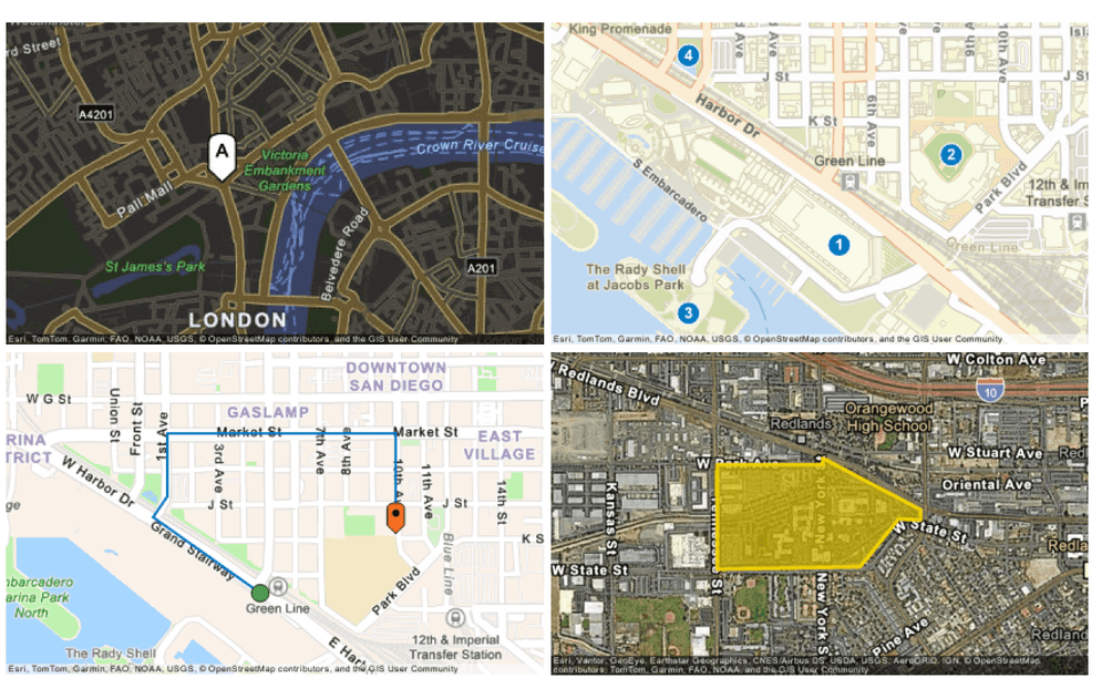
In this tutorial, you use the /with-point, /with-many-points, /with-polyline, and /with-polygon endpoints from the ArcGIS Static Maps service to generate four simple static maps. You also learn how to use default marker symbols and customize the image size and output format.
Prerequisites
You need an ArcGIS Location Platform account to get an access token
Steps
Get an access token
Create a new API key credential
-
If you are familiar with API keys, create an API key credential with the following configurations:
- Type of application: Public application
- Required privileges: Location services > Static maps
If you are new to API keys, go to the Create an API key tutorial for full step-by-step instructions.
-
When prompted, copy and paste the API key to a safe location. It will be used in the next step.
Display a static map with a point
The /with-point endpoint supports GET operations to generate a static map with a point with a default symbol.
-
Define the
/with-pointendpoint and set the basemap style toarcgis/navigation-night. The URL should look like this:Use dark colors for code blocks Copy https://static-maps-api.arcgis.com/arcgis/rest/services/static-maps-service/v1/static-maps/arcgis/navigation-night/with-point -
Send a
GETrequest to generate the static map, including the following query parameters:xto-0.127758.yto51.507351.radiusto1000.symboltoStyle pin.symboltoColor FFFFFF.symboltoScale 2.symboltoLabel A.paddingto[0,20,0,0].widthandheightto600.formattojpeg.tokento your access token.
HTTP HTTP cURL Use dark colors for code blocks Copy GET /arcgis/rest/services/static-maps-service/v1/static-maps/arcgis/navigation-night/with-point?x=-0.127758&y=51.507351&radius=1000&symbolStyle=pin&symbolColor=FFFFFF&symbolScale=2&symbolLabel=A&width=600&height=600&format=jpeg&padding=[0,20,0,0]&token=YOUR_ACCESS_TOKEN HTTP/1.1 Host: static-maps-api.arcgis.com -
You should see a static map centered on Central London, with a white pin symbol labeled
Aand 20 pixels of padding on the right. You can also view the static map in a browser and replaceYOURwith your access token._ACCESS _TOKEN
Display a static map with multiple points
The /with-many-points endpoint supports GET operations to generate a static map with multiple points (up to 10 points) with default symbols.
-
Define the
/with-many-pointsendpoint and set the basemap style toarcgis/streets. The URL should look like this:Use dark colors for code blocks Copy https://static-maps-api.arcgis.com/arcgis/rest/services/static-maps-service/v1/static-maps/arcgis/streets/with-many-points -
Send a
GETrequest to generate the static map, including the following query parameters:pointsto[[-117.1601,32.7055],[-117.1570,32.7076],[-117.1643,32.7039],[-117.1643,32.7099]]symboltoStyle circlelabeltoOption numbersymboltoScale 1symboltoColor 007A C2 widthandheightto400formattopngpaddingto[10]tokento your access token.
HTTP HTTP cURL Use dark colors for code blocks Copy GET /arcgis/rest/services/static-maps-service/v1/static-maps/arcgis/streets/with-many-points?points=[[-117.1601,32.7055],[-117.1570,32.7076],[-117.1643,32.7039],[-117.1643,32.7099]]&symbolStyle=circle&labelOption=number&symbolScale=1&symbolColor=007AC2&width=400&height=400&format=png&padding=[10]&token=YOUR_ACCESS_TOKEN HTTP/1.1 Host: static-maps-api.arcgis.com -
You should see a static map centered on several points in San Diego, California, with numbered circular markers displayed at each location. You can also view the static map in a browser and replace
YOURwith your access token._ACCESS _TOKEN
Display a static map with a polyline
The /with-polyline endpoint supports GET operations to generate a static map with a polyline with up to 10 vertices and default symbols for the start and end points.
-
Define the
/with-polylineendpoint and set the basemap style toarcgis/navigation. The URL should look like this:Use dark colors for code blocks Copy https://static-maps-api.arcgis.com/arcgis/rest/services/static-maps-service/v1/static-maps/arcgis/navigation/with-polyline -
Send a
GETrequest to generate the static map, including the following query parameters:polylineto[[-117.1604,32.7067],[-117.1642,32.7090],[-117.1637,32.7096],[-117.1637,32.7115],[-117.1556,32.7115],[-117.1556,32.7085]]starttoSymbol Style circleendtoSymbol Style pinwidthto400heightto400formattopngpaddingto[25]linetoColor 007A C2 symboltoScale 0.75starttoSymbol Color 35A B46 endtoSymbol Color F36F21 tokento your access token.
HTTP HTTP cURL Use dark colors for code blocks Copy GET /arcgis/rest/services/static-maps-service/v1/static-maps/arcgis/navigation/with-polyline?polyline=[[-117.1604,32.7067],[-117.1642,32.7090],[-117.1637,32.7096],[-117.1637,32.7115],[-117.1556,32.7115],[-117.1556,32.7085]]&startSymbolStyle=circle&endSymbolStyle=pin&width=400&height=400&format=png&padding=[25]&lineColor=007AC2&symbolScale=0.75&startSymbolColor=35AB46&endSymbolColor=F36F21&token=YOUR_ACCESS_TOKEN HTTP/1.1 Host: static-maps-api.arcgis.com -
You should see a static map with a line that represents a route in San Diego, California. The route is drawn as a blue line with a green circle marking the start and an orange pin marking the end. You can also view the static map in a browser and replace
YOURwith your access token._ACCESS _TOKEN
Display a static map with a polygon
The /with-polygon endpoint supports GET operations to generate a static map with a single-part polygon with up to 10 vertices.
-
Define the
/with-polygonendpoint and set the basemap style toarcgis/imagery. The URL should look like this:Use dark colors for code blocks Copy https://static-maps-api.arcgis.com/arcgis/rest/services/static-maps-service/v1/static-maps/arcgis/imagery/with-polygon -
Send a
GETrequest to generate the static map, including the following query parameters:polygonto[[-117.1999995,34.0592131],[-117.1999781,34.0556133],[-117.1940236,34.0556666],[-117.192425,34.0573377],[-117.1915345,34.0572843],[-117.191513,34.0576488],[-117.1956114,34.0593998],[-117.1956222,34.0592131],[-117.1999995,34.0592131]]filltoColor d2b600b8filltoStyle solidoutlinetoColor f0d000fcoutlinetoStyle solidoutlinetoWidth 3widthto400heightto400formattopngzoomto14tokento your access token.
HTTP HTTP cURL Use dark colors for code blocks Copy GET /arcgis/rest/services/static-maps-service/v1/static-maps/arcgis/imagery/with-polygon?fillColor=d2b600b8&fillStyle=solid&format=png&height=400&width=400&outlineColor=f0d000fc&outlineStyle=solid&outlineWidth=3&polygon=[[-117.1999995,34.0592131],[-117.1999781,34.0556133],[-117.1940236,34.0556666],[-117.192425,34.0573377],[-117.1915345,34.0572843],[-117.191513,34.0576488],[-117.1956114,34.0593998],[-117.1956222,34.0592131],[-117.1999995,34.0592131]]&zoom=14&token=YOUR_ACCESS_TOKEN HTTP/1.1 Host: static-maps-api.arcgis.com -
You should see a static map with a polygon in the Esri Headquarters in Redlands, California. The polygon is filled with a semi-transparent color and outlined with a solid border. You can also view the static map in a browser and replace
YOURwith your access token._ACCESS _TOKEN
What's next
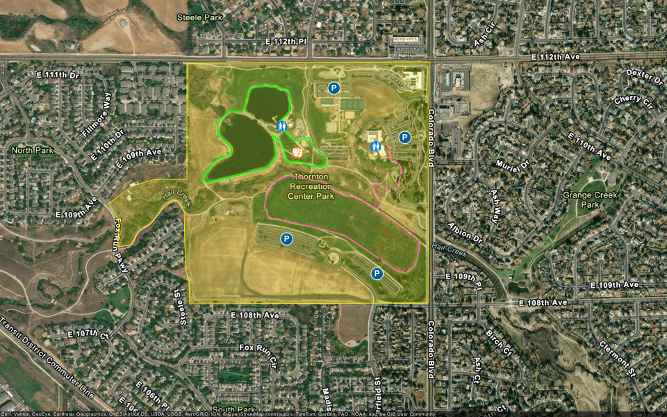
Display a complex static map
Display a static map with multiple geometries and custom marker symbols.