https://static-maps-api.arcgis.com/arcgis/rest/services/static-maps-service/beta-rc/static-maps/arcgis/{arcgis-style}/with-polylineReturns a static map that displays an ArcGIS Basemap style and a polyline as defined by the polyline parameter. The center of the map is specified by centerX and centerY. If the map center is not supplied, it is defined by the extent of the polyline. You can control the geographical extent of the static map with padding values or by defining the zoom or radius parameter.
The start and end of the polyline can be
highlighted using startSymbolStyle and endSymbolStyle parameters,
respectively. The static map image width and height can be defined,
along with the image format, which can be png, jpeg, or webp.
Choose this option if you want to:
- Display a polyline with up to 10 vertices.
- Symbolize the start and end of the line using a simple symbol.
Esri and data attribution must be displayed whenever the static map is visible. Attribution should be placed near the map, or embed within the image or provided through a popup or menu if the map is embedded in an application or website.
The data attribution for an ArcGIS Basemap style can be retrieved from the /static-maps/arcgis/{arcgis-style}/attribution endpoint.
To learn more about attribution requirements for static maps, see Esri and data attribution.
Query parameters
| Name | Type | Required | Default value | Description |
|---|---|---|---|---|
token | string | | An access token with the static maps service privilege. To pass the token as an authorization header, see HTTP authorization headers. | |
polyline | PathGeometryGet | | An array of x,y coordinate pairs defining a polyline in WGS84 spatial reference. Accepts 2 to 10 coordinate pairs. | |
endSymbolLabel | SymbolLabel | | Label displayed on the point symbol at the end of a polyline. Accepts 1–2 alphanumeric characters ( | |
endSymbolColor | string | 007 | Point symbol color at the end of a polyline in hexadecimal format. | |
endSymbolStyle | SymbolStyle | pin | Point symbol style at the end of the polyline. Supported values include | |
lineColor | HexColor | 007 | Line symbol color in hexadecimal format. | |
lineStyle | LineStyle | solid | Line symbol stroke applied to the polyline. Supported values include | |
lineWidth | integer | 4 | Line symbol width in device-independent pixels. Values range from | |
format | ImageFormat | webp | Output image format of the map. Supported formats include | |
height | ImageDimensionHeight | 400 | Height of the map image in pixels. Values must be between | |
width | ImageDimensionWidth | 400 | Width of the map image in pixels. Values must be between | |
padding | ImagePadding | 10 | Padding percentages around the map extent. Accepts an array of 1–4 values; default is | |
startSymbolLabel | SymbolLabel | | Label displayed on the point symbol at the start of a polyline. Accepts 1–2 alphanumeric characters ( | |
startSymbolColor | string | 007 | Point symbol color at the start of a polyline in hexadecimal format. | |
startSymbolStyle | SymbolStyle | pin | Point symbol style at the start of the polyline. Supported values include | |
symbolScale | SymbolScale | 1 | Scale factor applied to the point symbol size. Values range from | |
centerX | number(double) | | X-coordinate of the map center in WGS84 decimal degrees. Values range from | |
centerY | number(double) | | Y-coordinate of the map center in WGS84 decimal degrees. Values range from | |
zoom | ZoomLevel | | A number that defines the level of detail of the map. Values range from | |
radius | RadiusDistance | | A number (in meters) that defines the minimum geographic area around a center point of the map. If no center point is supplied, the radius is applied to the geometry. Values range from | |
attribution | string | auto | Attribution footer style. To learn more about attribution requirements for static maps, see Esri and data attribution. | |
referenceDetails | string | all | A basemap option that controls the visibility of labels and feature symbology. This parameter is currently supported only for the |
token
An access token with the static maps service privilege. To pass the token as an authorization header, see HTTP authorization headers.
The token parameter can be either an API Key or short-lived token.
This parameter is required unless you supply an access token in the request header with one of the following keys using the "Bearer" scheme:
Authorization: Bearer <YOUR_TOKEN>X-Esri-Authorization: Bearer <YOUR_TOKEN>
The provided token must be created from an ArcGIS Location Platform account and have the necessary portal:user:allowBetaAccess privilege to use the static maps service.
polyline
An array of x,y coordinate pairs defining a polyline in WGS84 spatial reference. Accepts 2 to 10 coordinate pairs.
The first coordinate pair in the array represents the start of the polyline, while the last coordinate pair represents the end.
endSymbolLabel
Label displayed on the point symbol at the end of a polyline. Accepts 1–2 alphanumeric characters (A-Z, a-z, 0-9).
- Minimum length
- 1
- Maximum length
- 2
endSymbolColor
Point symbol color at the end of a polyline in hexadecimal format.
It has the format RRGGBB or RRGGBBAA.
RRis the red valueGGis the green valueBBis the blue valueAAis the alpha value.00is fully transparent andFFis a solid fill.
For example, a semi-transparent red color is represented as FF000080.
The default color is a medium-dark shade of blue (007AC2).
- Minimum length
- 6
- Maximum length
- 8
- Default
- 007AC2
endSymbolStyle
Point symbol style at the end of the polyline. Supported values include pin, circle, square, none.
It highlights the end of the polyline or path.
- Default
- pin
Enumerated values
lineColor
Line symbol color in hexadecimal format.
A hexadecimal color code takes the form RRGGBB or RRGGBBAA.
RRis the red valueGGis the green valueBBis the blue valueAAis the alpha value.00is fully transparent andFFis a solid fill.
- Minimum length
- 6
- Maximum length
- 8
- Default
- 007AC2
lineStyle
Line symbol stroke applied to the polyline. Supported values include solid, dash, dot.
The default line style is solid.
- Default
- solid
Enumerated values
lineWidth
Line symbol width in device-independent pixels. Values range from 1 to 16.
- Minimum
- 1
- Maximum
- 16
- Default
- 4
format
Output image format of the map. Supported formats include png, jpeg, and webp.
- Default
- webp
Enumerated values
height
Height of the map image in pixels. Values must be between 128 and 1024.
- Minimum
- 128
- Maximum
- 1024
- Default
- 400
width
Width of the map image in pixels. Values must be between 128 and 1024.
- Minimum
- 128
- Maximum
- 1024
- Default
- 400
padding
Padding percentages around the map extent. Accepts an array of 1–4 values; default is 10 on all sides, maximum is 25.
Padding value is a % of the static map image's width and/or height. It is applied to the static map image, according to the table below:
| Number of values in the array | Description | Example |
|---|---|---|
| One | The same padding % is applied to all four sides. | [10] |
| Two | The first value applies padding to the top and bottom, the second to the left and right sides. | [10, 5 ] |
| Three | The first value applies padding to the top, the second to the left and right sides, and the third to the bottom. | [10, 20, 10] |
| Four | The four values apply padding to the top, right, bottom, and left in a clockwise order. | [10, 5, 5, 20] |
If padding is not specified, a value of 10% is applied to all sides. The maximum allowed padding value is 25%.
- Default
- [10]
startSymbolLabel
Label displayed on the point symbol at the start of a polyline. Accepts 1–2 alphanumeric characters (A-Z, a-z, 0-9).
- Minimum length
- 1
- Maximum length
- 2
startSymbolColor
Point symbol color at the start of a polyline in hexadecimal format.
It has the format RRGGBB or RRGGBBAA.
RRis the red valueGGis the green valueBBis the blue valueAAis the alpha value.00is fully transparent andFFis a solid fill.
For example, a semi-transparent red color is represented as FF000080.
The default color is a medium-dark shade of blue (007AC2).
- Minimum length
- 6
- Maximum length
- 8
- Default
- 007AC2
startSymbolStyle
Point symbol style at the start of the polyline. Supported values include pin, circle, square, and none.
It highlights the beginning of the polyline or path.
- Default
- pin
Enumerated values
symbolScale
Scale factor applied to the point symbol size. Values range from 0.1 to 4.0.
A scale value less than 1.0 indicates that the symbol is scaled down, while a value greater than 1.0 indicates that the symbol is scaled up. For example, a scale of 0.5 will reduce the symbol's dimensions to half its original size. A scale of 2.0 will double the symbol's dimensions.
The minimum scale is 0.1 and the maximum scale is 4.0.
- Minimum
- 0.1
- Maximum
- 4
- Default
- 1
centerX
X-coordinate of the map center in WGS84 decimal degrees. Values range from -179.99 to 179.99.
Setting this value will override the map extent which may result in you graphics not being visible in the map.
- Minimum
- -179.9
- Maximum
- 179.9
centerY
Y-coordinate of the map center in WGS84 decimal degrees. Values range from -85.05 to 85.05.
Setting this value will override the extent of the map, which may result in your graphics not being displayed.
- Minimum
- -85.05
- Maximum
- 85.05
zoom
A number that defines the level of detail of the map. Values range from 0 to 22.
Higher values show more detail over a smaller geographic extent, while lower values show larger areas with less detail.
This parameter is typically used to control map rendering scale, tile selection, and feature visibility.
zoom and radius are mutually exclusive. Use only one or the other.
- Minimum
- 0
- Maximum
- 22
radius
A number (in meters) that defines the minimum geographic area around a center point of the map. If no center point is supplied, the radius is applied to the geometry. Values range from 10 to 20,000,000.
zoom and radius are mutually exclusive. Use only one or the other.
The radius value is used to define the real world radius of the area
displayed in the map image. The area covered by the radius will always
be displayed on the static map image.
If the image width and height are equal, the static map image will be square and the geographic extent displayed by the static map image will match that defined by the radius. However, if the image width is greater than the height, the geographic extent displayed by the static map image will be wider than that defined by the radius.
As a guide, the following radius values can be used for the following types of static maps.
| Radius (meters) | Approximate extent (diameter) | Typical map usage | Zoom |
|---|---|---|---|
| 10 | ~20 m | Building / site | 22–23 |
| 100 | ~200 m | Street / block | 18–19 |
| 1,000 | ~2 km | Neighborhood / district | 15–16 |
| 10,000 | ~20 km | City | 12–13 |
| 100,000 | ~200 km | Metro / region | 9–10 |
| 1,000,000 | ~2,000 km | State / large region | 6–7 |
The radius has a minimum value of 10 meters and a maximum value of
20,000,000 meters.
- Minimum
- 10
- Maximum
- 20000000
attribution
Attribution footer style. To learn more about attribution requirements for static maps, see Esri and data attribution.
auto: Matches the attribution style to the map.light: Light background with dark text.dark: Dark background with light text.none: Displays only “Powered by Esri” without a background.
You must ensure that your map is accompanied by the full attribution statement (see terms of use): if you choose the none option you must include the full attribution string yourself.
- Default
- auto
Enumerated values
referenceDetails
A basemap option that controls the visibility of labels and feature symbology. This parameter is currently supported only for the arcgis/imagery style. Supported values include all and none.
- Default
- all
Enumerated values
Path parameters
| Name | Type | Required | Description |
|---|---|---|---|
arcgis-style | string | The ArcGIS basemap style used to render the map. |
arcgis-style
The ArcGIS basemap style used to render the map.
| Group | Style | Example | Description | Data attribution |
|---|---|---|---|---|
| Streets | navigation | 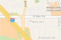 | A custom navigation style designed for use during daylight hours | Esri, TomTom, Garmin, FAO, NOAA, USGS, © OpenStreetMap contributors, and the GIS User Community |
| Streets | navigation-night | 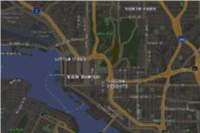 | A custom navigation style designed for use in hours of darkness | Esri, TomTom, Garmin, FAO, NOAA, USGS, © OpenStreetMap contributors, and the GIS User Community |
| Streets | streets | 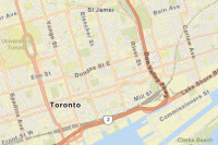 | A classic Esri street map style designed for use during daylight hours | Esri, TomTom, Garmin, FAO, NOAA, USGS, © OpenStreetMap contributors, and the GIS User Community |
| Streets | streets-night | 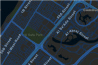 | A classic Esri street map style designed for use in hours of darkness | Esri, TomTom, Garmin, FAO, NOAA, USGS, © OpenStreetMap contributors, and the GIS User Community |
| Satellite | imagery | 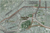 | Low-resolution satellite imagery for the world and high-resolution satellite and aerial imagery, typically within 3-5 years of currency, for most of the world. | Esri, Vantor, GeoEye, Earthstar Geographics, CNES/Airbus DS, USDA, USGS, AeroGRID, IGN, © OpenStreetMap contributors, TomTom, Garmin, FAO, NOAA, and the GIS User Community |
Enumerated values
Response status
| Status | Meaning | Description | Schema |
|---|---|---|---|
| 200 | OK | Static map in a desired image format. | string(binary) |
| 400 | Bad Request | Invalid query parameters / Incorrect portal item type / Data URL parse failure. | Error |
| 401 | Unauthorized | Authentication Error. The API key or token is missing, invalid or expired. | Error |
| 403 | Forbidden | The requested resource cannot be accessed because of incorrect sharing permissions. | Error |
| 404 | Not Found | The requested resource cannot be found - this could be due to missing map data at the requested location and zoom level. | Error |
| 5XX | Server Error | An error occurred on the server. | Error |
Examples
Request
# You can also use wget
curl -X GET 'https://static-maps-api.arcgis.com/arcgis/rest/services/static-maps-service/beta-rc/static-maps/arcgis/streets/with-polyline?polyline=-117.247325%2C34.100934%2C-117.247506%2C34.104433%2C-117.247962%2C34.105095&token=YOUR_TOKEN'