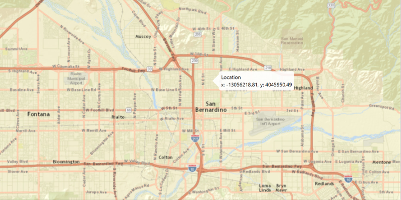
Show a callout with the latitude and longitude of user-clicked points.
Use case
Callouts are used to display temporary detail content on a map. You can display text and arbitrary UI controls in callouts.
How to use the sample
Click anywhere on the map. A callout showing the WGS84 coordinates for the clicked point will appear.
How it works
- Use to create a click event handler.
- Capture the click event and use its x and y coordinates to create a new representing the screen point.
- Get the screen point’s location on the map using .
- Get the ’s callout.
- Set the title and detail of the callout to display the map point’s coordinates.
- Display the callout at the map point .
Relevant API
- Callout
- MapView
- Point
Tags
balloon, bubble, callout, click, flyout, flyover, info window, popup
Sample Code
/* * Copyright 2022 Esri. * * Licensed under the Apache License, Version 2.0 (the "License"); * you may not use this file except in compliance with the License. * You may obtain a copy of the License at * * http://www.apache.org/licenses/LICENSE-2.0 * * Unless required by applicable law or agreed to in writing, software * distributed under the License is distributed on an "AS IS" BASIS, * WITHOUT WARRANTIES OR CONDITIONS OF ANY KIND, either express or implied. * See the License for the specific language governing permissions and * limitations under the License. */
module com.esri.samples.show_callout {  // require ArcGIS Maps SDK for Java module  requires com.esri.arcgisruntime;
  // handle SLF4J http://www.slf4j.org/codes.html#StaticLoggerBinder  requires org.slf4j.nop;
  // require JavaFX modules that the application uses  requires javafx.graphics;
  exports com.esri.samples.show_callout;}
/* * Copyright 2017 Esri. * * Licensed under the Apache License, Version 2.0 (the "License"); you may not * use this file except in compliance with the License. You may obtain a copy of * the License at * * http://www.apache.org/licenses/LICENSE-2.0 * * Unless required by applicable law or agreed to in writing, software * distributed under the License is distributed on an "AS IS" BASIS, WITHOUT * WARRANTIES OR CONDITIONS OF ANY KIND, either express or implied. See the * License for the specific language governing permissions and limitations under * the License. */
package com.esri.samples.show_callout;
import javafx.application.Application;import javafx.geometry.Point2D;import javafx.scene.Scene;import javafx.scene.input.MouseButton;import javafx.scene.layout.StackPane;import javafx.stage.Stage;
import com.esri.arcgisruntime.ArcGISRuntimeEnvironment;import com.esri.arcgisruntime.geometry.GeometryEngine;import com.esri.arcgisruntime.geometry.Point;import com.esri.arcgisruntime.geometry.SpatialReferences;import com.esri.arcgisruntime.mapping.ArcGISMap;import com.esri.arcgisruntime.mapping.BasemapStyle;import com.esri.arcgisruntime.mapping.view.Callout;import com.esri.arcgisruntime.mapping.view.MapView;
public class ShowCalloutSample extends Application {
private MapView mapView;
@Override public void start(Stage stage) {
try { // create stack pane and application scene StackPane stackPane = new StackPane(); Scene scene = new Scene(stackPane);
// set title, size, and add scene to stage stage.setTitle("Show Callout Sample"); stage.setWidth(800); stage.setHeight(700); stage.setScene(scene); stage.show();
// authentication with an API key or named user is required to access basemaps and other location services String yourAPIKey = System.getProperty("apiKey"); ArcGISRuntimeEnvironment.setApiKey(yourAPIKey);
// create a map with the streets relief basemap style ArcGISMap map = new ArcGISMap(BasemapStyle.ARCGIS_STREETS_RELIEF);
// create a map view and set the map to it mapView = new MapView(); mapView.setMap(map);
// get the map view's callout Callout callout = mapView.getCallout();
// click event to display the callout mapView.setOnMouseClicked(e -> {
// check that the primary mouse button was clicked and user is not panning if (e.getButton() == MouseButton.PRIMARY && e.isStillSincePress()) {
// create a point from where the user clicked Point2D point = new Point2D(e.getX(), e.getY());
// create a map point from a point Point mapPoint = mapView.screenToLocation(point);
// project user-tapped map point location Point projectedPoint = (Point)GeometryEngine.project(mapPoint, SpatialReferences.getWgs84());
// set the callout's details callout.setTitle("Location"); callout.setDetail(String.format("Lat: %.3f, Long: %.3f", projectedPoint.getY(), projectedPoint.getX()));
// show the callout where the user clicked callout.showCalloutAt(mapPoint);
// dismiss the callout on secondary click } else if (e.getButton() == MouseButton.SECONDARY && e.isStillSincePress()) { callout.dismiss(); } });
// add map view and control panel to stack pane stackPane.getChildren().addAll(mapView);
} catch (Exception e) { // on any error, print the stack trace e.printStackTrace(); } }
/** * Stops and releases all resources used in application. */ @Override public void stop() {
// release resources when the application closes if (mapView != null) { mapView.dispose(); } }
/** * Opens and runs application. * * @param args arguments passed to this application */ public static void main(String[] args) {
Application.launch(args); }
}