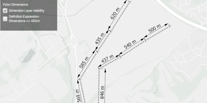
Display dimension features from a mobile map package.
Use case
Dimensions show specific lengths or distances on a map. A dimension may indicate the length of a side of a building or land parcel, or the distance between two features, such as a fire hydrant and the corner of a building.
How to use the sample
When the sample loads, it will automatically display the map containing dimension features from the mobile map package. The name of the dimension layer containing the dimension features is displayed in the controls box. Control the visibility of the dimension layer with the “Dimension Layer visibility” check box, and apply a definition expression to show dimensions of greater than or equal to 450m in length using the “Definition Expression” checkbox.
How it works
- Create a
MobileMapPackagespecifying the path to the .mmpk file. - Load the mobile map package with
mmpk.loadAsync(). - After it successfully loads, get the map from the mmpk and add it to the map view:
mapView.setMap(mmpk.getMaps().get(0)). - Loop through the map’s layers to create a
DimensionLayerand set the name of the layer to the UI withdimensionLayer.getName(). - Control the dimension layer’s visibility with
dimensionLayer.setVisible(boolean)and set a definition expression withdimensionLayer.setDefinitionExpression(String).
Relevant API
- DimensionLayer
- MobileMapPackage
About the data
This sample shows a subset of the Edinburgh, Scotland network of pylons, substations, and powerlines within an Edinburgh Pylon Dimensions mobile map package, digitized from satellite imagery. Note the data is intended as illustrative of the network only.
Additional information
Dimension layers can be taken offline from a feature service hosted on ArcGIS Enterprise 10.9 or later, using the GeodatabaseSyncTask. Dimension layers are also supported in mobile map packages or mobile geodatabases created in ArcGIS Pro 2.9 or later.
Tags
dimension, layer, mmpk, mobile map package, utility
Sample code
/* * Copyright 2021 Esri. * * Licensed under the Apache License, Version 2.0 (the "License"); you may not * use this file except in compliance with the License. You may obtain a copy of * the License at * * http://www.apache.org/licenses/LICENSE-2.0 * * Unless required by applicable law or agreed to in writing, software * distributed under the License is distributed on an "AS IS" BASIS, WITHOUT * WARRANTIES OR CONDITIONS OF ANY KIND, either express or implied. See the * License for the specific language governing permissions and limitations under * the License. */
package com.esri.samples.display_dimensions;
import javafx.application.Application;import javafx.geometry.Insets;import javafx.geometry.Pos;import javafx.scene.Scene;import javafx.scene.control.Alert;import javafx.scene.control.CheckBox;import javafx.scene.control.Label;import javafx.scene.layout.*;import javafx.scene.paint.Paint;import javafx.stage.Stage;
import com.esri.arcgisruntime.layers.DimensionLayer;import com.esri.arcgisruntime.layers.Layer;import com.esri.arcgisruntime.loadable.LoadStatus;import com.esri.arcgisruntime.mapping.MobileMapPackage;import com.esri.arcgisruntime.mapping.view.MapView;
import java.io.File;import java.util.Objects;
public class DisplayDimensionsSample extends Application {
  private DimensionLayer dimensionLayer;  private MapView mapView;  private MobileMapPackage mobileMapPackage; // keep loadable in scope to avoid garbage collection
  @Override  public void start(Stage stage) {    try {      // create stack pane and application scene      StackPane stackPane = new StackPane();      Scene scene = new Scene(stackPane);      scene.getStylesheets().add(Objects.requireNonNull(getClass().getResource("/display_dimensions/style.css")).toExternalForm());
      // set title, size, and add scene to stage      stage.setTitle("Display Dimensions Sample");      stage.setWidth(800);      stage.setHeight(700);      stage.setScene(scene);      stage.show();
      // set up display label for dimension layer name, and check boxes for controlling visibility and definition expression      Label dimensionLayerName = new Label();      CheckBox visibilityCheckBox = new CheckBox("Dimension Layer visibility");      visibilityCheckBox.setSelected(true);      CheckBox defExpressionCheckBox = new CheckBox("Definition Expression:" + "\n" + "Dimensions >= 450m");      defExpressionCheckBox.setWrapText(true);
      // add the label and checkboxes to a JavaFX VBox      VBox controlsVBox = new VBox(6);      controlsVBox.setBackground(new Background(new BackgroundFill(Paint.valueOf("rgba(0,0,0,0.5)"), CornerRadii.EMPTY,        Insets.EMPTY)));      controlsVBox.setPadding(new Insets(10.0));      controlsVBox.setMaxSize(220, 120);      controlsVBox.getStyleClass().add("panel-region");      controlsVBox.getChildren().addAll(dimensionLayerName, visibilityCheckBox, defExpressionCheckBox);      controlsVBox.setDisable(true);
      // create a map view      mapView = new MapView();
      // create and load a mobile map package      final String mmpkPath = new File(System.getProperty("data.dir"), "./samples-data/mmpk/EdinburghPylonsDimensions.mmpk").getAbsolutePath();      mobileMapPackage = new MobileMapPackage(mmpkPath);
      mobileMapPackage.addDoneLoadingListener(() -> {        // check the mmpk has loaded successfully and that it contains a map        if (mobileMapPackage.getLoadStatus() == LoadStatus.LOADED && !mobileMapPackage.getMaps().isEmpty()) {          // add the map from the mobile map package to the map view, and set a min scale to maintain dimension readability          mapView.setMap(mobileMapPackage.getMaps().get(0));          mapView.getMap().setMinScale(35000);
          // find the dimension layer within the map          for (Layer layer : mapView.getMap().getOperationalLayers()) {            if (layer instanceof DimensionLayer) {              dimensionLayer = (DimensionLayer) layer;              // set the label to the name of the dimension layer              dimensionLayerName.setText(dimensionLayer.getName());              // enable the vbox for dimension layer controls              controlsVBox.setDisable(false);              visibilityCheckBox.setSelected(dimensionLayer.isVisible());            }          }        } else {          new Alert(Alert.AlertType.ERROR, "Failed to load the mobile map package").show();        }      });      mobileMapPackage.loadAsync();
      // set a definition expression to show dimension lengths of greater than or equal to 450m when the checkbox is selected,      // or to reset the definition expression to show all dimension lengths when unselected      defExpressionCheckBox.setOnAction(e -> {        String defExpression = defExpressionCheckBox.isSelected() ? "DIMLENGTH >= 450" : "";        dimensionLayer.setDefinitionExpression(defExpression);      });
      // set the visibility of the dimension layer      visibilityCheckBox.setOnAction(e -> dimensionLayer.setVisible(visibilityCheckBox.isSelected()));
      // add the map view to stack pane      stackPane.getChildren().addAll(mapView, controlsVBox);      StackPane.setAlignment(controlsVBox, Pos.TOP_LEFT);      StackPane.setMargin(controlsVBox, new Insets(10, 0, 0, 10));    } catch(Exception e){      // on any error, display the stack trace.      e.printStackTrace();    }  }
  /**   * Stops and releases all resources used in application.   */  @Override  public void stop() {
    if (mapView != null) {      mapView.dispose();    }  }
  /**   * Opens and runs application.   *   * @param args arguments passed to this application   */  public static void main(String[] args) {
    Application.launch(args);  }}