Display nautical charts per the ENC specification.
Use case
The ENC specification describes how hydrographic data should be displayed digitally.
An ENC exchange set is a catalog of data files which can be loaded as cells. The cells contain information on how symbols should be displayed in relation to one another, so as to represent information such as depth and obstacles accurately.
How to use the sample
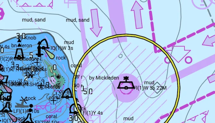
Run the sample and view the ENC data. Pan and zoom around the map. Take note of the high level of detail in the data and the smooth rendering of the layer.
How it works
- Specify the path to a local CATALOG.031 file to create an
EncExchangeSet. - After loading the exchange set, get the
EncDatasetobjects in the exchange set withEncExchangeSet.datasets. - Create an
EncCellfor each dataset. Then create anEncLayerfor each cell. - Add the ENC layer to a map’s operational layers collection to display it.
Relevant API
- EncCell
- EncDataset
- EncExchangeSet
- EncLayer
Offline data
This sample downloads the ENC Exchange Set without updates and Hydrography dataset resources from ArcGIS Online.
Additional information
This sample uses the GeoView-Compose Toolkit module to be able to implement a composable SceneView.
Tags
data, ENC, geoview-compose, hydrographic, layers, maritime, nautical chart
Sample code
/* Copyright 2024 Esri * * Licensed under the Apache License, Version 2.0 (the "License"); * you may not use this file except in compliance with the License. * You may obtain a copy of the License at * *    http://www.apache.org/licenses/LICENSE-2.0 * * Unless required by applicable law or agreed to in writing, software * distributed under the License is distributed on an "AS IS" BASIS, * WITHOUT WARRANTIES OR CONDITIONS OF ANY KIND, either express or implied. * See the License for the specific language governing permissions and * limitations under the License. * */
package com.esri.arcgismaps.sample.addencexchangeset.components
import android.app.Applicationimport androidx.compose.runtime.getValueimport androidx.compose.runtime.mutableStateOfimport androidx.compose.runtime.setValueimport androidx.lifecycle.AndroidViewModelimport androidx.lifecycle.viewModelScopeimport com.arcgismaps.geometry.Envelopeimport com.arcgismaps.geometry.GeometryEngineimport com.arcgismaps.hydrography.EncCellimport com.arcgismaps.hydrography.EncEnvironmentSettingsimport com.arcgismaps.hydrography.EncExchangeSetimport com.arcgismaps.mapping.ArcGISMapimport com.arcgismaps.mapping.BasemapStyleimport com.arcgismaps.mapping.Viewpointimport com.arcgismaps.mapping.layers.EncLayerimport com.esri.arcgismaps.sample.addencexchangeset.Rimport com.esri.arcgismaps.sample.sampleslib.components.MessageDialogViewModelimport kotlinx.coroutines.launchimport java.io.File
class MapViewModel(application: Application) : AndroidViewModel(application) {    private val provisionPath: String by lazy {        application.getExternalFilesDir(null)?.path.toString() +                File.separator +                application.getString(R.string.add_enc_exchange_set_app_name)    }
    // Paths to ENC data and hydrology resources    private val encResourcesPath = provisionPath + application.getString(R.string.enc_res_dir)    private val encDataPath = provisionPath + application.getString(R.string.enc_data_dir)
    // Create an ENC exchange set from the local ENC data    private val encExchangeSet = EncExchangeSet(listOf(encDataPath))    private val encEnvironmentSettings: EncEnvironmentSettings = EncEnvironmentSettings
    // Create an empty map, to be updated once ENC data is loaded    var arcGISMap by mutableStateOf(ArcGISMap())
    // Create a message dialog view model for handling error messages    val messageDialogVM = MessageDialogViewModel()
    init {        // Provide ENC environment with location of ENC resources and configure SENC caching location        encEnvironmentSettings.resourcePath = encResourcesPath        encEnvironmentSettings.sencDataPath = application.externalCacheDir?.path
        viewModelScope.launch {            encExchangeSet.load().onSuccess {
                // Calculate the combined extent of all datasets in the exchange set                val exchangeSetExtent: Envelope? = encExchangeSet.extentOrNull()
                // Set the map to the oceans basemap style, and viewpoint to the exchange set extent                arcGISMap = ArcGISMap(BasemapStyle.ArcGISOceans).apply {                    exchangeSetExtent?.let {                        initialViewpoint = Viewpoint(exchangeSetExtent)                    }                }
                encExchangeSet.datasets.forEach { encDataset ->                    // Create a layer for each ENC dataset and add it to the map                    val encCell = EncCell(encDataset)                    val encLayer = EncLayer(encCell)                    arcGISMap.operationalLayers.add(encLayer)
                    encLayer.load().onFailure { err ->                        messageDialogVM.showMessageDialog(                            "Error loading ENC layer",                            err.message.toString()                        )                    }                }            }.onFailure { err ->                messageDialogVM.showMessageDialog(                    "Error loading ENC exchange set",                    err.message.toString()                )            }        }    }}
/** * Get the combined extent of every dataset in the exchange set. */private fun EncExchangeSet.extentOrNull(): Envelope? {    var extent: Envelope? = null
    datasets.forEach { dataset ->        if (extent == null) {            extent = dataset.extent        }
        if (extent != null && dataset.extent != null) {            // Update the combined extent of the exchange set if geometry engine returns non-null            extent = GeometryEngine.combineExtentsOrNull(extent, dataset.extent!!) ?: extent        }    }    return extent}
/* Copyright 2024 Esri * * Licensed under the Apache License, Version 2.0 (the "License"); * you may not use this file except in compliance with the License. * You may obtain a copy of the License at * * http://www.apache.org/licenses/LICENSE-2.0 * * Unless required by applicable law or agreed to in writing, software * distributed under the License is distributed on an "AS IS" BASIS, * WITHOUT WARRANTIES OR CONDITIONS OF ANY KIND, either express or implied. * See the License for the specific language governing permissions and * limitations under the License. * */
package com.esri.arcgismaps.sample.addencexchangeset
import android.content.Intentimport android.os.Bundleimport com.esri.arcgismaps.sample.sampleslib.DownloaderActivity
class DownloadActivity : DownloaderActivity() { override fun onCreate(savedInstanceState: Bundle?) { super.onCreate(savedInstanceState) downloadAndStartSample( Intent(this, MainActivity::class.java), // get the app name of the sample getString(R.string.add_enc_exchange_set_app_name), listOf( // ArcGIS Portal item containing ENC hydrography resources "https://www.arcgis.com/home/item.html?id=5028bf3513ff4c38b28822d010a4937c", // ArcGIS Portal item containing the ENC dataset "https://www.arcgis.com/home/item.html?id=9d2987a825c646468b3ce7512fb76e2d" ) ) }}/* Copyright 2024 Esri * * Licensed under the Apache License, Version 2.0 (the "License"); * you may not use this file except in compliance with the License. * You may obtain a copy of the License at * * http://www.apache.org/licenses/LICENSE-2.0 * * Unless required by applicable law or agreed to in writing, software * distributed under the License is distributed on an "AS IS" BASIS, * WITHOUT WARRANTIES OR CONDITIONS OF ANY KIND, either express or implied. * See the License for the specific language governing permissions and * limitations under the License. * */
package com.esri.arcgismaps.sample.addencexchangeset
import android.os.Bundleimport androidx.activity.ComponentActivityimport androidx.activity.compose.setContentimport androidx.activity.enableEdgeToEdgeimport androidx.compose.material3.MaterialThemeimport androidx.compose.material3.Surfaceimport androidx.compose.runtime.Composableimport com.arcgismaps.ApiKeyimport com.arcgismaps.ArcGISEnvironmentimport com.esri.arcgismaps.sample.sampleslib.theme.SampleAppThemeimport com.esri.arcgismaps.sample.addencexchangeset.screens.MainScreen
class MainActivity : ComponentActivity() {
override fun onCreate(savedInstanceState: Bundle?) { super.onCreate(savedInstanceState) // authentication with an API key or named user is // required to access basemaps and other location services ArcGISEnvironment.apiKey = ApiKey.create(BuildConfig.ACCESS_TOKEN)
enableEdgeToEdge() setContent { SampleAppTheme { SampleApp() } } }
@Composable private fun SampleApp() { Surface( color = MaterialTheme.colorScheme.background ) { MainScreen( sampleName = getString(R.string.add_enc_exchange_set_app_name) ) } }}/* Copyright 2024 Esri * * Licensed under the Apache License, Version 2.0 (the "License"); * you may not use this file except in compliance with the License. * You may obtain a copy of the License at * * http://www.apache.org/licenses/LICENSE-2.0 * * Unless required by applicable law or agreed to in writing, software * distributed under the License is distributed on an "AS IS" BASIS, * WITHOUT WARRANTIES OR CONDITIONS OF ANY KIND, either express or implied. * See the License for the specific language governing permissions and * limitations under the License. * */
package com.esri.arcgismaps.sample.addencexchangeset.screens
import androidx.compose.foundation.layout.fillMaxSizeimport androidx.compose.foundation.layout.paddingimport androidx.compose.material3.Scaffoldimport androidx.compose.runtime.Composableimport androidx.compose.ui.Modifierimport androidx.lifecycle.viewmodel.compose.viewModelimport com.arcgismaps.toolkit.geoviewcompose.MapViewimport com.esri.arcgismaps.sample.addencexchangeset.components.MapViewModelimport com.esri.arcgismaps.sample.sampleslib.components.MessageDialogimport com.esri.arcgismaps.sample.sampleslib.components.SampleTopAppBar
/** * Main screen layout for the sample app */@Composablefun MainScreen(sampleName: String) { // create a ViewModel to handle MapView interactions val mapViewModel: MapViewModel = viewModel()
Scaffold( topBar = { SampleTopAppBar(title = sampleName) }, content = { MapView( modifier = Modifier .fillMaxSize() .padding(it), arcGISMap = mapViewModel.arcGISMap, ) mapViewModel.messageDialogVM.apply { if (dialogStatus) { MessageDialog( title = messageTitle, description = messageDescription, onDismissRequest = ::dismissDialog ) } } } )}