Display dimension features from a mobile map package.
Use case
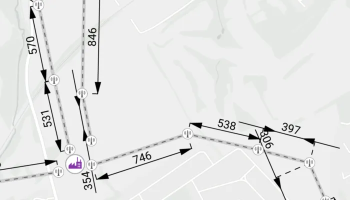
Dimensions show specific lengths or distances on a map. A dimension may indicate the length of a side of a building or land parcel, or the distance between two features, such as a fire hydrant and the corner of a building.
How to use the sample
When the sample loads, it will automatically display the map containing dimension features from the mobile map package. The name of the dimension layer containing the dimension features is displayed in the controls box. Control the visibility of the dimension layer with the “Dimension Settings” button, and apply a definition expression to show dimensions of greater than or equal to 450m in length using the “Definition Expression” switch.
How it works
- Create a
MobileMapPackagespecifying the path to the .mmpk file. - Load the mobile map package with
mobileMapPackage.load(). - After it successfully loads, get the first map from the mmpk and set it to the map view:
mapView.map = mobileMapPackage.maps[0]. - Loop through the map’s layers to create a
DimensionLayer. - Control the dimension layer’s visibility with
dimensionLayer.isVisibleand set a definition expression withdimensionLayer.definitionExpression.
Relevant API
- DimensionLayer
- MobileMapPackage
About the data
This sample shows a subset of the Edinburgh, Scotland network of pylons, substations, and powerlines within an Edinburgh Pylon Dimensions mobile map package, digitized from satellite imagery. Note the data is intended as illustrative of the network only.
Additional information
Dimension layers can be taken offline from a feature service hosted on ArcGIS Enterprise 10.9 or later, using the GeodatabaseSyncTask. Dimension layers are also supported in mobile map packages or mobile geodatabases created in ArcGIS Pro 2.9 or later.
Tags
dimension, layer, mmpk, mobile map package, utility
Sample code
/* Copyright 2023 Esri * * Licensed under the Apache License, Version 2.0 (the "License"); * you may not use this file except in compliance with the License. * You may obtain a copy of the License at * *    http://www.apache.org/licenses/LICENSE-2.0 * * Unless required by applicable law or agreed to in writing, software * distributed under the License is distributed on an "AS IS" BASIS, * WITHOUT WARRANTIES OR CONDITIONS OF ANY KIND, either express or implied. * See the License for the specific language governing permissions and * limitations under the License. * */
package com.esri.arcgismaps.sample.displaydimensions
import android.os.Bundleimport android.util.Logimport com.esri.arcgismaps.sample.sampleslib.EdgeToEdgeCompatActivityimport androidx.databinding.DataBindingUtilimport androidx.lifecycle.lifecycleScopeimport com.arcgismaps.ApiKeyimport com.arcgismaps.ArcGISEnvironmentimport com.arcgismaps.mapping.MobileMapPackageimport com.arcgismaps.mapping.layers.DimensionLayerimport com.esri.arcgismaps.sample.displaydimensions.databinding.DimensionsDialogLayoutBindingimport com.esri.arcgismaps.sample.displaydimensions.databinding.DisplayDimensionsActivityMainBindingimport com.google.android.material.dialog.MaterialAlertDialogBuilderimport com.google.android.material.snackbar.Snackbarimport kotlinx.coroutines.launchimport java.io.File
class MainActivity : EdgeToEdgeCompatActivity() {
    private val provisionPath: String by lazy {        getExternalFilesDir(null)?.path.toString() + File.separator + getString(R.string.display_dimensions_app_name)    }
    private val activityMainBinding: DisplayDimensionsActivityMainBinding by lazy {        DataBindingUtil.setContentView(this, R.layout.display_dimensions_activity_main)    }
    private val mapView by lazy {        activityMainBinding.mapView    }
    private val optionsButton by lazy {        activityMainBinding.optionsButton    }
    // keep an instance of the MapView's dimension layer    private var dimensionLayer: DimensionLayer? = null
    // track if the layer is enabled    private var isDimensionLayerEnabled: Boolean = true
    // track if the custom definition is enabled    private var isDefinitionEnabled: Boolean = false
    override fun onCreate(savedInstanceState: Bundle?) {        super.onCreate(savedInstanceState)
        // authentication with an API key or named user is        // required to access basemaps and other location services        ArcGISEnvironment.apiKey = ApiKey.create(BuildConfig.ACCESS_TOKEN)        lifecycle.addObserver(mapView)
        // check if the .mmpk file exits        val mmpkFile = File(provisionPath, getString(R.string.file_name))        if (!mmpkFile.exists()) return showError("Mobile map package file does not exist.")
        // create and load a mobile map package        val mobileMapPackage = MobileMapPackage(mmpkFile.path)
        lifecycleScope.launch {            // load the mobile map package            mobileMapPackage.load().getOrElse {                return@launch showError("Failed to load the mobile map package: ${it.message}")            }            // if the loaded mobile map package does not contain a map            if (mobileMapPackage.maps.isEmpty()) {                return@launch showError("Mobile map package does not contain a map")            }
            // add the map from the mobile map package to the map view,            // and set a min scale to maintain dimension readability            mapView.map = mobileMapPackage.maps[0]            mapView.map?.minScale = 35000.0
            // set the dimension layer within the map            dimensionLayer = mapView.map?.operationalLayers?.firstOrNull { layer ->                layer is DimensionLayer            } as DimensionLayer
        }
        optionsButton.setOnClickListener {            // inflate the dialog layout and get references to each of its components            val dialogBinding = DimensionsDialogLayoutBinding.inflate(layoutInflater)            dialogBinding.dimensionLayerSwitch.apply {                isChecked = isDimensionLayerEnabled                setOnCheckedChangeListener { _, isEnabled ->                    // set the visibility of the dimension layer                    dimensionLayer?.isVisible = isEnabled                    isDimensionLayerEnabled = isEnabled                }            }            dialogBinding.definitionSwitch.apply {                isChecked = isDefinitionEnabled                setOnCheckedChangeListener { _, isEnabled ->                    // set a definition expression to show dimension lengths of                    // greater than or equal to 450m when the checkbox is selected,                    // or to reset the definition expression to show all                    // dimension lengths when unselected                    val defExpression = if (isEnabled) "DIMLENGTH >= 450" else ""                    dimensionLayer?.definitionExpression = defExpression                    isDefinitionEnabled = isEnabled                }            }
            // set up the dialog            MaterialAlertDialogBuilder(this).apply {                setView(dialogBinding.root)                setTitle("${getString(R.string.settings)}: ${dimensionLayer?.name}")            }.show()        }    }
    private fun showError(message: String) {        Log.e(localClassName, message)        Snackbar.make(mapView, message, Snackbar.LENGTH_SHORT).show()    }}
/* Copyright 2023 Esri * * Licensed under the Apache License, Version 2.0 (the "License"); * you may not use this file except in compliance with the License. * You may obtain a copy of the License at * * http://www.apache.org/licenses/LICENSE-2.0 * * Unless required by applicable law or agreed to in writing, software * distributed under the License is distributed on an "AS IS" BASIS, * WITHOUT WARRANTIES OR CONDITIONS OF ANY KIND, either express or implied. * See the License for the specific language governing permissions and * limitations under the License. * */
package com.esri.arcgismaps.sample.displaydimensions
import android.content.Intentimport android.os.Bundleimport com.esri.arcgismaps.sample.sampleslib.DownloaderActivity
class DownloadActivity : DownloaderActivity() { override fun onCreate(savedInstanceState: Bundle?) { super.onCreate(savedInstanceState) downloadAndStartSample( Intent(this, MainActivity::class.java), // get the app name of the sample getString(R.string.display_dimensions_app_name), listOf( // ArcGIS Portal item containing the mmpk file which is a section of the // high-voltage electricity transmission network around Edinburgh, Scotland. "https://www.arcgis.com/home/item.html?id=f5ff6f5556a945bca87ca513b8729a1e" ) ) }}