Display coordinate system grids including Latitude/Longitude, MGRS, UTM and USNG on a map view. Also, toggle label visibility and change the color of grid lines and grid labels.
Use case
Grids are often used on printed maps, but can also be helpful on digital maps, to identify locations on a map.
How to use the sample
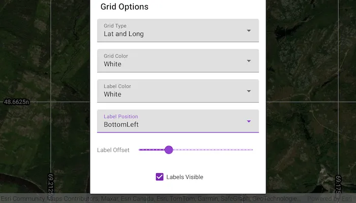
Tap on the Change Grid button in the toolbar to open a settings view. You can change the view from 2D or 3D, select the type of grid from Grid Type (LatLong, MGRS, UTM, and USNG) and modify its properties like label visibility, grid line color, grid label color, label formatting, and label offset.
How it works
- Create an instance of one of the
Gridtypes. - Grid lines and labels can be styled per grid level with
setLineSymbol(gridLevel, lineSymbol)andsetTextSymbol(gridLevel, textSymbol)methods on the grid. - The label position can be set with
grid.labelPositionmethod on the grid. - For the
LatitudeLongitudeGridtype, you can specify a label format ofDecimalDegreesorDegreesMinutesSeconds. - For all screen-aligned label placement strategies, you can set the labels’ offset in device-independent pixels (DIPs) from the screen edge with
grid.labelOffset(offset). - To set the grid, use the
mapView.grid(grid)method on the map view or scene view.
Relevant API
- Grid
- LatitudeLongitudeGrid
- MapView
- MgrsGrid
- SimpleLineSymbol
- TextSymbol
- UsngGrid
- UtmGrid
Tags
coordinates, degrees, graticule, grid, latitude, longitude, mgrs, minutes, seconds, usng, utm
Sample code
MainActivity.kt
/* Copyright 2023 Esri * * Licensed under the Apache License, Version 2.0 (the "License"); * you may not use this file except in compliance with the License. * You may obtain a copy of the License at * *    http://www.apache.org/licenses/LICENSE-2.0 * * Unless required by applicable law or agreed to in writing, software * distributed under the License is distributed on an "AS IS" BASIS, * WITHOUT WARRANTIES OR CONDITIONS OF ANY KIND, either express or implied. * See the License for the specific language governing permissions and * limitations under the License. * */
package com.esri.arcgismaps.sample.showgrid
import android.os.Bundleimport android.util.Logimport android.widget.AdapterViewimport android.widget.ArrayAdapterimport com.esri.arcgismaps.sample.sampleslib.EdgeToEdgeCompatActivityimport androidx.databinding.DataBindingUtilimport com.arcgismaps.ApiKeyimport com.arcgismaps.ArcGISEnvironmentimport com.arcgismaps.Colorimport com.arcgismaps.geometry.Pointimport com.arcgismaps.geometry.SpatialReferenceimport com.arcgismaps.mapping.ArcGISMapimport com.arcgismaps.mapping.BasemapStyleimport com.arcgismaps.mapping.Viewpointimport com.arcgismaps.mapping.symbology.HorizontalAlignmentimport com.arcgismaps.mapping.symbology.LineSymbolimport com.arcgismaps.mapping.symbology.SimpleLineSymbolimport com.arcgismaps.mapping.symbology.SimpleLineSymbolStyleimport com.arcgismaps.mapping.symbology.TextSymbolimport com.arcgismaps.mapping.symbology.VerticalAlignmentimport com.arcgismaps.mapping.view.GridLabelPositionimport com.arcgismaps.mapping.view.LatitudeLongitudeGridimport com.arcgismaps.mapping.view.LatitudeLongitudeGridLabelFormatimport com.arcgismaps.mapping.view.MgrsGridimport com.arcgismaps.mapping.view.UsngGridimport com.arcgismaps.mapping.view.UtmGridimport com.esri.arcgismaps.sample.showgrid.databinding.PopupDialogBindingimport com.esri.arcgismaps.sample.showgrid.databinding.ShowGridActivityMainBindingimport com.google.android.material.button.MaterialButtonimport com.google.android.material.dialog.MaterialAlertDialogBuilderimport com.google.android.material.snackbar.Snackbar
class MainActivity : EdgeToEdgeCompatActivity() {
    // set up data binding for the activity    private val activityMainBinding: ShowGridActivityMainBinding by lazy {        DataBindingUtil.setContentView(this, R.layout.show_grid_activity_main)    }
    private val mapView by lazy {        activityMainBinding.mapView    }
    private val menuButton: MaterialButton by lazy {        activityMainBinding.menuButton    }
    // create a point to focus the map on in Quebec province    private val center: Point = Point(        -7702852.905619, 6217972.345771, SpatialReference(3857)    )
    // the selected line color of the grid    private var lineColor: Color = Color.white
    // the selected label color of the grid    private var labelColor: Color = Color.white
    // the selected label position of the grid    private var labelPosition: GridLabelPosition = GridLabelPosition.AllSides
    // boolean set if the layer is visible    private var isLabelVisible = true
    // create a popup dialog to manage grid settings    private val popUpDialogBinding by lazy {        PopupDialogBinding.inflate(layoutInflater)    }

    override fun onCreate(savedInstanceState: Bundle?) {        super.onCreate(savedInstanceState)
        // authentication with an API key or named user is        // required to access basemaps and other location services        ArcGISEnvironment.apiKey = ApiKey.create(BuildConfig.ACCESS_TOKEN)        lifecycle.addObserver(mapView)
        mapView.apply {            // create a map with imagery basemap            map = ArcGISMap(BasemapStyle.ArcGISImagery)            // set the initial viewpoint of the map            setViewpoint(Viewpoint(center, 23227.0))            // set defaults on grid            grid = LatitudeLongitudeGrid()        }
        val dialog = MaterialAlertDialogBuilder(this@MainActivity).apply {            setView(popUpDialogBinding.root)            setTitle(getString(R.string.change_grid_button))        }.create()
        // set up options in popup menu        // create drop-down list of different layer types        setupLayerDropdown(popUpDialogBinding)
        // create drop-down list of different line colors        setupLineColorDropdown(popUpDialogBinding)
        // create drop-down list of different label colors        setupLabelColorDropdown(popUpDialogBinding)
        // create drop-down list of different label positions        setupLabelPositionDropdown(popUpDialogBinding)
        // create slider to offset label positions        setupLabelOffset(popUpDialogBinding)
        // setup the checkbox to change the visibility of the labels        setupLabelsCheckbox(popUpDialogBinding)
        // display pop-up box when button is clicked        menuButton.setOnClickListener {            dialog.show()        }    }
    /**     * Sets up the [popupDialogBinding] for selecting a grid type     * and handles behavior for when a new grid type is selected.     */    private fun setupLayerDropdown(popupDialogBinding: PopupDialogBinding) {        popupDialogBinding.gridTypeDropdown.apply {            // set the grid type adapter            setAdapter(ArrayAdapter(                applicationContext,                com.esri.arcgismaps.sample.sampleslib.R.layout.custom_dropdown_item,                resources.getStringArray(R.array.layers_array))            )
            // set the grid type click listener            onItemClickListener = AdapterView.OnItemClickListener { _, _, position, _ ->                when (position) {                    0 -> {                        // LatitudeLongitudeGrid can have a label format of DecimalDegrees or DegreesMinutesSeconds                        mapView.grid = LatitudeLongitudeGrid().apply {                            labelFormat = LatitudeLongitudeGridLabelFormat.DecimalDegrees                        }                        mapView.setViewpoint(Viewpoint(center, 23227.0))                    }                    1 -> {                        mapView.grid = MgrsGrid()                        mapView.setViewpoint(Viewpoint(center, 23227.0))                    }                    2 -> {                        mapView.grid = UtmGrid()                        mapView.setViewpoint(Viewpoint(center, 10000000.0))                    }                    3 -> {                        mapView.grid = UsngGrid()                        mapView.setViewpoint(Viewpoint(center, 23227.0))                    }                    else -> return@OnItemClickListener showError("Unsupported option")                }
                // make sure settings persist on grid type change                setLabelVisibility(isLabelVisible)                changeGridColor(lineColor)                changeLabelColor(labelColor)            }        }    }
    /**     * Sets up the [popupDialogBinding] for selecting a grid color and     * handles behavior for when a new line color is selected.     */    private fun setupLineColorDropdown(popupDialogBinding: PopupDialogBinding) {        popupDialogBinding.gridColorDropdown.apply {            // set the grid color adapter            setAdapter(ArrayAdapter(                applicationContext,                com.esri.arcgismaps.sample.sampleslib.R.layout.custom_dropdown_item,                resources.getStringArray(R.array.colors_array))            )
            // set the grid color click listener            onItemClickListener = AdapterView.OnItemClickListener { _, _, position, _ ->                lineColor = when (position) {                    0 -> Color.red                    1 -> Color.white                    2 -> Color.blue                    else -> return@OnItemClickListener showError("Unsupported option")                }                changeGridColor(lineColor)            }        }    }
    /**     * Sets up the [popupDialogBinding] for selecting a label color     * and handles behavior for when a new label color is selected.     */    private fun setupLabelColorDropdown(popupDialogBinding: PopupDialogBinding) {        popupDialogBinding.labelColorDropdown.apply {            setAdapter(ArrayAdapter(                applicationContext,                com.esri.arcgismaps.sample.sampleslib.R.layout.custom_dropdown_item,                resources.getStringArray(R.array.colors_array))            )            onItemClickListener = AdapterView.OnItemClickListener { _, _, position, _ ->                // change grid labels color                labelColor = when (position) {                    0 -> Color.red                    1 -> Color.white                    2 -> Color.blue                    else -> return@OnItemClickListener showError("Unsupported option")                }                changeLabelColor(labelColor)            }        }    }
    /**     * Sets up the [popupDialogBinding] for selecting a label position relative to the grid     * and handles behavior for when a label position is selected.     */    private fun setupLabelPositionDropdown(popupDialogBinding: PopupDialogBinding) {        popupDialogBinding.labelPositionDropdown.apply {            setAdapter(ArrayAdapter(                applicationContext,                com.esri.arcgismaps.sample.sampleslib.R.layout.custom_dropdown_item,                resources.getStringArray(R.array.positions_array))            )
            onItemClickListener = AdapterView.OnItemClickListener { _, _, position, _ ->                // set the label position                labelPosition = when (position) {                    0 -> GridLabelPosition.AllSides                    1 -> GridLabelPosition.BottomLeft                    2 -> GridLabelPosition.BottomRight                    3 -> GridLabelPosition.Center                    4 -> GridLabelPosition.Geographic                    5 -> GridLabelPosition.TopLeft                    6 -> GridLabelPosition.TopRight                    else -> return@OnItemClickListener showError("Unsupported option")                }                // only enable label offset slider if the label position is not Center or Geographic                popUpDialogBinding.labelOffsetSlider.isEnabled =                    !(labelPosition == GridLabelPosition.Center || labelPosition == GridLabelPosition.Geographic)
                changeLabelPosition(labelPosition)            }        }    }
    /**     * Sets up the [popupDialogBinding] for the label offset slider     * and handles behavior for when the slider value changes.     */    private fun setupLabelOffset(popupDialogBinding: PopupDialogBinding) {        popupDialogBinding.labelOffsetSlider.apply {            // set the label offset slider listener            addOnChangeListener { _, value, _ ->                val grid = mapView.grid ?: return@addOnChangeListener                // set the label offset based on the slider value                grid.labelOffset = value.toDouble()            }        }    }
    /**     * Sets up the [popupDialogBinding] for the checkbox making labels visible or invisible.     */    private fun setupLabelsCheckbox(popupDialogBinding: PopupDialogBinding) {        popupDialogBinding.labelsCheckBox.apply {            isChecked = true            // hide and show label visibility when the checkbox is clicked            setOnClickListener {                isLabelVisible = isChecked                setLabelVisibility(isLabelVisible)            }        }    }
    /**     * Sets the labels visibility based on [isVisible].     */    private fun setLabelVisibility(isVisible: Boolean) {        val grid = mapView.grid ?: return        grid.labelVisibility = isVisible    }
    /**     * Sets the [color] of the grid lines.     */    private fun changeGridColor(color: Color) {        val grid = mapView.grid ?: return        val gridLevels = grid.levelCount        for (gridLevel in 0 until gridLevels) {            val lineSymbol: LineSymbol =                SimpleLineSymbol(SimpleLineSymbolStyle.Solid, color, (gridLevel + 1).toFloat())            grid.setLineSymbol(gridLevel, lineSymbol)        }    }
    /**     * Sets the [labelColor] of the labels on the grid.     */    private fun changeLabelColor(labelColor: Color) {        val grid = mapView.grid ?: return        val gridLevels = grid.levelCount        for (gridLevel in 0 until gridLevels) {            val textSymbol = TextSymbol().apply {                color = labelColor                size = 14f                horizontalAlignment = HorizontalAlignment.Left                verticalAlignment = VerticalAlignment.Bottom                haloColor = Color.black                haloWidth =  5f            }            grid.setTextSymbol(gridLevel, textSymbol)        }    }
    /**     * Sets the [labelPosition] of the labels on the grid.     */    private fun changeLabelPosition(labelPosition: GridLabelPosition) {        val grid = mapView.grid ?: return        grid.labelPosition = labelPosition    }
    private fun showError(message: String) {        Log.e(localClassName, message)        Snackbar.make(mapView, message, Snackbar.LENGTH_SHORT).show()    }}