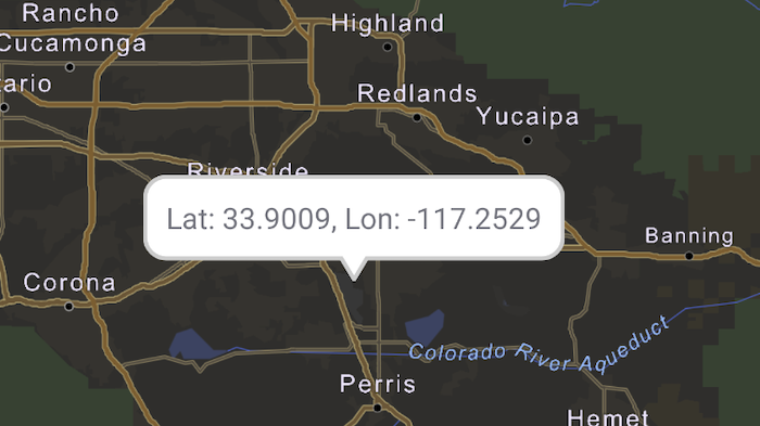
Show a callout with the latitude and longitude of user-tapped points.
Use case
Callouts are used to display temporary detail content on a map. You can display text and arbitrary UI controls in callouts.
How to use the sample
Tap anywhere on the map. A callout showing the WGS84 coordinates for the tapped point will appear.
How it works
- When the user taps, get the tapped location(map point) from the
SingleTapConfirmedEvent. - Project the point’s geometry to WGS84 using
GeometryEngine.projectOrNull(mapPoint, SpatialReference.wgs84()). - To the composable
MapView’s content, add a composableCalloutpassing it the locationPointand calloutContent string. - Changes to the
latLongPointvariable will trigger recomposition of theCallout.
Relevant API
- Callout
- GeometryEngine
- MapView
- Point
Additional information
This sample uses the GeoView-Compose Toolkit module to implement a composable MapView, which supports the use of Callouts.
Tags
balloon, bubble, callout, flyout, flyover, geoview-compose, info window, popup, tap, toolkit
Sample Code
/* Copyright 2023 Esri * * Licensed under the Apache License, Version 2.0 (the "License"); * you may not use this file except in compliance with the License. * You may obtain a copy of the License at * *    http://www.apache.org/licenses/LICENSE-2.0 * * Unless required by applicable law or agreed to in writing, software * distributed under the License is distributed on an "AS IS" BASIS, * WITHOUT WARRANTIES OR CONDITIONS OF ANY KIND, either express or implied. * See the License for the specific language governing permissions and * limitations under the License. * */
package com.esri.arcgismaps.sample.showcallout
import android.os.Bundleimport androidx.activity.ComponentActivityimport androidx.activity.compose.setContentimport androidx.activity.enableEdgeToEdgeimport androidx.compose.material3.MaterialThemeimport androidx.compose.material3.Surfaceimport androidx.compose.runtime.Composableimport com.arcgismaps.ApiKeyimport com.arcgismaps.ArcGISEnvironmentimport com.esri.arcgismaps.sample.sampleslib.theme.SampleAppThemeimport com.esri.arcgismaps.sample.showcallout.screens.MainScreen
class MainActivity : ComponentActivity() {
    override fun onCreate(savedInstanceState: Bundle?) {        super.onCreate(savedInstanceState)        // authentication with an API key or named user is        // required to access basemaps and other location services        ArcGISEnvironment.apiKey = ApiKey.create(BuildConfig.ACCESS_TOKEN)
        enableEdgeToEdge()        setContent {            SampleAppTheme {                ShowCalloutApp()            }        }    }
    @Composable    private fun ShowCalloutApp() {        Surface(            color = MaterialTheme.colorScheme.background        ) {            MainScreen(                sampleName = getString(R.string.show_callout_app_name)            )        }    }}
/* Copyright 2023 Esri * * Licensed under the Apache License, Version 2.0 (the "License"); * you may not use this file except in compliance with the License. * You may obtain a copy of the License at * * http://www.apache.org/licenses/LICENSE-2.0 * * Unless required by applicable law or agreed to in writing, software * distributed under the License is distributed on an "AS IS" BASIS, * WITHOUT WARRANTIES OR CONDITIONS OF ANY KIND, either express or implied. * See the License for the specific language governing permissions and * limitations under the License. * */
package com.esri.arcgismaps.sample.showcallout.components
import android.app.Applicationimport androidx.compose.runtime.getValueimport androidx.compose.runtime.mutableStateOfimport androidx.compose.runtime.setValueimport androidx.lifecycle.AndroidViewModelimport com.arcgismaps.geometry.GeometryEngineimport com.arcgismaps.geometry.Pointimport com.arcgismaps.geometry.SpatialReferenceimport com.arcgismaps.mapping.ArcGISMapimport com.arcgismaps.mapping.BasemapStyleimport com.arcgismaps.mapping.Viewpointimport com.arcgismaps.mapping.view.SingleTapConfirmedEventimport com.arcgismaps.toolkit.geoviewcompose.MapViewProxyimport com.esri.arcgismaps.sample.showcallout.R
class MapViewModel(private val application: Application) : AndroidViewModel(application) {
// Create a mapViewProxy that will be used to identify features in the MapView. // This should also be passed to the composable MapView this mapViewProxy is associated with. val mapViewProxy = MapViewProxy()
// Create an ArcGISMap with viewpoint set to Los Angeles, CA. val arcGISMap = ArcGISMap(BasemapStyle.ArcGISNavigationNight).apply { initialViewpoint = Viewpoint(34.056295, -117.195800, 1000000.0) }
// Keep track of the state of a lat/lon point. var latLonPoint: Point? by mutableStateOf(null) // Keep track of the state of the callout content String. var calloutContent: String by mutableStateOf("")
/** * Show a callout at the map point of the single tap event. */ fun showCalloutAt(singleTapConfirmedEvent: SingleTapConfirmedEvent) { // Get map point from the Single tap event. singleTapConfirmedEvent.mapPoint?.let { point -> // Convert the point to WGS84 to get a latitude and longitude coordinate. latLonPoint = GeometryEngine.projectOrNull( point, SpatialReference.wgs84() ) as Point // Set the callout text to display point coordinates. calloutContent = application.getString(R.string.callout_text, latLonPoint?.y, latLonPoint?.x) } }}/* Copyright 2023 Esri * * Licensed under the Apache License, Version 2.0 (the "License"); * you may not use this file except in compliance with the License. * You may obtain a copy of the License at * * http://www.apache.org/licenses/LICENSE-2.0 * * Unless required by applicable law or agreed to in writing, software * distributed under the License is distributed on an "AS IS" BASIS, * WITHOUT WARRANTIES OR CONDITIONS OF ANY KIND, either express or implied. * See the License for the specific language governing permissions and * limitations under the License. * */
package com.esri.arcgismaps.sample.showcallout.screens
import androidx.compose.foundation.layout.Columnimport androidx.compose.foundation.layout.PaddingValuesimport androidx.compose.foundation.layout.fillMaxSizeimport androidx.compose.foundation.layout.paddingimport androidx.compose.foundation.layout.sizeInimport androidx.compose.material3.MaterialThemeimport androidx.compose.material3.Scaffoldimport androidx.compose.material3.Textimport androidx.compose.runtime.Composableimport androidx.compose.ui.Modifierimport androidx.compose.ui.unit.dpimport androidx.lifecycle.viewmodel.compose.viewModelimport com.arcgismaps.toolkit.geoviewcompose.MapViewimport com.arcgismaps.toolkit.geoviewcompose.theme.CalloutDefaultsimport com.esri.arcgismaps.sample.sampleslib.components.SampleTopAppBarimport com.esri.arcgismaps.sample.showcallout.components.MapViewModel
/** * Main screen layout for the sample app */@Composablefun MainScreen(sampleName: String) { // create a ViewModel to handle MapView interactions val mapViewModel: MapViewModel = viewModel()
Scaffold( topBar = { SampleTopAppBar(title = sampleName) }, content = { Column( modifier = Modifier .fillMaxSize() .padding(it) ) { MapView( modifier = Modifier .fillMaxSize(), mapViewProxy = mapViewModel.mapViewProxy, arcGISMap = mapViewModel.arcGISMap, onSingleTapConfirmed = mapViewModel::showCalloutAt, content = { // Show a callout only when a lat/lon point is available. mapViewModel.latLonPoint?.let { point -> Callout( modifier = Modifier.sizeIn(maxWidth = 250.dp), location = point, // Optional parameters to customize the callout appearance. shapes = CalloutDefaults.shapes( calloutContentPadding = PaddingValues(4.dp) ), colorScheme = CalloutDefaults.colors( backgroundColor = MaterialTheme.colorScheme.background, borderColor = MaterialTheme.colorScheme.outline ) ) { // Callout content: Text( text = mapViewModel.calloutContent, style = MaterialTheme.typography.labelSmall ) } } } ) } } )}