Limit the view of a map to a particular area.
Use case
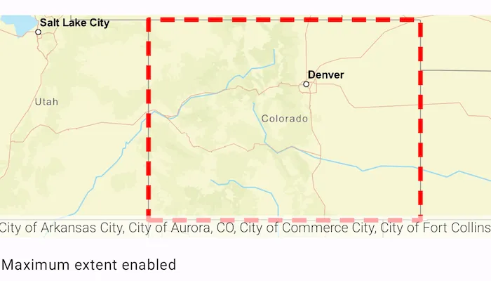
When showing map information relevant to only a certain area, you may wish to constrain the user’s ability to pan or zoom away.
How to use the sample
The application loads with a map whose maximum extent has been set to the borders of Colorado. Note that you won’t be able to pan far from the Colorado border or zoom out beyond the minimum scale set by the max extent. Use the toggle switch to disable the max extent to freely pan/zoom around the map.
How it works
- Create an
ArcGISMapobject. - Create an envelop of the extent using
Envelope(Point(x, y), Point(x, y)) - Set the maximum extent of the map with
map.maxExtent = envelope. - Set the map to a
MapViewobject. - Set
map.maxExtent = nullto disable the maximum extent of the map
Relevant API
- ArcGISMap
- Envelope
Additional information
This sample uses the GeoView-Compose Toolkit module to be able to implement a composable MapView.
Tags
extent, geoview-compose, limit panning, map, mapview, max extent, toolkit, zoom
Sample code
/* Copyright 2025 Esri * * Licensed under the Apache License, Version 2.0 (the "License"); * you may not use this file except in compliance with the License. * You may obtain a copy of the License at * *    http://www.apache.org/licenses/LICENSE-2.0 * * Unless required by applicable law or agreed to in writing, software * distributed under the License is distributed on an "AS IS" BASIS, * WITHOUT WARRANTIES OR CONDITIONS OF ANY KIND, either express or implied. * See the License for the specific language governing permissions and * limitations under the License. * */
package com.esri.arcgismaps.sample.setmaxextent.components
import android.app.Applicationimport androidx.compose.runtime.getValueimport androidx.compose.runtime.mutableStateOfimport androidx.compose.runtime.setValueimport androidx.lifecycle.AndroidViewModelimport androidx.lifecycle.viewModelScopeimport com.arcgismaps.Colorimport com.arcgismaps.geometry.Envelopeimport com.arcgismaps.geometry.Pointimport com.arcgismaps.mapping.ArcGISMapimport com.arcgismaps.mapping.BasemapStyleimport com.arcgismaps.mapping.symbology.SimpleLineSymbolimport com.arcgismaps.mapping.symbology.SimpleLineSymbolStyleimport com.arcgismaps.mapping.symbology.SimpleRendererimport com.arcgismaps.mapping.view.Graphicimport com.arcgismaps.mapping.view.GraphicsOverlayimport com.esri.arcgismaps.sample.sampleslib.components.MessageDialogViewModelimport kotlinx.coroutines.launch
class SetMaxExtentViewModel(app: Application) : AndroidViewModel(app) {
    // defines an envelope representing a rectangular area    private val extentEnvelope = Envelope(        Point(-12139393.2109, 5012444.0468),        Point(-11359277.5124, 4438148.7816)    )
    // create a map with the BasemapStyle streets focused on Colorado    val coloradoMap = ArcGISMap(BasemapStyle.ArcGISStreets).apply {        // set the map's max extent to an envelope of Colorado's northwest and southeast corners        maxExtent = extentEnvelope    }
    // Create a message dialog view model for handling error messages    val messageDialogVM = MessageDialogViewModel()
    init {        viewModelScope.launch {            coloradoMap.load().onFailure { messageDialogVM.showMessageDialog(it) }        }    }
    // create a graphics overlay of the map's max extent    val coloradoGraphicsOverlay = GraphicsOverlay().apply {        // set the graphic's geometry to the max extent of the map        graphics.add(Graphic(coloradoMap.maxExtent))        // create a simple red dashed line renderer        renderer = SimpleRenderer(SimpleLineSymbol(SimpleLineSymbolStyle.Dash, Color.red, 5f))    }
    // graphics overlays that are applied to the map    val graphicsOverlays = listOf(coloradoGraphicsOverlay)
    // tracks whether the max extent feature is currently enabled.    var maxExtentEnabled by mutableStateOf(true)
    // this function is called when the switch is toggled.    fun onSwitch(isChecked: Boolean){        // set max extent to the state of Colorado        if(isChecked) {            coloradoMap.maxExtent = extentEnvelope        }        // disable the max extent of the map, map is free to pan around        else {            coloradoMap.maxExtent = null        }
        maxExtentEnabled = isChecked    }}
/* Copyright 2025 Esri * * Licensed under the Apache License, Version 2.0 (the "License"); * you may not use this file except in compliance with the License. * You may obtain a copy of the License at * * http://www.apache.org/licenses/LICENSE-2.0 * * Unless required by applicable law or agreed to in writing, software * distributed under the License is distributed on an "AS IS" BASIS, * WITHOUT WARRANTIES OR CONDITIONS OF ANY KIND, either express or implied. * See the License for the specific language governing permissions and * limitations under the License. * */
package com.esri.arcgismaps.sample.setmaxextent
import android.os.Bundleimport androidx.activity.ComponentActivityimport androidx.activity.compose.setContentimport androidx.activity.enableEdgeToEdgeimport androidx.compose.material3.MaterialThemeimport androidx.compose.material3.Surfaceimport androidx.compose.runtime.Composableimport com.arcgismaps.ApiKeyimport com.arcgismaps.ArcGISEnvironmentimport com.esri.arcgismaps.sample.sampleslib.theme.SampleAppThemeimport com.esri.arcgismaps.sample.setmaxextent.screens.SetMaxExtentScreen
class MainActivity : ComponentActivity() {
override fun onCreate(savedInstanceState: Bundle?) { super.onCreate(savedInstanceState) // authentication with an API key or named user is // required to access basemaps and other location services ArcGISEnvironment.apiKey = ApiKey.create(BuildConfig.ACCESS_TOKEN)
enableEdgeToEdge() setContent { SampleAppTheme { SetMaxExtentApp() } } }
@Composable private fun SetMaxExtentApp() { Surface(color = MaterialTheme.colorScheme.background) { SetMaxExtentScreen( sampleName = getString(R.string.set_max_extent_app_name) ) } }}/* Copyright 2025 Esri * * Licensed under the Apache License, Version 2.0 (the "License"); * you may not use this file except in compliance with the License. * You may obtain a copy of the License at * * http://www.apache.org/licenses/LICENSE-2.0 * * Unless required by applicable law or agreed to in writing, software * distributed under the License is distributed on an "AS IS" BASIS, * WITHOUT WARRANTIES OR CONDITIONS OF ANY KIND, either express or implied. * See the License for the specific language governing permissions and * limitations under the License. * */
package com.esri.arcgismaps.sample.setmaxextent.screens
import androidx.compose.foundation.layout.Arrangementimport androidx.compose.foundation.layout.Columnimport androidx.compose.foundation.layout.Rowimport androidx.compose.foundation.layout.fillMaxSizeimport androidx.compose.foundation.layout.fillMaxWidthimport androidx.compose.foundation.layout.paddingimport androidx.compose.material3.Scaffoldimport androidx.compose.material3.Switchimport androidx.compose.material3.Textimport androidx.compose.runtime.Composableimport androidx.compose.ui.Alignmentimport androidx.compose.ui.Modifierimport androidx.compose.ui.res.stringResourceimport androidx.compose.ui.unit.dpimport androidx.lifecycle.viewmodel.compose.viewModelimport com.arcgismaps.toolkit.geoviewcompose.MapViewimport com.esri.arcgismaps.sample.setmaxextent.components.SetMaxExtentViewModelimport com.esri.arcgismaps.sample.sampleslib.components.MessageDialogimport com.esri.arcgismaps.sample.sampleslib.components.SampleTopAppBarimport com.esri.arcgismaps.sample.setmaxextent.R
/** * Main screen layout for the sample app */@Composablefun SetMaxExtentScreen(sampleName: String) { val mapViewModel: SetMaxExtentViewModel = viewModel()
Scaffold( topBar = { SampleTopAppBar(title = sampleName) }, content = { Column( modifier = Modifier .fillMaxSize() .padding(it) ) { MapView( modifier = Modifier .fillMaxSize() .weight(1f), arcGISMap = mapViewModel.coloradoMap, graphicsOverlays = mapViewModel.graphicsOverlays ) Row( modifier = Modifier .fillMaxWidth() .padding(5.dp), horizontalArrangement = Arrangement.SpaceBetween ) { Text( if (mapViewModel.maxExtentEnabled) stringResource(R.string.max_extent_enabled) else stringResource(R.string.max_extent_disabled), modifier = Modifier.align(Alignment.CenterVertically)) Switch ( checked = mapViewModel.maxExtentEnabled, onCheckedChange = mapViewModel::onSwitch, modifier = Modifier.align(Alignment.CenterVertically) ) } }
mapViewModel.messageDialogVM.apply { if (dialogStatus) { MessageDialog( title = messageTitle, description = messageDescription, onDismissRequest = ::dismissDialog ) } } } )}