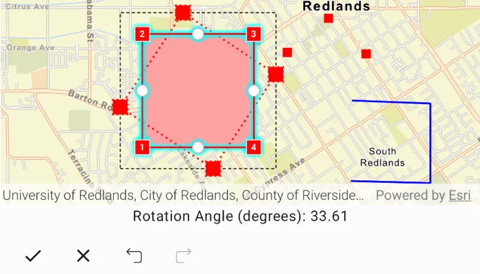
See information about the previewed geometry during an interaction using the geometry editor.
Use case
The geometry editor can provide information about the geometry being created or edited during an interaction. This information can be used to give feedback to the user to show the effect of the interaction on the geometry.
How to use the sample
Tap a graphic to edit its geometry by moving, rotating, or scaling the geometry. During the interaction, information about the changes will be displayed to provide feedback to the user.
Use the buttons in the settings view to undo or redo changes made to the geometry. Use the cancel and done buttons to discard and save changes.
How it works
- Create a
MapViewProxyfor interacting with the composableMapView. - Create a composable
MapViewand pass in themapViewProxyandgeometryEditor(for example,MapView(mapViewProxy = mapViewProxy, geometryEditor = geometryEditor, ...)). - Add an event handler to listen to
GeometryEditor.interactionPreviewChanged.- This event can be used to get information on the state of the geometry during an interaction with the
GeometryEditorInteractionPreviewparameter.- The
previewGeometryrepresents the geometry’s state at that moment. - The
interactionTypecan be used to determine the type of interaction that is occurring (create,move,rotate,scale). - The
interactionElementcan be used to determine the element being interacted with (GeometryEditorVertex,GeometryEditorPart,GeometryEditorGeometry).
- The
- This event can be used to get information on the state of the geometry during an interaction with the
- Start the
GeometryEditorusingGeometryEditor.start(Geometry)to edit the geometry of one of the graphics.- To identify the
Graphic, useMapViewProxy.identifyGraphicsOverlays(...)and take the first result.
- To identify the
- Call
GeometryEditor.stop()to finish the editing session, and use the geometry returned from this method to update the existingGraphics.geometry.
Relevant API
- Geometry
- GeometryEditor
- GeometryEditor.interactionPreviewChanged
- GeometryEditorInteractionPreview
- GeometryEditorInteractionType
- Graphic
- GraphicsOverlay
Additional information
The GeometryEditor.interactionPreviewChanged event fires continuously during an interaction, therefore it’s not recommended to use it as a trigger for resource intensive actions.
Tags
draw, edit, geometry editor, interaction preview
Sample code
/* Copyright 2026 Esri * * Licensed under the Apache License, Version 2.0 (the "License"); * you may not use this file except in compliance with the License. * You may obtain a copy of the License at * *    http://www.apache.org/licenses/LICENSE-2.0 * * Unless required by applicable law or agreed to in writing, software * distributed under the License is distributed on an "AS IS" BASIS, * WITHOUT WARRANTIES OR CONDITIONS OF ANY KIND, either express or implied. * See the License for the specific language governing permissions and * limitations under the License. * */
package com.esri.arcgismaps.sample.displaygeometryeditorinformationduringinteraction.components
import android.app.Applicationimport androidx.compose.ui.unit.dpimport androidx.lifecycle.AndroidViewModelimport androidx.lifecycle.viewModelScopeimport com.arcgismaps.Colorimport com.arcgismaps.geometry.Geometryimport com.arcgismaps.geometry.Multipointimport com.arcgismaps.geometry.Pointimport com.arcgismaps.geometry.Polygonimport com.arcgismaps.geometry.Polylineimport com.arcgismaps.geometry.SpatialReferenceimport com.arcgismaps.mapping.ArcGISMapimport com.arcgismaps.mapping.BasemapStyleimport com.arcgismaps.mapping.Viewpointimport com.arcgismaps.mapping.symbology.SimpleFillSymbolimport com.arcgismaps.mapping.symbology.SimpleFillSymbolStyleimport com.arcgismaps.mapping.symbology.SimpleLineSymbolimport com.arcgismaps.mapping.symbology.SimpleLineSymbolStyleimport com.arcgismaps.mapping.symbology.SimpleMarkerSymbolimport com.arcgismaps.mapping.symbology.SimpleMarkerSymbolStyleimport com.arcgismaps.mapping.view.Graphicimport com.arcgismaps.mapping.view.GraphicsOverlayimport com.arcgismaps.mapping.view.SingleTapConfirmedEventimport com.arcgismaps.mapping.view.geometryeditor.GeometryEditorimport com.arcgismaps.mapping.view.geometryeditor.GeometryEditorInteractionPreviewimport com.arcgismaps.mapping.view.geometryeditor.GeometryEditorInteractionTypeimport com.arcgismaps.mapping.view.geometryeditor.VertexToolimport com.arcgismaps.toolkit.geoviewcompose.MapViewProxyimport com.esri.arcgismaps.sample.sampleslib.components.MessageDialogViewModelimport kotlinx.coroutines.flow.MutableStateFlowimport kotlinx.coroutines.flow.asStateFlowimport kotlinx.coroutines.launchimport java.util.Localeimport kotlin.math.PIimport kotlin.math.atan2
class DisplayGeometryEditorInformationDuringInteractionViewModel(app: Application) :    AndroidViewModel(app) {
    // Create a map with an initial viewpoint of Redlands, CA.    val arcGISMap = ArcGISMap(BasemapStyle.ArcGISStreets).apply {        initialViewpoint = Viewpoint(            center = Point(                x = -13.045e6, y = 4.0356e6,                spatialReference = SpatialReference.webMercator()            ),            scale = 4e4        )    }
    // Create a message dialog view model for handling error messages    val messageDialogVM = MessageDialogViewModel()
    // Create a MapViewProxy that will be used to identify features in the MapView    val mapViewProxy = MapViewProxy()
    // Track graphics identified on tap    private var identifiedGraphic: Graphic? = null
    // Create a graphics overlay    val graphicsOverlay = GraphicsOverlay()
    // Create a geometry editor    val geometryEditor = GeometryEditor().apply {        tool = VertexTool().apply {            configuration.apply {                allowVertexCreation = false                allowMidVertexSelection = false                allowDeletingSelectedElement = false                allowVertexSelection = false                allowPartCreation = false            }        }    }
    private val polygonLineSymbol = SimpleLineSymbol(        style = SimpleLineSymbolStyle.Dash,        color = Color.black,        width = 1f    )    private val polygonSymbol = SimpleFillSymbol(        style = SimpleFillSymbolStyle.Solid,        color = Color.fromRgba(r = 255, g = 0, b = 0, a = 100),        outline = polygonLineSymbol    )    private val polylineSymbol = SimpleLineSymbol(        style = SimpleLineSymbolStyle.Solid,        color = Color.blue,        width = 2f    )    private val pointSymbol = SimpleMarkerSymbol(        style = SimpleMarkerSymbolStyle.Square,        color = Color.red,        size = 10f    )
    // State flow string message of rotation angle, scale factors, or coordinates, for presentation in UI    private val _interactionTransformationMessage = MutableStateFlow<String?>(null)    val interactionTransformationMessage = _interactionTransformationMessage.asStateFlow()
    init {        viewModelScope.launch {            arcGISMap.load().onFailure { messageDialogVM.showMessageDialog(it) }.onSuccess {                // Create graphics for the initial geometries and add them to the graphics overlay                graphicsOverlay.graphics.addAll(                    listOf(                        Graphic(                            geometry = Geometry.fromJsonOrNull(redlandsPolygonJson),                            symbol = polygonSymbol                        ),                        Graphic(                            geometry = Geometry.fromJsonOrNull(redlandsPolylineJson),                            symbol = polylineSymbol                        ),                        Graphic(                            geometry = Geometry.fromJsonOrNull(redlandsMultipointJson),                            symbol = pointSymbol                        )                    )                )
                // Update the transformation information in the formatted message whenever the                // interaction preview changes in the geometry editor                geometryEditor.interactionPreviewChanged.collect { interactionPreviewChanged ->                    val interactionMessage = interactionPreviewChanged.interactionPreview                        ?.toFormattedMessage(geometryEditor.geometry.value)                    _interactionTransformationMessage.value = interactionMessage                }            }        }    }
    /**     * Stops the GeometryEditor and updates the identified graphic.     */    fun stopEditor() {        // Check if there was a previously identified graphic        identifiedGraphic?.let { graphic ->            // Update the identified graphic geometry            graphic.geometry = geometryEditor.stop()            // Set the original graphic to visible again            graphic.isVisible = true        }    }
    /**     * Discards the current changes made in the GeometryEditor.     */    fun discardEdits() {        geometryEditor.stop()        // Update previously identified graphic to be visible again        identifiedGraphic?.let { graphic ->            graphic.isVisible = true        }    }
    /**     * Undoes the last event on the geometry editor if possible.     */    fun undoEdit() {        if (geometryEditor.canUndo.value) {            geometryEditor.undo()        }    }
    /**     * Redoes the last event on the geometry editor if possible.     */    fun redoEdit() {        if (geometryEditor.canRedo.value) {            geometryEditor.redo()        }    }
    /**     * Identifies the graphic at the tapped screen coordinate in the provided [singleTapConfirmedEvent]     * and starts the GeometryEditor using the identified graphic's geometry.     */    fun identify(singleTapConfirmedEvent: SingleTapConfirmedEvent) {        viewModelScope.launch {            if (!geometryEditor.isStarted.value) {
                // Attempt to identify a graphic at the location the user tapped                val graphicsResult = mapViewProxy.identifyGraphicsOverlays(                    screenCoordinate = singleTapConfirmedEvent.screenCoordinate,                    tolerance = 10.0.dp,                    returnPopupsOnly = false                ).getOrNull()
                if (graphicsResult != null) {                    if (graphicsResult.isNotEmpty()) {                        // Get the tapped graphic                        identifiedGraphic = graphicsResult.first().graphics.first()                        // Start the geometry editor with the identified graphic                        identifiedGraphic?.let { graphic ->                            graphic.geometry?.let { geometry ->                                geometryEditor.start(geometry)                                geometryEditor.selectGeometry()                                graphic.isVisible = false                            }                        }                    }                }            }        }    }}
/** * Converts the transformation information to a formatted string using the editor interaction preview, type, or [geometry]. */private fun GeometryEditorInteractionPreview.toFormattedMessage(geometry: Geometry?): String? {    return when (interactionType) {        is GeometryEditorInteractionType.Rotate -> buildRotationMessage(geometry)        is GeometryEditorInteractionType.Scale -> buildScaleMessage(geometry)        is GeometryEditorInteractionType.Move -> buildMoveMessage()        else -> null    }}
/** * Calculates the rotation angle based on the current interaction preview and * returns a string representation of the rotation angle in degrees. */private fun GeometryEditorInteractionPreview.buildRotationMessage(geometry: Geometry?): String? {    val sourceGeometry = geometry ?: return null    val center = sourceGeometry.extent.center    val originalPoint = sourceGeometry.firstRotationReferencePoint(center) ?: return null    val previewPoint = previewGeometry.firstRotationReferencePoint(center) ?: return null    if (originalPoint == previewPoint) return null
    val vector1X = originalPoint.x - center.x    val vector2X = previewPoint.x - center.x    val vector1Y = originalPoint.y - center.y    val vector2Y = previewPoint.y - center.y
    val cross = vector1X * vector2Y - vector1Y * vector2X    val dot = vector1X * vector2X + vector1Y * vector2Y    val angle = atan2(cross, dot) * (180.0 / PI)    val clockwiseNormalized = ((-angle % 360) + 360) % 360
    return "Rotation Angle (degrees): ${clockwiseNormalized.toDisplayString()}"}
/** * Calculates the scale factors based on the current interaction preview and * returns a string representation of the scale factors. */private fun GeometryEditorInteractionPreview.buildScaleMessage(geometry: Geometry?): String? {    val geometryExtent = geometry?.extent ?: return null    if (geometryExtent.width == 0.0 || geometryExtent.height == 0.0) return null    val previewExtent = previewGeometry.extent
    return formatValuePair(        label = "Scale Factor (X, Y)",        first = previewExtent.width / geometryExtent.width,        second = previewExtent.height / geometryExtent.height    )}
/** * Calculates the center point of the current interaction preview to * return a formatted message for move interactions. */private fun GeometryEditorInteractionPreview.buildMoveMessage(): String {    return formatValuePair(        label = "Center (X, Y)",        first = previewGeometry.extent.center.x,        second = previewGeometry.extent.center.y    )}
/** * Returns the first point in the geometry that is not the [center] point. */private fun Geometry.firstRotationReferencePoint(center: Point): Point? {    return when (this) {        is Polyline, is Polygon -> parts[0].points.firstOrNull { point -> point != center }        is Multipoint -> points.firstOrNull { point -> point != center }        else -> null    }}
private fun formatValuePair(label: String, first: Double, second: Double): String {    return "$label: ${first.toDisplayString()}, ${second.toDisplayString()}"}
private fun Double.toDisplayString(): String {    return String.format(Locale.getDefault(), "%.2f", this)}
// JSON formatted strings for displayed geometries.private const val redlandsPolygonJson = """{ "rings": [[[-13046991.222211758,4034618.5047884779],            [-13046991.222211758,4035962.0723415823],            [-13045677.652220398,4035962.0723415823],            [-13045677.652220398,4034618.5047884779],            [-13046991.222211758,4034618.5047884779]]],            "spatialReference":{"wkid":3857}}"""private const val redlandsPolylineJson = """{ "paths": [[[-13044533.805088846,4034221.5100018946],            [-13043597.938505623,4034197.1337576872],            [-13043597.938505623,4035135.572073034],            [-13044522.634505576,4035170.5449295067]]],            "spatialReference":{"wkid":3857}}"""private const val redlandsMultipointJson = """{ "points": [[-13045283.292102993,4035739.1925106063],            [-13045314.922186911,4036533.8852012255],            [-13044798.24723932,4036138.7808295386],            [-13044354.514637273,4035719.3623426706],            [-13044281.57229173,4036473.0999132735]],            "spatialReference":{"wkid":3857}}"""
/* Copyright 2026 Esri * * Licensed under the Apache License, Version 2.0 (the "License"); * you may not use this file except in compliance with the License. * You may obtain a copy of the License at * * http://www.apache.org/licenses/LICENSE-2.0 * * Unless required by applicable law or agreed to in writing, software * distributed under the License is distributed on an "AS IS" BASIS, * WITHOUT WARRANTIES OR CONDITIONS OF ANY KIND, either express or implied. * See the License for the specific language governing permissions and * limitations under the License. * */
package com.esri.arcgismaps.sample.displaygeometryeditorinformationduringinteraction
import android.os.Bundleimport androidx.activity.ComponentActivityimport androidx.activity.compose.setContentimport androidx.activity.enableEdgeToEdgeimport androidx.compose.material3.MaterialThemeimport androidx.compose.material3.Surfaceimport androidx.compose.runtime.Composableimport com.esri.arcgismaps.sample.sampleslib.theme.SampleAppThemeimport com.esri.arcgismaps.sample.displaygeometryeditorinformationduringinteraction.screens.DisplayGeometryEditorInformationDuringInteractionScreen
class MainActivity : ComponentActivity() {
override fun onCreate(savedInstanceState: Bundle?) { super.onCreate(savedInstanceState) enableEdgeToEdge() setContent { SampleAppTheme { DisplayGeometryEditorInformationDuringInteractionApp() } } }
@Composable private fun DisplayGeometryEditorInformationDuringInteractionApp() { Surface(color = MaterialTheme.colorScheme.background) { DisplayGeometryEditorInformationDuringInteractionScreen( sampleName = getString(R.string.display_geometry_editor_information_during_interaction_app_name) ) } }}/* Copyright 2026 Esri * * Licensed under the Apache License, Version 2.0 (the "License"); * you may not use this file except in compliance with the License. * You may obtain a copy of the License at * * http://www.apache.org/licenses/LICENSE-2.0 * * Unless required by applicable law or agreed to in writing, software * distributed under the License is distributed on an "AS IS" BASIS, * WITHOUT WARRANTIES OR CONDITIONS OF ANY KIND, either express or implied. * See the License for the specific language governing permissions and * limitations under the License. * */
package com.esri.arcgismaps.sample.displaygeometryeditorinformationduringinteraction.screens
import androidx.compose.animation.animateContentSizeimport androidx.compose.foundation.layout.Arrangementimport androidx.compose.foundation.layout.Columnimport androidx.compose.foundation.layout.Rowimport androidx.compose.foundation.layout.fillMaxSizeimport androidx.compose.foundation.layout.fillMaxWidthimport androidx.compose.foundation.layout.paddingimport androidx.compose.material.icons.Iconsimport androidx.compose.material.icons.automirrored.filled.Redoimport androidx.compose.material.icons.automirrored.filled.Undoimport androidx.compose.material.icons.filled.Checkimport androidx.compose.material.icons.filled.Clearimport androidx.compose.material3.Iconimport androidx.compose.material3.IconButtonimport androidx.compose.material3.Scaffoldimport androidx.compose.material3.Textimport androidx.compose.runtime.Composableimport androidx.compose.runtime.getValueimport androidx.compose.ui.Modifierimport androidx.compose.ui.res.stringResourceimport androidx.compose.ui.text.style.TextAlignimport androidx.compose.ui.unit.dpimport androidx.lifecycle.compose.collectAsStateWithLifecycleimport androidx.lifecycle.viewmodel.compose.viewModelimport com.arcgismaps.toolkit.geoviewcompose.MapViewimport com.esri.arcgismaps.sample.displaygeometryeditorinformationduringinteraction.Rimport com.esri.arcgismaps.sample.displaygeometryeditorinformationduringinteraction.components.DisplayGeometryEditorInformationDuringInteractionViewModelimport com.esri.arcgismaps.sample.sampleslib.components.MessageDialogimport com.esri.arcgismaps.sample.sampleslib.components.SampleTopAppBar
/** * Main screen layout for the sample app */@Composablefun DisplayGeometryEditorInformationDuringInteractionScreen(sampleName: String) { val mapViewModel: DisplayGeometryEditorInformationDuringInteractionViewModel = viewModel() val transformationInfo by mapViewModel.interactionTransformationMessage.collectAsStateWithLifecycle() val editorStarted by mapViewModel.geometryEditor.isStarted.collectAsStateWithLifecycle() val canUndo by mapViewModel.geometryEditor.canUndo.collectAsStateWithLifecycle() val canRedo by mapViewModel.geometryEditor.canRedo.collectAsStateWithLifecycle() val displayText = if (editorStarted) { transformationInfo ?: stringResource(R.string.transform_drag_handles) } else { stringResource(R.string.tap_on_geometry_to_interact) }
Scaffold( topBar = { SampleTopAppBar(title = sampleName) }, content = { Column( modifier = Modifier .fillMaxSize() .padding(it), verticalArrangement = Arrangement.spacedBy(4.dp) ) { MapView( modifier = Modifier .fillMaxSize() .animateContentSize() .weight(1f), arcGISMap = mapViewModel.arcGISMap, mapViewProxy = mapViewModel.mapViewProxy, geometryEditor = mapViewModel.geometryEditor, graphicsOverlays = listOf(mapViewModel.graphicsOverlay), onSingleTapConfirmed = mapViewModel::identify )
Text( modifier = Modifier .fillMaxWidth() .animateContentSize(), text = displayText, textAlign = TextAlign.Center )
ButtonMenuOptions( isGeometryEditorStarted = editorStarted, canGeometryEditorUndo = canUndo, canGeometryEditorRedo = canRedo, onStopEditingButtonClick = mapViewModel::stopEditor, onDiscardEditsButtonClick = mapViewModel::discardEdits, onUndoButtonClick = mapViewModel::undoEdit, onRedoButtonClick = mapViewModel::redoEdit ) }
mapViewModel.messageDialogVM.apply { if (dialogStatus) { MessageDialog( title = messageTitle, description = messageDescription, onDismissRequest = ::dismissDialog ) } } } )}
/** * Composable component to display the menu buttons. */@Composablefun ButtonMenuOptions( isGeometryEditorStarted: Boolean, canGeometryEditorUndo: Boolean, canGeometryEditorRedo: Boolean, onStopEditingButtonClick: () -> Unit, onDiscardEditsButtonClick: () -> Unit, onUndoButtonClick: () -> Unit, onRedoButtonClick: () -> Unit,) { Row( modifier = Modifier .fillMaxWidth() .padding(4.dp), horizontalArrangement = Arrangement.SpaceEvenly, ) { IconButton( enabled = isGeometryEditorStarted, onClick = onStopEditingButtonClick ) { Icon(imageVector = Icons.Default.Check, contentDescription = "Save Edits") }
IconButton( enabled = isGeometryEditorStarted, onClick = onDiscardEditsButtonClick ) { Icon(imageVector = Icons.Default.Clear, contentDescription = "Discard Edits") }
IconButton( enabled = canGeometryEditorUndo, onClick = onUndoButtonClick ) { Icon(imageVector = Icons.AutoMirrored.Filled.Undo, contentDescription = "Undo") }
IconButton( enabled = canGeometryEditorRedo, onClick = onRedoButtonClick ) { Icon(imageVector = Icons.AutoMirrored.Filled.Redo, contentDescription = "Redo") } }}